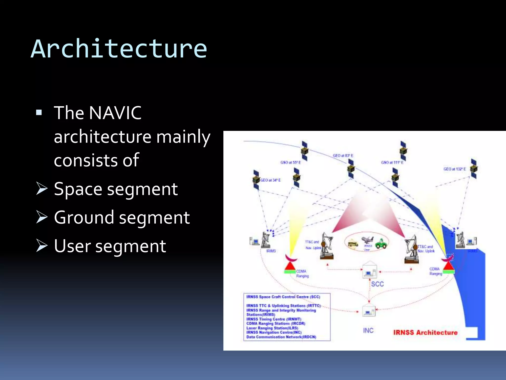
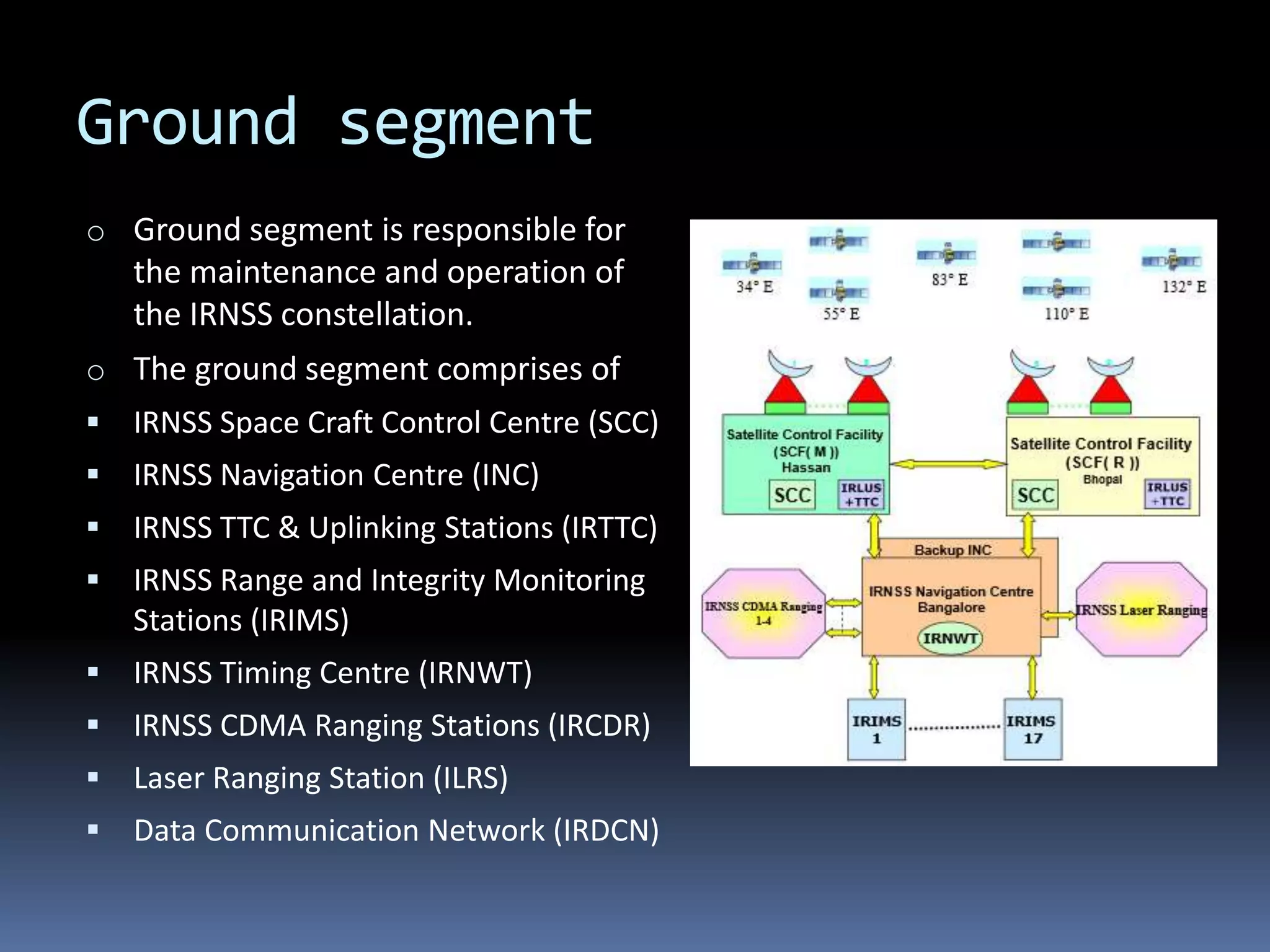
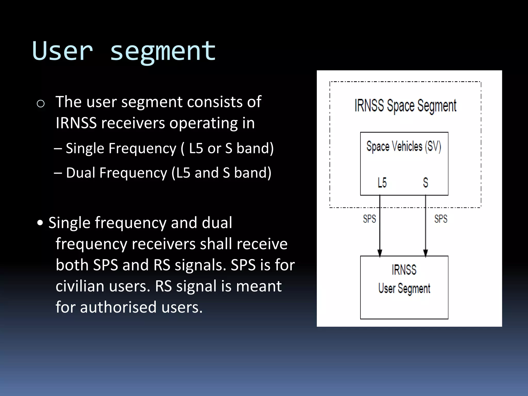
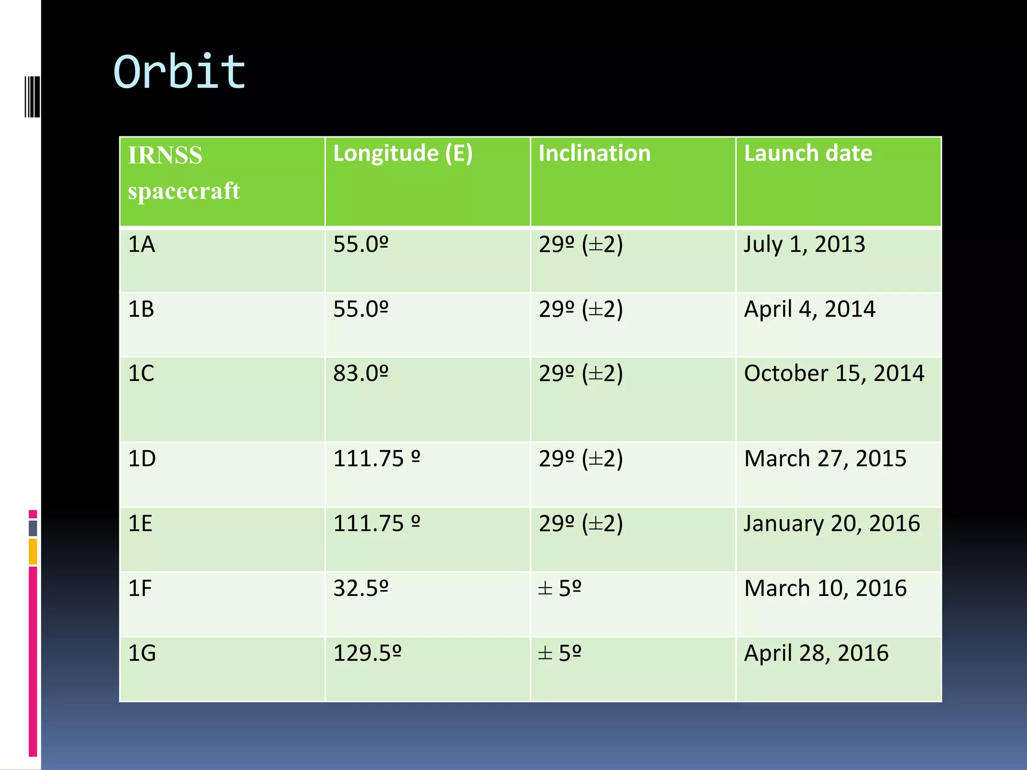
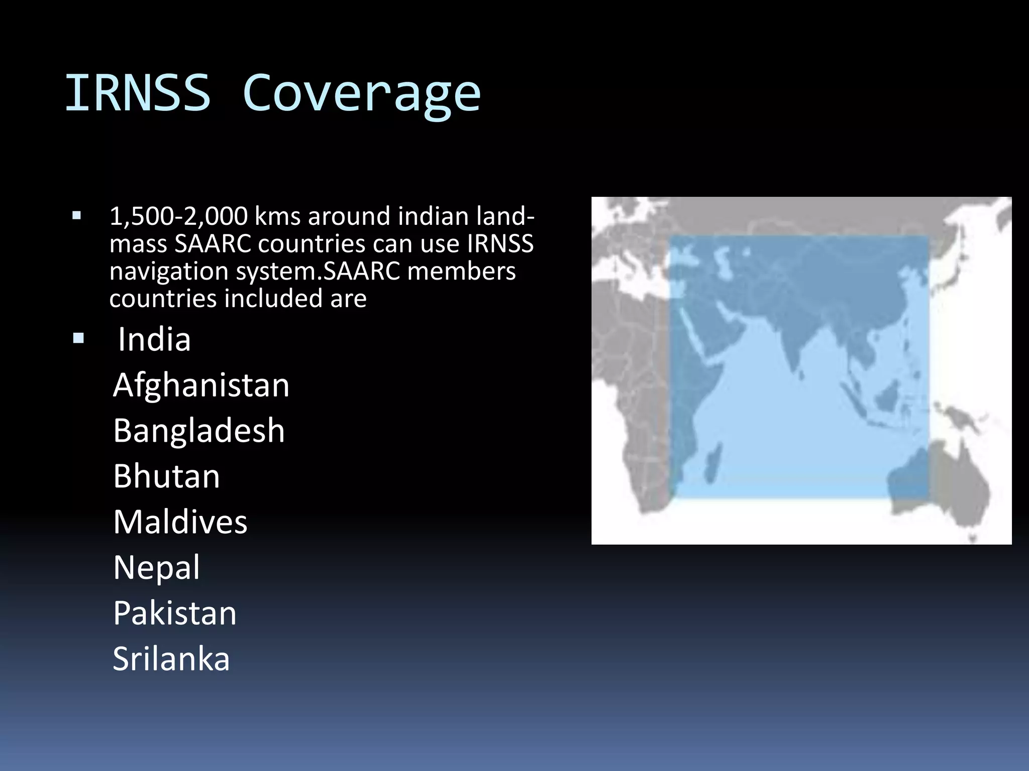
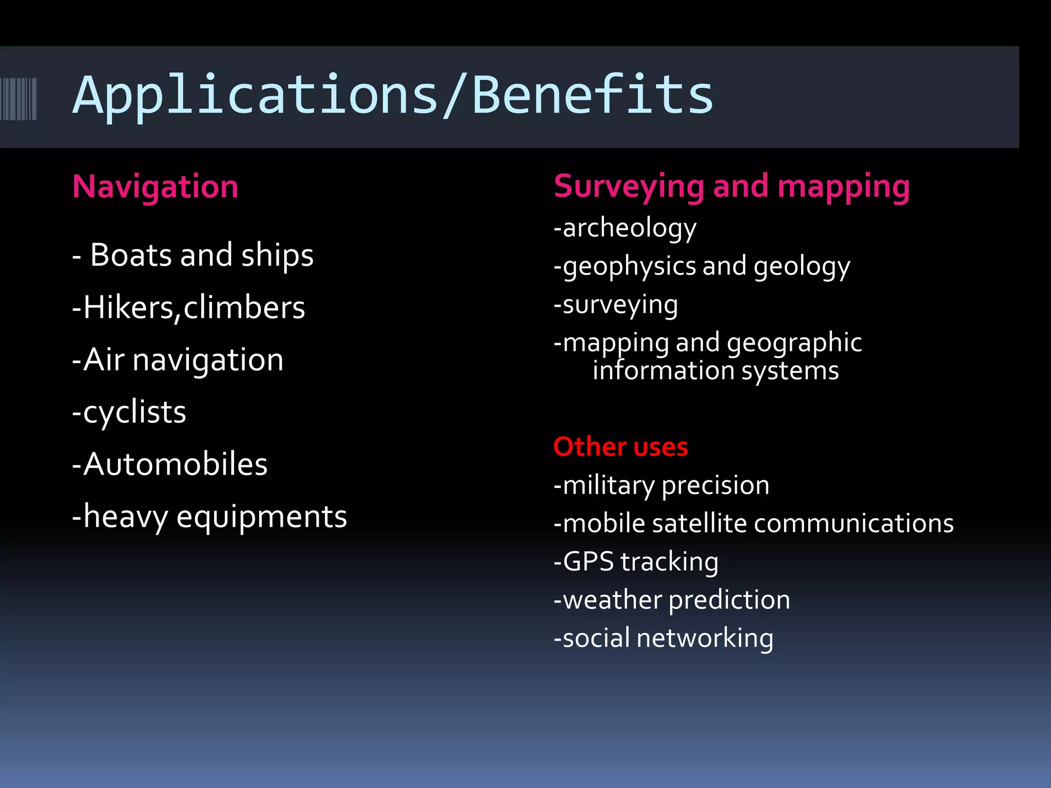
NAVIC
NAVigation with Indian Constellation
Presented By:
VELICHETI UDAY KUMAR
CONTENTS
 Introduction
 Why launched?
 Other navigation satellite systems
 The beginning
 Architecture
 Satellites
 Navic coverage
 Applications /Benefits
 conclusion
Introduction
 The indian regional navigation satellite system or IRNSS
 In April 2016,with the last launch of constellation satellite ,
IRNSS was renamed “NAVIC” by indian prime minister
‘Narendra modi’.
 NAVIC – Navigation with Indian Constellation
 NAVIC means “sailor” or “navigator” in Sanskrit, Hindi and
many other indian languages.
 An autonomous regional satellite navigation system.
 provide accurate real –time positioning and timing services
over India and the region extending to 1500 km (930 miles )
around india .
Why launched?
 Access to foreign government controlled
‘Global Navigation Satellite Systems ‘ is not
guaranteed in hostile situations
 As happened to the Indian Military in 1999
when it was dependent on the American GPS
during the kargil war.
Other Navigation satellite system
 USA – Global
positioning system
(GPS)
 RUSSIA – Glonass
 EU- Gallileo
 CHINA – Beiduo(BDS)
 INDIA – NAVIC (IRNSS)
The Beginning
 Approved by government of
india in May 2006
 The total cost of the project is
expected to be Rs 1420 crores
 The full system comprises 9
satellites
 3 satellites in GEO orbit
 4 satellites in GSO orbit
 2 on the ground as stand by
GEO Vs GSO
.
Architecture
 The NAVIC
architecture mainly
consists of
 Space segment
 Ground segment
 User segment
Space Segment
o Minimum number of
satellites required for IRNSS
constellation is worked out
to be 7 (3 geo and 4 gso ).
o The 3 geo will be located at
32.5°, 83° and 131.5° East.
and
o the 4 gso have their
longitude crossings 55° east
and 111.75º East (two in
each plane).
Ground segment
o Ground segment is responsible for
the maintenance and operation of
the IRNSS constellation.
o The ground segment comprises of
 IRNSS Space Craft Control Centre (SCC)
 IRNSS Navigation Centre (INC)
 IRNSS TTC & Uplinking Stations (IRTTC)
 IRNSS Range and Integrity Monitoring
Stations (IRIMS)
 IRNSS Timing Centre (IRNWT)
 IRNSS CDMA Ranging Stations (IRCDR)
 Laser Ranging Station (ILRS)
 Data Communication Network (IRDCN)
User segment
o The user segment consists of
IRNSS receivers operating in
– Single Frequency ( L5 or S band)
– Dual Frequency (L5 and S band)
• Single frequency and dual
frequency receivers shall receive
both SPS and RS signals. SPS is for
civilian users. RS signal is meant
for authorised users.
NAVIC navigation signals
BAND SPS RS
L5 (1176.45 MHz) BPSK BOC(5,2)
S band(2492.028 MHz) BPSK BOC(5,2)
 CDMA Ranging frequencies
 up link : 6712.0 MHz(BW 24 MHz)
 Down link : 3412.0 MHz(BW 24 MHz)
IRNSS Space Craft
Satellites
IRNSS-1A:
 Built at ISRO satellite centre , Bangalore .
 It has a lift mass of 1380 kg and carries a navigation pay load
and c- band ranging transponder, which operate in L5
band(1176.45 MHz)and s band(2492.028)MHz .
IRNSS-1B:
 It was placed in geo synchronous orbit on 4 april 2014 aboard the
PSLV-C24 rocket from sathish dawan space centre , sriharikota.
 The IRNSS -1B satellites weighs 1,432 kg and has two payloads :
navigation payload and cdma ranging payload in addition with a laser
retro-reflector.
IRNSS-1C:
 It was placed in GSO on 16 oct 2014 aboard PSLV-C26 from the
sathish dawan space centre,sriharikota
 IRNSS-1C satellite has two payloads :navigation payload and cdma
ranging payload
 The navigation system so developed will be a regional one targeted
towards south asia .
 The both 1B and 1C design of the payload makes
the IRNSS system inter-operable and compatible
with GPS and Galileo. . The satellite will provide
Navigation ,tracking and mapping services
IRNSS 1-D:
 It is fourth out of seven in the IRNSS satellite system.
 It was successfully launched using indian PSLV –C27
on 28 march 2015.
IRNSS 1-E:
 It is the fifth IRNSS satellite. it was launched on 20
january 2016 using indian PSLV-C31.
 A highly accurate Rubidium atomic clock is part of
the navigation payload of the satellite
 It carries two types of payloads – navigation and
cdma ranging.
IRNSS-1F :
 It is the sixth IRNSS satellite . It was launched on 10 march
2016 using indian PSLV-c32.
IRNSS-1G:
 It is the seventh IRNSS satellite. It was launched on 28
april 2016 using indian PSLV-C33,which conclude the
setting up of the IRNSS.
Orbital Location Geosynchronous /
Geostationary
Payload Navigation Payload in S and
L5 bands Ranging Payload in
C Band
Power 1600Watts
Mass Between 1350-1450 Kg
Mission Life 10Years
Orbit
IRNSS
spacecraft
Longitude (E) Inclination Launch date
1A 55.0º 29º (±2) July 1, 2013
1B 55.0º 29º (±2) April 4, 2014
1C 83.0º 29º (±2) October 15, 2014
1D 111.75 º 29º (±2) March 27, 2015
1E 111.75 º 29º (±2) January 20, 2016
1F 32.5º ± 5º March 10, 2016
1G 129.5º ± 5º April 28, 2016
Clock failure
 In 2017 it was announced that three rubidium atomic
clocks on board IRNSS -1A have all failed .
 This rendors the satellite somewhat redundant and
requires replacement .
 Although the satellite still performs other functions ,the
data will be coarse ,and this cannot be used for accurate
measurement.
 Isro plans to replace it with IRNSS-1H in the second half of
2017.
IRNSS Coverage
 1,500-2,000 kms around indian land-
mass SAARC countries can use IRNSS
navigation system.SAARC members
countries included are
 India
Afghanistan
Bangladesh
Bhutan
Maldives
Nepal
Pakistan
Srilanka
GPS Vs NAVIC
• More accurate than the American GPS system.
• Unlike American GPS, Isro is recommending a small
additional hardware in handheld devices that can
receive S-Band signals from IRNSS satellites and
inclusion of a code in the phone software to receive L-
Band signals.
• Both these L and S-band signals received are being
calculated by a special embedded software which
reduces the errors caused by atmospheric disturbances
significantly. This, in turn, gives a superior quality
location accuracy than the American GPS system
Satellite view
Applications/Benefits
Navigation Surveying and mapping
- Boats and ships
-Hikers,climbers
-Air navigation
-cyclists
-Automobiles
-heavy equipments
-archeology
-geophysics and geology
-surveying
-mapping and geographic
information systems
Other uses
-military precision
-mobile satellite communications
-GPS tracking
-weather prediction
-social networking
Conclusion
 NAVIC (Navigation with Indian Constellation) is an Operational name
of IRNSS.
 Independent Indian Regional Navigation Satellite System
 provide accurate position information service to users in India as well
as the region extending up to 1500 km from its boundary.
 In this Programme there are two levels of service/access to data
1. Standard Positioning Service (SPS)
-which is provided to all the users
2. Restricted Service (RS)
- which is an encrypted service provided only to the authorised users
like Indian Security forces.
• NAVIC has total of 7 satellites of which 3 are in GEO (GeoStationary)
orbit and 4 are in GSO (GeoSynchronous) orbit.
ANY QUESTIONS/QUERIES???
Thank You!

Navic

  • 1.
    NAVIC NAVigation with IndianConstellation Presented By: VELICHETI UDAY KUMAR
  • 2.
    CONTENTS  Introduction  Whylaunched?  Other navigation satellite systems  The beginning  Architecture  Satellites  Navic coverage  Applications /Benefits  conclusion
  • 3.
    Introduction  The indianregional navigation satellite system or IRNSS  In April 2016,with the last launch of constellation satellite , IRNSS was renamed “NAVIC” by indian prime minister ‘Narendra modi’.  NAVIC – Navigation with Indian Constellation  NAVIC means “sailor” or “navigator” in Sanskrit, Hindi and many other indian languages.  An autonomous regional satellite navigation system.  provide accurate real –time positioning and timing services over India and the region extending to 1500 km (930 miles ) around india .
  • 4.
    Why launched?  Accessto foreign government controlled ‘Global Navigation Satellite Systems ‘ is not guaranteed in hostile situations  As happened to the Indian Military in 1999 when it was dependent on the American GPS during the kargil war.
  • 5.
    Other Navigation satellitesystem  USA – Global positioning system (GPS)  RUSSIA – Glonass  EU- Gallileo  CHINA – Beiduo(BDS)  INDIA – NAVIC (IRNSS)
  • 6.
    The Beginning  Approvedby government of india in May 2006  The total cost of the project is expected to be Rs 1420 crores  The full system comprises 9 satellites  3 satellites in GEO orbit  4 satellites in GSO orbit  2 on the ground as stand by
  • 7.
  • 8.
    Architecture  The NAVIC architecturemainly consists of  Space segment  Ground segment  User segment
  • 9.
    Space Segment o Minimumnumber of satellites required for IRNSS constellation is worked out to be 7 (3 geo and 4 gso ). o The 3 geo will be located at 32.5°, 83° and 131.5° East. and o the 4 gso have their longitude crossings 55° east and 111.75º East (two in each plane).
  • 10.
    Ground segment o Groundsegment is responsible for the maintenance and operation of the IRNSS constellation. o The ground segment comprises of  IRNSS Space Craft Control Centre (SCC)  IRNSS Navigation Centre (INC)  IRNSS TTC & Uplinking Stations (IRTTC)  IRNSS Range and Integrity Monitoring Stations (IRIMS)  IRNSS Timing Centre (IRNWT)  IRNSS CDMA Ranging Stations (IRCDR)  Laser Ranging Station (ILRS)  Data Communication Network (IRDCN)
  • 11.
    User segment o Theuser segment consists of IRNSS receivers operating in – Single Frequency ( L5 or S band) – Dual Frequency (L5 and S band) • Single frequency and dual frequency receivers shall receive both SPS and RS signals. SPS is for civilian users. RS signal is meant for authorised users.
  • 12.
    NAVIC navigation signals BANDSPS RS L5 (1176.45 MHz) BPSK BOC(5,2) S band(2492.028 MHz) BPSK BOC(5,2)  CDMA Ranging frequencies  up link : 6712.0 MHz(BW 24 MHz)  Down link : 3412.0 MHz(BW 24 MHz)
  • 13.
  • 14.
    Satellites IRNSS-1A:  Built atISRO satellite centre , Bangalore .  It has a lift mass of 1380 kg and carries a navigation pay load and c- band ranging transponder, which operate in L5 band(1176.45 MHz)and s band(2492.028)MHz . IRNSS-1B:  It was placed in geo synchronous orbit on 4 april 2014 aboard the PSLV-C24 rocket from sathish dawan space centre , sriharikota.  The IRNSS -1B satellites weighs 1,432 kg and has two payloads : navigation payload and cdma ranging payload in addition with a laser retro-reflector.
  • 15.
    IRNSS-1C:  It wasplaced in GSO on 16 oct 2014 aboard PSLV-C26 from the sathish dawan space centre,sriharikota  IRNSS-1C satellite has two payloads :navigation payload and cdma ranging payload  The navigation system so developed will be a regional one targeted towards south asia .  The both 1B and 1C design of the payload makes the IRNSS system inter-operable and compatible with GPS and Galileo. . The satellite will provide Navigation ,tracking and mapping services
  • 16.
    IRNSS 1-D:  Itis fourth out of seven in the IRNSS satellite system.  It was successfully launched using indian PSLV –C27 on 28 march 2015. IRNSS 1-E:  It is the fifth IRNSS satellite. it was launched on 20 january 2016 using indian PSLV-C31.  A highly accurate Rubidium atomic clock is part of the navigation payload of the satellite  It carries two types of payloads – navigation and cdma ranging.
  • 17.
    IRNSS-1F :  Itis the sixth IRNSS satellite . It was launched on 10 march 2016 using indian PSLV-c32. IRNSS-1G:  It is the seventh IRNSS satellite. It was launched on 28 april 2016 using indian PSLV-C33,which conclude the setting up of the IRNSS.
  • 18.
    Orbital Location Geosynchronous/ Geostationary Payload Navigation Payload in S and L5 bands Ranging Payload in C Band Power 1600Watts Mass Between 1350-1450 Kg Mission Life 10Years
  • 19.
    Orbit IRNSS spacecraft Longitude (E) InclinationLaunch date 1A 55.0º 29º (±2) July 1, 2013 1B 55.0º 29º (±2) April 4, 2014 1C 83.0º 29º (±2) October 15, 2014 1D 111.75 º 29º (±2) March 27, 2015 1E 111.75 º 29º (±2) January 20, 2016 1F 32.5º ± 5º March 10, 2016 1G 129.5º ± 5º April 28, 2016
  • 20.
    Clock failure  In2017 it was announced that three rubidium atomic clocks on board IRNSS -1A have all failed .  This rendors the satellite somewhat redundant and requires replacement .  Although the satellite still performs other functions ,the data will be coarse ,and this cannot be used for accurate measurement.  Isro plans to replace it with IRNSS-1H in the second half of 2017.
  • 21.
    IRNSS Coverage  1,500-2,000kms around indian land- mass SAARC countries can use IRNSS navigation system.SAARC members countries included are  India Afghanistan Bangladesh Bhutan Maldives Nepal Pakistan Srilanka
  • 22.
    GPS Vs NAVIC •More accurate than the American GPS system. • Unlike American GPS, Isro is recommending a small additional hardware in handheld devices that can receive S-Band signals from IRNSS satellites and inclusion of a code in the phone software to receive L- Band signals. • Both these L and S-band signals received are being calculated by a special embedded software which reduces the errors caused by atmospheric disturbances significantly. This, in turn, gives a superior quality location accuracy than the American GPS system
  • 23.
  • 24.
    Applications/Benefits Navigation Surveying andmapping - Boats and ships -Hikers,climbers -Air navigation -cyclists -Automobiles -heavy equipments -archeology -geophysics and geology -surveying -mapping and geographic information systems Other uses -military precision -mobile satellite communications -GPS tracking -weather prediction -social networking
  • 25.
    Conclusion  NAVIC (Navigationwith Indian Constellation) is an Operational name of IRNSS.  Independent Indian Regional Navigation Satellite System  provide accurate position information service to users in India as well as the region extending up to 1500 km from its boundary.  In this Programme there are two levels of service/access to data 1. Standard Positioning Service (SPS) -which is provided to all the users 2. Restricted Service (RS) - which is an encrypted service provided only to the authorised users like Indian Security forces. • NAVIC has total of 7 satellites of which 3 are in GEO (GeoStationary) orbit and 4 are in GSO (GeoSynchronous) orbit.
  • 26.
  • 27.