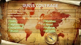
R N S S
Indian Regional Navigation Satellite System
CONTENTS
BACKGROUND
WHY LAUNCHED?
SATELLITE CONSTELLATION
SATELLITE GENERATIONS
ARCHITECTURE
IRNSS SIGNAL
IRNSS COVERAGE
REFERENCE FRAME
PERFORMANCE (IRNSS vs GPS)
SERVICES
BENEFITS
BACKGROUND
Approved by Government of India in May 2006
 The total cost of the project is expected to be US$209 million
In April 2010, it was reported that India plans to start launching satellites by the
end of 2011, at a rate of one satellite after every six months
This would have made the IRNSS functional by 2015, but program was delayed
The IRNSS signal has been released for evaluation in Sep 2014
OTHER SYSTEMS
• GPS(Global Positioning System)
• GLONASS(Global Navigation Satellite System)
• BeiDou-2
• Galileo
Why Launched?
Selective availability of GPS signal made it less effective and
reliable
Access to foreign government-controlled global navigation
satellite systems (GPS) is not guaranteed in hostile situations
Indian military depending on American GPS during Wars
SATELLITE CONSTELLATION
SATELLITE GENERATIONS
 IRNSS-1A was the first navigational satellite in the IRNSS series of satellites to be
placed in geosynchronous orbit. ( PSLV-C22on 1 July 2013 from the Satish Dhawan
Space Centre at Sriharikota).
ARCHITECTURE
The IRNSS architecture mainly consists of:
Space Segment
Ground Segment
User Segment
ARCHITECTURE
SPACE SEGMENT
 Based on various considerations the minimum number of
satellites required for IRNSS constellation is worked out to
be 7 (3 GEO and 4 GSO).
 The 3 GEOs will be located at 32.5º E, 83º E and 131.5º E and
the 4 GSOs have their longitude crossings 55º E and 111.75º
E (two in each plane).
GROUND SEGMENT
Ground Segment is responsible for the maintenance and operation of
the IRNSS constellation. The Ground segment comprises of:
 ISRO Navigation Centre
 IRNSS Spacecraft Control Facility
 IRNSS Range and Integrity Monitoring Stations
 IRNSS Network Timing Centre
 IRNSS CDMA Ranging Stations
 Laser Ranging Stations
 Data Communication Network
USER SEGMENT
The User segment mainly consists of:
 Single frequency IRNSS receiver capable of receiving SPS
signal at L5 or S band
 frequency
 A dual frequency IRNSS receiver capable of receiving both
L5 and S band frequencies.
 A receiver compatible to IRNSS and other GNSS signals
IRNSS SIGNAL PLAN
The first proposal for the Signal and Frequency Plan presented in Nov 2006
during the First ICG Meeting in Vienna by Indian Space Research Organization
(ISRO).
IRNSS COVERAGE
1,500-2,000 km’s around Indian land-mass SAARC countries can use IRNSS
navigation system
SAARC members countries included are
India
Afghanistan
Bangladesh
Bhutan
Maldives
 Nepal
Pakistan
Sri Lanka
IRNSS COVERAGE
IRNSS PERFORMANCE
Current status with 4 satellites of IRNSS, the GDOP
(Geometric Dilution of Precision varies from 2m to 9m in a day)
which means we are getting accuracy around 8m to 40m.
With 3 more satellites in IRNSS the GDOP variation would be
only 3-4m and hence accuracy will be guaranteed less than
20m throughout day in any part of India
Please note GPS is giving similar accuracy
IRNSS PERFORMANCE
IRNSS L5 signal is compatible with GPS new signal structure
of L5c. and hence user may have receiver with both GPS and
IRNSS and get better accuracy by combing solution.
IRNSS broadcast difference between IRNSS and GPS, IRNSS
and GLONASS for compatibility.
IRNSS VS OTHERS
SERVICES
Special Positioning Service (SPS) an open
service without encryption and Restricted
Service
Precision Service (PS) an authorized with
encryption are the basic services offered by
IRNSS
APPLICATIONS/BENEFITS
NAVIGATION
•Boats and ships
•Heavy Equipment
•Cyclists
•Air navigation
•Automobiles
•Hikers, climbers
APPLICATIONS/BENEFITS
SURVEYING & MAPPING
•Archaeology
•Geophysics and geology
•Surveying
•Mapping and geographic
information systems
APPLICATIONS/BENEFITS
OTHER USES
•Military Precision-guided munitions
•Mobile Satellite Communications
•GPS tracking
•Weather Prediction
•Skydiving
•Social Networking
CHALANGES
• Clock failure
• Theory of relativity
• Not global
REFERENCES
www.google.com
www.navipedia.net
www.isro.gov
www.wikipedia.org
www.nasa.gov
IRNSS

IRNSS