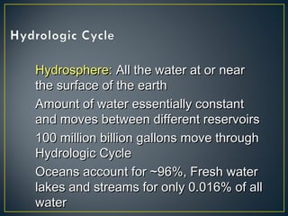
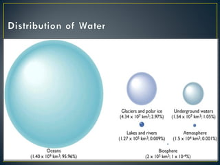
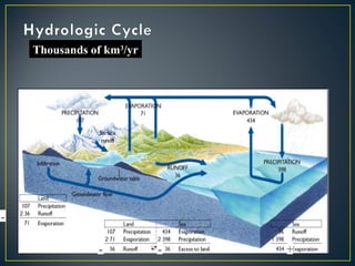
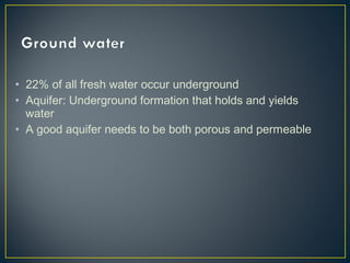
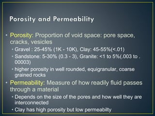
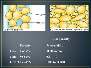
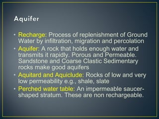
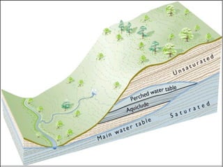
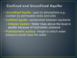
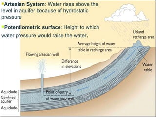
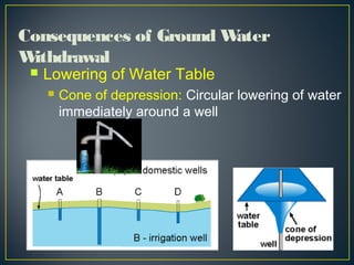
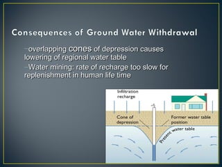
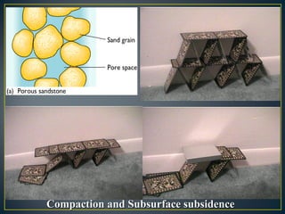
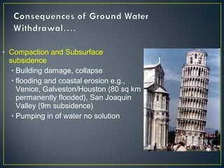
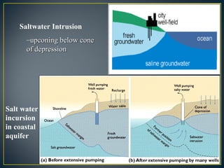
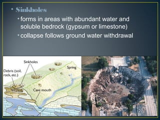
Dharmesh Mishra
130070106127
D - 2
Hydrosphere:Hydrosphere: All the water at or nearAll the water at or near
the surface of the earththe surface of the earth
Amount of water essentially constantAmount of water essentially constant
and moves between different reservoirsand moves between different reservoirs
100 million billion gallons move through100 million billion gallons move through
Hydrologic CycleHydrologic Cycle
Oceans account for ~96%, Fresh waterOceans account for ~96%, Fresh water
lakes and streams for only 0.016% of alllakes and streams for only 0.016% of all
waterwater
Thousands of km3
/yr
-
- - +
• 22% of all fresh water occur underground
• Aquifer: Underground formation that holds and yields
water
• A good aquifer needs to be both porous and permeable
• Porosity: Proportion of void space: pore space,
cracks, vesicles
• Gravel : 25-45% (1K - 10K), Clay: 45-55%(<.01)
• Sandstone: 5-30% (0.3 - 3), Granite: <1 to 5%(.003 to .
00003)
• higher porosity in well rounded, equigranular, coarse
grained rocks
• Permeability: Measure of how readily fluid passes
through a material
• Depends on the size of the pores and how well they are
interconnected
• Clay has high porosity but low permeabilty
Less porosity
Porosity Permeability
Clay 45-55% <0.01 m/day
Sand 30-52% 0.01 - 10
Gravel 25 - 45% 1000 to 10,000
• Zone of Aeration or
Vadose Zone or
Unsaturated Zone:
Overlies Phreatic Zone.
Pore spaces partly filled
with water. Contains soil
moisture.
Saturated
Zone
Zone of Saturation or Phreatic Zone:Zone of Saturation or Phreatic Zone: saturatedsaturated
zone overlying impermeable bed rock. Water fills allzone overlying impermeable bed rock. Water fills all
the available pore spacesthe available pore spaces
Water Table:Water Table: top of the zone of saturation wheretop of the zone of saturation where
not confined by impermeable rocknot confined by impermeable rock
• Water table follows the topography but more gently
• Intersection of water table and ground surface produces
lakes, streams, spring, wetlands…
• Ground water flows from higher elevation to lower, from
areas of lower use to higher use, from wet areas to dry
areas.
• Hydraulic Gradient: Slope of the ground water table
• Rate of flow is proportional to the hydraulic gradient
Q = Ki
Here,
Q = discharge
K = coefficient of
discharge
i = hydraulic gradient
• Recharge: Process of replenishment of Ground
Water by infiltration, migration and percolation
• Aquifer: A rock that holds enough water and
transmits it rapidly. Porous and Permeable.
Sandstone and Coarse Clastic Sedimentary
rocks make good aquifers
• Aquitard and Aquiclude: Rocks of low and very
low permeability e.g., shale, slate
• Perched water table: An impermeable saucer-
shaped stratum. These are non rechargeable.
• Unconfined Aquifer: open to atmosphere e.g.,
overlain by permeable rocks and soils
• Confined aquifer: sandwiched between aquitards
• Artesian System: Water rises above the level in
aquifer because of hydrostatic pressure
• Potentiometric surface: Height to which water
pressure would raise the water.
Artesian System: Water rises above the
level in aquifer because of hydrostatic
pressure
Potentiometric surface: Height to which
water pressure would raise the water.
 Lowering of Water Table
 Cone of depression: Circular lowering of water
immediately around a well
Consequences of Ground Water
Withdrawal
–overlappingoverlapping conescones of depression causesof depression causes
lowering of regional water tablelowering of regional water table
–Water mining: rate of recharge too slow forWater mining: rate of recharge too slow for
replenishment in human life timereplenishment in human life time
Compaction and Subsurface subsidenceCompaction and Subsurface subsidence
• Compaction and Subsurface
subsidence
• Building damage, collapse
• flooding and coastal erosion e.g.,
Venice, Galveston/Houston (80 sq km
permanently flooded), San Joaquin
Valley (9m subsidence)
• Pumping in of water no solution
Salt water
incursion
in coastal
aquifer
Saltwater Intrusion
–upconing below coneupconing below cone
of depressionof depression
• Sinkholes
• forms in areas with abundant water and
soluble bedrock (gypsum or limestone)
• collapse follows ground water withdrawal
• Loss of Recharge
• Impermeable cover retards recharge
• Filling of wetlands kills recharge area
• Well planned holding pond can help in
recharging ground water
• Most freshwater contain dissolved substances
• concentrations are described in ppm or ppb
• TDS=Total Dissolved Solids
• 500 to 1000 ppm for drinking water
• 2000 ppm for livestock
• some solids (e.g., Iron, Sulfur) more harmful than others
(e.g. calcium)
• synthetic chemicals can be toxic at ppb level
• Radioactive elements pose special hazard
• Uranium, Radium, Radon
• Hard Water:
• Common in limestone country
• contains dissolved Ca and Mg; problematic if >100
ppm
• problem with soap
• leaves deposits in plumbing and in appliances
• can be cured with water softener typically ion exchange
through zeolites
• Offstream Use: water diverted from source
e.g.,for irrigation or thermal power generation
• Consumptive: water used up
• For farming, drinking or lost by evaporation
• Instream: water returns to flow: e.g., for
hydroelectric power generation
• Main Uses:
• Thermoelectric Power
• Surface: Ground water = 67:33
• Consumed 2%, Return Flow 98%
• Irrigation
• Surface: Ground water = 63:33
• Consumed 56%, Loss 20%, Return Flow 24%
• Industrial
• Surface 67% (saline 12%), Ground water 15%
(1% saline), Public Supply 19%
• Consumption 15%, Return Flow 85%
• Domestic
• Public Supply 86%, Ground Water 13%, Surface
1%
• Consumption 23%, Return Flow 77%
• Thus, irrigation is the major consumer of ground
water
• Western states are the major drawers of ground
water causing serious environmental problems
• Rights :
• Every landowner can make reasonable use of lake or
stream or water flowing through or bordering his
property
• Municipalities have the right of eminent domain: at
times of scarcity, cities get their requirement first
• Sale of riparian rights allowed in some states
• Practical in regions of plentiful water
• Shift water-hungry crops to regions with more
rainfall
• Use drip irrigation to reduce evaporation loss
• Use pipes to reduce transport loss
• Water lawns in morning and evening or opt for
no lawn
• Direct storm water in recharge basins
Water resarch and ground water

Water resarch and ground water

  • 1.
  • 2.
    Hydrosphere:Hydrosphere: All thewater at or nearAll the water at or near the surface of the earththe surface of the earth Amount of water essentially constantAmount of water essentially constant and moves between different reservoirsand moves between different reservoirs 100 million billion gallons move through100 million billion gallons move through Hydrologic CycleHydrologic Cycle Oceans account for ~96%, Fresh waterOceans account for ~96%, Fresh water lakes and streams for only 0.016% of alllakes and streams for only 0.016% of all waterwater
  • 4.
  • 5.
    • 22% ofall fresh water occur underground • Aquifer: Underground formation that holds and yields water • A good aquifer needs to be both porous and permeable
  • 6.
    • Porosity: Proportionof void space: pore space, cracks, vesicles • Gravel : 25-45% (1K - 10K), Clay: 45-55%(<.01) • Sandstone: 5-30% (0.3 - 3), Granite: <1 to 5%(.003 to . 00003) • higher porosity in well rounded, equigranular, coarse grained rocks • Permeability: Measure of how readily fluid passes through a material • Depends on the size of the pores and how well they are interconnected • Clay has high porosity but low permeabilty
  • 7.
    Less porosity Porosity Permeability Clay45-55% <0.01 m/day Sand 30-52% 0.01 - 10 Gravel 25 - 45% 1000 to 10,000
  • 8.
    • Zone ofAeration or Vadose Zone or Unsaturated Zone: Overlies Phreatic Zone. Pore spaces partly filled with water. Contains soil moisture. Saturated Zone Zone of Saturation or Phreatic Zone:Zone of Saturation or Phreatic Zone: saturatedsaturated zone overlying impermeable bed rock. Water fills allzone overlying impermeable bed rock. Water fills all the available pore spacesthe available pore spaces Water Table:Water Table: top of the zone of saturation wheretop of the zone of saturation where not confined by impermeable rocknot confined by impermeable rock
  • 9.
    • Water tablefollows the topography but more gently • Intersection of water table and ground surface produces lakes, streams, spring, wetlands… • Ground water flows from higher elevation to lower, from areas of lower use to higher use, from wet areas to dry areas.
  • 10.
    • Hydraulic Gradient:Slope of the ground water table • Rate of flow is proportional to the hydraulic gradient Q = Ki Here, Q = discharge K = coefficient of discharge i = hydraulic gradient
  • 11.
    • Recharge: Processof replenishment of Ground Water by infiltration, migration and percolation • Aquifer: A rock that holds enough water and transmits it rapidly. Porous and Permeable. Sandstone and Coarse Clastic Sedimentary rocks make good aquifers • Aquitard and Aquiclude: Rocks of low and very low permeability e.g., shale, slate • Perched water table: An impermeable saucer- shaped stratum. These are non rechargeable.
  • 13.
    • Unconfined Aquifer:open to atmosphere e.g., overlain by permeable rocks and soils • Confined aquifer: sandwiched between aquitards • Artesian System: Water rises above the level in aquifer because of hydrostatic pressure • Potentiometric surface: Height to which water pressure would raise the water.
  • 14.
    Artesian System: Waterrises above the level in aquifer because of hydrostatic pressure Potentiometric surface: Height to which water pressure would raise the water.
  • 15.
     Lowering ofWater Table  Cone of depression: Circular lowering of water immediately around a well Consequences of Ground Water Withdrawal
  • 16.
    –overlappingoverlapping conescones ofdepression causesof depression causes lowering of regional water tablelowering of regional water table –Water mining: rate of recharge too slow forWater mining: rate of recharge too slow for replenishment in human life timereplenishment in human life time
  • 17.
    Compaction and SubsurfacesubsidenceCompaction and Subsurface subsidence
  • 18.
    • Compaction andSubsurface subsidence • Building damage, collapse • flooding and coastal erosion e.g., Venice, Galveston/Houston (80 sq km permanently flooded), San Joaquin Valley (9m subsidence) • Pumping in of water no solution
  • 19.
    Salt water incursion in coastal aquifer SaltwaterIntrusion –upconing below coneupconing below cone of depressionof depression
  • 20.
    • Sinkholes • formsin areas with abundant water and soluble bedrock (gypsum or limestone) • collapse follows ground water withdrawal
  • 21.
    • Loss ofRecharge • Impermeable cover retards recharge • Filling of wetlands kills recharge area • Well planned holding pond can help in recharging ground water
  • 22.
    • Most freshwatercontain dissolved substances • concentrations are described in ppm or ppb • TDS=Total Dissolved Solids • 500 to 1000 ppm for drinking water • 2000 ppm for livestock • some solids (e.g., Iron, Sulfur) more harmful than others (e.g. calcium) • synthetic chemicals can be toxic at ppb level • Radioactive elements pose special hazard • Uranium, Radium, Radon
  • 23.
    • Hard Water: •Common in limestone country • contains dissolved Ca and Mg; problematic if >100 ppm • problem with soap • leaves deposits in plumbing and in appliances • can be cured with water softener typically ion exchange through zeolites
  • 24.
    • Offstream Use:water diverted from source e.g.,for irrigation or thermal power generation • Consumptive: water used up • For farming, drinking or lost by evaporation • Instream: water returns to flow: e.g., for hydroelectric power generation
  • 25.
    • Main Uses: •Thermoelectric Power • Surface: Ground water = 67:33 • Consumed 2%, Return Flow 98% • Irrigation • Surface: Ground water = 63:33 • Consumed 56%, Loss 20%, Return Flow 24% • Industrial • Surface 67% (saline 12%), Ground water 15% (1% saline), Public Supply 19% • Consumption 15%, Return Flow 85% • Domestic • Public Supply 86%, Ground Water 13%, Surface 1% • Consumption 23%, Return Flow 77%
  • 26.
    • Thus, irrigationis the major consumer of ground water • Western states are the major drawers of ground water causing serious environmental problems
  • 27.
    • Rights : •Every landowner can make reasonable use of lake or stream or water flowing through or bordering his property • Municipalities have the right of eminent domain: at times of scarcity, cities get their requirement first • Sale of riparian rights allowed in some states • Practical in regions of plentiful water
  • 28.
    • Shift water-hungrycrops to regions with more rainfall • Use drip irrigation to reduce evaporation loss • Use pipes to reduce transport loss • Water lawns in morning and evening or opt for no lawn • Direct storm water in recharge basins