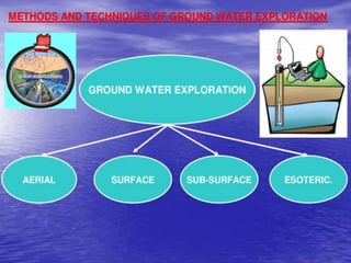
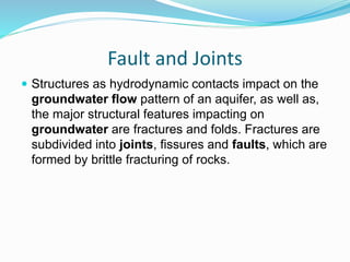
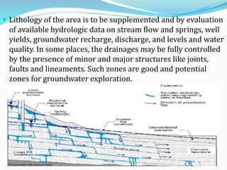
By
HEMANTH KUMAR N
DoS in Earth science
Applied Geology
Manasagangothri
Under the guidelines of
Prof. D Nagaraju.
Mysore university.
Contents
 Introduction.
 GROUND WATER EXPLORATION.
 OBJECTIVE OF GROUND WATER EXPLORATION.
 LITHOLOGICAL METHOD.
 ORIGIN OF GROUNDWATER.
 POROSITY and PERMEABILITY.
 LINEAMENT.
 FAULT and JOINTS.
 CONCLUSION.
Introduction
 Groundwater is an invisible natural resource. It is
available in different proportions, in various rock types
and at various depths, on the surface layer of the earth.
 More than 60 percent of the global population thrives
by using only the groundwater resources. The
groundwater which was existing at shallow depths in
the open wells, has gone deep due to over-
exploitation.
 Exploring these water sources become a challenging
task to geo-scientists.
GROUND WATER EXPLORATION
 Though the ground water resources are widely
distributed, Nature does not provide ground water at
the places of our choice.
 The occurrence and distribution of ground water
resources are confined to certain geological formations
and structures.
 The ground water at all locations may not be directly
used if the quality of water is poor.
 All these problems can be solved using proper
exploration techniques.
Exploring groundwater
 Identifying the location of its availability is a
challenging task.
 Exploration of groundwater requires a basic
understanding of its position in the subsurface
geological setup.
 Groundwater Exploration is attempted through either
by direct or indirect methods.
 Test drilling is the direct approach to find out the
resource. This is an expensive affair.
OBJECTIVE OF GROUND WATER
EXPLORATION
 Usually the ground water exploration projects
pass through the phase of regional surveys,
leading to detailed surveys and ultimately
resulting in the exploitation of ground water
by means of bore holes, wells.
 Surface methods
The surface methods are easy to operate and implement.
These require minimum facilities like topo-sheets,
maps, reports, some field measurements and
interpretations of data in the laboratories. The surface
methods of groundwater exploration include the
following:
–Geomorphologic methods
–Geological & structural Methods (Lithological method)
–Soil and Micro-Biological Methods
–Remote Sensing Techniques
–Surface Geophysical Methods
LITHOLOGICAL METHOD
 LITHOLOGY
The study of the general physical characteristics of rocks.
The general physical characteristics of a rock or the rocks
in a particular area.
 As we know that lithology is the study of rock or rocks
in particular area, so to understand the sub-surface
features we need to know study the surface features
(outcrop).
 The study of rocks in the area that include physical and
chemical characteristics.
 Origin of ground water is mainly through
 Precipitation
 Infiltration
 Recharge
 To exploit the ground water we need to understand
that the good water bearing rocks in the particular
area, the type of rock and their permeability and
porosity and also joints, lineaments and folded
structures of the rocks and rock beds.
Porosity and Permeability
 Porosity is a measure of how much of a rock is open
space. This space can be between grains or within
cracks or cavities of the rock.
 Permeability is a measure of the ease with which a
fluid (water in this case) can move through a porous
rock.
Range of permeability of various soils
Lineament
 Natural lineament can be generally defined as linear
feature on the earth surface visible on the map.
 Lineaments are the result of heterogeneity (anomaly)
of physical/chemical/biological properties underneath
(faults and fractures in the first place).
Fault and Joints
 Structures as hydrodynamic contacts impact on the
groundwater flow pattern of an aquifer, as well as,
the major structural features impacting on
groundwater are fractures and folds. Fractures are
subdivided into joints, fissures and faults, which are
formed by brittle fracturing of rocks.
 Lithology of the area is to be supplemented and by evaluation
of available hydrologic data on stream flow and springs, well
yields, groundwater recharge, discharge, and levels and water
quality. In some places, the drainages may be fully controlled
by the presence of minor and major structures like joints,
faults and lineaments. Such zones are good and potential
zones for groundwater exploration.
 Contact points between permeable water-bearing
strata overlying relatively impermeable strata usually
along the sides of valleys that cut across the interface
between different strata are suitable locations for
groundwater. Springs occurring on or near the base of
hillsides, valley slopes, and local scarps are indicators
of groundwater occurrence over hilly terrain.
 Dykes are good barriers for arresting the flow of
groundwater. Location of dykes and analyzing their dip
and strike help in selecting the groundwater potential
zones in the upstream side.
CONCLUSION.
 The lithological methods of groundwater exploration
is the basic method of exploration by studying the rock
features in a required area.
 By studying the lithology of the area we go for other
methods of exploration for to understand the
groundwater situation in the subsurface clearly.
THANK YOU

Ground water exploration

  • 1.
    By HEMANTH KUMAR N DoSin Earth science Applied Geology Manasagangothri Under the guidelines of Prof. D Nagaraju. Mysore university.
  • 2.
    Contents  Introduction.  GROUNDWATER EXPLORATION.  OBJECTIVE OF GROUND WATER EXPLORATION.  LITHOLOGICAL METHOD.  ORIGIN OF GROUNDWATER.  POROSITY and PERMEABILITY.  LINEAMENT.  FAULT and JOINTS.  CONCLUSION.
  • 3.
    Introduction  Groundwater isan invisible natural resource. It is available in different proportions, in various rock types and at various depths, on the surface layer of the earth.
  • 4.
     More than60 percent of the global population thrives by using only the groundwater resources. The groundwater which was existing at shallow depths in the open wells, has gone deep due to over- exploitation.  Exploring these water sources become a challenging task to geo-scientists.
  • 5.
    GROUND WATER EXPLORATION Though the ground water resources are widely distributed, Nature does not provide ground water at the places of our choice.  The occurrence and distribution of ground water resources are confined to certain geological formations and structures.  The ground water at all locations may not be directly used if the quality of water is poor.  All these problems can be solved using proper exploration techniques.
  • 6.
    Exploring groundwater  Identifyingthe location of its availability is a challenging task.  Exploration of groundwater requires a basic understanding of its position in the subsurface geological setup.  Groundwater Exploration is attempted through either by direct or indirect methods.  Test drilling is the direct approach to find out the resource. This is an expensive affair.
  • 7.
    OBJECTIVE OF GROUNDWATER EXPLORATION  Usually the ground water exploration projects pass through the phase of regional surveys, leading to detailed surveys and ultimately resulting in the exploitation of ground water by means of bore holes, wells.
  • 9.
     Surface methods Thesurface methods are easy to operate and implement. These require minimum facilities like topo-sheets, maps, reports, some field measurements and interpretations of data in the laboratories. The surface methods of groundwater exploration include the following: –Geomorphologic methods –Geological & structural Methods (Lithological method) –Soil and Micro-Biological Methods –Remote Sensing Techniques –Surface Geophysical Methods
  • 10.
    LITHOLOGICAL METHOD  LITHOLOGY Thestudy of the general physical characteristics of rocks. The general physical characteristics of a rock or the rocks in a particular area.
  • 11.
     As weknow that lithology is the study of rock or rocks in particular area, so to understand the sub-surface features we need to know study the surface features (outcrop).  The study of rocks in the area that include physical and chemical characteristics.
  • 12.
     Origin ofground water is mainly through  Precipitation  Infiltration  Recharge  To exploit the ground water we need to understand that the good water bearing rocks in the particular area, the type of rock and their permeability and porosity and also joints, lineaments and folded structures of the rocks and rock beds.
  • 13.
    Porosity and Permeability Porosity is a measure of how much of a rock is open space. This space can be between grains or within cracks or cavities of the rock.  Permeability is a measure of the ease with which a fluid (water in this case) can move through a porous rock.
  • 15.
    Range of permeabilityof various soils
  • 16.
    Lineament  Natural lineamentcan be generally defined as linear feature on the earth surface visible on the map.  Lineaments are the result of heterogeneity (anomaly) of physical/chemical/biological properties underneath (faults and fractures in the first place).
  • 17.
    Fault and Joints Structures as hydrodynamic contacts impact on the groundwater flow pattern of an aquifer, as well as, the major structural features impacting on groundwater are fractures and folds. Fractures are subdivided into joints, fissures and faults, which are formed by brittle fracturing of rocks.
  • 18.
     Lithology ofthe area is to be supplemented and by evaluation of available hydrologic data on stream flow and springs, well yields, groundwater recharge, discharge, and levels and water quality. In some places, the drainages may be fully controlled by the presence of minor and major structures like joints, faults and lineaments. Such zones are good and potential zones for groundwater exploration.
  • 19.
     Contact pointsbetween permeable water-bearing strata overlying relatively impermeable strata usually along the sides of valleys that cut across the interface between different strata are suitable locations for groundwater. Springs occurring on or near the base of hillsides, valley slopes, and local scarps are indicators of groundwater occurrence over hilly terrain.  Dykes are good barriers for arresting the flow of groundwater. Location of dykes and analyzing their dip and strike help in selecting the groundwater potential zones in the upstream side.
  • 20.
    CONCLUSION.  The lithologicalmethods of groundwater exploration is the basic method of exploration by studying the rock features in a required area.  By studying the lithology of the area we go for other methods of exploration for to understand the groundwater situation in the subsurface clearly.
  • 21.