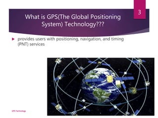
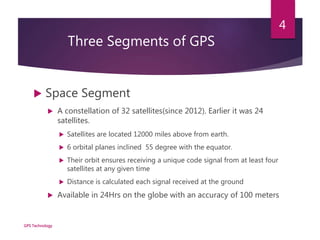
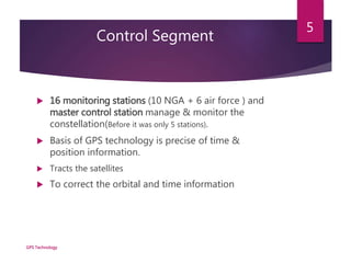
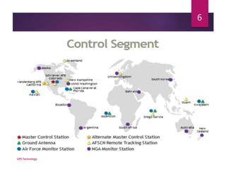
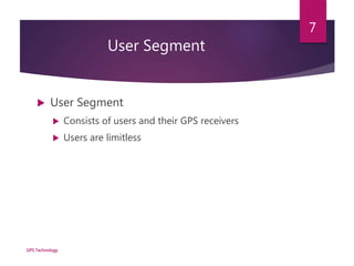
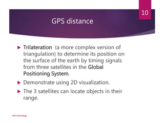
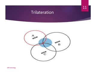
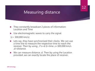
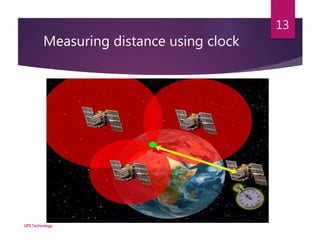
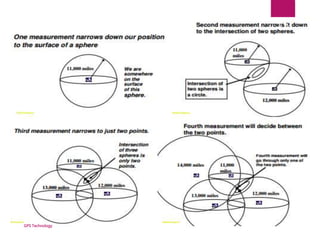
GPS Technology
CS302 PRESENTATION
Presented by
Abhishek B Jangid
Md Syed Ahamad
Nikhil Cherian
Md Rahul Islam
Reference
 Wikipedia
 Documentation:
 http://www.nhdfl.org/library/pdf/Forest%20Protection/Introduc
tion%20to%20Global%20Positioning%20System.pdf
 http://www.gps.gov/systems/gps/control/
GPS Technology
2
What is GPS(The Global Positioning
System) Technology???
 provides users with positioning, navigation, and timing
(PNT) services
GPS Technology
3
Three Segments of GPS
 Space Segment
 A constellation of 32 satellites(since 2012). Earlier it was 24
satellites.
 Satellites are located 12000 miles above from earth.
 6 orbital planes inclined 55 degree with the equator.
 Their orbit ensures receiving a unique code signal from at least four
satellites at any given time
 Distance is calculated each signal received at the ground
 Available in 24Hrs on the globe with an accuracy of 100 meters
GPS Technology
4
Control Segment
 16 monitoring stations (10 NGA + 6 air force ) and
master control station manage & monitor the
constellation(Before it was only 5 stations).
 Basis of GPS technology is precise of time &
position information.
 Tracts the satellites
 To correct the orbital and time information
GPS Technology
5
GPS Technology
6
User Segment
 User Segment
 Consists of users and their GPS receivers
 Users are limitless
GPS Technology
7
But Why Satellites??
GPS Technology
8
Idea!!
GPS Technology
9
•Effective for thousands of miles.
•Can be tracked with more accuracy.
GPS distance
 Trilateration (a more complex version of
triangulation) to determine its position on
the surface of the earth by timing signals
from three satellites in the Global
Positioning System.
 Demonstrate using 2D visualization.
 The 3 satellites can locate objects in their
range.
GPS Technology
10
Trilateration
GPS Technology
11
Measuring distance
 They constantly broadcast 2 pieces of information:
Location and Time
 Use electromagnetic waves to carry the signal.
(c= 300,000 km/s)
 Lets say ,they have synchronised their clocks. We can use
a time line to measure the respective time to reach the
receiver. Then by using , t*s=d (t=time ,s=300,000 km/s
,d=distance.
 We can measure distance ,d. Then by using the Location
provided ,we can exactly locate the place of receiver.
GPS Technology
12
Measuring distance using clock
GPS Technology
13
How GPS Works!
 The GPS receivers first download the orbital information
of all the satellites and stored it for future use
 Triangulation
 Once both satellite and position are known for at least
4 satellites, the receiver can determine a position by
triangulation.
GPS Technology
14
GPS Technology
15
GPS Errors
 User mistakes account for most GPS errors
 Satellite clock errors
 Orbit errors
 Ionospheric and Tropospheric interference
 Multipath interference, Selective availability, No. of
satellite visible, satellite geometry.
GPS Technology
16
Some GPS terminology
 2D Positioning
 There may be a substantial error in the horizontal coordinate
 3D Positioning
 More accuracy
GPS Technology
17
GPS Technology
18
THANK YOU

Gps technology presentation

  • 1.
    GPS Technology CS302 PRESENTATION Presentedby Abhishek B Jangid Md Syed Ahamad Nikhil Cherian Md Rahul Islam
  • 2.
    Reference  Wikipedia  Documentation: http://www.nhdfl.org/library/pdf/Forest%20Protection/Introduc tion%20to%20Global%20Positioning%20System.pdf  http://www.gps.gov/systems/gps/control/ GPS Technology 2
  • 3.
    What is GPS(TheGlobal Positioning System) Technology???  provides users with positioning, navigation, and timing (PNT) services GPS Technology 3
  • 4.
    Three Segments ofGPS  Space Segment  A constellation of 32 satellites(since 2012). Earlier it was 24 satellites.  Satellites are located 12000 miles above from earth.  6 orbital planes inclined 55 degree with the equator.  Their orbit ensures receiving a unique code signal from at least four satellites at any given time  Distance is calculated each signal received at the ground  Available in 24Hrs on the globe with an accuracy of 100 meters GPS Technology 4
  • 5.
    Control Segment  16monitoring stations (10 NGA + 6 air force ) and master control station manage & monitor the constellation(Before it was only 5 stations).  Basis of GPS technology is precise of time & position information.  Tracts the satellites  To correct the orbital and time information GPS Technology 5
  • 6.
  • 7.
    User Segment  UserSegment  Consists of users and their GPS receivers  Users are limitless GPS Technology 7
  • 8.
  • 9.
    Idea!! GPS Technology 9 •Effective forthousands of miles. •Can be tracked with more accuracy.
  • 10.
    GPS distance  Trilateration(a more complex version of triangulation) to determine its position on the surface of the earth by timing signals from three satellites in the Global Positioning System.  Demonstrate using 2D visualization.  The 3 satellites can locate objects in their range. GPS Technology 10
  • 11.
  • 12.
    Measuring distance  Theyconstantly broadcast 2 pieces of information: Location and Time  Use electromagnetic waves to carry the signal. (c= 300,000 km/s)  Lets say ,they have synchronised their clocks. We can use a time line to measure the respective time to reach the receiver. Then by using , t*s=d (t=time ,s=300,000 km/s ,d=distance.  We can measure distance ,d. Then by using the Location provided ,we can exactly locate the place of receiver. GPS Technology 12
  • 13.
    Measuring distance usingclock GPS Technology 13
  • 14.
    How GPS Works! The GPS receivers first download the orbital information of all the satellites and stored it for future use  Triangulation  Once both satellite and position are known for at least 4 satellites, the receiver can determine a position by triangulation. GPS Technology 14
  • 15.
  • 16.
    GPS Errors  Usermistakes account for most GPS errors  Satellite clock errors  Orbit errors  Ionospheric and Tropospheric interference  Multipath interference, Selective availability, No. of satellite visible, satellite geometry. GPS Technology 16
  • 17.
    Some GPS terminology 2D Positioning  There may be a substantial error in the horizontal coordinate  3D Positioning  More accuracy GPS Technology 17
  • 18.