Downloaded 218 times

![11 | P a g e
• The nominal GPS satellite constellation consists of 24 space
vehicles (SVs) distributed in six orbital planes with an
inclination of 55 degrees in relation to the equator. In
addition, the constellation has 3 backup satellites.
Basic functions of satellites-
1) To receive and store data transmitted by the control stations.
2) To maintain accurate time by means of several on-board
atomic clocks.
3) To transmit information and radio signals to users on two L
bands frequencies. L1-1575.42 MHz and L2-1227.60 MHz.
Another additional frequency, L5-1176.45 MHz will be use in
future.
4) To provide stable platform and orbit for the L band
transmitters.
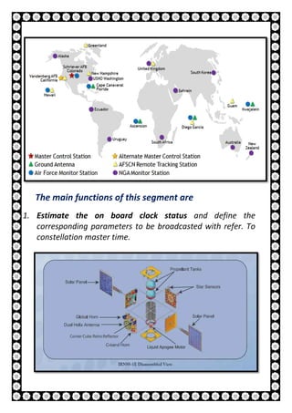
2. Control Segment
The GPS control Segment (also referred to as Ground
Segment or Operational Control System) is responsible for
the proper operation of the GPS system.
The GPS Control Segment is composed by a network of
[A] Monitor Stations (MS),
[B] A Master Control Station (MCS),
[C] A Backup of the MCS
[D] The Ground Antennas (GA)](https://image.slidesharecdn.com/jsrphyprojectpdfnew-180320091925/85/Project-on-GPS-Global-Positioning-System-11-320.jpg)


This document is a project report on the Global Positioning System (GPS) prepared by Jyotismat Raul for their physics department. The report contains 26 pages describing GPS, including its history, components, how it works, sources of error, applications for civilian and military use, advantages and disadvantages. It discusses the space, control and user segments, and how GPS determines position using signals from multiple satellites. Differential GPS is also explained as a method to improve accuracy.


!["GPS" Global Positioning System [PDF]](https://cdn.slidesharecdn.com/ss_thumbnails/globalpositioningsystemgpsmainpdf-101105164539-phpapp01-thumbnail.jpg?width=640&height=640&fit=bounds)


![GPS[Global Positioning System]](https://cdn.slidesharecdn.com/ss_thumbnails/globalpositioningsystem-130707095218-phpapp02-thumbnail.jpg?width=640&height=640&fit=bounds)


![Introduction to gps [compatibility mode]](https://cdn.slidesharecdn.com/ss_thumbnails/introductiontogpscompatibilitymode-131231040925-phpapp01-thumbnail.jpg?width=640&height=640&fit=bounds)