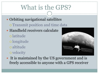
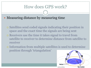
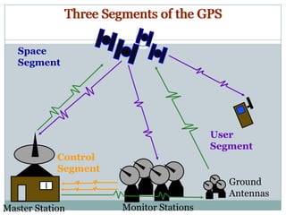
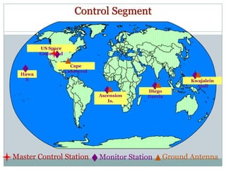
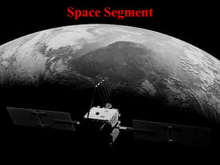
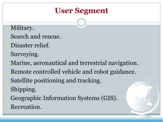
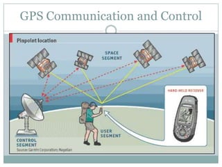
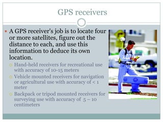
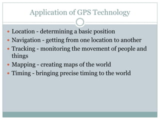
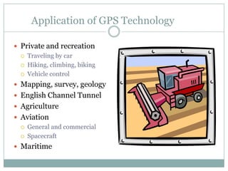
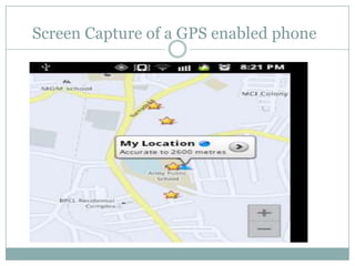
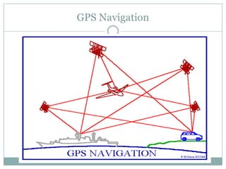
Global Positioning System
BY DHIREN PARYANI
0206CS111026
What is the GPS?
 Orbiting navigational satellites
 Transmit

position and time data
 Handheld receivers calculate
 latitude
 longitude
 altitude
 velocity
 It is maintained by the US government and is
freely accessible to anyone with a GPS receiver
History of the GPS
 1969—Defense Navigation Satellite System (DNSS)

formed
 1973—NAVSTAR Global Positioning System
developed
 1978—first 4 satellites launched
Delta rocket launch
History of the GPS
 1993—24th satellite

launched; initial
operational capability
 1995—full operational
capability
 May 2000—Military
accuracy available to
all users
How does GPS work?
 Measuring distance by measuring time

Satellites send coded signals indicating their position in
space and the exact time the signals are being sent
 Receivers use the time it takes signal to travel from
satellite to receiver to determine distance from satellite to
receiver
 Information from multiple satellites is used to determine
position through ‘triangulation’

Three Segments of the GPS
Space
Segment

User
Segment
Control
Segment
Ground
Antennas
Master Station

Monitor Stations
Control Segment

US Space
Command

Hawa
ii

Cape
Canaveral
Kwajalein
Atoll
Ascension
Is.

Master Control Station

Diego
Garcia

Monitor Station

Ground Antenna
Space Segment
User Segment
Military.
 Search and rescue.
 Disaster relief.
 Surveying.
 Marine, aeronautical and terrestrial navigation.
 Remote controlled vehicle and robot guidance.
 Satellite positioning and tracking.
 Shipping.
 Geographic Information Systems (GIS).
 Recreation.

GPS Communication and Control
GPS receivers
 A GPS receiver's job is to locate four

or more satellites, figure out the
distance to each, and use this
information to deduce its own
location.





Hand-held receivers for recreational use
with accuracy of 10-15 meters
Vehicle mounted receivers for navigation
or agricultural use with accuracy of < 1
meter
Backpack or tripod mounted receivers for
surveying use with accuracy of 5 – 10
centimeters
More about GPS receivers
 Receivers require clear line-of-sight; thus, they will

not work indoors or where tall objects obscure the
sky
Errors
 Troposphere causes delays in code and carrier

But they aren’t frequency dependent
But the errors are successfully modeled
 Errors due to Multipath
 Receiver noise
Errors
 Forces on the GPS satellite
 Earth is not a perfect sphere and hence uneven
gravitational potential distribution
 Other heavenly bodies attract the satellite, but these are
very well modeled
 Not a perfect vacuum hence drag but it is negligible at
GPS orbits
 Solar radiation effects which depends on the surface
reflectivity, luminosity of the sun, distance of to the sun.
this error is the largest unknown errors source
DGPS
 Errors in one position

are similar to a local
area
 High performance GPS
receiver at a known
location.
 Computes errors in the
satellite info
 Transmit this info in
RTCM-SC 104 format to
the remote GPS
Application of GPS Technology
 Location - determining a basic position
 Navigation - getting from one location to another
 Tracking - monitoring the movement of people and

things
 Mapping - creating maps of the world
 Timing - bringing precise timing to the world
Application of GPS Technology
 Private and recreation
 Traveling by car
 Hiking, climbing, biking
 Vehicle control
 Mapping, survey, geology
 English Channel Tunnel
 Agriculture
 Aviation
 General and commercial
 Spacecraft
 Maritime
Screen Capture of a GPS enabled phone
GPS Navigation
Any Queries?
Thank You!!

Global positioning system

  • 1.
    Global Positioning System BYDHIREN PARYANI 0206CS111026
  • 2.
    What is theGPS?  Orbiting navigational satellites  Transmit position and time data  Handheld receivers calculate  latitude  longitude  altitude  velocity  It is maintained by the US government and is freely accessible to anyone with a GPS receiver
  • 3.
    History of theGPS  1969—Defense Navigation Satellite System (DNSS) formed  1973—NAVSTAR Global Positioning System developed  1978—first 4 satellites launched Delta rocket launch
  • 4.
    History of theGPS  1993—24th satellite launched; initial operational capability  1995—full operational capability  May 2000—Military accuracy available to all users
  • 5.
    How does GPSwork?  Measuring distance by measuring time Satellites send coded signals indicating their position in space and the exact time the signals are being sent  Receivers use the time it takes signal to travel from satellite to receiver to determine distance from satellite to receiver  Information from multiple satellites is used to determine position through ‘triangulation’ 
  • 6.
    Three Segments ofthe GPS Space Segment User Segment Control Segment Ground Antennas Master Station Monitor Stations
  • 7.
  • 8.
  • 9.
    User Segment Military.  Searchand rescue.  Disaster relief.  Surveying.  Marine, aeronautical and terrestrial navigation.  Remote controlled vehicle and robot guidance.  Satellite positioning and tracking.  Shipping.  Geographic Information Systems (GIS).  Recreation. 
  • 10.
  • 11.
    GPS receivers  AGPS receiver's job is to locate four or more satellites, figure out the distance to each, and use this information to deduce its own location.    Hand-held receivers for recreational use with accuracy of 10-15 meters Vehicle mounted receivers for navigation or agricultural use with accuracy of < 1 meter Backpack or tripod mounted receivers for surveying use with accuracy of 5 – 10 centimeters
  • 12.
    More about GPSreceivers  Receivers require clear line-of-sight; thus, they will not work indoors or where tall objects obscure the sky
  • 13.
    Errors  Troposphere causesdelays in code and carrier But they aren’t frequency dependent But the errors are successfully modeled  Errors due to Multipath  Receiver noise
  • 14.
    Errors  Forces onthe GPS satellite  Earth is not a perfect sphere and hence uneven gravitational potential distribution  Other heavenly bodies attract the satellite, but these are very well modeled  Not a perfect vacuum hence drag but it is negligible at GPS orbits  Solar radiation effects which depends on the surface reflectivity, luminosity of the sun, distance of to the sun. this error is the largest unknown errors source
  • 15.
    DGPS  Errors inone position are similar to a local area  High performance GPS receiver at a known location.  Computes errors in the satellite info  Transmit this info in RTCM-SC 104 format to the remote GPS
  • 16.
    Application of GPSTechnology  Location - determining a basic position  Navigation - getting from one location to another  Tracking - monitoring the movement of people and things  Mapping - creating maps of the world  Timing - bringing precise timing to the world
  • 17.
    Application of GPSTechnology  Private and recreation  Traveling by car  Hiking, climbing, biking  Vehicle control  Mapping, survey, geology  English Channel Tunnel  Agriculture  Aviation  General and commercial  Spacecraft  Maritime
  • 18.
    Screen Capture ofa GPS enabled phone
  • 19.
  • 20.
  • 21.