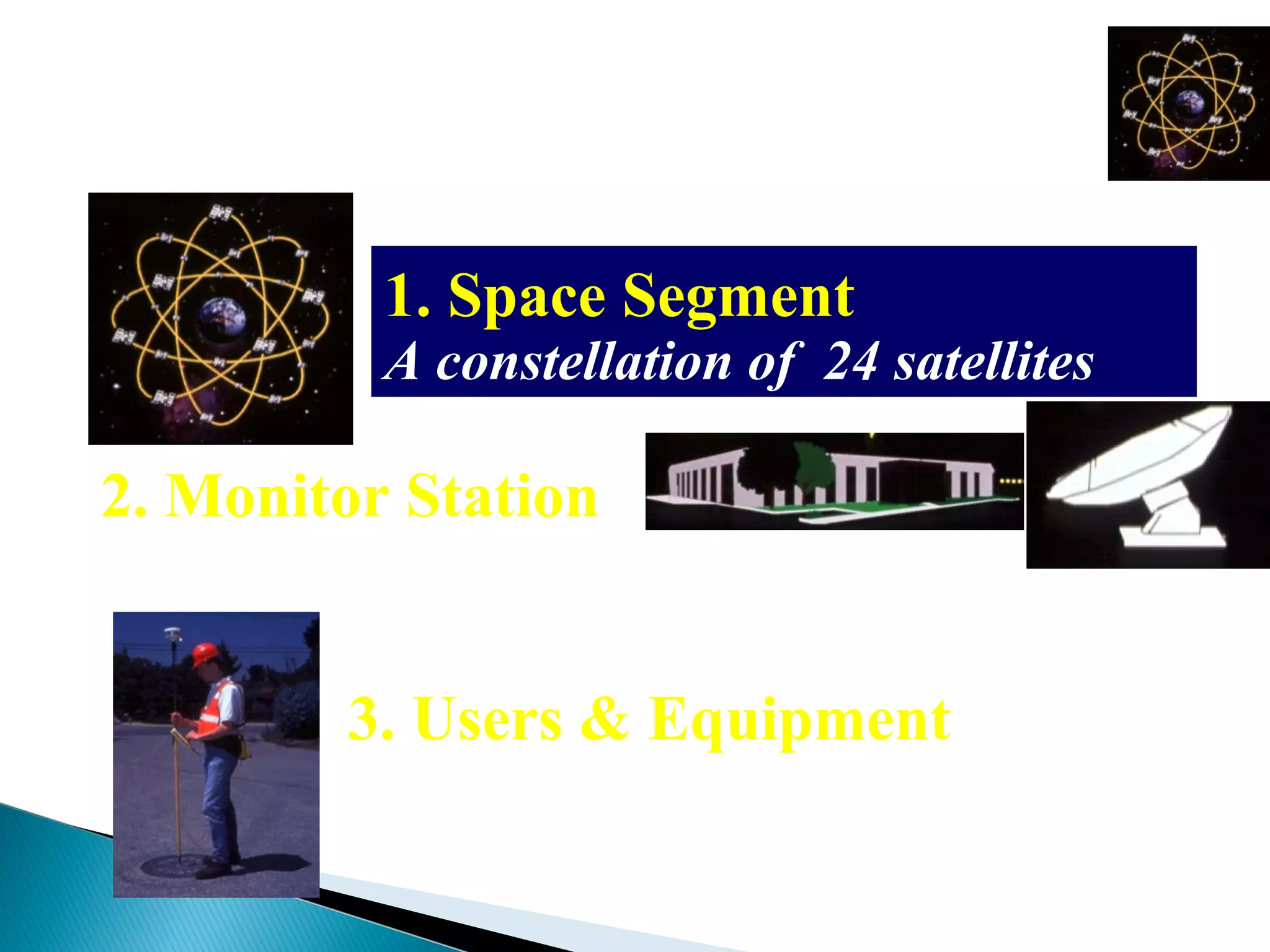
Global Positioning System
GPS
Dhaval A . Jalalpara
What is GPS ?
A very precise positioning system
• Developed and maintained by the
US Department of Defense (DOD)
• Satellite Based
* 24 satellites
* 20,200 km high orbit
 GPS stands for Global Positioning System which
measures 3-D locations on Earth surface using
satellites
 GPS operates using radio signals sent from satellites
orbiting the earth
 Created and Maintained by the US Dept. of Defense
 System as a whole consists of three segments
◦ Satellites (space segment)
◦ Receivers (user segment)
◦ Ground stations (control segment)
 At least 4 satellites are
above the horizon
anytime anywhere
 GPS satellites are also
known as “NAVSTAR
satellites”
 The satellites transmit
time according to very
accurate atomic clocks
onboard each one
 The precise positions of
satellites are known to
the GPS receivers from a
GPS almanac
Map from P. Dana, The Geographer's Craft Project, Dept. of Geography, U. Texas-Austin.
 Satellites have accurate atomic clocks
onboard and all GPS satellites transmit the
same time signal at the same time
◦ Think “synchronize your watches”
 The satellite signals contain information that
includes
◦ Satellite number
◦ Time of transmission
 Receivers use an almanac that includes
◦ The position of all satellites every second
◦ This is updated monthly from control stations
 The satellite signal is received, compared with the
receiver’s internal clock, and used to calculate the
distance from that satellite
 Trilateration (similar to triangulation) is used to
determine location from multiple satellite signals
 Satellite errors
◦ Satellite position error (i.e., satellite not exactly where it’s supposed to be)
◦ Atomic clocks, though very accurate, are not perfect
 Atmospheric
◦ Electro-magnetic waves travel at light speed only in a vacuum
◦ Atmospheric molecules, particularly those in the ionosphere, change the signal
speed
 Multi-path distortion
◦ The signal may "bounce" off structures before reaching the GPS receiver – the
reflected signal arrives a little later
 Receiver error:
◦ Due to the receiver clock or internal noise
 Selective Availability
◦ No longer an issue
Segments of GPS
1. Space Segment
A constellation of 24 satellites
2. Monitor Station
A network of earth-based facilities
3. Users & Equipment
Source:Trimble
GPS Receivers
 Differential correction collects points using a
receiver at a known location (known as a base
station) while you collect points in the field at the
same time (known as a rover receiver)
 Any errors in a GPS signal are likely to be almost
the same among all receivers within ~ 300 miles of
each other
~ 300 miles (~ 480 km) or less
Base station (known location) Rover receiver
Methods of data collection
Three methods of positioning
• Autonomous
10-20 meters
• Differential
2-5 meters
• Phase Differential
centimeter
2-5m10-20 m
cm
How accurate is GPS?
Depends on some variables
• Design of receiver
• Relative positions of satellites,
often known as DOP (Dilution of
Precision)
• Postprocessing
• Time spent on measurement
What is a PDOP?
• Position Dilution of Precision
Good PDOP Poor PDOP
GPS for Navigation
• Generating mapped data for GIS databases
• Collecting field data - travel to the field and capture
location & attribute information
• Other uses (many in real time):
• 911/firefighter/police/ambulance dispatch
• Car & boat navigation
• Roadside assistance
• Business vehicle/fleet management
• Mineral/resource exploration
• Wildlife tracking
• Recreational (fishing, hunting, hiking, etc.
• Ski patrol/medical staff location monitoring
 Easy To Incorporate into Project
 Once trained, just about anyone can use it
 Cheap
 Widely Available
 Does require a training component
 Accuracy Issues
 Differential Correction may not be an option in
many parts of the world
 Identify Your Accuracy Needs
 Identify Error Correction Methodology
◦ Point Averaging
 How long will points be collected?
◦ Differential Correction
 Find a base station
 Identify Point Collection Methodology
◦ Where will points be collected?
◦ Contingency plans
◦ Data backups
Global positioning system

Global positioning system

  • 1.
  • 2.
    What is GPS? A very precise positioning system • Developed and maintained by the US Department of Defense (DOD) • Satellite Based * 24 satellites * 20,200 km high orbit
  • 3.
     GPS standsfor Global Positioning System which measures 3-D locations on Earth surface using satellites  GPS operates using radio signals sent from satellites orbiting the earth  Created and Maintained by the US Dept. of Defense  System as a whole consists of three segments ◦ Satellites (space segment) ◦ Receivers (user segment) ◦ Ground stations (control segment)
  • 4.
     At least4 satellites are above the horizon anytime anywhere  GPS satellites are also known as “NAVSTAR satellites”  The satellites transmit time according to very accurate atomic clocks onboard each one  The precise positions of satellites are known to the GPS receivers from a GPS almanac Map from P. Dana, The Geographer's Craft Project, Dept. of Geography, U. Texas-Austin.
  • 5.
     Satellites haveaccurate atomic clocks onboard and all GPS satellites transmit the same time signal at the same time ◦ Think “synchronize your watches”  The satellite signals contain information that includes ◦ Satellite number ◦ Time of transmission
  • 6.
     Receivers usean almanac that includes ◦ The position of all satellites every second ◦ This is updated monthly from control stations  The satellite signal is received, compared with the receiver’s internal clock, and used to calculate the distance from that satellite  Trilateration (similar to triangulation) is used to determine location from multiple satellite signals
  • 7.
     Satellite errors ◦Satellite position error (i.e., satellite not exactly where it’s supposed to be) ◦ Atomic clocks, though very accurate, are not perfect  Atmospheric ◦ Electro-magnetic waves travel at light speed only in a vacuum ◦ Atmospheric molecules, particularly those in the ionosphere, change the signal speed  Multi-path distortion ◦ The signal may "bounce" off structures before reaching the GPS receiver – the reflected signal arrives a little later  Receiver error: ◦ Due to the receiver clock or internal noise  Selective Availability ◦ No longer an issue
  • 8.
    Segments of GPS 1.Space Segment A constellation of 24 satellites 2. Monitor Station A network of earth-based facilities 3. Users & Equipment Source:Trimble
  • 9.
  • 10.
     Differential correctioncollects points using a receiver at a known location (known as a base station) while you collect points in the field at the same time (known as a rover receiver)  Any errors in a GPS signal are likely to be almost the same among all receivers within ~ 300 miles of each other ~ 300 miles (~ 480 km) or less Base station (known location) Rover receiver
  • 11.
    Methods of datacollection Three methods of positioning • Autonomous 10-20 meters • Differential 2-5 meters • Phase Differential centimeter 2-5m10-20 m cm
  • 12.
    How accurate isGPS? Depends on some variables • Design of receiver • Relative positions of satellites, often known as DOP (Dilution of Precision) • Postprocessing • Time spent on measurement
  • 13.
    What is aPDOP? • Position Dilution of Precision Good PDOP Poor PDOP
  • 14.
  • 15.
    • Generating mappeddata for GIS databases • Collecting field data - travel to the field and capture location & attribute information • Other uses (many in real time): • 911/firefighter/police/ambulance dispatch • Car & boat navigation • Roadside assistance • Business vehicle/fleet management • Mineral/resource exploration • Wildlife tracking • Recreational (fishing, hunting, hiking, etc. • Ski patrol/medical staff location monitoring
  • 16.
     Easy ToIncorporate into Project  Once trained, just about anyone can use it  Cheap  Widely Available
  • 17.
     Does requirea training component  Accuracy Issues  Differential Correction may not be an option in many parts of the world
  • 18.
     Identify YourAccuracy Needs  Identify Error Correction Methodology ◦ Point Averaging  How long will points be collected? ◦ Differential Correction  Find a base station  Identify Point Collection Methodology ◦ Where will points be collected? ◦ Contingency plans ◦ Data backups

Editor's Notes

  • #3 At the cost of 15 billion dollar of your tax money
  • #6 Explain Triangulation
  • #7 Explain Triangulation