This document provides an overview of GPS (Global Positioning System), including its history, components, working principles, accuracy, signals, sources of errors, and methods to improve accuracy. GPS is a satellite-based navigation system consisting of 30+ satellites that transmits location and time information to GPS receivers. It became fully operational in 1995 and is maintained by the US government. The three segments are the space, control, and user segments. The working principle involves determining the location of GPS satellites and calculating distances to them using signal travel times. [END SUMMARY]
Jskkgkemgkdigieig
Re igkrkg
U
H
T
Rieogkskkfkfkeokdkdlwd
Feor. Eit eir r rid tnekt rb r r eir jekfkvkvind djcjejd bdicjebskjdbd skocck neb dkckcjcjjebd. Ksjsbd ekebenks d dndke. D dkdmm
Jskkgkemgkdigieig
Re igkrkg
U
H
T
Rieogkskkfkfkeokdkdlwd
Feor. Eit eir r rid tnekt rb r r eir jekfkvkvind djcjejd bdicjebskjdbd skocck neb dkckcjcjjebd. Ksjsbd ekebenks d dndke. D dkdmm
Brilliant Lecture delivered to me in Alagappa Engineering college Workshop.
The Global Positioning System (GPS) is a satellite
based radio navigation system provided by the
United States Department of Defence. It gives
unequaled accuracy and flexibility in positioning
for navigation, surveying and GIS data collection.
The global positioning system is a spaced based satelite navigation system that provides location time information in all weather conditions , anywhere on or near the earth where there is an unobstructed line of sight to four or more GPS satellites.
Developed and maintained by the US Department of Defense (DOD)
The Global Positioning System (GPS), originally Navstar GPS,[1][2] is a space-based radionavigation system owned by the United States government and operated by the United States Air Force. It is a global navigation satellite system that provides geolocation and time information to a GPS receiver anywhere on or near the Earth where there is an unobstructed line of sight to four or more GPS satellites
GPS is a satellite based radio navigation system which provides continuous, all weather, worldwide navigation capability for sea, land and air applications.
http://itspiders.net
Cosmetic shop management system project report.pdfKamal Acharya
Buying new cosmetic products is difficult. It can even be scary for those who have sensitive skin and are prone to skin trouble. The information needed to alleviate this problem is on the back of each product, but it's thought to interpret those ingredient lists unless you have a background in chemistry.
Instead of buying and hoping for the best, we can use data science to help us predict which products may be good fits for us. It includes various function programs to do the above mentioned tasks.
Data file handling has been effectively used in the program.
The automated cosmetic shop management system should deal with the automation of general workflow and administration process of the shop. The main processes of the system focus on customer's request where the system is able to search the most appropriate products and deliver it to the customers. It should help the employees to quickly identify the list of cosmetic product that have reached the minimum quantity and also keep a track of expired date for each cosmetic product. It should help the employees to find the rack number in which the product is placed.It is also Faster and more efficient way.
Hybrid optimization of pumped hydro system and solar- Engr. Abdul-Azeez.pdffxintegritypublishin
Advancements in technology unveil a myriad of electrical and electronic breakthroughs geared towards efficiently harnessing limited resources to meet human energy demands. The optimization of hybrid solar PV panels and pumped hydro energy supply systems plays a pivotal role in utilizing natural resources effectively. This initiative not only benefits humanity but also fosters environmental sustainability. The study investigated the design optimization of these hybrid systems, focusing on understanding solar radiation patterns, identifying geographical influences on solar radiation, formulating a mathematical model for system optimization, and determining the optimal configuration of PV panels and pumped hydro storage. Through a comparative analysis approach and eight weeks of data collection, the study addressed key research questions related to solar radiation patterns and optimal system design. The findings highlighted regions with heightened solar radiation levels, showcasing substantial potential for power generation and emphasizing the system's efficiency. Optimizing system design significantly boosted power generation, promoted renewable energy utilization, and enhanced energy storage capacity. The study underscored the benefits of optimizing hybrid solar PV panels and pumped hydro energy supply systems for sustainable energy usage. Optimizing the design of solar PV panels and pumped hydro energy supply systems as examined across diverse climatic conditions in a developing country, not only enhances power generation but also improves the integration of renewable energy sources and boosts energy storage capacities, particularly beneficial for less economically prosperous regions. Additionally, the study provides valuable insights for advancing energy research in economically viable areas. Recommendations included conducting site-specific assessments, utilizing advanced modeling tools, implementing regular maintenance protocols, and enhancing communication among system components.
Overview of the fundamental roles in Hydropower generation and the components involved in wider Electrical Engineering.
This paper presents the design and construction of hydroelectric dams from the hydrologist’s survey of the valley before construction, all aspects and involved disciplines, fluid dynamics, structural engineering, generation and mains frequency regulation to the very transmission of power through the network in the United Kingdom.
Author: Robbie Edward Sayers
Collaborators and co editors: Charlie Sims and Connor Healey.
(C) 2024 Robbie E. Sayers
Student information management system project report ii.pdfKamal Acharya
Our project explains about the student management. This project mainly explains the various actions related to student details. This project shows some ease in adding, editing and deleting the student details. It also provides a less time consuming process for viewing, adding, editing and deleting the marks of the students.
Water scarcity is the lack of fresh water resources to meet the standard water demand. There are two type of water scarcity. One is physical. The other is economic water scarcity.
CFD Simulation of By-pass Flow in a HRSG module by R&R Consult.pptxR&R Consult
CFD analysis is incredibly effective at solving mysteries and improving the performance of complex systems!
Here's a great example: At a large natural gas-fired power plant, where they use waste heat to generate steam and energy, they were puzzled that their boiler wasn't producing as much steam as expected.
R&R and Tetra Engineering Group Inc. were asked to solve the issue with reduced steam production.
An inspection had shown that a significant amount of hot flue gas was bypassing the boiler tubes, where the heat was supposed to be transferred.
R&R Consult conducted a CFD analysis, which revealed that 6.3% of the flue gas was bypassing the boiler tubes without transferring heat. The analysis also showed that the flue gas was instead being directed along the sides of the boiler and between the modules that were supposed to capture the heat. This was the cause of the reduced performance.
Based on our results, Tetra Engineering installed covering plates to reduce the bypass flow. This improved the boiler's performance and increased electricity production.
It is always satisfying when we can help solve complex challenges like this. Do your systems also need a check-up or optimization? Give us a call!
Work done in cooperation with James Malloy and David Moelling from Tetra Engineering.
More examples of our work https://www.r-r-consult.dk/en/cases-en/
Event Management System Vb Net Project Report.pdfKamal Acharya
In present era, the scopes of information technology growing with a very fast .We do not see any are untouched from this industry. The scope of information technology has become wider includes: Business and industry. Household Business, Communication, Education, Entertainment, Science, Medicine, Engineering, Distance Learning, Weather Forecasting. Carrier Searching and so on.
My project named “Event Management System” is software that store and maintained all events coordinated in college. It also helpful to print related reports. My project will help to record the events coordinated by faculties with their Name, Event subject, date & details in an efficient & effective ways.
In my system we have to make a system by which a user can record all events coordinated by a particular faculty. In our proposed system some more featured are added which differs it from the existing system such as security.
Quality defects in TMT Bars, Possible causes and Potential Solutions.PrashantGoswami42
Maintaining high-quality standards in the production of TMT bars is crucial for ensuring structural integrity in construction. Addressing common defects through careful monitoring, standardized processes, and advanced technology can significantly improve the quality of TMT bars. Continuous training and adherence to quality control measures will also play a pivotal role in minimizing these defects.
Forklift Classes Overview by Intella PartsIntella Parts
Discover the different forklift classes and their specific applications. Learn how to choose the right forklift for your needs to ensure safety, efficiency, and compliance in your operations.
For more technical information, visit our website https://intellaparts.com
Welcome to WIPAC Monthly the magazine brought to you by the LinkedIn Group Water Industry Process Automation & Control.
In this month's edition, along with this month's industry news to celebrate the 13 years since the group was created we have articles including
A case study of the used of Advanced Process Control at the Wastewater Treatment works at Lleida in Spain
A look back on an article on smart wastewater networks in order to see how the industry has measured up in the interim around the adoption of Digital Transformation in the Water Industry.
COLLEGE BUS MANAGEMENT SYSTEM PROJECT REPORT.pdfKamal Acharya
The College Bus Management system is completely developed by Visual Basic .NET Version. The application is connect with most secured database language MS SQL Server. The application is develop by using best combination of front-end and back-end languages. The application is totally design like flat user interface. This flat user interface is more attractive user interface in 2017. The application is gives more important to the system functionality. The application is to manage the student’s details, driver’s details, bus details, bus route details, bus fees details and more. The application has only one unit for admin. The admin can manage the entire application. The admin can login into the application by using username and password of the admin. The application is develop for big and small colleges. It is more user friendly for non-computer person. Even they can easily learn how to manage the application within hours. The application is more secure by the admin. The system will give an effective output for the VB.Net and SQL Server given as input to the system. The compiled java program given as input to the system, after scanning the program will generate different reports. The application generates the report for users. The admin can view and download the report of the data. The application deliver the excel format reports. Because, excel formatted reports is very easy to understand the income and expense of the college bus. This application is mainly develop for windows operating system users. In 2017, 73% of people enterprises are using windows operating system. So the application will easily install for all the windows operating system users. The application-developed size is very low. The application consumes very low space in disk. Therefore, the user can allocate very minimum local disk space for this application.
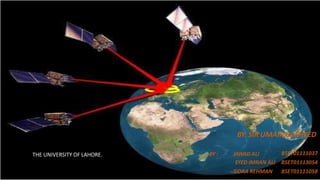
1. BY: SIR UMAIR RASHEED
BY : JAWAD ALI
SYED IMRAN ALI
SIDRA REHMAN
BSET01111037
BSET01113054
BSET01111058
THE UNIVERSITY OF LAHORE.
2. CONTENTS
• HISTORY.
• WHAT IS GPS?
• GPS ELEMENTS.
• HOW IT WORKS?
• GPS SIGNALS & FREQUENCIES.
• SOURCES OF GPS SIGNAL ERRORS.
• HOW TO IMPROVE THE ACCURACY OF GPS.
• LIMITATIONS.
• APPLICATIONS(VEHICLE TRACKING).
• FUTURE OF GPS.
• CONCLUSION.
3. HISTORY:
• Navigating by stars (requires clear nights and careful measurements)
most widely used for centuries
• The GPS project was developed in 1973 to overcome the limitations of previous
navigation systems.
• GPS was created and realized by the U.S. Department of Defense and was
originally run with 24 satellites.
• It became fully operational in 1995. “Bradford Parkinson”, “Roger L. Easton”, and
“Ivan A. Getting” are credited with inventing it.
4. WHAT IS GPS?
• GPS means
• A space-based satellite navigation system
provides location and time information in all weather.
• Maintained by the United States government and is freely accessible by anyone
with a GPS receiver.
5. OVERVEIW
• Official name : “Navigational Satellite Timing And Ranging Global Positioning
System” (NAVSTAR GPS)
• Consists of 30+ GPS satellites in medium Earth orbit (2000km - 35,000 km).
• Made up of two dozen satellites working in harmony are known as a satellite
constellation
• Mainly used for navigation, map-making and surveying.
Officiallogo for
NAVSTARGPS
6. GPS ELEMENTS.
Three segments
1. Space segment.
2. Control segment.
3. User segment.
Space Segment Control Segment
User Segment
7. SPACE SEGMENT
•GPS satellites fly in circular orbits at an altitude of 20,200 km and with a
period of 12 hours.
• Powered by solar cells.
• The satellites continuously orient themselves to point their solar panels toward the sun and their
antenna toward the earth.
• Orbital planes are centered on the Earth.
• Orbits are designed so that, at least, six satellites are always within line of sight from any location
on the planet.
8. CONTROL SEGMENT
• The CS consists of 3 entities:
• Master Control System
• Monitor Stations
• Ground Antennas
9. MASTER CONTROL STATION
The master control station, located at Falcon Air Force Base in Colorado
Springs,
Responsible for overall management of the remote monitoring and
transmission sites.
Check-up is performed twice a day, by each of 6 stations, as the satellites
complete their journeys around the earth.
Can reposition satellites to maintain an optimal GPS constellation.
10. MONITOR STATIONS
Falcon Air Force Base in Colorado,
Cape Canaveral,
Florida,
Hawaii,
Ascension Island in the Atlantic Ocean,
Diego Garcia Atoll in the Indian Ocean,
Kwajalein Island in the South Pacific Ocean.
• Checks the exact altitude, position, speed, and overall
health of the orbiting satellites.
• The control segment ensures that the GPS satellite orbits
and clocks remain within acceptable limits.
• A station can track up to 11 satellites at a time.
• This "check-up" is performed twice a day, by each
station.
11. GROUND ANTENNAS
• Ground antennas monitor and track the satellites from horizon to
horizon.
• They also transmit correction information to individual satellites.
• Communicate with the GPS satellites for command and control
purposes.
12. USER SEGMENT.
• GPS receivers are generally composed of
1. an antenna( tuned to the frequencies transmitted by the satellites),
2. receiver-processors, and
3. highly-stable clock( commonly a crystal oscillator).
• They can also include a display for showing location and speed information to the user.
• A receiver is often described by its number of channels ( this signifies how many satellites it can
monitor simultaneously).
• As of recent, receivers usually have between twelve and twenty channels.
13.
14. WORKING PRINCIPLE
Geometric Principle:
You can find one’s location if you know its distance from other,
already-known locations.
• Things which need to be determined:
• Current Locations of GPS Satellites.
• The Distance Between Receiver’s Position and the GPS Satellites.
15. CURRENT LOCATIONS OF GPS SATELLITES
• GPS satellites are orbiting the earth at an altitude of 11,000 miles.
• The orbits, and the locations of the satellites, are known in
advance.
• GPS receivers store this orbit information for all of the GPS
satellites in an ALMANAC*.
* The Almanac is a file which contains positional information for all of the GPS satellites
16. DISTANCE B/W RECEIVER’S POSITION AND GPS SATELLITES.
A GPS receiver can tell its own position by using the position data of itself, and compares
that data with 3 or more GPS satellites.
To get the distance to each satellite,
• By measuring the amount of time taken by radio signal (the GPS signal) to travel from the
satellite to the receiver.
• Radio waves travel at the speed of light, i.e. about 186,000 miles per second.
• The distance from the satellite to the receiver can be determined by the formula “distance =
speed x time”.
• Hence receiver’s position find out using trilateration.
17. •Distance measurements from two satellites limits
our location to the intersection of two spheres,
which is a circle.
20. ACCURACY
• The position calculated by a GPS receiver relies on three accurate
measurements:
• Current time
• Position of the satellite
• Time delay for the signal
• The GPS signal in space will provide a "worst case" accuracy of
7.8 meters at a 95% confidence level.
• GPS time is accurate to about 14 nanoseconds.
• Higher accuracy is available today by using GPS in combination with
augmentation systems. These enable real-time positioning to within a
few centimeters.
23. FREQUENCY INFORMATION
• The C/A code is transmitted on the L1 frequency.
• The Precision-code is transmitted on both the L1 and L2 frequencies.
• L3 is used by the Defense Support Program to signal detection of missile
launches, nuclear detonations, and other applications.
• L4 is used for additional correction to the part of the atmosphere that is
ionized by solar radiation.
• L5 is used as a civilian safety-of-life signal.
24. FREQUENCY L2C
• Launched in 2005, L2C is civilian GPS signal, designed specifically to meet
commercial needs.
• L2C enables ionospheric correction, a technique that boosts accuracy.
• Delivers faster signal acquisition, enhanced reliability, and greater
operating range.
• L2C broadcasts at a higher effective power making it easier to receive
under trees and even indoors.
25. SOURCES OF GPS SIGNAL ERRORS.
• Different errors can cause a deviation of +/- 50 -100 meters from the actual GPS receiver
position which are :
• 1.Satellite clock :
• Onenanosecondof inaccuracyin asatellite clockresultsin about30cm
• (1foot) oferrorin measuringthe distance tothat satellite.
• 2.Receiver clock :
• Anyerrorin the receiver clockcausesinaccuracyin distance measurement.
Howeverit is notpracticalto equipreceiverwithvery accurate atomicclocks.Atomicclocksweighmore
than20kgs, cost about US$50,000.
3.GPS Jamming :
• It limits the effectiveness of the GPS signal.
• GPS jammer is a low cost device to temporarily disable the reception of the civilian coarse
acquisition (C/A) code.
•
26. 3. Atmospheric errors
• Speed of GPS signal is affected by ionosphere &
troposphere.
• Which cause a deviation of 0 to 30 m. from the
actual position of receiver.
.
4.Multi-path error :
• Bouncing of GPS signal due to a reflecting surface before reaching to receiver antenna.
• Which cause a deviation of 0 to 1 m. from the actual position of receiver.
27. METHODS OF IMPROVING ACCURACY.
• Precision monitoring
–Dual Frequency Monitoring
–Carrier-Phase Enhancement (CPGPS)
–Relative Kinematic Positioning (RKP)
• Augmentation
28. A. Dual Frequency Monitoring.
• Refers to systems that can compare two or more signals.
• These two frequencies are affected in two different ways.
• After monitoring these signals, it’s possible to calculate what the error is and
eliminate it.
• Receivers that have the correct decryption key can decode the P(Y)-code
transmitted on signals to measure the error.
B. Carrier-Phase Enhancement (CPGPS)
• CPGPS uses the L1 carrier wave, which has a period 1000 times smaller than that
of the C/A bit period, to act as an additional clock signal and resolve uncertainty.
• The phase difference error in the normal GPS amounts to between 2 and 3
meters (6 to 10 ft) of ambiguity.
• CPGPS works to within 1% of perfect transition to reduce the error to 3
centimeters (1 inch) of ambiguity.
• By eliminating this source of error, CPGPS coupled with DGPS normally realizes
between 20 and 30 centimeters (8 to 12 inches) of absolute accuracy.
29. C. Relative Kinematic Positioning (RKP)
• Determination of range signal can be resolved to an accuracy of less than 10
centimeters (4 in).
• Resolves the number of cycles in which the signal is transmitted and received by the
receiver.
• Accomplished by using a combination of DGPS correction data, transmitting GPS signal
phase information and ambiguity resolution techniques via statistical tests — possibly
with processing in real-time.
Augmentation
• Relies on external information being integrated into the calculation process.
• Some augmentation systems transmit additional information about sources of error.
• Some provide direct measurements of how much the signal was off in the past
• Another group could provide additional navigational or vehicle information to be integrated
in the calculation process.
30. AUGMENTATION SYSTEM.
Nationwide Differential GPS System (NDGPS)
• Ground-based augmentation system that provides increased accuracy and integrity of GPS
information to users on U.S. land and waterways.
• The system consists of the Maritime Differential GPS System operated by the U.S. Coast
Guard and an inland component funded by the Department of Transportation.
Wide Area Augmentation System (WAAS)
• Satellite-based augmentation system operated by the Federal Aviation Administration (FAA),
supports aircraft navigation across North America.
31. • Global Differential GPS (GDGPS)
• High accuracy GPS augmentation system, developed by the NASA Jet
Propulsion Laboratory (JPL) to support the real-time positioning, timing, and
determination requirements of NASA science missions.
• Future NASA plans include using the Tracking and Data Relay Satellite System
(TDRSS) to transmit via satellite a real-time differential correction message.
32. LIMITATIONS
• GPS can provide worldwide, three-dimensional positions, 24 hours a day, in
any type of weather.
• But, There must be a relatively clear "line of sight" between the GPS
antenna and four or more satellites.
• Hence it becomes too difficult to ensure reliable positioning. These
difficulties are particularly prevalent in urban areas.
• The GPS signal may bounce off nearby objects causing another problem
called multi path interference.
33. APPLICATIONS
Surveying: Surveyors use absolute locations
to make maps and determine property
boundaries.
Telematics: GPS technology integrated with
computers and mobile communications
technology in automotive navigation systems.
39. APPLICATIONS- MILITARY
• GPS integrated into fighters, tankers, helicopters, ships, submarines,
tanks, jeeps, and soldiers' equipment.
• Target tracking.
• Search and rescue.
40. CONCLUSION.
• GPS, a satellite based navigation system, thus can be used to determine the position of
an object on earth.
• Its application field is vast and new applications will continue to be created as the
technology evolves.
• GPS can also interfaced with other similar projects such EU’s GALILEO to account for
unpredictable applications.
• Thus, the GPS constellation, like manmade stars in the sky, can be used for guiding and
navigation.