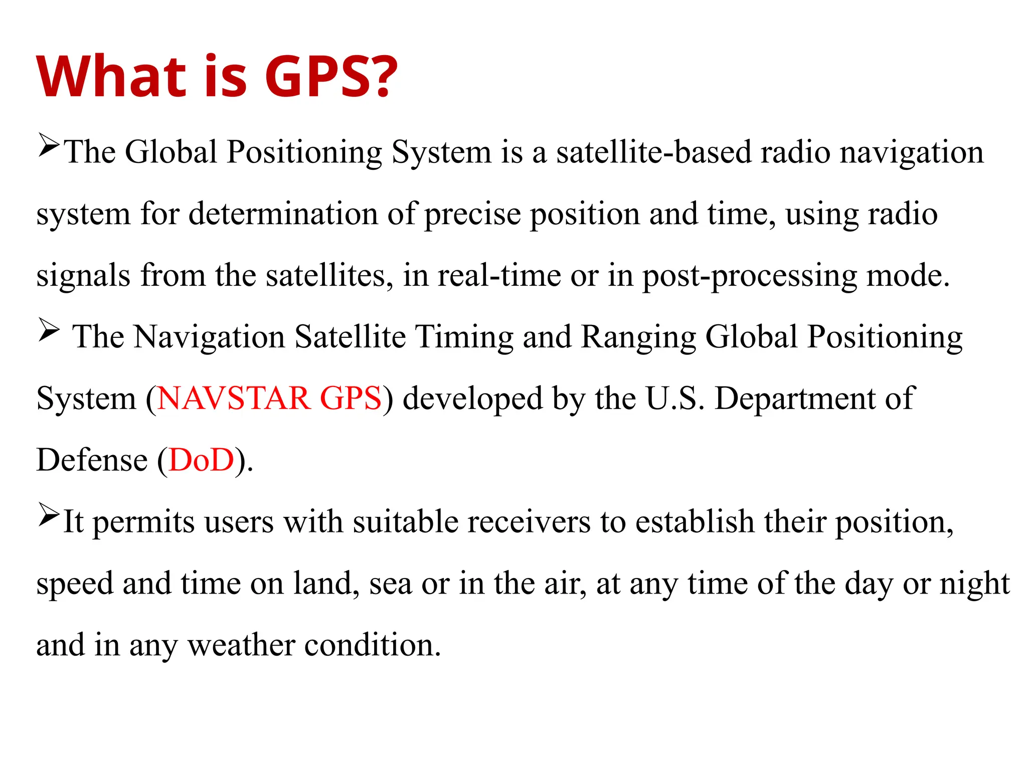
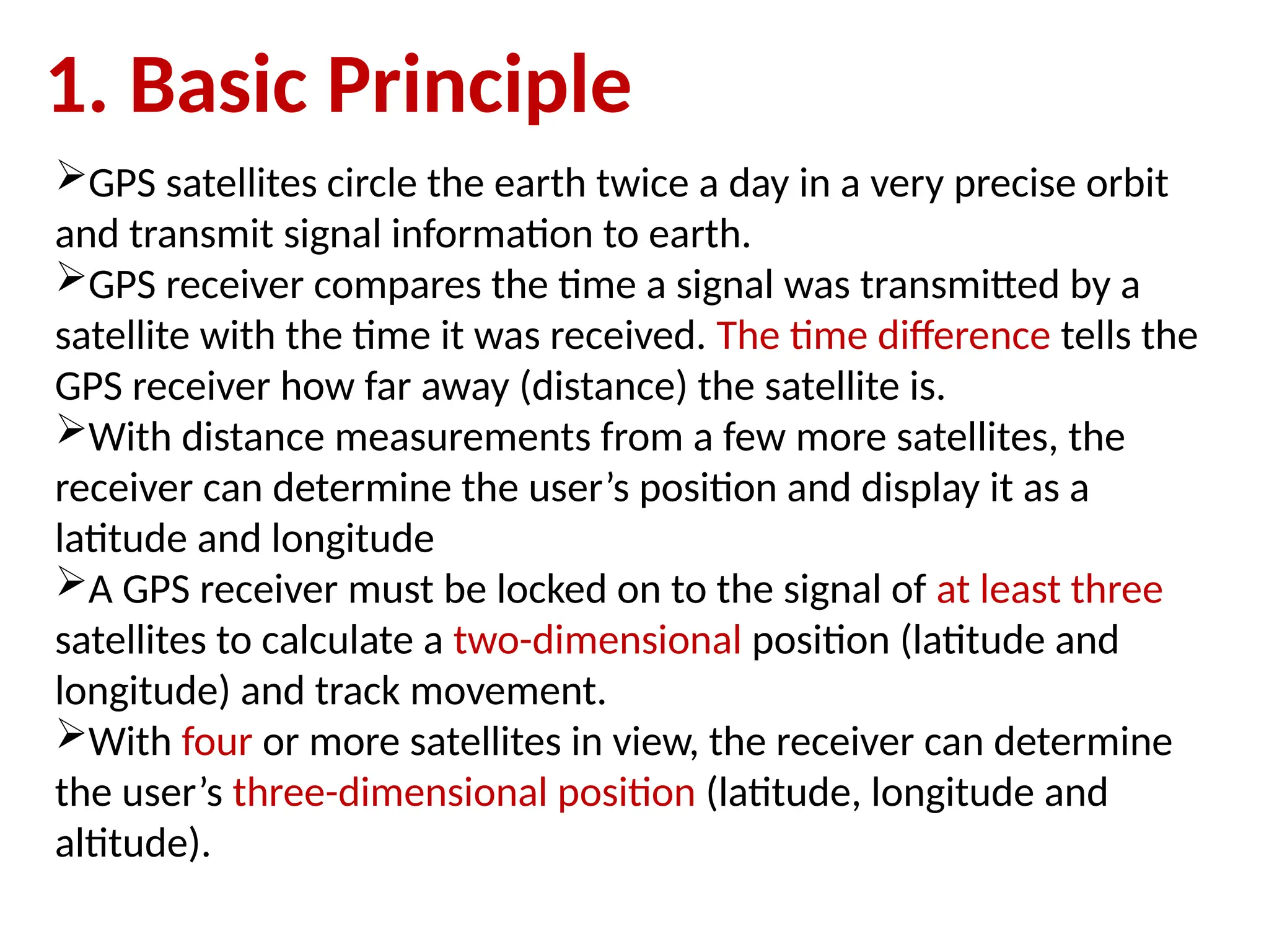
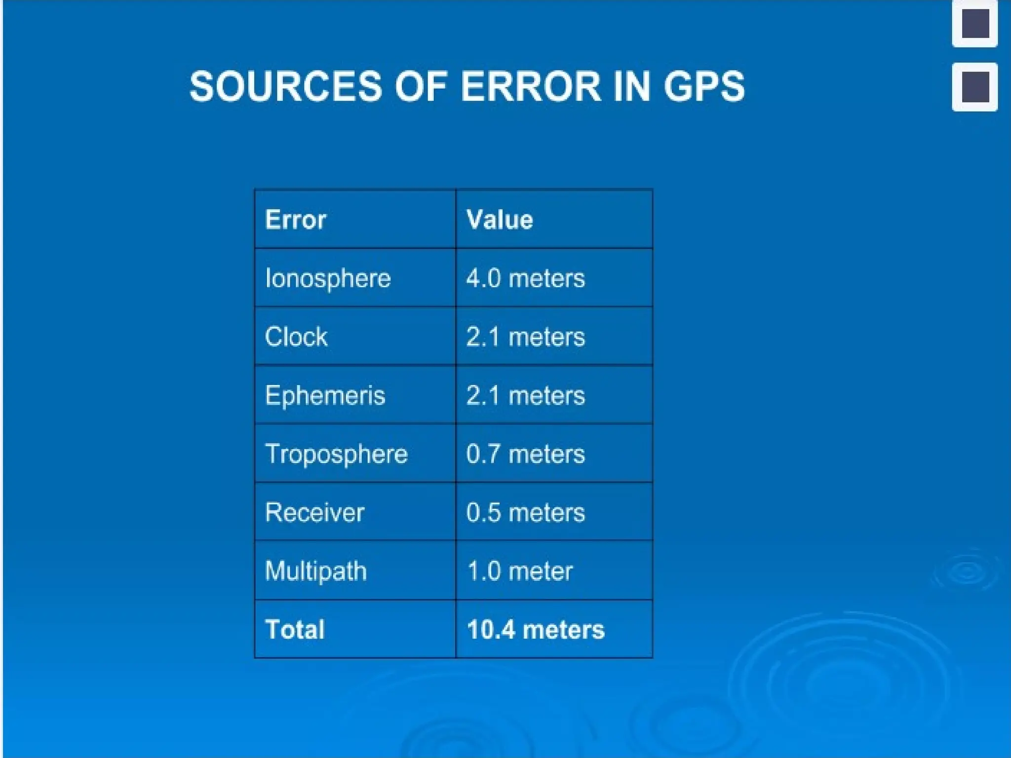
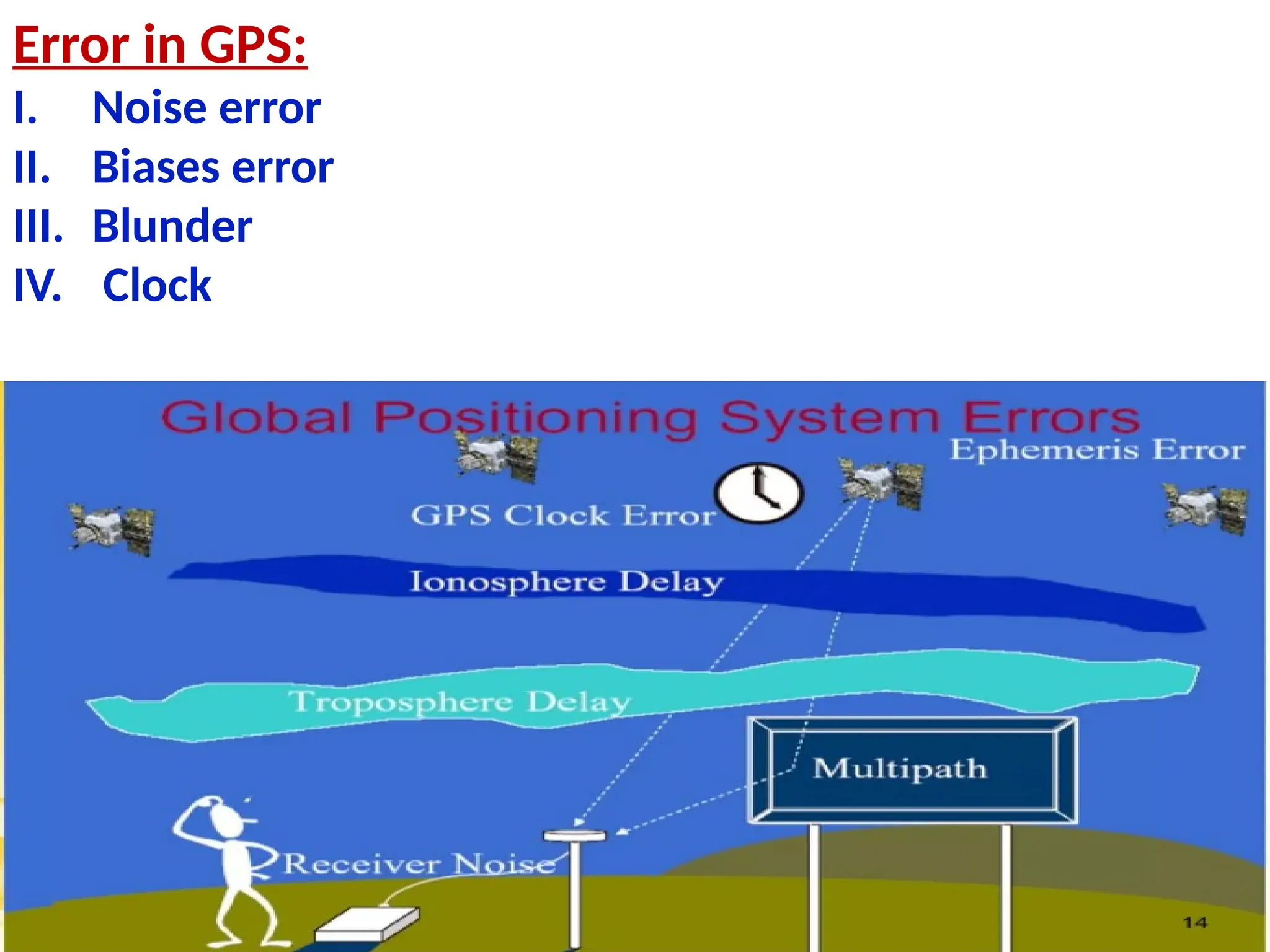
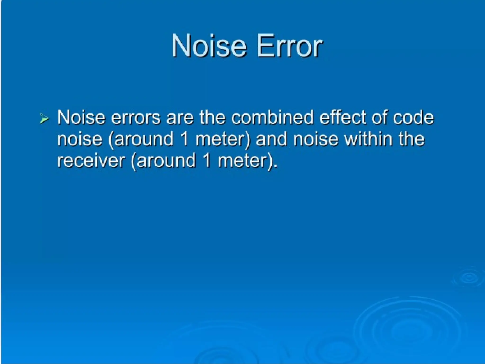
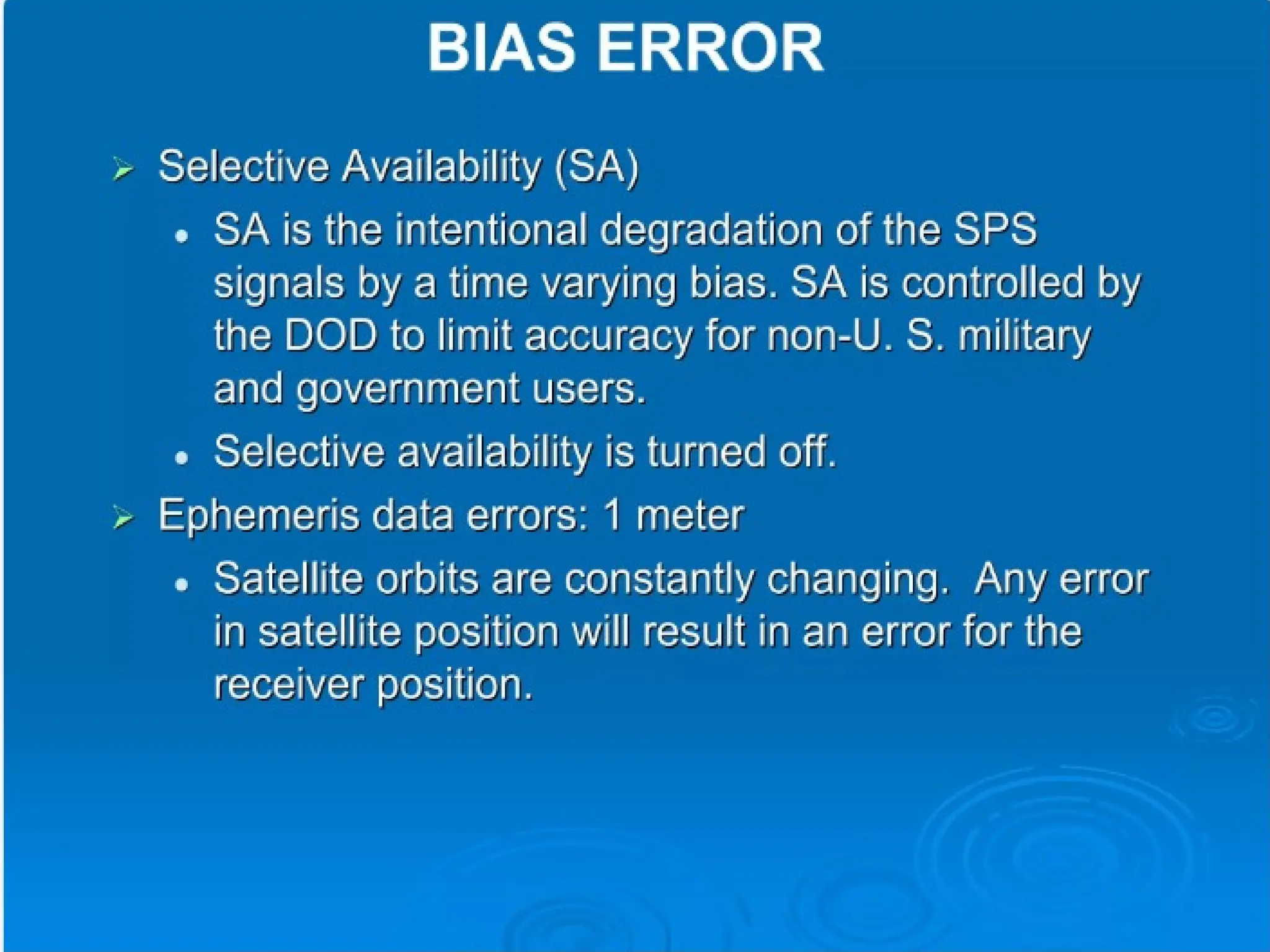
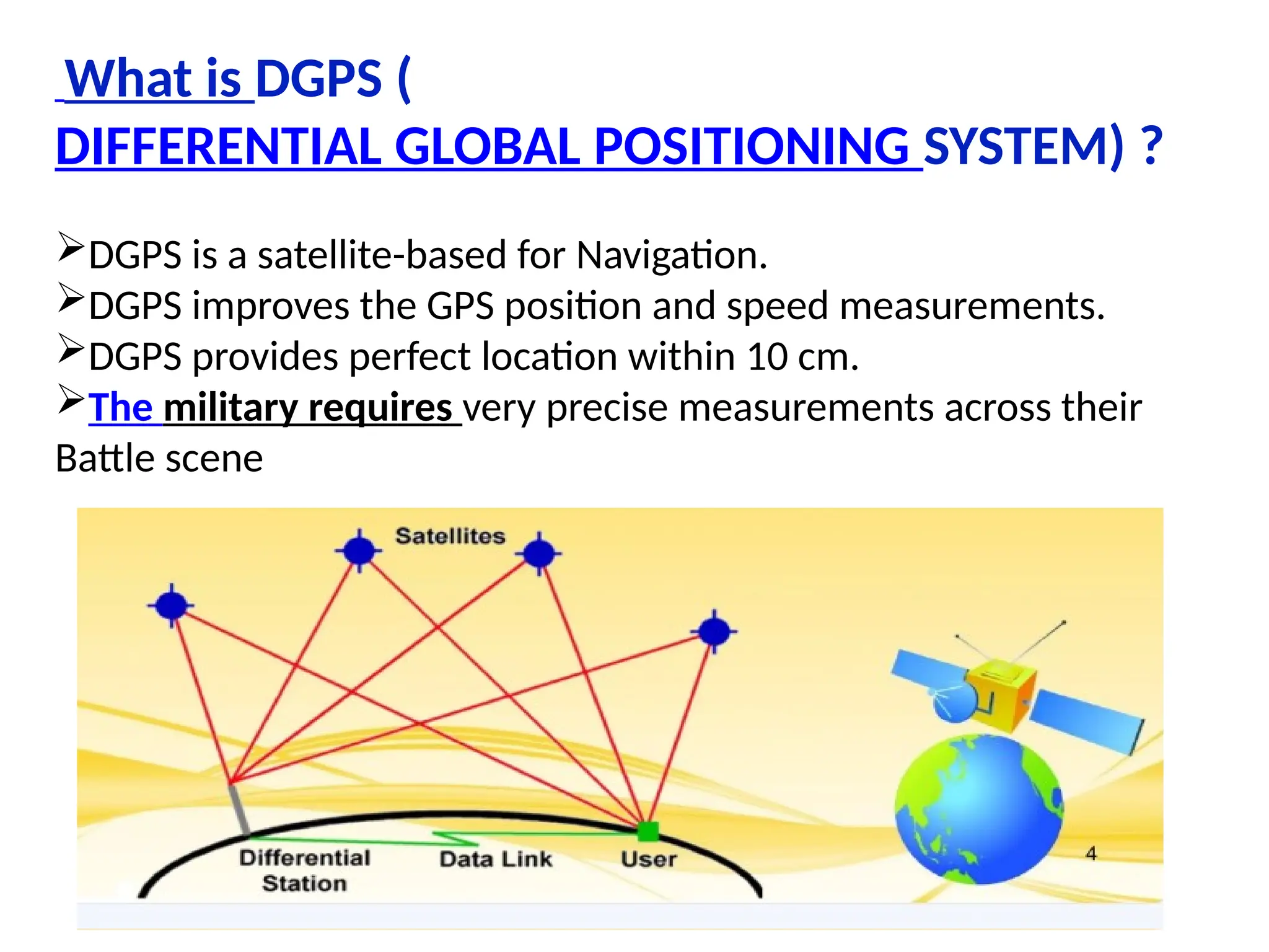
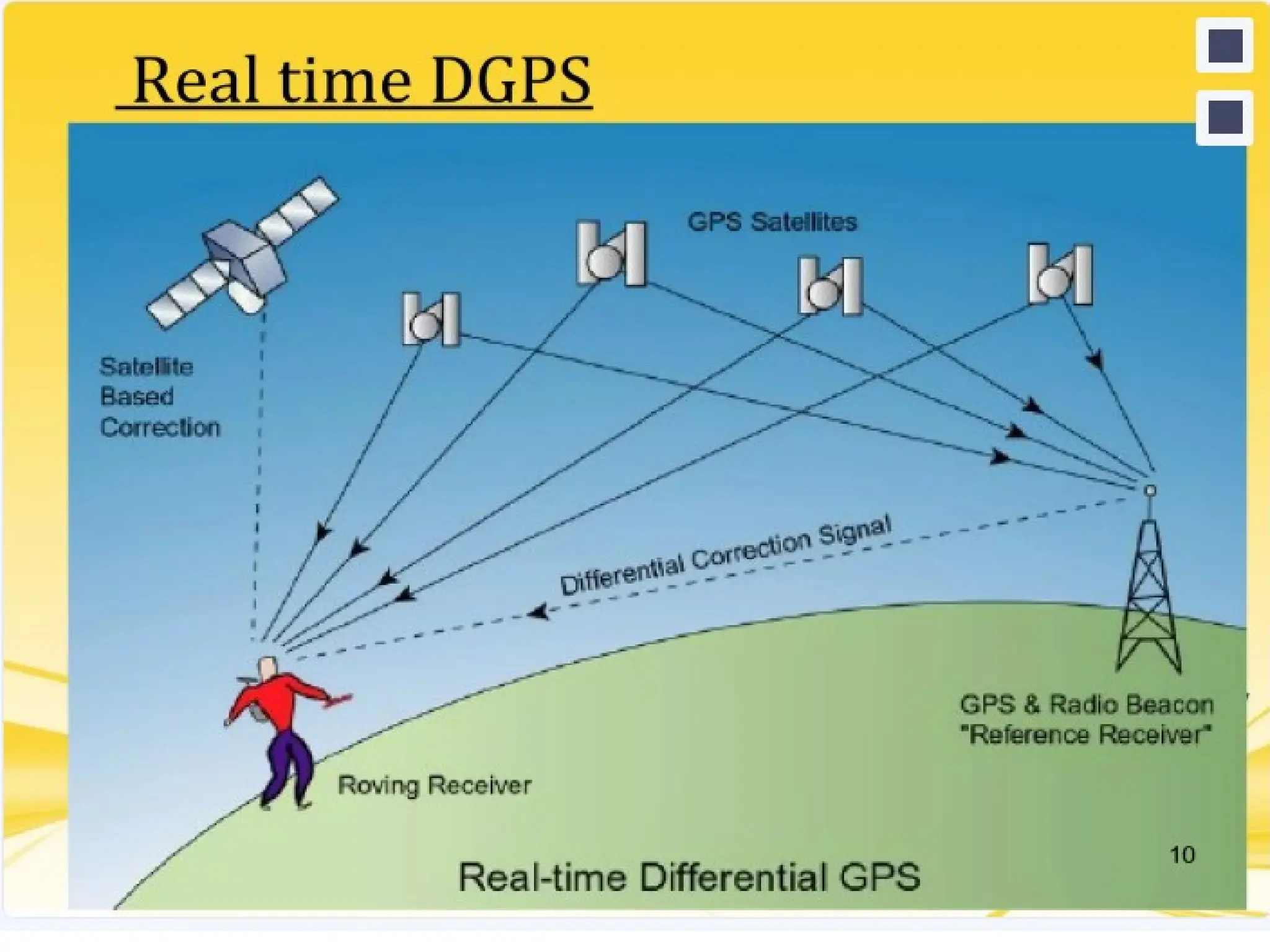
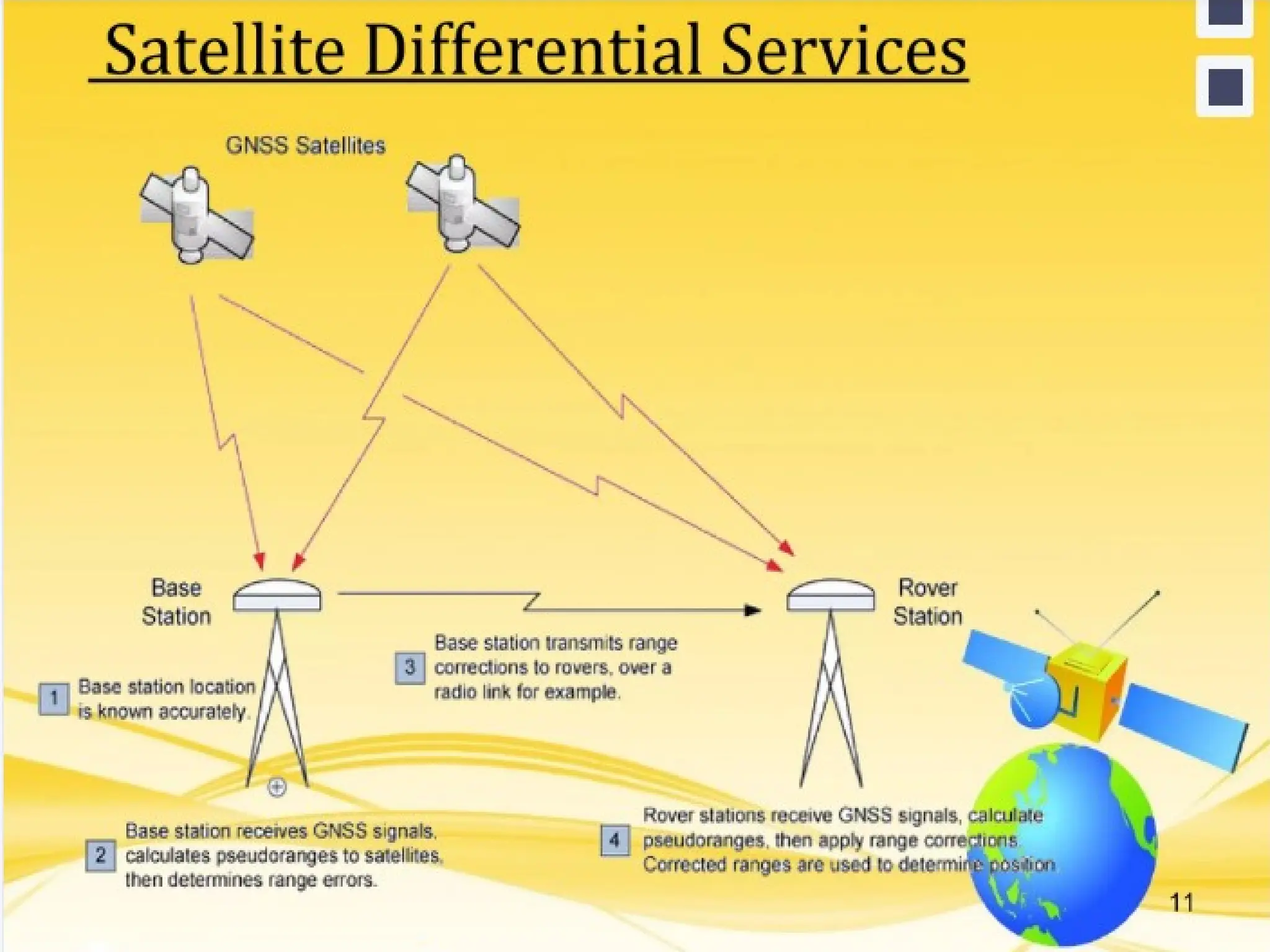
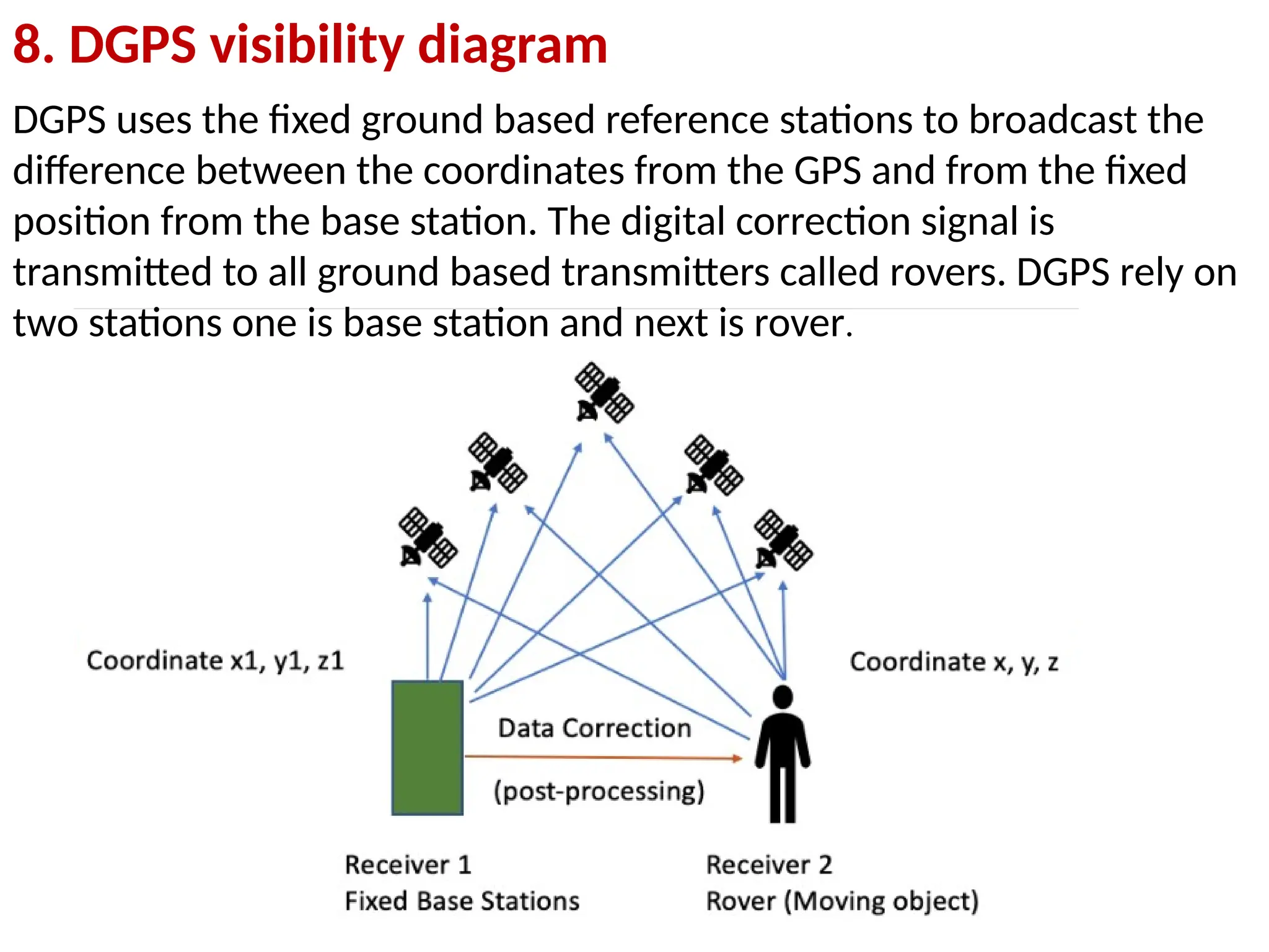
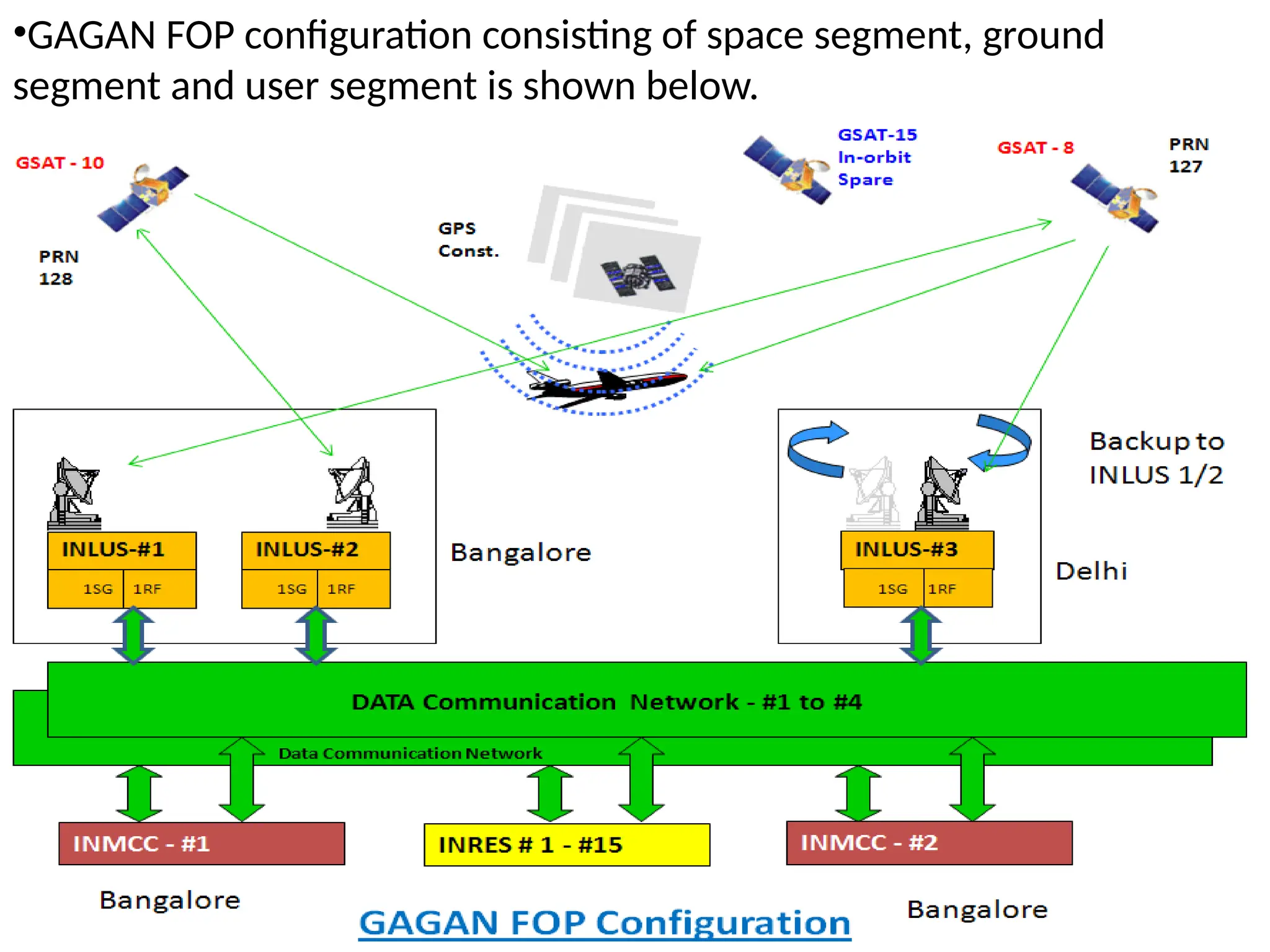
MODULE –V
GPS
GPS Basics
1. System overview-working principle of GPS
2. Satellite ranging
3. Calculating position
4. Ranging errors and its correction
5. GPS surveying Methods-static, Rapid static
6. DGPS and Kinematic methods
7. Real time and post processing
8. DGPS visibility diagram
9. GAGAN
Syllabus
What is GPS?
The Global Positioning System is a satellite-based radio navigation
system for determination of precise position and time, using radio
signals from the satellites, in real-time or in post-processing mode.
 The Navigation Satellite Timing and Ranging Global Positioning
System (NAVSTAR GPS) developed by the U.S. Department of
Defense (DoD).
It permits users with suitable receivers to establish their position,
speed and time on land, sea or in the air, at any time of the day or night
and in any weather condition.
GPS satellites circle the earth twice a day in a very precise orbit
and transmit signal information to earth.
GPS receiver compares the time a signal was transmitted by a
satellite with the time it was received. The time difference tells the
GPS receiver how far away (distance) the satellite is.
With distance measurements from a few more satellites, the
receiver can determine the user’s position and display it as a
latitude and longitude
A GPS receiver must be locked on to the signal of at least three
satellites to calculate a two-dimensional position (latitude and
longitude) and track movement.
With four or more satellites in view, the receiver can determine
the user’s three-dimensional position (latitude, longitude and
altitude).
1. Basic Principle
2. Satellite ranging
Satellite ranging is a method that uses the time it takes for satellite
signals to reach a receiver to calculate the distance to the
satellites. This information is then used to calculate the receiver's
position on Earth.
Here's how satellite ranging works:
1. Calculate distance
The receiver measures the time it takes for a signal to travel from a satellite
to the receiver. This time difference is used to calculate the distance to the
satellite using the formula: Distance = Speed of Light x Time Difference.
2. Calculate position
•The receiver uses trilateration to calculate its position relative to at least
three satellites. The receiver knows the precise position of each satellite
when the signal was sent, so it can translate its own relative position into an
Earth-based coordinate system.
•The GPS satellite constellation is designed so that at least four satellites are
always visible from anywhere on Earth.
Trilateration
The 4 satellites each have a known pseudorange which is related to the
journey time of the signal.
The above equations say the pseudoranges are equal to the actual
distances between the satellites and the receiver, plus an error due to the
receiver clock bias. This error is equal to the speed of light (denoted by c)
multiplied by the time difference of the two clocks (dTᵤ).
Solving these equations is not a trivial exercise but the general principle is
that with 4 unknowns for the receiver (Ux, Uy, Uz and dTᵤ) it is possible to
find a solution when 4 (or more) satellites are being tracked and their
pseudoranges are known.
Calculating position
I. Latitude and
Longitude
Once the receiver position
is known in ECEF (earth-
centered and earth-fixed)
coordinates (X, Y, Z) it can be
translated into latitude and
longitude. Latitude and
longitude are based on an
ellipsoid that has been
chosen to closely
approximate the shape of
the earth.
The standard ellipsoid for
GPS is defined by WGS 84.
II. Elevation / Altitude
The terms elevation and altitude are
sometimes used interchangeably but
perhaps worth some clarification. Both
are typically relative to mean sea level
(MSL), but elevation is used when on the
ground, and altitude is used when in the
air.
The GNSS receiver has to rely upon a
model of the geoid.
In simple terms the geoid is the shape
that the ocean surface would take under
the influence of the gravity of Earth,
including gravitational attraction and
Earth’s rotation,
if other influences such as winds and
tides were absent.
How is GPS used in surveying?
 Surveying and mapping was one of the first commercial adaptations
of GPS, as it provides a latitude and longitude position directly without
the need to measure angles and distances between points. However, it
hasn’t entirely replaced surveying field instruments such as the
theodolite, Electronic Distance Meter, or the more modern Total
Station, due to the cost of the technology and the need for GPS to be
able to ‘see’ the satellites therefore restricting its use near trees and
tall buildings.
 In practice, GPS technology is often incorporated into a Total Station
to produce complete survey data. GPS receivers used for base line
measurements are generally more complex and expensive than those
in common use, requiring a high quality antenna. There are three
methods of GPS measurement that are utilized by surveyors.
How does GPS work?
GPS receiver has to know two things about the satellites, i.e. where they are
(location) and how far away they are (distance).
Distance = velocity of transmitted signal x travel time
Velocity= 300,000,000 metres per second
Travel time = Time taken by signal to arrive at the receiver.
Travel Time:
•The transmitted digital code is called a pseudo-random code. When a satellite is
generating a pseudo-random code, the GPS receiver is generating the same code and
tries to match it up to the satellite’s code.
•The GPS receiver then compares the two codes to determine how much it needs to
delay (or shift) its code in order to match the satellite code. This delay time (shift) is
multiplied by the velocity of propagation of the radio wave to get the distance (range).
GPS Receiver Clock:
•Your GPS receiver clock does not keep the time as precisely as the satellite clocks. So
each distance measurement needs to be corrected to account for the GPS receiver’s
internal clock error.
• The range measurement is referred to as a pseudo-range. To determine position
using pseudo-range data, a minimum of four satellites must be tracked and the four
subsequent fixes must be recomputed until the clock error disappears.
4. Ranging errors and its correction
I. Sources of errors Ionosphere and troposphere delays
The satellite’s radio signal slows as it passes through the atmosphere. Your GPS
system uses a built-in model that calculates an average amount of delay to partially
correct for this type of error.
II. Sources of errors Signal multi-path
This occurs when the GPS radio signal is reflected off objects such as large
topographical objects and surfaces before it reaches your receiver. This effectively
increases the travel time of the GPS radio signal, thereby causing errors.
III. Sources of errors Receiver clock errors
Your receiver’s built-in clock is not as accurate as the atomic clocks on board the
GPS satellites. Therefore, it may have very slight timing errors.
IV. Sources of errors Orbital errors
These are also known as ephemeris errors, and are inaccuracies of the satellite’s
reported location. This could be, for example, due to the satellite’s orbit processing
in azimuth.
Error in GPS:
I. Noise error
II. Biases error
III. Blunder
IV. Clock
5. GPS surveying Methods-static, Rapid static
I. Static GPS Baseline: Static GPS is used for determining accurate
coordinates for survey points by simultaneously recording GPS
observations over a known and unknown survey point for at least
20 minutes. The data is then processed in the office to provide
coordinates with an accuracy of better than 5mm depending on the
duration of the observations and satellite availability at the time of
the measurements.
II. Real Time Kinematic (RTK) Observations: This is where one
receiver remains in one position over a known point – the Base
Station – and another receiver moves between positions – the
Rover Station. The position of the Rover can be computed and
stored within a few seconds, using a radio link to provide a
coordinate correction. This method gives similar accuracy to
baseline measurements within 10km of the base station.
6. DGPS and Kinematic methods
 Normal GPS (Global Positioning System) is not accurate
enough for the applications.
For greater accuracy, a Differential GPS system will be
implemented. To do this, two GPS units are required. A
base station, with a known position, sends error correction
data to a mobile unit.
The error correction data is sent wirelessly through a
radio link.
The data can then be viewed on a laptop computer for
statistical analysis.
What is DGPS (
DIFFERENTIAL GLOBAL POSITIONING SYSTEM) ?
DGPS is a satellite-based for Navigation.
DGPS improves the GPS position and speed measurements.
DGPS provides perfect location within 10 cm.
The military requires very precise measurements across their
Battle scene
 DGPS is a method of improving the accuracy of your
receiver by adding a local reference station to augment the
information available from the satellites. It also improves
the integrity of the whole GPS system by identifying
certain errors.
Differential GPS uses one unit at a known location and a
rover.
The stationary unit compares its calculated GPS location
with the actual location and computes the error.
 The rover data is adjusted for the error
7. Real time and post processing
DGPS:- The fundamental principle of DGPS is the comparison of
the position of a fixed point, referred to as the reference station,
with positions obtained from a GPS receiver at that point.
Types of DGPS System
1) Real-Time DGPS
2) Satellite Differential Services
8. DGPS visibility diagram
DGPS uses the fixed ground based reference stations to broadcast the
difference between the coordinates from the GPS and from the fixed
position from the base station. The digital correction signal is
transmitted to all ground based transmitters called rovers. DGPS rely on
two stations one is base station and next is rover.
Difference Between GPS and DGPS:
1. In GPS world, handheld device receive signal from the satellite for the position
where as in DGPS world hand held device (rover) receives calibrated signal from the
ground based transmitter
2. GPS accuracy is around 15 meters whereas DGPS is around 10 cm.
3. GPS instrument can be used globally where as DGPS are meant locally may be
within 100km. DGPS accuracy will start to degrade once instrument distance from
ground based transmitters start to increase. Best results by the United States
Department of Transportation was 0.67 m error growth within 100 km.
4. GPS system is affordable compare to DGPS system which is why all smart phones
have built-in GPS system.
5. In GPS satellite transmit signal in frequency ranging from 1.1 to 1.5 GHz. In DGPS
frequency varies by agencies, here is the list of frequency used by different agency.
6. GPS accuracy is highly depend upon the number of satellites used for the
calculation, for example there will be better accuracy on open space compare to the
forested area, read this. DGPS accuracy is not affected by these variables, it might
be affected by the distance between transmitters and the instrument (rover).
7. Most of the time coordinate system used in GPS will be WGS84 in Longitude and
Latitude format where as DGPS might have local coordinate system.
9. GAGAN (GPS Aided GEO Augumented Navigation)
The Indian Space Research Organization (ISRO) and the Airports Authority
of India (AAI) have implemented the GAGAN project as a Satellite Based
Augmentation System for the Indian Airspace.
 The primary objective of GAGAN is to establish a certifiable satellite based
augmentation system for safety-of-life applications.
The functional performance and operational requirements of GAGAN shall
be governed by the specifications as mentioned in the international
standards.
The system shall have inter-operability with other international SBAS
systems like US-WAAS, European EGNOS, and Japanese MSAS etc.
GAGAN Final System Acceptance Test (FSAT) was completed on 16th-17th
July 2012.
Further the GSAT-8 satellite-GAGAN Payload has been integrated with
Indian Land Uplink station-1(INLUS), Bangalore and GAGAN SIS (Signal in
Space) is available since Dec 15, 2011.
 GSAT-10 satellite has been integrated with Indian Land Uplink station-2,
Bangalore and second GAGAN SIS is available from April 2013. The backup
Delhi INLUS has also been Operational since March 2013 and is integrated to
The Key elements of GAGAN are:
•15 Indian Reference Stations (INRESs)
•2 Indian Master Control Centers (INMCCs)
•3 Indian Lank Uplink Stations (INLUSs)
•4 chains of networks (OFC and VSAT)
•3 GEO satellites with GAGAN payloads
•GAGAN FOP configuration consisting of space segment, ground
segment and user segment is shown below.

MODULE 5, GPS.pptx geodesy dgps uses and info

  • 1.
  • 2.
    GPS Basics 1. Systemoverview-working principle of GPS 2. Satellite ranging 3. Calculating position 4. Ranging errors and its correction 5. GPS surveying Methods-static, Rapid static 6. DGPS and Kinematic methods 7. Real time and post processing 8. DGPS visibility diagram 9. GAGAN Syllabus
  • 3.
    What is GPS? TheGlobal Positioning System is a satellite-based radio navigation system for determination of precise position and time, using radio signals from the satellites, in real-time or in post-processing mode.  The Navigation Satellite Timing and Ranging Global Positioning System (NAVSTAR GPS) developed by the U.S. Department of Defense (DoD). It permits users with suitable receivers to establish their position, speed and time on land, sea or in the air, at any time of the day or night and in any weather condition.
  • 4.
    GPS satellites circlethe earth twice a day in a very precise orbit and transmit signal information to earth. GPS receiver compares the time a signal was transmitted by a satellite with the time it was received. The time difference tells the GPS receiver how far away (distance) the satellite is. With distance measurements from a few more satellites, the receiver can determine the user’s position and display it as a latitude and longitude A GPS receiver must be locked on to the signal of at least three satellites to calculate a two-dimensional position (latitude and longitude) and track movement. With four or more satellites in view, the receiver can determine the user’s three-dimensional position (latitude, longitude and altitude). 1. Basic Principle
  • 5.
    2. Satellite ranging Satelliteranging is a method that uses the time it takes for satellite signals to reach a receiver to calculate the distance to the satellites. This information is then used to calculate the receiver's position on Earth. Here's how satellite ranging works: 1. Calculate distance The receiver measures the time it takes for a signal to travel from a satellite to the receiver. This time difference is used to calculate the distance to the satellite using the formula: Distance = Speed of Light x Time Difference. 2. Calculate position •The receiver uses trilateration to calculate its position relative to at least three satellites. The receiver knows the precise position of each satellite when the signal was sent, so it can translate its own relative position into an Earth-based coordinate system. •The GPS satellite constellation is designed so that at least four satellites are always visible from anywhere on Earth.
  • 6.
  • 7.
    The 4 satelliteseach have a known pseudorange which is related to the journey time of the signal. The above equations say the pseudoranges are equal to the actual distances between the satellites and the receiver, plus an error due to the receiver clock bias. This error is equal to the speed of light (denoted by c) multiplied by the time difference of the two clocks (dTᵤ). Solving these equations is not a trivial exercise but the general principle is that with 4 unknowns for the receiver (Ux, Uy, Uz and dTᵤ) it is possible to find a solution when 4 (or more) satellites are being tracked and their pseudoranges are known. Calculating position
  • 8.
    I. Latitude and Longitude Oncethe receiver position is known in ECEF (earth- centered and earth-fixed) coordinates (X, Y, Z) it can be translated into latitude and longitude. Latitude and longitude are based on an ellipsoid that has been chosen to closely approximate the shape of the earth. The standard ellipsoid for GPS is defined by WGS 84.
  • 9.
    II. Elevation /Altitude The terms elevation and altitude are sometimes used interchangeably but perhaps worth some clarification. Both are typically relative to mean sea level (MSL), but elevation is used when on the ground, and altitude is used when in the air. The GNSS receiver has to rely upon a model of the geoid. In simple terms the geoid is the shape that the ocean surface would take under the influence of the gravity of Earth, including gravitational attraction and Earth’s rotation, if other influences such as winds and tides were absent.
  • 10.
    How is GPSused in surveying?  Surveying and mapping was one of the first commercial adaptations of GPS, as it provides a latitude and longitude position directly without the need to measure angles and distances between points. However, it hasn’t entirely replaced surveying field instruments such as the theodolite, Electronic Distance Meter, or the more modern Total Station, due to the cost of the technology and the need for GPS to be able to ‘see’ the satellites therefore restricting its use near trees and tall buildings.  In practice, GPS technology is often incorporated into a Total Station to produce complete survey data. GPS receivers used for base line measurements are generally more complex and expensive than those in common use, requiring a high quality antenna. There are three methods of GPS measurement that are utilized by surveyors.
  • 11.
    How does GPSwork? GPS receiver has to know two things about the satellites, i.e. where they are (location) and how far away they are (distance). Distance = velocity of transmitted signal x travel time Velocity= 300,000,000 metres per second Travel time = Time taken by signal to arrive at the receiver. Travel Time: •The transmitted digital code is called a pseudo-random code. When a satellite is generating a pseudo-random code, the GPS receiver is generating the same code and tries to match it up to the satellite’s code. •The GPS receiver then compares the two codes to determine how much it needs to delay (or shift) its code in order to match the satellite code. This delay time (shift) is multiplied by the velocity of propagation of the radio wave to get the distance (range). GPS Receiver Clock: •Your GPS receiver clock does not keep the time as precisely as the satellite clocks. So each distance measurement needs to be corrected to account for the GPS receiver’s internal clock error. • The range measurement is referred to as a pseudo-range. To determine position using pseudo-range data, a minimum of four satellites must be tracked and the four subsequent fixes must be recomputed until the clock error disappears.
  • 12.
    4. Ranging errorsand its correction I. Sources of errors Ionosphere and troposphere delays The satellite’s radio signal slows as it passes through the atmosphere. Your GPS system uses a built-in model that calculates an average amount of delay to partially correct for this type of error. II. Sources of errors Signal multi-path This occurs when the GPS radio signal is reflected off objects such as large topographical objects and surfaces before it reaches your receiver. This effectively increases the travel time of the GPS radio signal, thereby causing errors. III. Sources of errors Receiver clock errors Your receiver’s built-in clock is not as accurate as the atomic clocks on board the GPS satellites. Therefore, it may have very slight timing errors. IV. Sources of errors Orbital errors These are also known as ephemeris errors, and are inaccuracies of the satellite’s reported location. This could be, for example, due to the satellite’s orbit processing in azimuth.
  • 14.
    Error in GPS: I.Noise error II. Biases error III. Blunder IV. Clock
  • 20.
    5. GPS surveyingMethods-static, Rapid static I. Static GPS Baseline: Static GPS is used for determining accurate coordinates for survey points by simultaneously recording GPS observations over a known and unknown survey point for at least 20 minutes. The data is then processed in the office to provide coordinates with an accuracy of better than 5mm depending on the duration of the observations and satellite availability at the time of the measurements. II. Real Time Kinematic (RTK) Observations: This is where one receiver remains in one position over a known point – the Base Station – and another receiver moves between positions – the Rover Station. The position of the Rover can be computed and stored within a few seconds, using a radio link to provide a coordinate correction. This method gives similar accuracy to baseline measurements within 10km of the base station.
  • 21.
    6. DGPS andKinematic methods  Normal GPS (Global Positioning System) is not accurate enough for the applications. For greater accuracy, a Differential GPS system will be implemented. To do this, two GPS units are required. A base station, with a known position, sends error correction data to a mobile unit. The error correction data is sent wirelessly through a radio link. The data can then be viewed on a laptop computer for statistical analysis.
  • 22.
    What is DGPS( DIFFERENTIAL GLOBAL POSITIONING SYSTEM) ? DGPS is a satellite-based for Navigation. DGPS improves the GPS position and speed measurements. DGPS provides perfect location within 10 cm. The military requires very precise measurements across their Battle scene
  • 23.
     DGPS isa method of improving the accuracy of your receiver by adding a local reference station to augment the information available from the satellites. It also improves the integrity of the whole GPS system by identifying certain errors. Differential GPS uses one unit at a known location and a rover. The stationary unit compares its calculated GPS location with the actual location and computes the error.  The rover data is adjusted for the error
  • 24.
    7. Real timeand post processing DGPS:- The fundamental principle of DGPS is the comparison of the position of a fixed point, referred to as the reference station, with positions obtained from a GPS receiver at that point. Types of DGPS System 1) Real-Time DGPS 2) Satellite Differential Services
  • 29.
    8. DGPS visibilitydiagram DGPS uses the fixed ground based reference stations to broadcast the difference between the coordinates from the GPS and from the fixed position from the base station. The digital correction signal is transmitted to all ground based transmitters called rovers. DGPS rely on two stations one is base station and next is rover.
  • 30.
    Difference Between GPSand DGPS: 1. In GPS world, handheld device receive signal from the satellite for the position where as in DGPS world hand held device (rover) receives calibrated signal from the ground based transmitter 2. GPS accuracy is around 15 meters whereas DGPS is around 10 cm. 3. GPS instrument can be used globally where as DGPS are meant locally may be within 100km. DGPS accuracy will start to degrade once instrument distance from ground based transmitters start to increase. Best results by the United States Department of Transportation was 0.67 m error growth within 100 km. 4. GPS system is affordable compare to DGPS system which is why all smart phones have built-in GPS system. 5. In GPS satellite transmit signal in frequency ranging from 1.1 to 1.5 GHz. In DGPS frequency varies by agencies, here is the list of frequency used by different agency. 6. GPS accuracy is highly depend upon the number of satellites used for the calculation, for example there will be better accuracy on open space compare to the forested area, read this. DGPS accuracy is not affected by these variables, it might be affected by the distance between transmitters and the instrument (rover). 7. Most of the time coordinate system used in GPS will be WGS84 in Longitude and Latitude format where as DGPS might have local coordinate system.
  • 31.
    9. GAGAN (GPSAided GEO Augumented Navigation) The Indian Space Research Organization (ISRO) and the Airports Authority of India (AAI) have implemented the GAGAN project as a Satellite Based Augmentation System for the Indian Airspace.  The primary objective of GAGAN is to establish a certifiable satellite based augmentation system for safety-of-life applications. The functional performance and operational requirements of GAGAN shall be governed by the specifications as mentioned in the international standards. The system shall have inter-operability with other international SBAS systems like US-WAAS, European EGNOS, and Japanese MSAS etc. GAGAN Final System Acceptance Test (FSAT) was completed on 16th-17th July 2012. Further the GSAT-8 satellite-GAGAN Payload has been integrated with Indian Land Uplink station-1(INLUS), Bangalore and GAGAN SIS (Signal in Space) is available since Dec 15, 2011.  GSAT-10 satellite has been integrated with Indian Land Uplink station-2, Bangalore and second GAGAN SIS is available from April 2013. The backup Delhi INLUS has also been Operational since March 2013 and is integrated to
  • 32.
    The Key elementsof GAGAN are: •15 Indian Reference Stations (INRESs) •2 Indian Master Control Centers (INMCCs) •3 Indian Lank Uplink Stations (INLUSs) •4 chains of networks (OFC and VSAT) •3 GEO satellites with GAGAN payloads
  • 33.
    •GAGAN FOP configurationconsisting of space segment, ground segment and user segment is shown below.