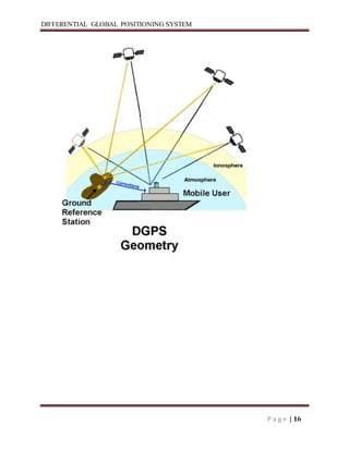
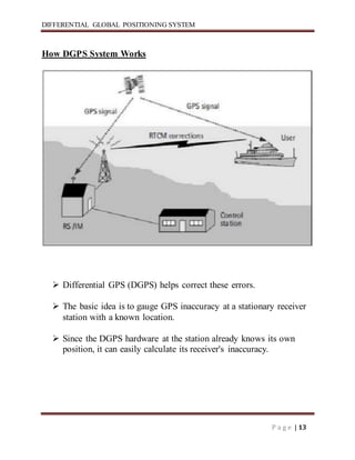
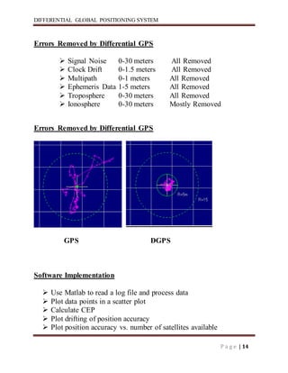
DIFFERENTIAL GLOBAL POSITIONING SYSTEM
P a g e | 1
ABSTRACT
Normal GPS (Global Positioning System) is not accurate enough
for the applications. For greater accuracy, a Differential GPS
system will be implemented. To do this, two GPS units are
required. A base station, with a known position, sends error
correction data to a mobile unit. The error correction data is sent
wirelessly through a radio link. The data can then be viewed on a
laptop computer for statistical analysis.
DIFFERENTIAL GLOBAL POSITIONING SYSTEM
P a g e | 2
INTRODUCTION
What is dgps?
 DGPS stands for Differential Global Positioning System.
 DGPS improves the GPS position and speed
measurements.
 DGPS provides perfect location within 10 cm.
 This technique was developed in the early 1980s.
DIFFERENTIAL GLOBAL POSITIONING SYSTEM
P a g e | 3
 GPS systems have created the most accurate positioning systems in human
history. The system in your car knows when you come to the corner and
which way to turn. But even with that precision, there are applications that
would benefit from even more exact positioning measurements. For
example, a trucking company might like to know on which side of the street
their vehicle is parked. That is where DGPS comes in.
 Differential Global Positioning System(DGPS) is an enhancement
to Global Positioning System that provides improved location accuracy,
from the 15-meter nominal GPS accuracy to about 10 cm in case of the best
implementations.
 DGPS uses a network of fixed, ground-based reference stations to broadcast
the difference between the positions indicated by the satellite systems and
the known fixed positions. These stations broadcastthe difference between
the measured satellite and actual (internally computed)pseudo ranges, and
receiver stations may correct their pseudo ranges by the same amount. The
digital correction signal is typically broadcastlocally over ground-based
transmitters of shorter range.
 The military requires very precise measurements across their battle
scene. The DGPS receiver system run by the Indian US and Canadian Coast
Guards that guides shipping, especially in harbor as they maneuver. But
other private users can find the increased accuracy useful as well.
DIFFERENTIAL GLOBAL POSITIONING SYSTEM
P a g e | 4
HISTORY OF GPS
 GLOBAL POSITIONING SYSTEM IS DEVELOPED AND FUNDED BY
US GOVERNMENT AND MANAGED BY DEPARTMENT OF
DEFENCE.
 1973 -DECISION TO DEVELOP A SATELLITE NAVIGATION
SYSTEM FOR MILITARY 1974 -1979 CONDUCTED SYSTEM TESTS
BY US AIR FORCEAND NAVY
 2000 –FINAL DEACTIVATION OF SA TO GIVE POSITIONAL
ACCURACY OF20m FROM 100m.
2005 –LAUNCHING OF THE IIRM GPS SATELLITE THAT SUPPORTS
THE NEW MILITARY M SIGNAL AND THE SECOND CIVIL SIGNAL
L2C.
DIFFERENTIAL GLOBAL POSITIONING SYSTEM
P a g e | 5
History of DGPS
 Differential GPS (DGPS) is a relatively Differential GPS (DGPS)is a
relatively simple technique to improve positional simple technique to
improve positional accuracy and integrity.
 This technique was accuracy and integrity. This technique was developed in
the early 1980s, and it is developed in the early 1980s, and it is widely used
in various forms.
DGPS IN DETAIL
 DGPS is a method of improving the accuracy of your receiver by adding a
local reference station to augment the information available from the
satellites. It also improves the integrity of the whole GPS system by
identifying certain errors.
 Differential GPS uses one unit at a known location and a rover. –The
stationary unit compares its calculated GPS location with the actual location
and computes the error. –The rover data is adjusted for the error.
 The stationary unit compares its calculated GPS location with the actual
location and computes the error. –The rover data is adjusted for the error.
 The rover data is adjusted for the error.
 The underlying premise of differential GPS (DGPS) is that any two receivers
that are (DGPS) is that any two receivers that are relatively close together
will experience similar relatively close together will experience similar
atmospheric errors. atmospheric errors.
DIFFERENTIAL GLOBAL POSITIONING SYSTEM
P a g e | 6
 DGPS requires that a GPS receiver be set up DGPS requires that a GPS
receiver be set up on a precisely known location. This GPS on a precisely
known location. This GPS receiver is the base or reference station. Receiver
is the baseor reference station.
 The base station receiver calculates its position the base station receiver
calculates its position based on satellite signals and compares this based on
satellite signals and compares this location to the known location.
 The difference is applied to the GPS data recorded The difference is applied
to the GPS data recorded by the second GPS receiver, which is known as by
the second GPS receiver, which is known as the roving receiver.
 The corrected information can the roving receiver.
 The corrected information can be applied to data from the roving receiver in
real be applied to data from the roving receiver in real time in the field using
radio signals or through time in the field using radio signals or through post
post-processing after data capture using special processingafter data capture
using special processingsoftware.
 Differential correction techniques are used to enhance the quality of location
data gathered enhance the quality of location data gathered using global
positioning system (GPS) receivers.
 Differential correction can be applied in real-time directly in the field or
when posttime directly in the field or when post-processingprocessing data
in the office.
 Although both methods are data in the office. Although both methods are
based on the same underlying principles, each based on the same underlying
principles, each accesses different data sources and achieves accesses
different data sources and achieves different levels of accuracy. Combining
both different levels of accuracy. Combining both methods provides
flexibility during data methods provides flexibility during data collection
and improves data integrity.
DIFFERENTIAL GLOBAL POSITIONING SYSTEM
P a g e | 7
There is two types of dgps system.
(1)Real-Time DGPS
(2)Satellite Differential Services
(1)Real-Time DGPS
 Real-time DGPS occurs when the base time DGPS occurs when the base
station calculates and broadcasts station calculates and broadcasts
corrections for each satellite as it receives corrections for each satellite as it
receives the data. The correction is received by the the data. The correction
is received by the roving receiver via a radio signal.
 As a result, the position displayed and As a result, the position displayed and
logged to the data file of the roving GPS logged to the data file of the roving
GPS receiver is a differentially corrected receiver is a differentially
corrected position.
(2) Satellite Differential Services
 Another method for obtaining real-time time differential correction data in
the field is by differential correction data in the field is by using
geostationary satellites.
 This system using geostationary satellites.
 This system obtains corrections from more than one obtains corrections from
more than one reference station, sends the information to reference station,
sends the information to a geostationary satellite for verification. a
geostationary satellite for verification.
 The verified information is sent to The verified information is sent to the
roving GPS receiver to ensure it obtains roving GPS receiver to ensure it
obtains GPS positions in real time.
DIFFERENTIAL GLOBAL POSITIONING SYSTEM
P a g e | 8
Error possibilities in GPS
 The receiver is not synchronized with the receiver is not
Synchronized with the atomic clock in the satellite.
 The estimate of the position of the satellite.
 Speed of light is only constant in vacuum
 ”Multi path errors” : Ghost signals from ”Multi path errors” :
Ghost signals from reflected radio waves
 ”Selective availability (SA)” :Added noise from ”Selective
availability (SA)” :Added noise from department of defense
 Not free sight to many enough satellites
 Noise in the receiver
DIFFERENTIAL GLOBAL POSITIONING SYSTEM
P a g e | 9
SOURCES OF ERROR IN GPS
Error Value
Ionosphere 4.0 meters
Clock 2.1 meters
Ephemeris 2.1 meters
Troposphere 0.7 meters
Receiver 0.5 meters
Multipath 1.0 meter
Total 10.4 meters
DIFFERENTIAL GLOBAL POSITIONING SYSTEM
P a g e | 10
GPS Errors
 Noise Error
 Biases Error
 Blunder Error
 Clock
Noise Error
 Noise errors are the combined effect of codenoise (around 1 meter) and
noise within the noise (around 1 meter) and noise within the receiver
(around 1 meter).
BIAS ERROR
Selective availability is turned off.
 Ephemeris data errors: 1 meter
 Satellite orbits are constantly changing. Any error Satellite orbits
are constantly changing. Any error in satellite position will result
in an error for the in satellite position will result in an error for the
receiver position
 SV clock errors uncorrected by Control SV clock errors
uncorrected by Control Segment can result in one meter error.
DIFFERENTIAL GLOBAL POSITIONING SYSTEM
P a g e | 11
Tropospheric Troposphericdelays: 1 meter.
 The troposphere is the lower part The troposphere is the lower part
(ground level to from 8 to 13 km) of the (ground level to from 8 to
13 km) of the atmosphere that experiences the atmosphere that
experiences the changes in temperature, pressure, and changes in
temperature, pressure, and humidity associated with weather
humidity associated with weather changes.
 Complex models of Complex models oftropospheric
troposphericdelay delay require estimates or measurements of
require estimates or measurements of these parameters.
 Unmodeledionosphere delays: 10 meters.
 Multipath: 0.5 meters.
Blunder
 Blunders can result in errors of hundred of Blunders can result in
errors of hundred of kilometers.
 Control segment mistakes due to computer or human
Control segment mistakes due to computer or human
error can cause errors from one meter to hundreds of
kilometers.
 Receiver errors from software or hardware Receiver errors from
software or hardware failures can cause blunder errors of any size.
failures can cause blunder errors of any size.
DIFFERENTIAL GLOBAL POSITIONING SYSTEM
P a g e | 12
Equipment Used
(1)Two NovAtel® RT-20 Receivers
(2)Operate at 1575.42 MHz
(3)12 Channel Receivers
(4)Two FreeWave® Radios
(5)Operate at 928 MHz
(6)20 mile line of sight range
(7)Laptop,Computer
COMPONENTS OF DGPS
 MASTER RECEIVER AND ROVERS
 MASTER RECEIVER IS KEPT AT MASTER RECEIVER IS KEPT AT
KNOWN POINT.
 RELATIVE POSITIONOF ROVERS ARE FIXED WITH RESPECT TO
THE FIXED WITH RESPECT TO THE MASTER RECEIVER.
DIFFERENTIAL GLOBAL POSITIONING SYSTEM
P a g e | 13
How DGPS System Works
 Differential GPS (DGPS) helps correct these errors.
 The basic idea is to gauge GPS inaccuracy at a stationary receiver
station with a known location.
 Since the DGPS hardware at the station already knows its own
position, it can easily calculate its receiver's inaccuracy.
DIFFERENTIAL GLOBAL POSITIONING SYSTEM
P a g e | 14
Errors Removed by Differential GPS
 Signal Noise 0-30 meters All Removed
 Clock Drift 0-1.5 meters All Removed
 Multipath 0-1 meters All Removed
 Ephemeris Data 1-5 meters All Removed
 Troposphere 0-30 meters All Removed
 Ionosphere 0-30 meters Mostly Removed
Errors Removed by Differential GPS
GPS DGPS
Software Implementation
 Use Matlab to read a log file and process data
 Plot data points in a scatter plot
 Calculate CEP
 Plot drifting of position accuracy
 Plot position accuracy vs. number of satellites available
DIFFERENTIAL GLOBAL POSITIONING SYSTEM
P a g e | 15
Opening and reading log file
 R = input('What type of log file is it? 1=POSA 2=P20A 3=P20A
and DOPA ')
 file = INPUTDLG('Enter the File name','Enter GPS log file to
open')
 [time lat long height] = textread(file, ' %*s %f %*[^n]',
'delimiter',',')
Coordinate conversion
 Local (North, East, Down)
 Uses a reference point to find the change in direction
 Converts to meters
Calculating a Position
 Measure distance to satellites.
 Obtain satellite positions.
 Perform triangulation calculations. (Trilateration)
 Adjust local clock bias.
DIFFERENTIAL GLOBAL POSITIONING SYSTEM
P a g e | 16
DIFFERENTIAL GLOBAL POSITIONING SYSTEM
P a g e | 17
DGPS Stations in India
Sr
No.
Location Frequency(KHz)
(285-325)
1 Hazira 312.0
2 Suratkal 320.0
3 Porbandar 293.0
4 Ratnagiri 308.0
5 Okha 296.0
6 Gopnath 299.0
7 Uttan 306.0
8 Aguada 288.0
9 Azhikode 318.0
10 Minicoy Island 306.0
11 Pondicherry 312.0
12 Nagapattnam 323.0
13 Pandian Tivu 309.0
DIFFERENTIAL GLOBAL POSITIONING SYSTEM
P a g e | 18
14 Pulicat 319.0
15 Dolphins 295.0
16 Krishnapatnam 297.0
17 Antervedi 320.0
18 Sagar Island 218.0
19 Paradeep 290.0
20 Keating Point 317.0
21 Campbell bay 303.0
22 East Island 313.0
23 Rameshwaram 298.0
DIFFERENTIAL GLOBAL POSITIONING SYSTEM
P a g e | 19
Advantages
 GPS is quite accurate; however, using DGPS pushes its accuracy even
further.
 GPS/DGPS makes A/L guidance every precise as opposeto ILS and
MLS.
 DGPS helps to know perfect location on the earth and sea also.
 Provide accurate data within a minute.
LIMITATIONS
 The coverage area to take advantage of DGPS is limited.
 To ensure greater coverage area more DGPS stations need to be added.
 The position accuracy degrades as the separation between DGPS and aircraft
GPS-Rxincreases.
DIFFERENTIAL GLOBAL POSITIONING SYSTEM
P a g e | 20
Applications
 Air Navigation
 By using it a pilot can receive constant information about where the
plane is in 3 dimensions.
 Weather forecasting
 Where atmospheric information can be gained from its effects on the
satellite signals.
 Train Control
 For such things as avoiding collisions and routing.
 Marine, Ship Navigation
 By using it a ship can receive constant information about
current location and parking location on port.
DIFFERENTIAL GLOBAL POSITIONING SYSTEM
P a g e | 21
Conclusion
 The achievable accuracy of horizontal position using the DGPS
method during typical SA is at the level of 3 meters in terms of rms.
The final DGPS error is caused by GPS receiver noise and systematic
errors. The systematic errors are orbit, tropospheric, ionospheric and
residual satellite clock SA dithering errors.
 The influence of systematic errors on a determined position is
dependent on station separation and the age of data of differential
corrections.
 The DGPS accuracy deteriorates with distance due to spatial decor
relation of the certain DGPS errors. However, the target three meter
DGPS accuracy can be maintained for distances up to 300 kilometers,
provided differential tropospheric and ionospheric corrections are
used. These corrections are not presently applied to internal solutions
of the investigated GPS receivers.
 The new generation of Leica DGPS Beacon Systems now being used
by DGLL meets rigorous standards of reliability, maintainability, ease
of installation, ease of use, accuracy, and integrity.
DIFFERENTIAL GLOBAL POSITIONING SYSTEM
P a g e | 22
References
www.en.wikipedia.org
www.dgll.nic.in

Dgps seminar

  • 1.
    DIFFERENTIAL GLOBAL POSITIONINGSYSTEM P a g e | 1 ABSTRACT Normal GPS (Global Positioning System) is not accurate enough for the applications. For greater accuracy, a Differential GPS system will be implemented. To do this, two GPS units are required. A base station, with a known position, sends error correction data to a mobile unit. The error correction data is sent wirelessly through a radio link. The data can then be viewed on a laptop computer for statistical analysis.
  • 2.
    DIFFERENTIAL GLOBAL POSITIONINGSYSTEM P a g e | 2 INTRODUCTION What is dgps?  DGPS stands for Differential Global Positioning System.  DGPS improves the GPS position and speed measurements.  DGPS provides perfect location within 10 cm.  This technique was developed in the early 1980s.
  • 3.
    DIFFERENTIAL GLOBAL POSITIONINGSYSTEM P a g e | 3  GPS systems have created the most accurate positioning systems in human history. The system in your car knows when you come to the corner and which way to turn. But even with that precision, there are applications that would benefit from even more exact positioning measurements. For example, a trucking company might like to know on which side of the street their vehicle is parked. That is where DGPS comes in.  Differential Global Positioning System(DGPS) is an enhancement to Global Positioning System that provides improved location accuracy, from the 15-meter nominal GPS accuracy to about 10 cm in case of the best implementations.  DGPS uses a network of fixed, ground-based reference stations to broadcast the difference between the positions indicated by the satellite systems and the known fixed positions. These stations broadcastthe difference between the measured satellite and actual (internally computed)pseudo ranges, and receiver stations may correct their pseudo ranges by the same amount. The digital correction signal is typically broadcastlocally over ground-based transmitters of shorter range.  The military requires very precise measurements across their battle scene. The DGPS receiver system run by the Indian US and Canadian Coast Guards that guides shipping, especially in harbor as they maneuver. But other private users can find the increased accuracy useful as well.
  • 4.
    DIFFERENTIAL GLOBAL POSITIONINGSYSTEM P a g e | 4 HISTORY OF GPS  GLOBAL POSITIONING SYSTEM IS DEVELOPED AND FUNDED BY US GOVERNMENT AND MANAGED BY DEPARTMENT OF DEFENCE.  1973 -DECISION TO DEVELOP A SATELLITE NAVIGATION SYSTEM FOR MILITARY 1974 -1979 CONDUCTED SYSTEM TESTS BY US AIR FORCEAND NAVY  2000 –FINAL DEACTIVATION OF SA TO GIVE POSITIONAL ACCURACY OF20m FROM 100m. 2005 –LAUNCHING OF THE IIRM GPS SATELLITE THAT SUPPORTS THE NEW MILITARY M SIGNAL AND THE SECOND CIVIL SIGNAL L2C.
  • 5.
    DIFFERENTIAL GLOBAL POSITIONINGSYSTEM P a g e | 5 History of DGPS  Differential GPS (DGPS) is a relatively Differential GPS (DGPS)is a relatively simple technique to improve positional simple technique to improve positional accuracy and integrity.  This technique was accuracy and integrity. This technique was developed in the early 1980s, and it is developed in the early 1980s, and it is widely used in various forms. DGPS IN DETAIL  DGPS is a method of improving the accuracy of your receiver by adding a local reference station to augment the information available from the satellites. It also improves the integrity of the whole GPS system by identifying certain errors.  Differential GPS uses one unit at a known location and a rover. –The stationary unit compares its calculated GPS location with the actual location and computes the error. –The rover data is adjusted for the error.  The stationary unit compares its calculated GPS location with the actual location and computes the error. –The rover data is adjusted for the error.  The rover data is adjusted for the error.  The underlying premise of differential GPS (DGPS) is that any two receivers that are (DGPS) is that any two receivers that are relatively close together will experience similar relatively close together will experience similar atmospheric errors. atmospheric errors.
  • 6.
    DIFFERENTIAL GLOBAL POSITIONINGSYSTEM P a g e | 6  DGPS requires that a GPS receiver be set up DGPS requires that a GPS receiver be set up on a precisely known location. This GPS on a precisely known location. This GPS receiver is the base or reference station. Receiver is the baseor reference station.  The base station receiver calculates its position the base station receiver calculates its position based on satellite signals and compares this based on satellite signals and compares this location to the known location.  The difference is applied to the GPS data recorded The difference is applied to the GPS data recorded by the second GPS receiver, which is known as by the second GPS receiver, which is known as the roving receiver.  The corrected information can the roving receiver.  The corrected information can be applied to data from the roving receiver in real be applied to data from the roving receiver in real time in the field using radio signals or through time in the field using radio signals or through post post-processing after data capture using special processingafter data capture using special processingsoftware.  Differential correction techniques are used to enhance the quality of location data gathered enhance the quality of location data gathered using global positioning system (GPS) receivers.  Differential correction can be applied in real-time directly in the field or when posttime directly in the field or when post-processingprocessing data in the office.  Although both methods are data in the office. Although both methods are based on the same underlying principles, each based on the same underlying principles, each accesses different data sources and achieves accesses different data sources and achieves different levels of accuracy. Combining both different levels of accuracy. Combining both methods provides flexibility during data methods provides flexibility during data collection and improves data integrity.
  • 7.
    DIFFERENTIAL GLOBAL POSITIONINGSYSTEM P a g e | 7 There is two types of dgps system. (1)Real-Time DGPS (2)Satellite Differential Services (1)Real-Time DGPS  Real-time DGPS occurs when the base time DGPS occurs when the base station calculates and broadcasts station calculates and broadcasts corrections for each satellite as it receives corrections for each satellite as it receives the data. The correction is received by the the data. The correction is received by the roving receiver via a radio signal.  As a result, the position displayed and As a result, the position displayed and logged to the data file of the roving GPS logged to the data file of the roving GPS receiver is a differentially corrected receiver is a differentially corrected position. (2) Satellite Differential Services  Another method for obtaining real-time time differential correction data in the field is by differential correction data in the field is by using geostationary satellites.  This system using geostationary satellites.  This system obtains corrections from more than one obtains corrections from more than one reference station, sends the information to reference station, sends the information to a geostationary satellite for verification. a geostationary satellite for verification.  The verified information is sent to The verified information is sent to the roving GPS receiver to ensure it obtains roving GPS receiver to ensure it obtains GPS positions in real time.
  • 8.
    DIFFERENTIAL GLOBAL POSITIONINGSYSTEM P a g e | 8 Error possibilities in GPS  The receiver is not synchronized with the receiver is not Synchronized with the atomic clock in the satellite.  The estimate of the position of the satellite.  Speed of light is only constant in vacuum  ”Multi path errors” : Ghost signals from ”Multi path errors” : Ghost signals from reflected radio waves  ”Selective availability (SA)” :Added noise from ”Selective availability (SA)” :Added noise from department of defense  Not free sight to many enough satellites  Noise in the receiver
  • 9.
    DIFFERENTIAL GLOBAL POSITIONINGSYSTEM P a g e | 9 SOURCES OF ERROR IN GPS Error Value Ionosphere 4.0 meters Clock 2.1 meters Ephemeris 2.1 meters Troposphere 0.7 meters Receiver 0.5 meters Multipath 1.0 meter Total 10.4 meters
  • 10.
    DIFFERENTIAL GLOBAL POSITIONINGSYSTEM P a g e | 10 GPS Errors  Noise Error  Biases Error  Blunder Error  Clock Noise Error  Noise errors are the combined effect of codenoise (around 1 meter) and noise within the noise (around 1 meter) and noise within the receiver (around 1 meter). BIAS ERROR Selective availability is turned off.  Ephemeris data errors: 1 meter  Satellite orbits are constantly changing. Any error Satellite orbits are constantly changing. Any error in satellite position will result in an error for the in satellite position will result in an error for the receiver position  SV clock errors uncorrected by Control SV clock errors uncorrected by Control Segment can result in one meter error.
  • 11.
    DIFFERENTIAL GLOBAL POSITIONINGSYSTEM P a g e | 11 Tropospheric Troposphericdelays: 1 meter.  The troposphere is the lower part The troposphere is the lower part (ground level to from 8 to 13 km) of the (ground level to from 8 to 13 km) of the atmosphere that experiences the atmosphere that experiences the changes in temperature, pressure, and changes in temperature, pressure, and humidity associated with weather humidity associated with weather changes.  Complex models of Complex models oftropospheric troposphericdelay delay require estimates or measurements of require estimates or measurements of these parameters.  Unmodeledionosphere delays: 10 meters.  Multipath: 0.5 meters. Blunder  Blunders can result in errors of hundred of Blunders can result in errors of hundred of kilometers.  Control segment mistakes due to computer or human Control segment mistakes due to computer or human error can cause errors from one meter to hundreds of error can cause errors from one meter to hundreds of kilometers.  Receiver errors from software or hardware Receiver errors from software or hardware failures can cause blunder errors of any size. failures can cause blunder errors of any size.
  • 12.
    DIFFERENTIAL GLOBAL POSITIONINGSYSTEM P a g e | 12 Equipment Used (1)Two NovAtel® RT-20 Receivers (2)Operate at 1575.42 MHz (3)12 Channel Receivers (4)Two FreeWave® Radios (5)Operate at 928 MHz (6)20 mile line of sight range (7)Laptop,Computer COMPONENTS OF DGPS  MASTER RECEIVER AND ROVERS  MASTER RECEIVER IS KEPT AT MASTER RECEIVER IS KEPT AT KNOWN POINT.  RELATIVE POSITIONOF ROVERS ARE FIXED WITH RESPECT TO THE FIXED WITH RESPECT TO THE MASTER RECEIVER.
  • 13.
    DIFFERENTIAL GLOBAL POSITIONINGSYSTEM P a g e | 13 How DGPS System Works  Differential GPS (DGPS) helps correct these errors.  The basic idea is to gauge GPS inaccuracy at a stationary receiver station with a known location.  Since the DGPS hardware at the station already knows its own position, it can easily calculate its receiver's inaccuracy.
  • 14.
    DIFFERENTIAL GLOBAL POSITIONINGSYSTEM P a g e | 14 Errors Removed by Differential GPS  Signal Noise 0-30 meters All Removed  Clock Drift 0-1.5 meters All Removed  Multipath 0-1 meters All Removed  Ephemeris Data 1-5 meters All Removed  Troposphere 0-30 meters All Removed  Ionosphere 0-30 meters Mostly Removed Errors Removed by Differential GPS GPS DGPS Software Implementation  Use Matlab to read a log file and process data  Plot data points in a scatter plot  Calculate CEP  Plot drifting of position accuracy  Plot position accuracy vs. number of satellites available
  • 15.
    DIFFERENTIAL GLOBAL POSITIONINGSYSTEM P a g e | 15 Opening and reading log file  R = input('What type of log file is it? 1=POSA 2=P20A 3=P20A and DOPA ')  file = INPUTDLG('Enter the File name','Enter GPS log file to open')  [time lat long height] = textread(file, ' %*s %f %*[^n]', 'delimiter',',') Coordinate conversion  Local (North, East, Down)  Uses a reference point to find the change in direction  Converts to meters Calculating a Position  Measure distance to satellites.  Obtain satellite positions.  Perform triangulation calculations. (Trilateration)  Adjust local clock bias.
  • 16.
  • 17.
    DIFFERENTIAL GLOBAL POSITIONINGSYSTEM P a g e | 17 DGPS Stations in India Sr No. Location Frequency(KHz) (285-325) 1 Hazira 312.0 2 Suratkal 320.0 3 Porbandar 293.0 4 Ratnagiri 308.0 5 Okha 296.0 6 Gopnath 299.0 7 Uttan 306.0 8 Aguada 288.0 9 Azhikode 318.0 10 Minicoy Island 306.0 11 Pondicherry 312.0 12 Nagapattnam 323.0 13 Pandian Tivu 309.0
  • 18.
    DIFFERENTIAL GLOBAL POSITIONINGSYSTEM P a g e | 18 14 Pulicat 319.0 15 Dolphins 295.0 16 Krishnapatnam 297.0 17 Antervedi 320.0 18 Sagar Island 218.0 19 Paradeep 290.0 20 Keating Point 317.0 21 Campbell bay 303.0 22 East Island 313.0 23 Rameshwaram 298.0
  • 19.
    DIFFERENTIAL GLOBAL POSITIONINGSYSTEM P a g e | 19 Advantages  GPS is quite accurate; however, using DGPS pushes its accuracy even further.  GPS/DGPS makes A/L guidance every precise as opposeto ILS and MLS.  DGPS helps to know perfect location on the earth and sea also.  Provide accurate data within a minute. LIMITATIONS  The coverage area to take advantage of DGPS is limited.  To ensure greater coverage area more DGPS stations need to be added.  The position accuracy degrades as the separation between DGPS and aircraft GPS-Rxincreases.
  • 20.
    DIFFERENTIAL GLOBAL POSITIONINGSYSTEM P a g e | 20 Applications  Air Navigation  By using it a pilot can receive constant information about where the plane is in 3 dimensions.  Weather forecasting  Where atmospheric information can be gained from its effects on the satellite signals.  Train Control  For such things as avoiding collisions and routing.  Marine, Ship Navigation  By using it a ship can receive constant information about current location and parking location on port.
  • 21.
    DIFFERENTIAL GLOBAL POSITIONINGSYSTEM P a g e | 21 Conclusion  The achievable accuracy of horizontal position using the DGPS method during typical SA is at the level of 3 meters in terms of rms. The final DGPS error is caused by GPS receiver noise and systematic errors. The systematic errors are orbit, tropospheric, ionospheric and residual satellite clock SA dithering errors.  The influence of systematic errors on a determined position is dependent on station separation and the age of data of differential corrections.  The DGPS accuracy deteriorates with distance due to spatial decor relation of the certain DGPS errors. However, the target three meter DGPS accuracy can be maintained for distances up to 300 kilometers, provided differential tropospheric and ionospheric corrections are used. These corrections are not presently applied to internal solutions of the investigated GPS receivers.  The new generation of Leica DGPS Beacon Systems now being used by DGLL meets rigorous standards of reliability, maintainability, ease of installation, ease of use, accuracy, and integrity.
  • 22.
    DIFFERENTIAL GLOBAL POSITIONINGSYSTEM P a g e | 22 References www.en.wikipedia.org www.dgll.nic.in