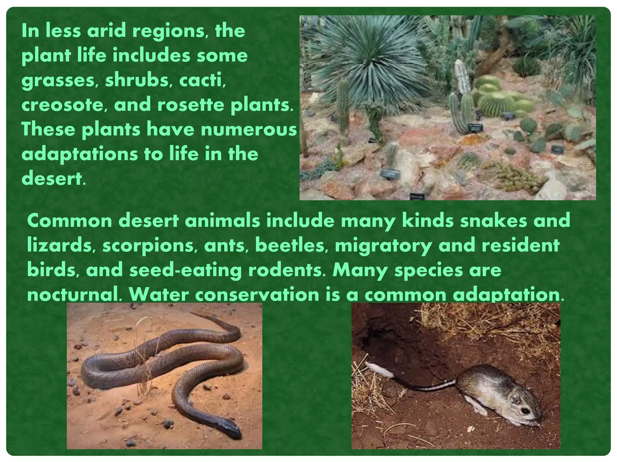
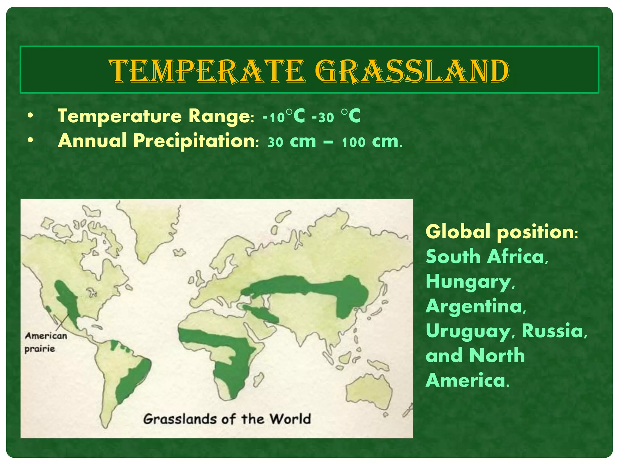
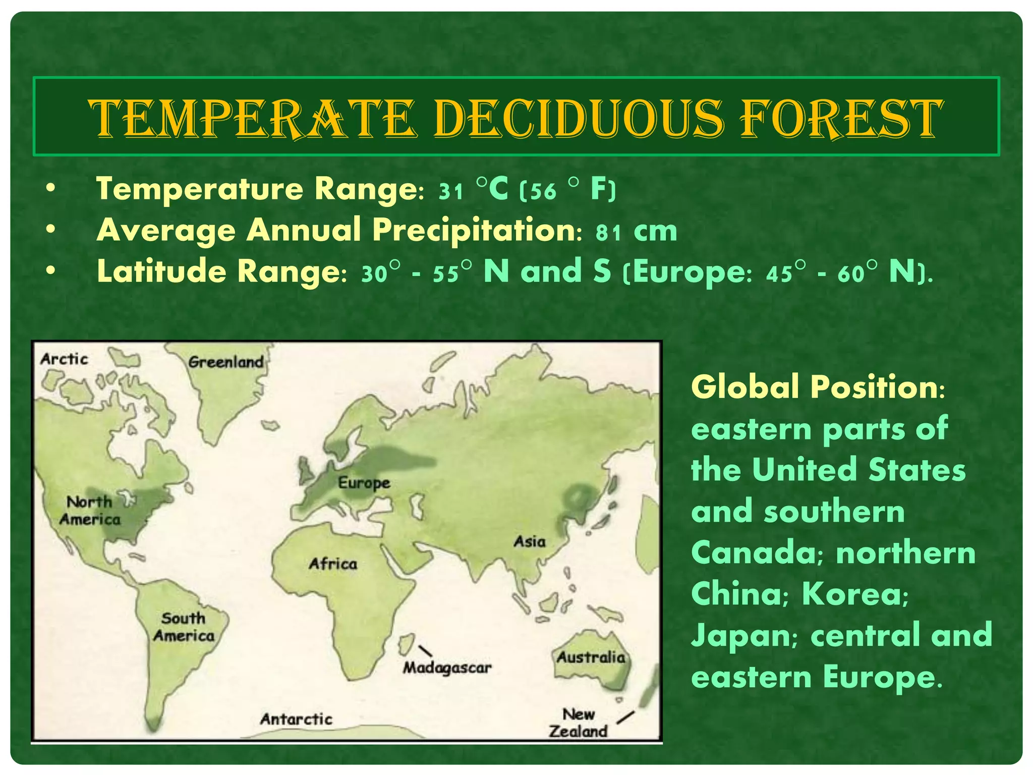
BIOGEOGRAPHY
BY
DIVYASHREE.B.R
BIOGEOGRAPHY
Biogeography is a branch of geography that studies
the past and present distribution of the world's many
species.
It is usually considered to be a part of physical
geography as it often relates to the examination of the
physical environment and how it affects species and
shaped their distribution across space.
As such it studies the world's biomes and taxonomy -
the naming of species. In addition, biogeography has
strong ties to biology, ecology, evolution studies,
climatology, and soil science.
• The study of biogeography gained
popularity with the work of Alfred
Russel Wallace in late 19th Century.
Wallace, originally from England, was
a naturalist, explorer, geographer,
anthropologist, and biologist.
• He first extensively studied the
Amazon River and then the Malay
Archipelago and gave the concept of
“Wallace line”.
• Because of his extensive early
research, Wallace is often called the
"Father of Biogeography."
HISTORY OF BIOGEOGRAPHY
Alfred Russel Wallace
TYPES OF BIOGEOGRAPHY
• Historical Biogeography – Reconstruct the
origins, dispersal, and extinctions of taxa and
biotas.
• Ecological Biogeography – Accounts for the
present distributions in terms of interactions
between organisms and their physical and
biotic environments.
• Conservation Biogeography - Work on the
protection and restoration of natural
environments.
HISTORICAL BIOGEOGRAPHY
• Historical biogeography includes data from subjects as
geology, geography, and biology to meet its aim.
• The branch of historical biogeography is called
paleobiogeography because it often includes
paleogeographic ideas.
• Paleobiogeography also takes varying climate as a result
of the physical land being in different places into account
for the presence of different plants and animals.
The five basic historical biogeographic methods are:
1. Dispersalism
2. Phylogenetic Biogeography
3. Panbiogeography
4. Cladistic Biogeography
5. Parsimony Analysis of Endemity.
1. Dispersalism derives from the traditional concepts of
center of origin and dispersal.
2. Phylogenetic biogeography applies the rules of
progression and deviation to elucidate the history of the
geographical distribution of a group.
3. Panbiogeography consists of plotting distributions of
different taxa on maps, connecting their distribution areas
together with lines called individual tracks, and looking for
coincidence among individual tracks to determine
generalized tracks.
4. Cladistic biogeography assumes a correspondence
between taxonomic relationships and area
relationships, where comparisons between area
cladograms derived from different taxa allow one to
obtain general area cladograms. The most important
cladistic biogeographic procedures are: component
analysis, Brook’s parsimony analysis, three-area
statements, and reconciled trees.
5. Parsimony analysis of endemicity (PAE) classifies
areas by their shared taxa, analogous to characters,
according to the most parsimonious solution. It has the
capability of resolving different problems, such as the
recognition of spatial homology (panbiogeography), the
identification of areas of endemism (PAE), and the
formulation of hypotheses about area (cladistic
relationships biogeography).
ECOLOGICAL BIOGEOGRAPHY
The most common fields of research within
ecological biogeography are :
i. climatic equability looks at the variation between
daily and annual temperatures.
i. primary productivity looks at the evapotranspiration
rates of plants.
ii. habitat heterogeneity leads to the presence of more
biodiversity.
Climate Change and its Effect on Polar Bears
I think the place that best represents the rapid climate
changes on our planet is the Arctic ice shelf. The ecosystem
in this harsh environment is very fragile, so even the
slightest alteration will greatly affect it. One of the
animals that will be greatly affected by climate change in
the Arctic is the polar bear.
EVENTS FOR CURRENT BIOGEOGRAPHY
Polar bears live
exclusively in the
Arctic, so if they
cannot adapt to their
changing
environment, they
will be lost forever.
BIOMES
• A BIOME is the largest geographic biotic unit, a
major community of plants and animals with
similar life forms and environmental
conditions.
• There are terrestrial biomes , which are
located on land, and aquatic biomes , which
are located in oceans, lakes, rivers, or other
bodies of water.
TERRESTRIAL BIOMES
Types Of Terrestrial Biomes:
1. Tropical Forest
2. Savanna
3. Desert
4. Chaparral
5. Temperate Grassland
6. Temperate Deciduous
7. Coniferous Forest (Taiga)
8. Tundra
TROPICAL FOREST
Global Position:
Amazon Basin;
Congo Basin of
equatorial Africa;
East Indies, from
Sumatra to New
Guinea.
• Temperature Range: 23 °C
• Average Annual Precipitation: 60 -160 in
• Latitude Range: 23.5°N.
The vegetation in
tropical rain forests is
divided into five
general layers:
These include monkeys,
sloths, parrots, toucans,
bats, tapirs, frogs, and
a wide variety of
insects.
SAVANNA
• Temperature Range: 16 °C
• Annual Precipitation: 0.25 cm.
• Latitude Range: 15 ° to 25 ° N and S
Global Range:
India, Indochina,
West Africa ,
southern Africa,
South America
and
the north coast
of Australia
These biomes are often found on either side of rainforests.
The soils of the savanna are usually low in nutrients. The
soils are porous, having only a thin layer of nutrient rich
matter called humus.
Plant life is composed of low
growing grasses with
scattered deciduous trees
and thorny shrubs, Acacias,
Eucalypts and Baobab.
There are frequent fires in the savanna. The dominant
vegetation is fire adapted, but many seedlings are killed
before they become established, by fire or by grazing
animals. The fires also remove dead plant material
and recycle nutrients that support new growth.
Animals found here include large herbivores such as giraffes,
zebras, antelopes, buffalo, kangaroos, wildebeests, and
ostriches.
There are also many burrowing animals found here,
including mice, gophers, snakes, as well as ants and
termites.
During the dry season, many small animals are dormant, and
larger mammals often migrate to other areas.
DESERT
• Temperature Range: 16° C
• Annual Precipitation: less than 3o cm.
• Range: 15° - 35° N and S.
Global Range:
southwestern
United States
and northern
Mexico Argentina;
north Africa;
south Africa;
central part of
Australia.
Deserts are the driest of all biomes.
Most deserts are very hot, but cold deserts also exist. The
hot deserts generally experience hot days and cold
nights.
Hot deserts can be found
in the southwest of the
United States, along the
coast of South America, in
northern Africa, and in the
Middle East.
There are cold deserts to
the west of the Rocky
Mountains, in eastern
Argentina and central Asia.
Common desert animals include many kinds snakes and
lizards, scorpions, ants, beetles, migratory and resident
birds, and seed-eating rodents. Many species are
nocturnal. Water conservation is a common adaptation.
In less arid regions, the
plant life includes some
grasses, shrubs, cacti,
creosote, and rosette plants.
These plants have numerous
adaptations to life in the
desert.
CHAPARREL
• Temperature Range: 7 °C (12 °F)
• Annual Precipitation: 42 cm (17 in).
• Latitude Range: 30° - 50° N and S
Global Position:
central and
southern
California; coastal
bordering the
Mediterranean
Sea; Cape Town
region of South
Africa.
The plants found in these
region are dense, spiny
shrubs with tough
evergreen leaves. These
Plants have adaptations to
fire etc.
Animals found here
include deer, and fruit
eating birds, which are
browsers. There are
also ants and rodents,
which eat seeds, as
well as lizards and
snakes.
TEMPERATE GRASSLAND
• Temperature Range: -10°C -30 °C
• Annual Precipitation: 30 cm – 100 cm.
Global position:
South Africa,
Hungary,
Argentina,
Uruguay, Russia,
and North
America.
The soil of grassland is the deepest and most fertile in
the world.
The dominant plants are
grasses and forbs. Some of
the main adaptations of
plants are for droughts and
fire.
Large vertebrate grazers
are the most conspicuous,
such as bison, antelopes
and wild horses.
TEMPERATE DECIDUOUS FOREST
• Temperature Range: 31 °C (56 ° F)
• Average Annual Precipitation: 81 cm
• Latitude Range: 30° - 55° N and S (Europe: 45° - 60° N).
Global Position:
eastern parts of
the United States
and southern
Canada; northern
China; Korea;
Japan; central and
eastern Europe.
The soils are fertile, due to plenty of leaf litter.
There is extensive plant
diversity in this biome,
dominated by broadleaf
deciduous hardwood trees
such as oak, hickory, maple,
ash, beech and more.
The forests consist of 3-5
layers.
Animals found here are bears,
deer, bobcats, raccoons,
squirrels, as well as many
birds and invertebrates.
CONIFEROUS FOREST(TAIGA)
• Temperature Range: 41 °C, lows; -25 °C, highs; 16 °C
• Average Annual Precipitation: 31 cm (12 in).
• Latitude Range: 50° - 70° N and S.
Global Position:
central and western
Alaska; Canada, from
the Yukon Territory
to Labrador; Eurasia,
from northern Europe
across all of Siberia
to the Pacific Ocean.
Taiga, also known as coniferous or boreal forest,. It is the
largest terrestrial biome on earth.
The soil is thin, nutrient poor, and acidic.
These include different species
of spruce, pine, or fir, and
often there is little
undergrowth present.
Larger browsing animals such
as deer, moose, elk, snowshoe
hare, and beavers. The
typical predators for this area
are grizzly bears, wolves,
lynxes and wolverines.
TUNDRA
• Temperature Range: -22 °C to 6 °C (-10 °F to 41 °F).
• Average Annual Precipitation: 20 cm (8 in).
• Latitude Range: 60° - 75° N.
Global Position:
arctic zone of
North America;
Hudson Bay
region; Greenland
coast; northern
Siberia bordering
the Arctic Ocean.
The vegetation of tundra
is mostly herbaceous,
consisting of a mixture of
lichens, mosses, grasses,
and forbs along with
dwarf shrubs and trees.
Decomposition takes place slowly, because of the low
temperatures. The ground is frozen year-round, known as
permafrost.
Largest grazing musk ox is
resident, while caribou and
rein deer are migratory.
Predators include bears,
wolves, and foxes
AQUATIC BIOMES
1. Fresh Water Biome :
 Ponds and Lakes
 Streams and Rivers
 Wetlands
2. Marine Biome:
 Oceans
 Coral Reefs
 Estuaries
Types Of Aquatic Biomes:
FRESH WATER BIOMES
• Freshwater is defined as having a low salt
concentration — usually less than 1%.
• Plants and animals in freshwater regions are
adjusted to the low salt content and would
not be able to survive in areas of high salt
concentration (i.e., ocean).
• There are different types of freshwater
regions:
 Ponds and Lakes
 Streams and Rivers
 Wetlands
Ponds and lakes
 These regions range in size from just a few square meters
to thousands of square kilometers. Scattered throughout
the earth.
 Many ponds are seasonal, lasting just a couple of months
(such as sessile pools) while lakes may exist for hundreds
of years or more.
 Ponds and lakes may have limited species diversity since
they are often isolated from one another and from other
water sources like rivers and oceans.
 Temperature varies in ponds and lakes seasonally. During
the summer, the temperature can range from 4° C near the
bottom to 22° C at the top. During the winter, the
temperature at the bottom can be 4° C while the top is 0° C
Lakes and ponds are divided into three different
“zones” which are usually determined by depth and
distance from the shoreline.
These are bodies of flowing water moving in one
direction. Streams and rivers can be found
everywhere — they get their starts at headwaters,
which may be springs, snowmelt or even lakes, and
then travel all the way to their mouths, usually
another water channel or the ocean.
The characteristics of a river or stream change during
the journey from the source to the mouth.
STREAMS AND RIVERS
 Wetlands are areas of standing water that support
aquatic plants. Marshes, swamps, and bogs are all
considered wetlands.
 Plant species adapted to the very moist and humid
conditions are called hydrophytes. These include
pond lilies, cattails, sedges, tamarack, and black
spruce.
 Wetlands have the highest species diversity of all
ecosystems. Many species of amphibians, reptiles,
birds (such as ducks and waders), and furbearers
can be found in the wetlands.
Wetlands
MARINE BIOMES
Marine regions cover about three-fourths of the
Earth's surface. Marine algae supply much of the
world's oxygen supply and take in a huge
amount of atmospheric carbon dioxide. The
evaporation of the seawater provides rainwater
for the land.
It includes:
 Oceans
 Coral Reefs
 Estuaries
The largest of all the ecosystems, oceans are very large
bodies of water that dominate the Earth's surface.
Like ponds and lakes, the ocean regions are separated into
separate zones: intertidal, pelagic, abyssal, and benthic. All
four zones have a great diversity of species.
OCEANS
Coral reefs are widely distributed in warm shallow waters.
They can be found as barriers along continents (e.g., the
Great Barrier Reef off Australia), fringing islands, and atolls.
Naturally, the dominant organisms in coral reefs are corals.
Corals are interesting since they consist of both algae and
tissues of animal polyp. Since reef waters tend to be
nutritionally poor, corals obtain nutrients through the algae
via photosynthesis and also by extending tentacles to obtain
plankton from the water. Besides corals, the fauna include
several species of microorganisms, invertebrates, fishes, sea
urchins, octopuses, and sea stars.
CORAL REEFS
Estuaries are areas where freshwater streams or rivers
merge with the ocean. This mixing of waters with such
different salt concentrations creates a very interesting and
unique ecosystem. Microflora like algae, and macroflora,
such as seaweeds, marsh grasses can be found here.
Estuaries support a diverse fauna, including a variety of
worms, oysters, crabs, and waterfowl.
ESTUARIES
THANK YOU

Biogeography

  • 1.
  • 2.
    BIOGEOGRAPHY Biogeography is abranch of geography that studies the past and present distribution of the world's many species. It is usually considered to be a part of physical geography as it often relates to the examination of the physical environment and how it affects species and shaped their distribution across space. As such it studies the world's biomes and taxonomy - the naming of species. In addition, biogeography has strong ties to biology, ecology, evolution studies, climatology, and soil science.
  • 3.
    • The studyof biogeography gained popularity with the work of Alfred Russel Wallace in late 19th Century. Wallace, originally from England, was a naturalist, explorer, geographer, anthropologist, and biologist. • He first extensively studied the Amazon River and then the Malay Archipelago and gave the concept of “Wallace line”. • Because of his extensive early research, Wallace is often called the "Father of Biogeography." HISTORY OF BIOGEOGRAPHY Alfred Russel Wallace
  • 4.
    TYPES OF BIOGEOGRAPHY •Historical Biogeography – Reconstruct the origins, dispersal, and extinctions of taxa and biotas. • Ecological Biogeography – Accounts for the present distributions in terms of interactions between organisms and their physical and biotic environments. • Conservation Biogeography - Work on the protection and restoration of natural environments.
  • 5.
    HISTORICAL BIOGEOGRAPHY • Historicalbiogeography includes data from subjects as geology, geography, and biology to meet its aim. • The branch of historical biogeography is called paleobiogeography because it often includes paleogeographic ideas. • Paleobiogeography also takes varying climate as a result of the physical land being in different places into account for the presence of different plants and animals.
  • 6.
    The five basichistorical biogeographic methods are: 1. Dispersalism 2. Phylogenetic Biogeography 3. Panbiogeography 4. Cladistic Biogeography 5. Parsimony Analysis of Endemity. 1. Dispersalism derives from the traditional concepts of center of origin and dispersal. 2. Phylogenetic biogeography applies the rules of progression and deviation to elucidate the history of the geographical distribution of a group. 3. Panbiogeography consists of plotting distributions of different taxa on maps, connecting their distribution areas together with lines called individual tracks, and looking for coincidence among individual tracks to determine generalized tracks.
  • 7.
    4. Cladistic biogeographyassumes a correspondence between taxonomic relationships and area relationships, where comparisons between area cladograms derived from different taxa allow one to obtain general area cladograms. The most important cladistic biogeographic procedures are: component analysis, Brook’s parsimony analysis, three-area statements, and reconciled trees. 5. Parsimony analysis of endemicity (PAE) classifies areas by their shared taxa, analogous to characters, according to the most parsimonious solution. It has the capability of resolving different problems, such as the recognition of spatial homology (panbiogeography), the identification of areas of endemism (PAE), and the formulation of hypotheses about area (cladistic relationships biogeography).
  • 8.
    ECOLOGICAL BIOGEOGRAPHY The mostcommon fields of research within ecological biogeography are : i. climatic equability looks at the variation between daily and annual temperatures. i. primary productivity looks at the evapotranspiration rates of plants. ii. habitat heterogeneity leads to the presence of more biodiversity.
  • 9.
    Climate Change andits Effect on Polar Bears I think the place that best represents the rapid climate changes on our planet is the Arctic ice shelf. The ecosystem in this harsh environment is very fragile, so even the slightest alteration will greatly affect it. One of the animals that will be greatly affected by climate change in the Arctic is the polar bear. EVENTS FOR CURRENT BIOGEOGRAPHY Polar bears live exclusively in the Arctic, so if they cannot adapt to their changing environment, they will be lost forever.
  • 10.
    BIOMES • A BIOMEis the largest geographic biotic unit, a major community of plants and animals with similar life forms and environmental conditions. • There are terrestrial biomes , which are located on land, and aquatic biomes , which are located in oceans, lakes, rivers, or other bodies of water.
  • 11.
    TERRESTRIAL BIOMES Types OfTerrestrial Biomes: 1. Tropical Forest 2. Savanna 3. Desert 4. Chaparral 5. Temperate Grassland 6. Temperate Deciduous 7. Coniferous Forest (Taiga) 8. Tundra
  • 12.
    TROPICAL FOREST Global Position: AmazonBasin; Congo Basin of equatorial Africa; East Indies, from Sumatra to New Guinea. • Temperature Range: 23 °C • Average Annual Precipitation: 60 -160 in • Latitude Range: 23.5°N.
  • 13.
    The vegetation in tropicalrain forests is divided into five general layers: These include monkeys, sloths, parrots, toucans, bats, tapirs, frogs, and a wide variety of insects.
  • 14.
    SAVANNA • Temperature Range:16 °C • Annual Precipitation: 0.25 cm. • Latitude Range: 15 ° to 25 ° N and S Global Range: India, Indochina, West Africa , southern Africa, South America and the north coast of Australia
  • 15.
    These biomes areoften found on either side of rainforests. The soils of the savanna are usually low in nutrients. The soils are porous, having only a thin layer of nutrient rich matter called humus. Plant life is composed of low growing grasses with scattered deciduous trees and thorny shrubs, Acacias, Eucalypts and Baobab. There are frequent fires in the savanna. The dominant vegetation is fire adapted, but many seedlings are killed before they become established, by fire or by grazing animals. The fires also remove dead plant material and recycle nutrients that support new growth.
  • 16.
    Animals found hereinclude large herbivores such as giraffes, zebras, antelopes, buffalo, kangaroos, wildebeests, and ostriches. There are also many burrowing animals found here, including mice, gophers, snakes, as well as ants and termites. During the dry season, many small animals are dormant, and larger mammals often migrate to other areas.
  • 17.
    DESERT • Temperature Range:16° C • Annual Precipitation: less than 3o cm. • Range: 15° - 35° N and S. Global Range: southwestern United States and northern Mexico Argentina; north Africa; south Africa; central part of Australia.
  • 18.
    Deserts are thedriest of all biomes. Most deserts are very hot, but cold deserts also exist. The hot deserts generally experience hot days and cold nights. Hot deserts can be found in the southwest of the United States, along the coast of South America, in northern Africa, and in the Middle East. There are cold deserts to the west of the Rocky Mountains, in eastern Argentina and central Asia.
  • 19.
    Common desert animalsinclude many kinds snakes and lizards, scorpions, ants, beetles, migratory and resident birds, and seed-eating rodents. Many species are nocturnal. Water conservation is a common adaptation. In less arid regions, the plant life includes some grasses, shrubs, cacti, creosote, and rosette plants. These plants have numerous adaptations to life in the desert.
  • 20.
    CHAPARREL • Temperature Range:7 °C (12 °F) • Annual Precipitation: 42 cm (17 in). • Latitude Range: 30° - 50° N and S Global Position: central and southern California; coastal bordering the Mediterranean Sea; Cape Town region of South Africa.
  • 21.
    The plants foundin these region are dense, spiny shrubs with tough evergreen leaves. These Plants have adaptations to fire etc. Animals found here include deer, and fruit eating birds, which are browsers. There are also ants and rodents, which eat seeds, as well as lizards and snakes.
  • 22.
    TEMPERATE GRASSLAND • TemperatureRange: -10°C -30 °C • Annual Precipitation: 30 cm – 100 cm. Global position: South Africa, Hungary, Argentina, Uruguay, Russia, and North America.
  • 23.
    The soil ofgrassland is the deepest and most fertile in the world. The dominant plants are grasses and forbs. Some of the main adaptations of plants are for droughts and fire. Large vertebrate grazers are the most conspicuous, such as bison, antelopes and wild horses.
  • 24.
    TEMPERATE DECIDUOUS FOREST •Temperature Range: 31 °C (56 ° F) • Average Annual Precipitation: 81 cm • Latitude Range: 30° - 55° N and S (Europe: 45° - 60° N). Global Position: eastern parts of the United States and southern Canada; northern China; Korea; Japan; central and eastern Europe.
  • 25.
    The soils arefertile, due to plenty of leaf litter. There is extensive plant diversity in this biome, dominated by broadleaf deciduous hardwood trees such as oak, hickory, maple, ash, beech and more. The forests consist of 3-5 layers. Animals found here are bears, deer, bobcats, raccoons, squirrels, as well as many birds and invertebrates.
  • 26.
    CONIFEROUS FOREST(TAIGA) • TemperatureRange: 41 °C, lows; -25 °C, highs; 16 °C • Average Annual Precipitation: 31 cm (12 in). • Latitude Range: 50° - 70° N and S. Global Position: central and western Alaska; Canada, from the Yukon Territory to Labrador; Eurasia, from northern Europe across all of Siberia to the Pacific Ocean.
  • 27.
    Taiga, also knownas coniferous or boreal forest,. It is the largest terrestrial biome on earth. The soil is thin, nutrient poor, and acidic. These include different species of spruce, pine, or fir, and often there is little undergrowth present. Larger browsing animals such as deer, moose, elk, snowshoe hare, and beavers. The typical predators for this area are grizzly bears, wolves, lynxes and wolverines.
  • 28.
    TUNDRA • Temperature Range:-22 °C to 6 °C (-10 °F to 41 °F). • Average Annual Precipitation: 20 cm (8 in). • Latitude Range: 60° - 75° N. Global Position: arctic zone of North America; Hudson Bay region; Greenland coast; northern Siberia bordering the Arctic Ocean.
  • 29.
    The vegetation oftundra is mostly herbaceous, consisting of a mixture of lichens, mosses, grasses, and forbs along with dwarf shrubs and trees. Decomposition takes place slowly, because of the low temperatures. The ground is frozen year-round, known as permafrost. Largest grazing musk ox is resident, while caribou and rein deer are migratory. Predators include bears, wolves, and foxes
  • 30.
    AQUATIC BIOMES 1. FreshWater Biome :  Ponds and Lakes  Streams and Rivers  Wetlands 2. Marine Biome:  Oceans  Coral Reefs  Estuaries Types Of Aquatic Biomes:
  • 31.
    FRESH WATER BIOMES •Freshwater is defined as having a low salt concentration — usually less than 1%. • Plants and animals in freshwater regions are adjusted to the low salt content and would not be able to survive in areas of high salt concentration (i.e., ocean). • There are different types of freshwater regions:  Ponds and Lakes  Streams and Rivers  Wetlands
  • 32.
    Ponds and lakes These regions range in size from just a few square meters to thousands of square kilometers. Scattered throughout the earth.  Many ponds are seasonal, lasting just a couple of months (such as sessile pools) while lakes may exist for hundreds of years or more.  Ponds and lakes may have limited species diversity since they are often isolated from one another and from other water sources like rivers and oceans.  Temperature varies in ponds and lakes seasonally. During the summer, the temperature can range from 4° C near the bottom to 22° C at the top. During the winter, the temperature at the bottom can be 4° C while the top is 0° C
  • 33.
    Lakes and pondsare divided into three different “zones” which are usually determined by depth and distance from the shoreline.
  • 34.
    These are bodiesof flowing water moving in one direction. Streams and rivers can be found everywhere — they get their starts at headwaters, which may be springs, snowmelt or even lakes, and then travel all the way to their mouths, usually another water channel or the ocean. The characteristics of a river or stream change during the journey from the source to the mouth. STREAMS AND RIVERS
  • 35.
     Wetlands areareas of standing water that support aquatic plants. Marshes, swamps, and bogs are all considered wetlands.  Plant species adapted to the very moist and humid conditions are called hydrophytes. These include pond lilies, cattails, sedges, tamarack, and black spruce.  Wetlands have the highest species diversity of all ecosystems. Many species of amphibians, reptiles, birds (such as ducks and waders), and furbearers can be found in the wetlands. Wetlands
  • 36.
    MARINE BIOMES Marine regionscover about three-fourths of the Earth's surface. Marine algae supply much of the world's oxygen supply and take in a huge amount of atmospheric carbon dioxide. The evaporation of the seawater provides rainwater for the land. It includes:  Oceans  Coral Reefs  Estuaries
  • 37.
    The largest ofall the ecosystems, oceans are very large bodies of water that dominate the Earth's surface. Like ponds and lakes, the ocean regions are separated into separate zones: intertidal, pelagic, abyssal, and benthic. All four zones have a great diversity of species. OCEANS
  • 38.
    Coral reefs arewidely distributed in warm shallow waters. They can be found as barriers along continents (e.g., the Great Barrier Reef off Australia), fringing islands, and atolls. Naturally, the dominant organisms in coral reefs are corals. Corals are interesting since they consist of both algae and tissues of animal polyp. Since reef waters tend to be nutritionally poor, corals obtain nutrients through the algae via photosynthesis and also by extending tentacles to obtain plankton from the water. Besides corals, the fauna include several species of microorganisms, invertebrates, fishes, sea urchins, octopuses, and sea stars. CORAL REEFS
  • 39.
    Estuaries are areaswhere freshwater streams or rivers merge with the ocean. This mixing of waters with such different salt concentrations creates a very interesting and unique ecosystem. Microflora like algae, and macroflora, such as seaweeds, marsh grasses can be found here. Estuaries support a diverse fauna, including a variety of worms, oysters, crabs, and waterfowl. ESTUARIES
  • 40.