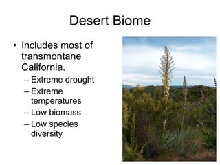
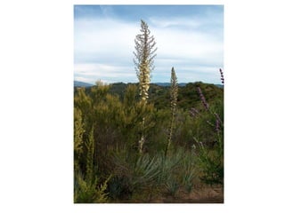
Biogeography: Distribution of Plants and Animals Chapter Five
 
California: Living Laboratory Enormous Where do we start? How do we organize our study? How do we classify the various environments? Debates revolve around the diversity, connections, and change.
California: Living Laboratory Diversity Wide range of latitude Elevation Position within subtropical and mid-latitude west coast
 
Biomes Large regional ecological units, or subdivisions of plants and animals. Biomes are the largest recognizable terrestrial ecosystems. Biomes serve as a starting point in the study of California Biogeography.
 
Ecosystems Represents a group of interacting organism and the physical environment in which they live. Provides only the most general categories and associations of California’s plants and animals.
www.goodnaturepublishing.com/Aspen.htm
 
Habitats Knowledge of habitats is critical to understanding California’s biogeography. Habitats include a combination of physical factors that represent the environmental conditions in which organisms live.
 
California Biomes Forest Biome Scrub Biome Grassland Biome Desert Biome Tundra Biome
Forest Biome The most productive biome, with the largest biomass (total weight of organisms) Occur where there is water and temperatures are not too extreme.
Forest Biome Temperate coniferous forest Needle leaved Temperate deciduous forest Broad leaved often found mixed with coniferous forests in California
 
 
Scrub Biome Includes environments from coastal scrub to chaparral and even into oak woodlands. Some consider this another biome, a dwarf schlerophyll forest (dry Mediterranean Forest). The oaks might be considered park of the savannah biome (grassland)
Grassland Biome Includes most of the cismontane inland valleys even where it is hot.
Desert Biome Includes most of transmontane California. Extreme drought Extreme temperatures Low biomass Low species diversity
Tundra Biome Only in the high elevation environments Cold temperatures Short growing seasons Limiting factors
 
 
Connections… General connections can be made when comparing California’s biomes, vegetation structure, and habitats to other regions of the world: Mediterranean Scrub: like Chile, South Africa, Australia, and the Mediterranean Coastal fog, fires, mountains Similar adjacent forests and deserts http://www.metoffice.gov.uk/education/teachers/mediterranean_climate_averages.html
 
Gocek, Turkey
Santiago, Chile
Perth, Australia
Vegetation Zones Vegetation zonation by elevation Use plant communities to paint a pictures of California’s landscape.
Living Communities Ecological succession: continual process after each event or disturbance. Primary versus secondary Climax community is in equilibrium so that it can maintain itself until the next event or disturbance.
 
Communities of Cismontane California’s Lower Elevations Coastal Sand Dune and Beach Communities Beach: the strip of coastline above the mean tide, inland to the greatest extent of storm waves. Plants and animals must adapts to waves. Coastal Sand Dunes: may extend well inland. Plants and animals must adapt to shifting sands. Coastal Strand and Littoral Strip are terms used to describe both the beach and the dunes.
Communities of Cismontane California’s Lower Elevations Habitat and Structure Marine air: Moderates temperature and brings in moisture Prone to rain and fog Salt  Wind 23% of California’s coast is beaches and dunes, but plant communities make up less than 1% of land surface.
Communities of Cismontane California’s Lower Elevations Coastal Scrub Communities AKA Coastal Sage or Soft Chaparral Similar to chaparral but smaller plants with softer leaves From Oregon to Mexico along our coasts, into the coast ranges in the south. Adapted to frequent fires.
Communities of Cismontane California’s Lower Elevations Coastal Scrub Habitat and Structure Mildest temperatures, daily and seasonally. Wide variety of species from south to north, north gets more rain. Frequently blends into dune communities, woodlands, grasslands, and chaparral, includes succulents in the south. 2.5% of California’s coast-many endangered plants and animals Pressure from coastal development.
Communities of Cismontane California’s Lower Elevations Grasslands Originally about 13% of California, especially inland valleys
Communities of Cismontane California’s Lower Elevations Grasslands Habitat and Structure Less precipitation than surrounding higher terrain. Long, hot summers: where trees and shrubs do not survive. California’s Kansas: similar to Great Plains Large grazers: tule elk and pronghorn antelope
Communities of Cismontane California’s Lower Elevations Chaparral Covers 10% of California All over the hills of Southern California Foothills of the Sierra Nevada, Southern Coast Ranges, dry spots in Northern California
Communities of Cismontane California’s Lower Elevations Chaparral Habitat and Structure Model Mediterranean drought adapted plant community. Sclerophyllous refers to the hard leaves which are often small with waxy or resinous coating and fine hair. Leaves may also curl or be oriented to decrease direct sunlight-keeps transpiration rates down during summer drought. Evergreen 800+ species  Adapted to fire (succession)  Pryophyte: only germinate and grow after fire


Communities of Cismontane California’s Lower Elevations Mixed Evergreen Forest Transition between oak and chaparral Coastal mountains of the north, southern coastal mountains 5% of California
Communities of Cismontane California’s Lower Elevations Mixed Evergreen Forest Habitat and Structure Hardwoods, especially oaks, keep leaves all year, mixed with conifers Chaparral mix
Communities of Cismontane California’s Lower Elevations Coastal Coniferous Forest Communities Oregon to Big Sur Southern extension of temperate rainforest. Contains the redwoods Habitat: located just inland from ocean to western slopes of the Klamaths and Central Coast Ranges. Average 100 inches of rain per year
Montane Coniferous Forest Communities Grow on mountain slopes From 1,000 feet in the north Between wetter forests to the west and drier communities in the east. From 5,000 feet in the south Patchy high country in the Transverse and Peninsular ranges
Montane Coniferous Forest Communities Occurs above chaparral and oak woodlands Cooler, more precipitation Higher elevation, sparser. Less precipitation.
Montane Coniferous Forest Communities Mixed/Lower Montane Coniferous Forests About 10% of California Trees about 200 feet (tallest) Mixed with oaks  Undergrowth ranges from sparse to thick Transition zone
Red Fir and Lodgepole Pine Forest/Upper Montane Forests Higher elevation Colder temperatures, heavy snow, short growing season Lodgepole dominant above 8,000 feet. Red Fir needs more moisture Lodgepoles grow at lower elevation in drier areas where Red Fir will not.
Subalpine Forests All creatures must be adapted to long, extremely cold winters-summer 7 to 9 weeks long. Above 6,500 feet in Klamaths Above 10,000 feet in the Cascades and Sierra Nevadas Upper limit is the tree line
 
Alpine Communities Isolated islands above the tree line Terrible cold and wind create very harsh conditions. Around 7,000 feet in the north, about 11,000 in the south Mt. San Antonio and San Gorgonio in the Transverse Ranges and Mt. San Jacinto in the Peninsular Ranges. Most north of southern California were covered in glaciers during the Pleistocene.
Riparian Communities Located on or adjacent to a river bank or other freshwater body. Water availability is the most important limiting factor.
Riparian Communities Lots of variety: streams in narrow strips, wide in flood channels of rivers, 10 miles wide in the Central Valley. Tall shrubs, small trees, towering giants Moist, cools, shady, protected environments. Dramatic differences in Southern California to surrounding dry land.
Transmontane Deserts California’s great physical barriers Rain shadow deserts
Transmontane Deserts Pinon Pine and Juniper Woodland Communities 4,000-8,000 feet in the desert 3% of California Below coniferous forests
Transmontane Deserts Mixed dwarf forest Winter snow 20 inches of precipitation per year Most plants related to Great Basin and Colorado Plateau species
Joshua Tree Woodlands Found at 2,000 to 5,000 feet from Southern Owens Valley through the Mojave Desert into Nevada and Arizona. Tolerate frost and occasional winter snow. Do not grow in the hot valleys of the desert.
Joshua Tree Woodlands Species from many other communities grow with them. Merge into juniper woodlands at higher elevations, creosote lower, sagebrush north. Carpet of wildflowers and grasses underneath in wetter years-lasts only a few weeks, dries and goes to seed.
 
 
Desert Scrub Communities Vast open expanses of desert scrub covers about 30% of California. Lack of water-limiting factor Hot summers, cold winters Harsh environment, too harsh for trees
Desert Scrub Communities Sagebrush Scrub Northeast deserts, higher elevations 4,000-9,500 feet Blackbush Scrub Lower elevation, below sagebrush Shadescale Scrub Between sagebrush and creosote scrub, alkaline soils Saltbush Scrub Higher salinity soils of lower desert plains and basins Alkalai Sink Most salt tolerant halophytes, lower basins of Basin and Range Creosote Bush and Cactus Scrub Creosote oldest plant, tolerates heat and drought, but not cold-middle to lower elevations of Mojave Desert
Sagebrush Blackbrush
Shadescale Scrub Saltbush Scrub
Alkali Sink Cactus Scrub Burrowing Owl
Desert Wash, Riparian, and Oasis Communities Water may only flow briefly, then disappear under the surface but is still available to root systems. Dense thickets or thin strips

Ch 5 biogeography

  • 1.
    Biogeography: Distribution ofPlants and Animals Chapter Five
  • 2.
  • 3.
    California: Living LaboratoryEnormous Where do we start? How do we organize our study? How do we classify the various environments? Debates revolve around the diversity, connections, and change.
  • 4.
    California: Living LaboratoryDiversity Wide range of latitude Elevation Position within subtropical and mid-latitude west coast
  • 5.
  • 6.
    Biomes Large regionalecological units, or subdivisions of plants and animals. Biomes are the largest recognizable terrestrial ecosystems. Biomes serve as a starting point in the study of California Biogeography.
  • 7.
  • 8.
    Ecosystems Represents agroup of interacting organism and the physical environment in which they live. Provides only the most general categories and associations of California’s plants and animals.
  • 9.
  • 10.
  • 11.
    Habitats Knowledge ofhabitats is critical to understanding California’s biogeography. Habitats include a combination of physical factors that represent the environmental conditions in which organisms live.
  • 12.
  • 13.
    California Biomes ForestBiome Scrub Biome Grassland Biome Desert Biome Tundra Biome
  • 14.
    Forest Biome Themost productive biome, with the largest biomass (total weight of organisms) Occur where there is water and temperatures are not too extreme.
  • 15.
    Forest Biome Temperateconiferous forest Needle leaved Temperate deciduous forest Broad leaved often found mixed with coniferous forests in California
  • 16.
  • 17.
  • 18.
    Scrub Biome Includesenvironments from coastal scrub to chaparral and even into oak woodlands. Some consider this another biome, a dwarf schlerophyll forest (dry Mediterranean Forest). The oaks might be considered park of the savannah biome (grassland)
  • 19.
    Grassland Biome Includesmost of the cismontane inland valleys even where it is hot.
  • 20.
    Desert Biome Includesmost of transmontane California. Extreme drought Extreme temperatures Low biomass Low species diversity
  • 21.
    Tundra Biome Onlyin the high elevation environments Cold temperatures Short growing seasons Limiting factors
  • 22.
  • 23.
  • 24.
    Connections… General connectionscan be made when comparing California’s biomes, vegetation structure, and habitats to other regions of the world: Mediterranean Scrub: like Chile, South Africa, Australia, and the Mediterranean Coastal fog, fires, mountains Similar adjacent forests and deserts http://www.metoffice.gov.uk/education/teachers/mediterranean_climate_averages.html
  • 25.
  • 26.
  • 27.
  • 28.
  • 29.
    Vegetation Zones Vegetationzonation by elevation Use plant communities to paint a pictures of California’s landscape.
  • 30.
    Living Communities Ecologicalsuccession: continual process after each event or disturbance. Primary versus secondary Climax community is in equilibrium so that it can maintain itself until the next event or disturbance.
  • 31.
  • 32.
    Communities of CismontaneCalifornia’s Lower Elevations Coastal Sand Dune and Beach Communities Beach: the strip of coastline above the mean tide, inland to the greatest extent of storm waves. Plants and animals must adapts to waves. Coastal Sand Dunes: may extend well inland. Plants and animals must adapt to shifting sands. Coastal Strand and Littoral Strip are terms used to describe both the beach and the dunes.
  • 33.
    Communities of CismontaneCalifornia’s Lower Elevations Habitat and Structure Marine air: Moderates temperature and brings in moisture Prone to rain and fog Salt Wind 23% of California’s coast is beaches and dunes, but plant communities make up less than 1% of land surface.
  • 34.
    Communities of CismontaneCalifornia’s Lower Elevations Coastal Scrub Communities AKA Coastal Sage or Soft Chaparral Similar to chaparral but smaller plants with softer leaves From Oregon to Mexico along our coasts, into the coast ranges in the south. Adapted to frequent fires.
  • 35.
    Communities of CismontaneCalifornia’s Lower Elevations Coastal Scrub Habitat and Structure Mildest temperatures, daily and seasonally. Wide variety of species from south to north, north gets more rain. Frequently blends into dune communities, woodlands, grasslands, and chaparral, includes succulents in the south. 2.5% of California’s coast-many endangered plants and animals Pressure from coastal development.
  • 36.
    Communities of CismontaneCalifornia’s Lower Elevations Grasslands Originally about 13% of California, especially inland valleys
  • 37.
    Communities of CismontaneCalifornia’s Lower Elevations Grasslands Habitat and Structure Less precipitation than surrounding higher terrain. Long, hot summers: where trees and shrubs do not survive. California’s Kansas: similar to Great Plains Large grazers: tule elk and pronghorn antelope
  • 38.
    Communities of CismontaneCalifornia’s Lower Elevations Chaparral Covers 10% of California All over the hills of Southern California Foothills of the Sierra Nevada, Southern Coast Ranges, dry spots in Northern California
  • 39.
    Communities of CismontaneCalifornia’s Lower Elevations Chaparral Habitat and Structure Model Mediterranean drought adapted plant community. Sclerophyllous refers to the hard leaves which are often small with waxy or resinous coating and fine hair. Leaves may also curl or be oriented to decrease direct sunlight-keeps transpiration rates down during summer drought. Evergreen 800+ species Adapted to fire (succession) Pryophyte: only germinate and grow after fire
  • 40.
  • 41.
  • 42.
  • 43.
    Communities of CismontaneCalifornia’s Lower Elevations Mixed Evergreen Forest Transition between oak and chaparral Coastal mountains of the north, southern coastal mountains 5% of California
  • 44.
    Communities of CismontaneCalifornia’s Lower Elevations Mixed Evergreen Forest Habitat and Structure Hardwoods, especially oaks, keep leaves all year, mixed with conifers Chaparral mix
  • 45.
    Communities of CismontaneCalifornia’s Lower Elevations Coastal Coniferous Forest Communities Oregon to Big Sur Southern extension of temperate rainforest. Contains the redwoods Habitat: located just inland from ocean to western slopes of the Klamaths and Central Coast Ranges. Average 100 inches of rain per year
  • 46.
    Montane Coniferous ForestCommunities Grow on mountain slopes From 1,000 feet in the north Between wetter forests to the west and drier communities in the east. From 5,000 feet in the south Patchy high country in the Transverse and Peninsular ranges
  • 47.
    Montane Coniferous ForestCommunities Occurs above chaparral and oak woodlands Cooler, more precipitation Higher elevation, sparser. Less precipitation.
  • 48.
    Montane Coniferous ForestCommunities Mixed/Lower Montane Coniferous Forests About 10% of California Trees about 200 feet (tallest) Mixed with oaks Undergrowth ranges from sparse to thick Transition zone
  • 49.
    Red Fir andLodgepole Pine Forest/Upper Montane Forests Higher elevation Colder temperatures, heavy snow, short growing season Lodgepole dominant above 8,000 feet. Red Fir needs more moisture Lodgepoles grow at lower elevation in drier areas where Red Fir will not.
  • 50.
    Subalpine Forests Allcreatures must be adapted to long, extremely cold winters-summer 7 to 9 weeks long. Above 6,500 feet in Klamaths Above 10,000 feet in the Cascades and Sierra Nevadas Upper limit is the tree line
  • 51.
  • 52.
    Alpine Communities Isolatedislands above the tree line Terrible cold and wind create very harsh conditions. Around 7,000 feet in the north, about 11,000 in the south Mt. San Antonio and San Gorgonio in the Transverse Ranges and Mt. San Jacinto in the Peninsular Ranges. Most north of southern California were covered in glaciers during the Pleistocene.
  • 53.
    Riparian Communities Locatedon or adjacent to a river bank or other freshwater body. Water availability is the most important limiting factor.
  • 54.
    Riparian Communities Lotsof variety: streams in narrow strips, wide in flood channels of rivers, 10 miles wide in the Central Valley. Tall shrubs, small trees, towering giants Moist, cools, shady, protected environments. Dramatic differences in Southern California to surrounding dry land.
  • 55.
    Transmontane Deserts California’sgreat physical barriers Rain shadow deserts
  • 56.
    Transmontane Deserts PinonPine and Juniper Woodland Communities 4,000-8,000 feet in the desert 3% of California Below coniferous forests
  • 57.
    Transmontane Deserts Mixeddwarf forest Winter snow 20 inches of precipitation per year Most plants related to Great Basin and Colorado Plateau species
  • 58.
    Joshua Tree WoodlandsFound at 2,000 to 5,000 feet from Southern Owens Valley through the Mojave Desert into Nevada and Arizona. Tolerate frost and occasional winter snow. Do not grow in the hot valleys of the desert.
  • 59.
    Joshua Tree WoodlandsSpecies from many other communities grow with them. Merge into juniper woodlands at higher elevations, creosote lower, sagebrush north. Carpet of wildflowers and grasses underneath in wetter years-lasts only a few weeks, dries and goes to seed.
  • 60.
  • 61.
  • 62.
    Desert Scrub CommunitiesVast open expanses of desert scrub covers about 30% of California. Lack of water-limiting factor Hot summers, cold winters Harsh environment, too harsh for trees
  • 63.
    Desert Scrub CommunitiesSagebrush Scrub Northeast deserts, higher elevations 4,000-9,500 feet Blackbush Scrub Lower elevation, below sagebrush Shadescale Scrub Between sagebrush and creosote scrub, alkaline soils Saltbush Scrub Higher salinity soils of lower desert plains and basins Alkalai Sink Most salt tolerant halophytes, lower basins of Basin and Range Creosote Bush and Cactus Scrub Creosote oldest plant, tolerates heat and drought, but not cold-middle to lower elevations of Mojave Desert
  • 64.
  • 65.
  • 66.
    Alkali Sink CactusScrub Burrowing Owl
  • 67.
    Desert Wash, Riparian,and Oasis Communities Water may only flow briefly, then disappear under the surface but is still available to root systems. Dense thickets or thin strips