SlideShare a Scribd company logo
IOSR Journal of Applied Geology and Geophysics (IOSR-JAGG)
e-ISSN: 2321–0990, p-ISSN: 2321–0982.Volume 3, Issue 6 Ver. II (Nov. - Dec. 2015), PP 55-60
www.iosrjournals.org
DOI: 10.9790/0990-03625560 www.iosrjournals.org 55 | Page
Application of Remote Sensing Techniques for Change Detection
in Land Use/ Land Cover of Ratnagiri District, Maharashtra
Balu L. Rathod 1
, Jagdish B. Sapkale 2
1
Assistant Professor, Department of Geography, Kankavli College, Kankavli, District- Sindhudurg,
Maharashtra, India (Ph.D. Scholar, Department of Geography, Shivaji University, Kolhapur)
2
Assistant Professor, Department of Geography, Shivaji University, Kolhapur, Maharashtra, India.
Abstract: Remote sensing data and imageries have been used for the assessment and monitoring of land use
and land cover changes, so that available resources of any region may be used properly. In the coastal areas of
Maharashtra, catastrophic and human interventions are highly influencing on coastal resources. Now there is
an urgent need to use the sustainable resources by reducing the rate of degradation. The present study is an
attempt to analysis the change detection in the major aspects of land use and land cover in the Ratnagiri district
of Maharashtra. Satellite images of the years 1989, 1999 and 2009 have been obtained from Global Land Cover
Facility (GLCF) & NRSC and used for the analysis of periodic changes in LULC of Ratnagiri.
Keywords: LISS-III, LULC, GLCF, Change detection, Degradation,
I. Introduction
The Ratnagiri district covers 8,16,433 hectares of the total area of the district having nine tehsils
(fig 1). Most of the part is covered by forest with undulating landscape. Various resources are available in the
district, but needs proper management. Therefore remote sensing techniques for monitoring the natural
resources is the proper way that can also give the information about the vulnerable sites of degradation from
time to time.
In the past three decades, there has been a growing trend in the development of the change detection
techniques using remote sensing data. Remote Sensing (RS) and Geographical Information System (GIS) are
now providing new tools for ecosystem management. The data is collected by remote sensing enables the
synoptic analysis of earth system functions; also change at local, regional and global scale over times. Such data
also provides an important link between intensive, localized ecological research and regional, national and
international conservation and management of biological diversity (Wilkie and Finn, 1996 ; Lillesand et al.,
2008). Land use is defined as the use of land for economic purpose by human beings. The land use includes
agricultural land, built-up land, recreational area, wildlife management area etc. Land cover refers to the
physical characteristics of earth‟s surface, distribution of vegetation, water, soil and other physical features of
the land including those created solely by human activities, e.g. settlement. (Anderson, 1976).
Figure : 1 Tehsil wise Area of Ratnagiri district
Application of Remote Sensing Techniques for Change Detection in Land Use/ Land Cover…
DOI: 10.9790/0990-03625560 www.iosrjournals.org 56 | Page
Land use refers to the purpose of land reserves, for example, recreation, wildlife habitat or agriculture.
Land use applications involve both baseline mapping and subsequent monitoring, since timely information is
required to know the current quantity of land and the type of its usage and to identify the land use changes from
year to year. Satellite remote sensing data i.e. images and soft data is the most common data source for change
detection, quantification, and mapping of LULC patterns and variations can be easily detected due to its
repetitive data acquisition, digital format suitable for computer processing, and accurate georeferencing
procedures (Anderson, 1976; Chen, Vierling, & Deering, 2005; Jensen, 2005; ). Change detection is the process
of identifying differences in the state of an object or phenomenon by observing it at different times. Essentially,
it involves the ability to quantify temporal effects using multi-temporal data sets. One of the major applications
of remotely-sensed data obtained from Earth-orbiting satellites is change detection because of repetitive
coverage at short intervals and consistent image quality (Anderson, 1976). Amount of degradation can be easily
accessed using these advances tools and techniques ( Sapkale & Rathod, 2014; 2015).
II. Data And Methods
Land use and land cover classification through supervised classification methods by using LANDSAT,
TM , Satellite image of Ratnagiri Coastal Resource for the years 1989 has been performed/ done. LANDSAT,
ETM, Satellite image of Ratnagiri Coastal Resource 1999 and LISS-III Satellite image of Ratnagiri Coastal
Resource 2009 were also used to carry out change detection analysis. Satellite images of the years 1989, 1999
and 2009 have been obtained from Global Land Cover Facility (GLCF) & NRSC. The resolution was 30 meters
for Landsat data and 23.5 m. LISS III image. The Land Use/ Land Cover classification has been performed
through supervised classification method using Digital Image Processing software. Erdas Imagine and ArcGIS
software are powerful tools for extracting the land use and land cover layers from Ratnagiri Coastal Resource.
III. Discussions And Results
LAND USE / LAND COVER MAPPING AND CHANGE ANALYSIS: The land use and land cover
classes includes agricultural land, vegetation, built up area, water bodies and fallow land. It is the broad
classification of the land use and land cover of study area.
CROPPED AREA: The cropped land may be defined broadly as land that is used primarily for
production of food and fodder. Cropped land occupies sizeable area. Rice, Vegetables are the major crops in this
region. In the year 1989 the cropped land is covered by 7.21% of the total area under these categories. In 1999
about 11.65% of the total area is under cropped in this region. In 2009 about 13.47% of the total area is under
cropped in this region. In Ratnagiri district the cropped area has increased by 1.82% in 20 years from 1989 to
2009. There is a positive change in agricultural land in these 20 years (table no. 1 to 5).
BUILTUP AREA :The built-up land cover is reported from Ratnagiri district in the year of 1989 is
0.10%. The total area covered by built-up land in the years 1999 and 2009 is 0.59% and 2.46% respectively. It
can be observed that in these 20 years, from 1989 to 2009 the builtup area has increased by 1.87%. There is a
positive change in builtup land in these 20 years.
Table No. 1
LAND USE / LAND COVER CLASSIFICATION IMAGE-YEAR-1989
Sr. No Class Name Area in Hectare Area in Percentage%
1 Built-up 10623 0.10
2 Cropped 757809 7.21
3 Open land 2128305 20.26
4 Dense forest 339202 3.22
5 Sparse forest 6671676 63.52
6 Water body 218784 2.08
7 Barren land 375732 3.57
Total Area 10502131 100
Application of Remote Sensing Techniques for Change Detection in Land Use/ Land Cover…
DOI: 10.9790/0990-03625560 www.iosrjournals.org 57 | Page
Source:- Based on Global Land Cover Facility (GLCF)
Application of Remote Sensing Techniques for Change Detection in Land Use/ Land Cover…
DOI: 10.9790/0990-03625560 www.iosrjournals.org 58 | Page
Application of Remote Sensing Techniques for Change Detection in Land Use/ Land Cover…
DOI: 10.9790/0990-03625560 www.iosrjournals.org 59 | Page
OPEN LAND AREA : In the Ratnagiri district some area covered with open land. The open land refers
the land may be uncultivated and unused land. In the year of 1989, the open land has occupied 22.92% of total
area of region. From 1999 to 2009, it is 22.92% and 11.17% respectively. In Ratnagiri district the open land
area has decreased by -11.75% in 20 years from 1989 to 2009. There is a negative change in open land area in
these 20 years.
DENSE FOREST AREA : The area under forest includes the land classified as forest under any legal
enactment dealing with forest or administrated for forest, whether state-owned or private, and whether wooded
or maintained as potential forest land. The areas where crops are raised in the forests and grazing lands or areas
open for grazing within the forests are included under forest area (National Commission on Agriculture, 1976).
The present Ratnagiri district is located in coastal and hilly region with uneven topography covered by dense
vegetation. Most of the area is under dense forests.
Table No. 2
LAND USE / LAND COVER CLASSIFICATION IMAGE-YEAR-1999
Sr. No Class Name Area in Hectare Area in Percentage%
1 Builtup 59722 0.59
2 Cropped 1171164 11.65
3 Open land 2302773 22.92
4 Dense forest 826064 8.22
5 Sparse forest 5337999 53.13
6 Water body 159428 1.58
7 Barren land 188264 1.87
Total Area 10045414 100
Table No. 3
LAND USE / LAND COVER CLASSIFICATION IMAGE-YEAR-2009
Sr. No Class Name Area in Hectare Area in Percentage%
1 Builtup 237421 2.45
2 Cropped 1298500 13.44
3 Open land 1077218 11.15
4 Dense forest 601475 6.22
5 Sparse forest 6008559 62.20
6 Water body 125540 1.29
7 Barren land 310192 3.21
Total Area 9658905 100
Table No. 4
LAND USE/ LAND COVER CHANGE FROM 1989 TO 1999
Year-1989 Year-1999 Difference Change
(1989 to
1999)
Sr.
No
Class Name Area in
Hectare
Area in % Area in
Hectare
Area in % Area in
Hectare
Area in %
1 Builtup 10623 0.10 59722 0.59 49099 0.49
2 Cropped 757809 7.21 1171164 11.65 413355 4.44
3 Open land 2128305 20.26 2302773 22.92 174468 2.66
4 Dense forest 339202 3.22 826064 8.22 486862 5.00
5 Sparse forest 6671676 63.52 5337999 53.13 -1333677 -10.39
6 Water body 218784 2.08 159428 1.58 -59356 -0.5
7 Barren land 375732 3.57 188264 1.87 -187468 -1.7
Total Area 10502131 100 10045414 100
Application of Remote Sensing Techniques for Change Detection in Land Use/ Land Cover…
DOI: 10.9790/0990-03625560 www.iosrjournals.org 60 | Page
In 1989, the dense forest area cover was 3.22% of the total area in study region. In 1999 and 2009 the
area of Ratnagiri district under dense forest area cover was 8.22% and 6.23% respectively. It can be observed
that in these 20 years, almost -1.99% dense forest area cover has decreased in the study region. There is a
negative change in dense forest area in these 20 years.
SPARSE FOREST AREA: The present Ratnagiri district is located in coastal and hilly region with
uneven topography covered by sparse vegetation. Most of the area is under sparse forests. In 1989, the sparse
forests cover was 63.52% of the total area in the study region. In 1999 and 2009 the area of Ratnagiri district
under sparse forests cover was 53.13% and 62.13% respectively. It can be observed that in these 20 years,
almost 9.00% sparse forests area cover has increased in the study region. There is a positive change in sparse
forests area cover in these 20 years.
WATER BODY: Water bodied includes estuary, wells, lakes, ponds, river and stream. The percentage
of water bodies in the region is 2.08% of the total area in the year 1989. The total area covered by water bodies
in the years 1999 and 2009 was 1.58% and 1.50% respectively. The area under water bodies in Ratnagiti district
has decreased increased from 1989 to 2009 by -0.08%. There is a negative change in dense forest area in these
20 years.
BARREN LAND: The Barren land cover is reported from Ratnagiri district in the year of 1989 is
3.57%. The total area covered by barren land in the years 1999 and 2009 is 1.87% and 3.01% respectively. In
Ratnagiri district the barren land area has increased by 1.14% in 20 years from 1989 to 2009. There is a positive
change in barren land area in these 20 years.
IV. Conclusion
Updated information about land use and land cover of the present study area will help to overcome the
problems in connection with the agricultural systems, forest cover, various infrastructures etc. Therefore it has
suggested that, Remote sensing, GIS, GPS techniques should be used continuously for the management and
development in the study area.
References
[1] Anderson, James Richard. A land use and land cover classification system for use with remote sensor data. Vol. 964. US
Government Printing Office, 1976.
[2] Chen, X., Vierling, L., & Deering, D., A simple and effective radiometric correction method to improve landscape change detection
across sensors and across time. Remote Sensing of Environment, 98(1), 63-79, 2005.
[3] Jensen, J. R. (2005). Introductorydigitalimageprocessing:Aremotesensingperspective (3rd Edn). Upper SaddleRiver, NJ:Prentice-Hall,2005.
[4] Lillesand, M.T., KIefer, W. R. andChipman, N, J. (2008). :Remotesensingand image interpretation (6th ed). JohnWileyand Sons, Inc, NewYork..
[5] Rathod, B.L, (2015) , “ Coastal Resource Management Using Remote Sensing and GIS Techniques: A Case Study of Ratnagiri
District, Maharashtra, (2015), Unpublished Ph.D. Dissertation.
[6] Rathod, B. L., Sapkale, J.B., Status ofAgriculture in Coastal Villages of Ratnagiri, Maharashtra.,. ,International Journal of Scientific and Engineering
Research, (IJSER), 6(9),1556-15592015.
[7] Sapkale, J.B., Rathod, B. L., “Kharlands-An Agrarian Disaster in CoastalAreas of Southern Ratnagiri, Maharashtra:AStudy Using Remote Sensing
and GIS”, InternationalRefereedJournalofEngineeringand Science (IRJES),3(6),71-78, 2014.
[8] Socio-economic Review and Statistical Abstract Ratnagiri District 1980-2013.
[9] Wilkie, D.S. and Finn, J.T. : „Remote Sensing Imagery for Natural Resources Monitoring‟. Columbia University Press, New York.,
P.P.- 295. 1996.
Table No. 5
LAND USE/ LAND COVER CHANGE FROM 1999 TO 2009
Year-1999 Year-2009 Difference Change (1999
to 2009)
Sr.
No
Class Name Area in
Hectare
Area in % Area in
Hectare
Area in
%
Area in
Hectare
Area in %
1 Builtup 59722 0.59 237421 2.46 177699 1.87
2 Cropped 1171164 11.65 1298500 13.47 127336 1.82
3 Open land 2302773 22.92 1077218 11.17 -1225555 -11.75
4 Dense forest 826064 8.22 601475 6.23 -224589 -1.99
5 Sparse forest 5337999 53.13 5989325 62.13 651326 9.00
6 Water body 159428 1.58 144776 1.50 -14652 -0.08
7 Barren land 188264 1.87 290864 3.01 102600 1.14
Total Area 10045414 100 9639579 100

More Related Content

What's hot

IRJET- Land Use & Land Cover Change Detection using G.I.S. & Remote Sensing
IRJET-  	  Land Use & Land Cover Change Detection using G.I.S. & Remote SensingIRJET-  	  Land Use & Land Cover Change Detection using G.I.S. & Remote Sensing
IRJET- Land Use & Land Cover Change Detection using G.I.S. & Remote Sensing
IRJET Journal
 
Land use land cover mapping for smart village using gis
Land use land cover mapping for smart village using gisLand use land cover mapping for smart village using gis
Land use land cover mapping for smart village using gis
Sumit Yeole
 
Soil mapping approach in gis
Soil mapping approach in gisSoil mapping approach in gis
Soil mapping approach in gis
Sakthivel R
 
Land Use/Land Cover Mapping Of Allahabad City by Using Remote Sensing & GIS
Land Use/Land Cover Mapping Of Allahabad City by Using  Remote Sensing & GIS Land Use/Land Cover Mapping Of Allahabad City by Using  Remote Sensing & GIS
Land Use/Land Cover Mapping Of Allahabad City by Using Remote Sensing & GIS
IJMER
 
Remote Sensing and GIS in Land Use / Land Cover Mapping
Remote Sensing and GIS in Land Use / Land Cover MappingRemote Sensing and GIS in Land Use / Land Cover Mapping
Remote Sensing and GIS in Land Use / Land Cover Mapping
VenkatKamal1
 
Change detection using remote sensing and GIS
Change detection using remote sensing and GISChange detection using remote sensing and GIS
Change detection using remote sensing and GIS
Tilok Chetri
 
Research paper
Research paperResearch paper
Research paper
VarunRawat13
 
Land cover and Land Use
Land cover and Land UseLand cover and Land Use
Land cover and Land Use
DHANENDRA BAHEKAR
 
Landuse and Landcover analysis using Remote Sensing and GIS: A Case Study in ...
Landuse and Landcover analysis using Remote Sensing and GIS: A Case Study in ...Landuse and Landcover analysis using Remote Sensing and GIS: A Case Study in ...
Landuse and Landcover analysis using Remote Sensing and GIS: A Case Study in ...
IRJET Journal
 
Landuse landcover mapping
Landuse landcover mappingLanduse landcover mapping
Landuse landcover mapping
Aditya Kushwaha
 
Geomorphological Mapping Using Remote Sensing and GIS A Tool for Land Use Pla...
Geomorphological Mapping Using Remote Sensing and GIS A Tool for Land Use Pla...Geomorphological Mapping Using Remote Sensing and GIS A Tool for Land Use Pla...
Geomorphological Mapping Using Remote Sensing and GIS A Tool for Land Use Pla...
IOSR Journals
 
Role of geo-informatics in land use/land cover
Role of geo-informatics in land use/land coverRole of geo-informatics in land use/land cover
Role of geo-informatics in land use/land cover
Rohit Kumar
 
Application of GIS in Mine Contamination and Associated Environmental Impacts
Application of GIS in Mine Contamination and Associated Environmental ImpactsApplication of GIS in Mine Contamination and Associated Environmental Impacts
Application of GIS in Mine Contamination and Associated Environmental Impacts
Arsalan Syed, PMP
 
Introduction to soil property mapping
Introduction to soil property mappingIntroduction to soil property mapping
Introduction to soil property mapping
ExternalEvents
 
Land use land cover
Land use land coverLand use land cover
Land use land cover
JATIN KUMAR
 
3. Technical introduction to the Digital Soil Mapping
3. Technical introduction to the Digital Soil Mapping3. Technical introduction to the Digital Soil Mapping
3. Technical introduction to the Digital Soil Mapping
FAO
 
Gis application on forest management
Gis application on forest managementGis application on forest management
Gis application on forest management
prahladpatel6
 
Wetland mapping
Wetland mappingWetland mapping
Wetland mapping
Rishika Vardhelli
 
2. Technical introduction to the GSOC Map
2. Technical introduction to the GSOC Map2. Technical introduction to the GSOC Map
2. Technical introduction to the GSOC Map
FAO
 

What's hot (20)

IRJET- Land Use & Land Cover Change Detection using G.I.S. & Remote Sensing
IRJET-  	  Land Use & Land Cover Change Detection using G.I.S. & Remote SensingIRJET-  	  Land Use & Land Cover Change Detection using G.I.S. & Remote Sensing
IRJET- Land Use & Land Cover Change Detection using G.I.S. & Remote Sensing
 
Land use land cover mapping for smart village using gis
Land use land cover mapping for smart village using gisLand use land cover mapping for smart village using gis
Land use land cover mapping for smart village using gis
 
Soil mapping approach in gis
Soil mapping approach in gisSoil mapping approach in gis
Soil mapping approach in gis
 
Land Use/Land Cover Mapping Of Allahabad City by Using Remote Sensing & GIS
Land Use/Land Cover Mapping Of Allahabad City by Using  Remote Sensing & GIS Land Use/Land Cover Mapping Of Allahabad City by Using  Remote Sensing & GIS
Land Use/Land Cover Mapping Of Allahabad City by Using Remote Sensing & GIS
 
Remote Sensing and GIS in Land Use / Land Cover Mapping
Remote Sensing and GIS in Land Use / Land Cover MappingRemote Sensing and GIS in Land Use / Land Cover Mapping
Remote Sensing and GIS in Land Use / Land Cover Mapping
 
Change detection using remote sensing and GIS
Change detection using remote sensing and GISChange detection using remote sensing and GIS
Change detection using remote sensing and GIS
 
Research paper
Research paperResearch paper
Research paper
 
Land cover and Land Use
Land cover and Land UseLand cover and Land Use
Land cover and Land Use
 
Landuse and Landcover analysis using Remote Sensing and GIS: A Case Study in ...
Landuse and Landcover analysis using Remote Sensing and GIS: A Case Study in ...Landuse and Landcover analysis using Remote Sensing and GIS: A Case Study in ...
Landuse and Landcover analysis using Remote Sensing and GIS: A Case Study in ...
 
Landuse landcover mapping
Landuse landcover mappingLanduse landcover mapping
Landuse landcover mapping
 
Geomorphological Mapping Using Remote Sensing and GIS A Tool for Land Use Pla...
Geomorphological Mapping Using Remote Sensing and GIS A Tool for Land Use Pla...Geomorphological Mapping Using Remote Sensing and GIS A Tool for Land Use Pla...
Geomorphological Mapping Using Remote Sensing and GIS A Tool for Land Use Pla...
 
Role of geo-informatics in land use/land cover
Role of geo-informatics in land use/land coverRole of geo-informatics in land use/land cover
Role of geo-informatics in land use/land cover
 
Application of GIS in Mine Contamination and Associated Environmental Impacts
Application of GIS in Mine Contamination and Associated Environmental ImpactsApplication of GIS in Mine Contamination and Associated Environmental Impacts
Application of GIS in Mine Contamination and Associated Environmental Impacts
 
Introduction to soil property mapping
Introduction to soil property mappingIntroduction to soil property mapping
Introduction to soil property mapping
 
Land use land cover
Land use land coverLand use land cover
Land use land cover
 
3. Technical introduction to the Digital Soil Mapping
3. Technical introduction to the Digital Soil Mapping3. Technical introduction to the Digital Soil Mapping
3. Technical introduction to the Digital Soil Mapping
 
Gis application on forest management
Gis application on forest managementGis application on forest management
Gis application on forest management
 
Wetland mapping
Wetland mappingWetland mapping
Wetland mapping
 
Viewpaper
ViewpaperViewpaper
Viewpaper
 
2. Technical introduction to the GSOC Map
2. Technical introduction to the GSOC Map2. Technical introduction to the GSOC Map
2. Technical introduction to the GSOC Map
 

Viewers also liked

A_Framework_of_Ontology-Based_Knowledge_Information_Processing_for_Change_Det...
A_Framework_of_Ontology-Based_Knowledge_Information_Processing_for_Change_Det...A_Framework_of_Ontology-Based_Knowledge_Information_Processing_for_Change_Det...
A_Framework_of_Ontology-Based_Knowledge_Information_Processing_for_Change_Det...grssieee
 
Remote Sensing Lec 11
Remote Sensing Lec 11Remote Sensing Lec 11
Remote Sensing Lec 11polylsgiedx
 
Remote sensing application in agriculture & forestry_Dr Menon A R R (The Kera...
Remote sensing application in agriculture & forestry_Dr Menon A R R (The Kera...Remote sensing application in agriculture & forestry_Dr Menon A R R (The Kera...
Remote sensing application in agriculture & forestry_Dr Menon A R R (The Kera...
India Water Portal
 
Application of gis and remote sensing in agriculture
Application of gis and remote sensing in agricultureApplication of gis and remote sensing in agriculture
Application of gis and remote sensing in agricultureRehana Qureshi
 
Application of Remote Sensing in Agriculture
Application of Remote Sensing in AgricultureApplication of Remote Sensing in Agriculture
Application of Remote Sensing in Agriculture
UTTAM KUMAR
 
Ppt on remote sensing system
Ppt on remote sensing systemPpt on remote sensing system
Ppt on remote sensing systemAlisha Korpal
 
Remote sensing ppt
Remote sensing pptRemote sensing ppt
Remote sensing pptcoolmridul92
 
REMOTE SENSING
REMOTE SENSINGREMOTE SENSING
REMOTE SENSING
KANNAN
 
Basic of Remote Sensing
Basic of Remote SensingBasic of Remote Sensing
Basic of Remote Sensing
gueste5cfed
 
Intro to GIS and Remote Sensing
Intro to GIS and Remote SensingIntro to GIS and Remote Sensing
Intro to GIS and Remote Sensing
John Reiser
 
Remote Sensing PPT
Remote Sensing PPTRemote Sensing PPT
Remote Sensing PPT
Amal Murali
 
Digital Image Processing
Digital Image ProcessingDigital Image Processing
Digital Image Processing
Sahil Biswas
 

Viewers also liked (13)

A_Framework_of_Ontology-Based_Knowledge_Information_Processing_for_Change_Det...
A_Framework_of_Ontology-Based_Knowledge_Information_Processing_for_Change_Det...A_Framework_of_Ontology-Based_Knowledge_Information_Processing_for_Change_Det...
A_Framework_of_Ontology-Based_Knowledge_Information_Processing_for_Change_Det...
 
Remote Sensing Lec 11
Remote Sensing Lec 11Remote Sensing Lec 11
Remote Sensing Lec 11
 
Remote sensing
Remote sensingRemote sensing
Remote sensing
 
Remote sensing application in agriculture & forestry_Dr Menon A R R (The Kera...
Remote sensing application in agriculture & forestry_Dr Menon A R R (The Kera...Remote sensing application in agriculture & forestry_Dr Menon A R R (The Kera...
Remote sensing application in agriculture & forestry_Dr Menon A R R (The Kera...
 
Application of gis and remote sensing in agriculture
Application of gis and remote sensing in agricultureApplication of gis and remote sensing in agriculture
Application of gis and remote sensing in agriculture
 
Application of Remote Sensing in Agriculture
Application of Remote Sensing in AgricultureApplication of Remote Sensing in Agriculture
Application of Remote Sensing in Agriculture
 
Ppt on remote sensing system
Ppt on remote sensing systemPpt on remote sensing system
Ppt on remote sensing system
 
Remote sensing ppt
Remote sensing pptRemote sensing ppt
Remote sensing ppt
 
REMOTE SENSING
REMOTE SENSINGREMOTE SENSING
REMOTE SENSING
 
Basic of Remote Sensing
Basic of Remote SensingBasic of Remote Sensing
Basic of Remote Sensing
 
Intro to GIS and Remote Sensing
Intro to GIS and Remote SensingIntro to GIS and Remote Sensing
Intro to GIS and Remote Sensing
 
Remote Sensing PPT
Remote Sensing PPTRemote Sensing PPT
Remote Sensing PPT
 
Digital Image Processing
Digital Image ProcessingDigital Image Processing
Digital Image Processing
 

Similar to Application of Remote Sensing Techniques for Change Detection in Land Use/ Land Cover of Ratnagiri District, Maharashtra

Land Use / Land Cover Classification of kanniykumari Coast, Tamilnadu, India....
Land Use / Land Cover Classification of kanniykumari Coast, Tamilnadu, India....Land Use / Land Cover Classification of kanniykumari Coast, Tamilnadu, India....
Land Use / Land Cover Classification of kanniykumari Coast, Tamilnadu, India....
IJERA Editor
 
International Journal of Engineering and Science Invention (IJESI)
International Journal of Engineering and Science Invention (IJESI)International Journal of Engineering and Science Invention (IJESI)
International Journal of Engineering and Science Invention (IJESI)
inventionjournals
 
Land use and Land cover Change detection and Its Environmental Impact on Sout...
Land use and Land cover Change detection and Its Environmental Impact on Sout...Land use and Land cover Change detection and Its Environmental Impact on Sout...
Land use and Land cover Change detection and Its Environmental Impact on Sout...
IRJET Journal
 
GEOMATICS ANALYSIS ON LAND USE LAND COVER CLASSIFICATION SYSTEM IN PRECAMBRIA...
GEOMATICS ANALYSIS ON LAND USE LAND COVER CLASSIFICATION SYSTEM IN PRECAMBRIA...GEOMATICS ANALYSIS ON LAND USE LAND COVER CLASSIFICATION SYSTEM IN PRECAMBRIA...
GEOMATICS ANALYSIS ON LAND USE LAND COVER CLASSIFICATION SYSTEM IN PRECAMBRIA...
IAEME Publication
 
“Cadastral Maps for Socio-Economic Data Visualization and Integration for Lan...
“Cadastral Maps for Socio-Economic Data Visualization and Integration for Lan...“Cadastral Maps for Socio-Economic Data Visualization and Integration for Lan...
“Cadastral Maps for Socio-Economic Data Visualization and Integration for Lan...
irjes
 
Landuse and Landcover Change Detection in Lalgudi Block, Tiruchirappalli Dist...
Landuse and Landcover Change Detection in Lalgudi Block, Tiruchirappalli Dist...Landuse and Landcover Change Detection in Lalgudi Block, Tiruchirappalli Dist...
Landuse and Landcover Change Detection in Lalgudi Block, Tiruchirappalli Dist...
IJERA Editor
 
INTEGRATED TECHNOLOGY OF DATA REMOTE SENSING AND GIS TECHNIQUES ASSESS THE LA...
INTEGRATED TECHNOLOGY OF DATA REMOTE SENSING AND GIS TECHNIQUES ASSESS THE LA...INTEGRATED TECHNOLOGY OF DATA REMOTE SENSING AND GIS TECHNIQUES ASSESS THE LA...
INTEGRATED TECHNOLOGY OF DATA REMOTE SENSING AND GIS TECHNIQUES ASSESS THE LA...
acijjournal
 
Landuse landcover and ndvi analysis for halia catchment
Landuse landcover and ndvi analysis for halia catchmentLanduse landcover and ndvi analysis for halia catchment
Landuse landcover and ndvi analysis for halia catchmentIAEME Publication
 
IRJET - Analysis of Land Degraded in Maitha Block of Kanpur Dehat District us...
IRJET - Analysis of Land Degraded in Maitha Block of Kanpur Dehat District us...IRJET - Analysis of Land Degraded in Maitha Block of Kanpur Dehat District us...
IRJET - Analysis of Land Degraded in Maitha Block of Kanpur Dehat District us...
IRJET Journal
 
Paper id 71201910
Paper id 71201910Paper id 71201910
Paper id 71201910
IJRAT
 
geo-informatics in land use/land cover study
geo-informatics in land use/land cover studygeo-informatics in land use/land cover study
geo-informatics in land use/land cover study
Rohit Kumar
 
IRJET- Use of Landsat ETM+ Data for Delineation of Vegetation Cover Area in A...
IRJET- Use of Landsat ETM+ Data for Delineation of Vegetation Cover Area in A...IRJET- Use of Landsat ETM+ Data for Delineation of Vegetation Cover Area in A...
IRJET- Use of Landsat ETM+ Data for Delineation of Vegetation Cover Area in A...
IRJET Journal
 
Q33081091
Q33081091Q33081091
Q33081091
IJERA Editor
 
IRJET- Classification of Agricultural Land’s Capability
IRJET-  	  Classification of Agricultural Land’s CapabilityIRJET-  	  Classification of Agricultural Land’s Capability
IRJET- Classification of Agricultural Land’s Capability
IRJET Journal
 
Analysis of Changing Land Use Land Cover in Salinity Affected Coastal Region
Analysis of Changing Land Use Land Cover in Salinity Affected Coastal RegionAnalysis of Changing Land Use Land Cover in Salinity Affected Coastal Region
Analysis of Changing Land Use Land Cover in Salinity Affected Coastal Region
IJERA Editor
 
article1421309819_Ifeka and Akinbobola
article1421309819_Ifeka and Akinbobolaarticle1421309819_Ifeka and Akinbobola
article1421309819_Ifeka and AkinbobolaMeteorologist Adolphus
 
ArcGIS ppt.pptx
ArcGIS  ppt.pptxArcGIS  ppt.pptx
ArcGIS ppt.pptx
riteshkumar313479
 
International Journal of Engineering Research and Development
International Journal of Engineering Research and DevelopmentInternational Journal of Engineering Research and Development
International Journal of Engineering Research and Development
IJERD Editor
 
Assessment of Land Use Land Cover Classification through Geospatial Approach:...
Assessment of Land Use Land Cover Classification through Geospatial Approach:...Assessment of Land Use Land Cover Classification through Geospatial Approach:...
Assessment of Land Use Land Cover Classification through Geospatial Approach:...
Premier Publishers
 
Land use Land Cover Highlight for Jibia Local Government, Nigeria
Land use Land Cover Highlight for Jibia Local Government, NigeriaLand use Land Cover Highlight for Jibia Local Government, Nigeria
Land use Land Cover Highlight for Jibia Local Government, Nigeria
ijtsrd
 

Similar to Application of Remote Sensing Techniques for Change Detection in Land Use/ Land Cover of Ratnagiri District, Maharashtra (20)

Land Use / Land Cover Classification of kanniykumari Coast, Tamilnadu, India....
Land Use / Land Cover Classification of kanniykumari Coast, Tamilnadu, India....Land Use / Land Cover Classification of kanniykumari Coast, Tamilnadu, India....
Land Use / Land Cover Classification of kanniykumari Coast, Tamilnadu, India....
 
International Journal of Engineering and Science Invention (IJESI)
International Journal of Engineering and Science Invention (IJESI)International Journal of Engineering and Science Invention (IJESI)
International Journal of Engineering and Science Invention (IJESI)
 
Land use and Land cover Change detection and Its Environmental Impact on Sout...
Land use and Land cover Change detection and Its Environmental Impact on Sout...Land use and Land cover Change detection and Its Environmental Impact on Sout...
Land use and Land cover Change detection and Its Environmental Impact on Sout...
 
GEOMATICS ANALYSIS ON LAND USE LAND COVER CLASSIFICATION SYSTEM IN PRECAMBRIA...
GEOMATICS ANALYSIS ON LAND USE LAND COVER CLASSIFICATION SYSTEM IN PRECAMBRIA...GEOMATICS ANALYSIS ON LAND USE LAND COVER CLASSIFICATION SYSTEM IN PRECAMBRIA...
GEOMATICS ANALYSIS ON LAND USE LAND COVER CLASSIFICATION SYSTEM IN PRECAMBRIA...
 
“Cadastral Maps for Socio-Economic Data Visualization and Integration for Lan...
“Cadastral Maps for Socio-Economic Data Visualization and Integration for Lan...“Cadastral Maps for Socio-Economic Data Visualization and Integration for Lan...
“Cadastral Maps for Socio-Economic Data Visualization and Integration for Lan...
 
Landuse and Landcover Change Detection in Lalgudi Block, Tiruchirappalli Dist...
Landuse and Landcover Change Detection in Lalgudi Block, Tiruchirappalli Dist...Landuse and Landcover Change Detection in Lalgudi Block, Tiruchirappalli Dist...
Landuse and Landcover Change Detection in Lalgudi Block, Tiruchirappalli Dist...
 
INTEGRATED TECHNOLOGY OF DATA REMOTE SENSING AND GIS TECHNIQUES ASSESS THE LA...
INTEGRATED TECHNOLOGY OF DATA REMOTE SENSING AND GIS TECHNIQUES ASSESS THE LA...INTEGRATED TECHNOLOGY OF DATA REMOTE SENSING AND GIS TECHNIQUES ASSESS THE LA...
INTEGRATED TECHNOLOGY OF DATA REMOTE SENSING AND GIS TECHNIQUES ASSESS THE LA...
 
Landuse landcover and ndvi analysis for halia catchment
Landuse landcover and ndvi analysis for halia catchmentLanduse landcover and ndvi analysis for halia catchment
Landuse landcover and ndvi analysis for halia catchment
 
IRJET - Analysis of Land Degraded in Maitha Block of Kanpur Dehat District us...
IRJET - Analysis of Land Degraded in Maitha Block of Kanpur Dehat District us...IRJET - Analysis of Land Degraded in Maitha Block of Kanpur Dehat District us...
IRJET - Analysis of Land Degraded in Maitha Block of Kanpur Dehat District us...
 
Paper id 71201910
Paper id 71201910Paper id 71201910
Paper id 71201910
 
geo-informatics in land use/land cover study
geo-informatics in land use/land cover studygeo-informatics in land use/land cover study
geo-informatics in land use/land cover study
 
IRJET- Use of Landsat ETM+ Data for Delineation of Vegetation Cover Area in A...
IRJET- Use of Landsat ETM+ Data for Delineation of Vegetation Cover Area in A...IRJET- Use of Landsat ETM+ Data for Delineation of Vegetation Cover Area in A...
IRJET- Use of Landsat ETM+ Data for Delineation of Vegetation Cover Area in A...
 
Q33081091
Q33081091Q33081091
Q33081091
 
IRJET- Classification of Agricultural Land’s Capability
IRJET-  	  Classification of Agricultural Land’s CapabilityIRJET-  	  Classification of Agricultural Land’s Capability
IRJET- Classification of Agricultural Land’s Capability
 
Analysis of Changing Land Use Land Cover in Salinity Affected Coastal Region
Analysis of Changing Land Use Land Cover in Salinity Affected Coastal RegionAnalysis of Changing Land Use Land Cover in Salinity Affected Coastal Region
Analysis of Changing Land Use Land Cover in Salinity Affected Coastal Region
 
article1421309819_Ifeka and Akinbobola
article1421309819_Ifeka and Akinbobolaarticle1421309819_Ifeka and Akinbobola
article1421309819_Ifeka and Akinbobola
 
ArcGIS ppt.pptx
ArcGIS  ppt.pptxArcGIS  ppt.pptx
ArcGIS ppt.pptx
 
International Journal of Engineering Research and Development
International Journal of Engineering Research and DevelopmentInternational Journal of Engineering Research and Development
International Journal of Engineering Research and Development
 
Assessment of Land Use Land Cover Classification through Geospatial Approach:...
Assessment of Land Use Land Cover Classification through Geospatial Approach:...Assessment of Land Use Land Cover Classification through Geospatial Approach:...
Assessment of Land Use Land Cover Classification through Geospatial Approach:...
 
Land use Land Cover Highlight for Jibia Local Government, Nigeria
Land use Land Cover Highlight for Jibia Local Government, NigeriaLand use Land Cover Highlight for Jibia Local Government, Nigeria
Land use Land Cover Highlight for Jibia Local Government, Nigeria
 

More from iosrjce

An Examination of Effectuation Dimension as Financing Practice of Small and M...
An Examination of Effectuation Dimension as Financing Practice of Small and M...An Examination of Effectuation Dimension as Financing Practice of Small and M...
An Examination of Effectuation Dimension as Financing Practice of Small and M...
iosrjce
 
Does Goods and Services Tax (GST) Leads to Indian Economic Development?
Does Goods and Services Tax (GST) Leads to Indian Economic Development?Does Goods and Services Tax (GST) Leads to Indian Economic Development?
Does Goods and Services Tax (GST) Leads to Indian Economic Development?
iosrjce
 
Childhood Factors that influence success in later life
Childhood Factors that influence success in later lifeChildhood Factors that influence success in later life
Childhood Factors that influence success in later life
iosrjce
 
Emotional Intelligence and Work Performance Relationship: A Study on Sales Pe...
Emotional Intelligence and Work Performance Relationship: A Study on Sales Pe...Emotional Intelligence and Work Performance Relationship: A Study on Sales Pe...
Emotional Intelligence and Work Performance Relationship: A Study on Sales Pe...
iosrjce
 
Customer’s Acceptance of Internet Banking in Dubai
Customer’s Acceptance of Internet Banking in DubaiCustomer’s Acceptance of Internet Banking in Dubai
Customer’s Acceptance of Internet Banking in Dubai
iosrjce
 
A Study of Employee Satisfaction relating to Job Security & Working Hours amo...
A Study of Employee Satisfaction relating to Job Security & Working Hours amo...A Study of Employee Satisfaction relating to Job Security & Working Hours amo...
A Study of Employee Satisfaction relating to Job Security & Working Hours amo...
iosrjce
 
Consumer Perspectives on Brand Preference: A Choice Based Model Approach
Consumer Perspectives on Brand Preference: A Choice Based Model ApproachConsumer Perspectives on Brand Preference: A Choice Based Model Approach
Consumer Perspectives on Brand Preference: A Choice Based Model Approach
iosrjce
 
Student`S Approach towards Social Network Sites
Student`S Approach towards Social Network SitesStudent`S Approach towards Social Network Sites
Student`S Approach towards Social Network Sites
iosrjce
 
Broadcast Management in Nigeria: The systems approach as an imperative
Broadcast Management in Nigeria: The systems approach as an imperativeBroadcast Management in Nigeria: The systems approach as an imperative
Broadcast Management in Nigeria: The systems approach as an imperative
iosrjce
 
A Study on Retailer’s Perception on Soya Products with Special Reference to T...
A Study on Retailer’s Perception on Soya Products with Special Reference to T...A Study on Retailer’s Perception on Soya Products with Special Reference to T...
A Study on Retailer’s Perception on Soya Products with Special Reference to T...
iosrjce
 
A Study Factors Influence on Organisation Citizenship Behaviour in Corporate ...
A Study Factors Influence on Organisation Citizenship Behaviour in Corporate ...A Study Factors Influence on Organisation Citizenship Behaviour in Corporate ...
A Study Factors Influence on Organisation Citizenship Behaviour in Corporate ...
iosrjce
 
Consumers’ Behaviour on Sony Xperia: A Case Study on Bangladesh
Consumers’ Behaviour on Sony Xperia: A Case Study on BangladeshConsumers’ Behaviour on Sony Xperia: A Case Study on Bangladesh
Consumers’ Behaviour on Sony Xperia: A Case Study on Bangladesh
iosrjce
 
Design of a Balanced Scorecard on Nonprofit Organizations (Study on Yayasan P...
Design of a Balanced Scorecard on Nonprofit Organizations (Study on Yayasan P...Design of a Balanced Scorecard on Nonprofit Organizations (Study on Yayasan P...
Design of a Balanced Scorecard on Nonprofit Organizations (Study on Yayasan P...
iosrjce
 
Public Sector Reforms and Outsourcing Services in Nigeria: An Empirical Evalu...
Public Sector Reforms and Outsourcing Services in Nigeria: An Empirical Evalu...Public Sector Reforms and Outsourcing Services in Nigeria: An Empirical Evalu...
Public Sector Reforms and Outsourcing Services in Nigeria: An Empirical Evalu...
iosrjce
 
Media Innovations and its Impact on Brand awareness & Consideration
Media Innovations and its Impact on Brand awareness & ConsiderationMedia Innovations and its Impact on Brand awareness & Consideration
Media Innovations and its Impact on Brand awareness & Consideration
iosrjce
 
Customer experience in supermarkets and hypermarkets – A comparative study
Customer experience in supermarkets and hypermarkets – A comparative studyCustomer experience in supermarkets and hypermarkets – A comparative study
Customer experience in supermarkets and hypermarkets – A comparative study
iosrjce
 
Social Media and Small Businesses: A Combinational Strategic Approach under t...
Social Media and Small Businesses: A Combinational Strategic Approach under t...Social Media and Small Businesses: A Combinational Strategic Approach under t...
Social Media and Small Businesses: A Combinational Strategic Approach under t...
iosrjce
 
Secretarial Performance and the Gender Question (A Study of Selected Tertiary...
Secretarial Performance and the Gender Question (A Study of Selected Tertiary...Secretarial Performance and the Gender Question (A Study of Selected Tertiary...
Secretarial Performance and the Gender Question (A Study of Selected Tertiary...
iosrjce
 
Implementation of Quality Management principles at Zimbabwe Open University (...
Implementation of Quality Management principles at Zimbabwe Open University (...Implementation of Quality Management principles at Zimbabwe Open University (...
Implementation of Quality Management principles at Zimbabwe Open University (...
iosrjce
 
Organizational Conflicts Management In Selected Organizaions In Lagos State, ...
Organizational Conflicts Management In Selected Organizaions In Lagos State, ...Organizational Conflicts Management In Selected Organizaions In Lagos State, ...
Organizational Conflicts Management In Selected Organizaions In Lagos State, ...
iosrjce
 

More from iosrjce (20)

An Examination of Effectuation Dimension as Financing Practice of Small and M...
An Examination of Effectuation Dimension as Financing Practice of Small and M...An Examination of Effectuation Dimension as Financing Practice of Small and M...
An Examination of Effectuation Dimension as Financing Practice of Small and M...
 
Does Goods and Services Tax (GST) Leads to Indian Economic Development?
Does Goods and Services Tax (GST) Leads to Indian Economic Development?Does Goods and Services Tax (GST) Leads to Indian Economic Development?
Does Goods and Services Tax (GST) Leads to Indian Economic Development?
 
Childhood Factors that influence success in later life
Childhood Factors that influence success in later lifeChildhood Factors that influence success in later life
Childhood Factors that influence success in later life
 
Emotional Intelligence and Work Performance Relationship: A Study on Sales Pe...
Emotional Intelligence and Work Performance Relationship: A Study on Sales Pe...Emotional Intelligence and Work Performance Relationship: A Study on Sales Pe...
Emotional Intelligence and Work Performance Relationship: A Study on Sales Pe...
 
Customer’s Acceptance of Internet Banking in Dubai
Customer’s Acceptance of Internet Banking in DubaiCustomer’s Acceptance of Internet Banking in Dubai
Customer’s Acceptance of Internet Banking in Dubai
 
A Study of Employee Satisfaction relating to Job Security & Working Hours amo...
A Study of Employee Satisfaction relating to Job Security & Working Hours amo...A Study of Employee Satisfaction relating to Job Security & Working Hours amo...
A Study of Employee Satisfaction relating to Job Security & Working Hours amo...
 
Consumer Perspectives on Brand Preference: A Choice Based Model Approach
Consumer Perspectives on Brand Preference: A Choice Based Model ApproachConsumer Perspectives on Brand Preference: A Choice Based Model Approach
Consumer Perspectives on Brand Preference: A Choice Based Model Approach
 
Student`S Approach towards Social Network Sites
Student`S Approach towards Social Network SitesStudent`S Approach towards Social Network Sites
Student`S Approach towards Social Network Sites
 
Broadcast Management in Nigeria: The systems approach as an imperative
Broadcast Management in Nigeria: The systems approach as an imperativeBroadcast Management in Nigeria: The systems approach as an imperative
Broadcast Management in Nigeria: The systems approach as an imperative
 
A Study on Retailer’s Perception on Soya Products with Special Reference to T...
A Study on Retailer’s Perception on Soya Products with Special Reference to T...A Study on Retailer’s Perception on Soya Products with Special Reference to T...
A Study on Retailer’s Perception on Soya Products with Special Reference to T...
 
A Study Factors Influence on Organisation Citizenship Behaviour in Corporate ...
A Study Factors Influence on Organisation Citizenship Behaviour in Corporate ...A Study Factors Influence on Organisation Citizenship Behaviour in Corporate ...
A Study Factors Influence on Organisation Citizenship Behaviour in Corporate ...
 
Consumers’ Behaviour on Sony Xperia: A Case Study on Bangladesh
Consumers’ Behaviour on Sony Xperia: A Case Study on BangladeshConsumers’ Behaviour on Sony Xperia: A Case Study on Bangladesh
Consumers’ Behaviour on Sony Xperia: A Case Study on Bangladesh
 
Design of a Balanced Scorecard on Nonprofit Organizations (Study on Yayasan P...
Design of a Balanced Scorecard on Nonprofit Organizations (Study on Yayasan P...Design of a Balanced Scorecard on Nonprofit Organizations (Study on Yayasan P...
Design of a Balanced Scorecard on Nonprofit Organizations (Study on Yayasan P...
 
Public Sector Reforms and Outsourcing Services in Nigeria: An Empirical Evalu...
Public Sector Reforms and Outsourcing Services in Nigeria: An Empirical Evalu...Public Sector Reforms and Outsourcing Services in Nigeria: An Empirical Evalu...
Public Sector Reforms and Outsourcing Services in Nigeria: An Empirical Evalu...
 
Media Innovations and its Impact on Brand awareness & Consideration
Media Innovations and its Impact on Brand awareness & ConsiderationMedia Innovations and its Impact on Brand awareness & Consideration
Media Innovations and its Impact on Brand awareness & Consideration
 
Customer experience in supermarkets and hypermarkets – A comparative study
Customer experience in supermarkets and hypermarkets – A comparative studyCustomer experience in supermarkets and hypermarkets – A comparative study
Customer experience in supermarkets and hypermarkets – A comparative study
 
Social Media and Small Businesses: A Combinational Strategic Approach under t...
Social Media and Small Businesses: A Combinational Strategic Approach under t...Social Media and Small Businesses: A Combinational Strategic Approach under t...
Social Media and Small Businesses: A Combinational Strategic Approach under t...
 
Secretarial Performance and the Gender Question (A Study of Selected Tertiary...
Secretarial Performance and the Gender Question (A Study of Selected Tertiary...Secretarial Performance and the Gender Question (A Study of Selected Tertiary...
Secretarial Performance and the Gender Question (A Study of Selected Tertiary...
 
Implementation of Quality Management principles at Zimbabwe Open University (...
Implementation of Quality Management principles at Zimbabwe Open University (...Implementation of Quality Management principles at Zimbabwe Open University (...
Implementation of Quality Management principles at Zimbabwe Open University (...
 
Organizational Conflicts Management In Selected Organizaions In Lagos State, ...
Organizational Conflicts Management In Selected Organizaions In Lagos State, ...Organizational Conflicts Management In Selected Organizaions In Lagos State, ...
Organizational Conflicts Management In Selected Organizaions In Lagos State, ...
 

Recently uploaded

Gen AI Study Jams _ For the GDSC Leads in India.pdf
Gen AI Study Jams _ For the GDSC Leads in India.pdfGen AI Study Jams _ For the GDSC Leads in India.pdf
Gen AI Study Jams _ For the GDSC Leads in India.pdf
gdsczhcet
 
AKS UNIVERSITY Satna Final Year Project By OM Hardaha.pdf
AKS UNIVERSITY Satna Final Year Project By OM Hardaha.pdfAKS UNIVERSITY Satna Final Year Project By OM Hardaha.pdf
AKS UNIVERSITY Satna Final Year Project By OM Hardaha.pdf
SamSarthak3
 
Immunizing Image Classifiers Against Localized Adversary Attacks
Immunizing Image Classifiers Against Localized Adversary AttacksImmunizing Image Classifiers Against Localized Adversary Attacks
Immunizing Image Classifiers Against Localized Adversary Attacks
gerogepatton
 
Standard Reomte Control Interface - Neometrix
Standard Reomte Control Interface - NeometrixStandard Reomte Control Interface - Neometrix
Standard Reomte Control Interface - Neometrix
Neometrix_Engineering_Pvt_Ltd
 
J.Yang, ICLR 2024, MLILAB, KAIST AI.pdf
J.Yang,  ICLR 2024, MLILAB, KAIST AI.pdfJ.Yang,  ICLR 2024, MLILAB, KAIST AI.pdf
J.Yang, ICLR 2024, MLILAB, KAIST AI.pdf
MLILAB
 
COLLEGE BUS MANAGEMENT SYSTEM PROJECT REPORT.pdf
COLLEGE BUS MANAGEMENT SYSTEM PROJECT REPORT.pdfCOLLEGE BUS MANAGEMENT SYSTEM PROJECT REPORT.pdf
COLLEGE BUS MANAGEMENT SYSTEM PROJECT REPORT.pdf
Kamal Acharya
 
Vaccine management system project report documentation..pdf
Vaccine management system project report documentation..pdfVaccine management system project report documentation..pdf
Vaccine management system project report documentation..pdf
Kamal Acharya
 
Halogenation process of chemical process industries
Halogenation process of chemical process industriesHalogenation process of chemical process industries
Halogenation process of chemical process industries
MuhammadTufail242431
 
H.Seo, ICLR 2024, MLILAB, KAIST AI.pdf
H.Seo,  ICLR 2024, MLILAB,  KAIST AI.pdfH.Seo,  ICLR 2024, MLILAB,  KAIST AI.pdf
H.Seo, ICLR 2024, MLILAB, KAIST AI.pdf
MLILAB
 
Sachpazis:Terzaghi Bearing Capacity Estimation in simple terms with Calculati...
Sachpazis:Terzaghi Bearing Capacity Estimation in simple terms with Calculati...Sachpazis:Terzaghi Bearing Capacity Estimation in simple terms with Calculati...
Sachpazis:Terzaghi Bearing Capacity Estimation in simple terms with Calculati...
Dr.Costas Sachpazis
 
Student information management system project report ii.pdf
Student information management system project report ii.pdfStudent information management system project report ii.pdf
Student information management system project report ii.pdf
Kamal Acharya
 
ethical hacking in wireless-hacking1.ppt
ethical hacking in wireless-hacking1.pptethical hacking in wireless-hacking1.ppt
ethical hacking in wireless-hacking1.ppt
Jayaprasanna4
 
Quality defects in TMT Bars, Possible causes and Potential Solutions.
Quality defects in TMT Bars, Possible causes and Potential Solutions.Quality defects in TMT Bars, Possible causes and Potential Solutions.
Quality defects in TMT Bars, Possible causes and Potential Solutions.
PrashantGoswami42
 
power quality voltage fluctuation UNIT - I.pptx
power quality voltage fluctuation UNIT - I.pptxpower quality voltage fluctuation UNIT - I.pptx
power quality voltage fluctuation UNIT - I.pptx
ViniHema
 
CME397 Surface Engineering- Professional Elective
CME397 Surface Engineering- Professional ElectiveCME397 Surface Engineering- Professional Elective
CME397 Surface Engineering- Professional Elective
karthi keyan
 
Planning Of Procurement o different goods and services
Planning Of Procurement o different goods and servicesPlanning Of Procurement o different goods and services
Planning Of Procurement o different goods and services
JoytuBarua2
 
HYDROPOWER - Hydroelectric power generation
HYDROPOWER - Hydroelectric power generationHYDROPOWER - Hydroelectric power generation
HYDROPOWER - Hydroelectric power generation
Robbie Edward Sayers
 
Water Industry Process Automation and Control Monthly - May 2024.pdf
Water Industry Process Automation and Control Monthly - May 2024.pdfWater Industry Process Automation and Control Monthly - May 2024.pdf
Water Industry Process Automation and Control Monthly - May 2024.pdf
Water Industry Process Automation & Control
 
TECHNICAL TRAINING MANUAL GENERAL FAMILIARIZATION COURSE
TECHNICAL TRAINING MANUAL   GENERAL FAMILIARIZATION COURSETECHNICAL TRAINING MANUAL   GENERAL FAMILIARIZATION COURSE
TECHNICAL TRAINING MANUAL GENERAL FAMILIARIZATION COURSE
DuvanRamosGarzon1
 
ethical hacking-mobile hacking methods.ppt
ethical hacking-mobile hacking methods.pptethical hacking-mobile hacking methods.ppt
ethical hacking-mobile hacking methods.ppt
Jayaprasanna4
 

Recently uploaded (20)

Gen AI Study Jams _ For the GDSC Leads in India.pdf
Gen AI Study Jams _ For the GDSC Leads in India.pdfGen AI Study Jams _ For the GDSC Leads in India.pdf
Gen AI Study Jams _ For the GDSC Leads in India.pdf
 
AKS UNIVERSITY Satna Final Year Project By OM Hardaha.pdf
AKS UNIVERSITY Satna Final Year Project By OM Hardaha.pdfAKS UNIVERSITY Satna Final Year Project By OM Hardaha.pdf
AKS UNIVERSITY Satna Final Year Project By OM Hardaha.pdf
 
Immunizing Image Classifiers Against Localized Adversary Attacks
Immunizing Image Classifiers Against Localized Adversary AttacksImmunizing Image Classifiers Against Localized Adversary Attacks
Immunizing Image Classifiers Against Localized Adversary Attacks
 
Standard Reomte Control Interface - Neometrix
Standard Reomte Control Interface - NeometrixStandard Reomte Control Interface - Neometrix
Standard Reomte Control Interface - Neometrix
 
J.Yang, ICLR 2024, MLILAB, KAIST AI.pdf
J.Yang,  ICLR 2024, MLILAB, KAIST AI.pdfJ.Yang,  ICLR 2024, MLILAB, KAIST AI.pdf
J.Yang, ICLR 2024, MLILAB, KAIST AI.pdf
 
COLLEGE BUS MANAGEMENT SYSTEM PROJECT REPORT.pdf
COLLEGE BUS MANAGEMENT SYSTEM PROJECT REPORT.pdfCOLLEGE BUS MANAGEMENT SYSTEM PROJECT REPORT.pdf
COLLEGE BUS MANAGEMENT SYSTEM PROJECT REPORT.pdf
 
Vaccine management system project report documentation..pdf
Vaccine management system project report documentation..pdfVaccine management system project report documentation..pdf
Vaccine management system project report documentation..pdf
 
Halogenation process of chemical process industries
Halogenation process of chemical process industriesHalogenation process of chemical process industries
Halogenation process of chemical process industries
 
H.Seo, ICLR 2024, MLILAB, KAIST AI.pdf
H.Seo,  ICLR 2024, MLILAB,  KAIST AI.pdfH.Seo,  ICLR 2024, MLILAB,  KAIST AI.pdf
H.Seo, ICLR 2024, MLILAB, KAIST AI.pdf
 
Sachpazis:Terzaghi Bearing Capacity Estimation in simple terms with Calculati...
Sachpazis:Terzaghi Bearing Capacity Estimation in simple terms with Calculati...Sachpazis:Terzaghi Bearing Capacity Estimation in simple terms with Calculati...
Sachpazis:Terzaghi Bearing Capacity Estimation in simple terms with Calculati...
 
Student information management system project report ii.pdf
Student information management system project report ii.pdfStudent information management system project report ii.pdf
Student information management system project report ii.pdf
 
ethical hacking in wireless-hacking1.ppt
ethical hacking in wireless-hacking1.pptethical hacking in wireless-hacking1.ppt
ethical hacking in wireless-hacking1.ppt
 
Quality defects in TMT Bars, Possible causes and Potential Solutions.
Quality defects in TMT Bars, Possible causes and Potential Solutions.Quality defects in TMT Bars, Possible causes and Potential Solutions.
Quality defects in TMT Bars, Possible causes and Potential Solutions.
 
power quality voltage fluctuation UNIT - I.pptx
power quality voltage fluctuation UNIT - I.pptxpower quality voltage fluctuation UNIT - I.pptx
power quality voltage fluctuation UNIT - I.pptx
 
CME397 Surface Engineering- Professional Elective
CME397 Surface Engineering- Professional ElectiveCME397 Surface Engineering- Professional Elective
CME397 Surface Engineering- Professional Elective
 
Planning Of Procurement o different goods and services
Planning Of Procurement o different goods and servicesPlanning Of Procurement o different goods and services
Planning Of Procurement o different goods and services
 
HYDROPOWER - Hydroelectric power generation
HYDROPOWER - Hydroelectric power generationHYDROPOWER - Hydroelectric power generation
HYDROPOWER - Hydroelectric power generation
 
Water Industry Process Automation and Control Monthly - May 2024.pdf
Water Industry Process Automation and Control Monthly - May 2024.pdfWater Industry Process Automation and Control Monthly - May 2024.pdf
Water Industry Process Automation and Control Monthly - May 2024.pdf
 
TECHNICAL TRAINING MANUAL GENERAL FAMILIARIZATION COURSE
TECHNICAL TRAINING MANUAL   GENERAL FAMILIARIZATION COURSETECHNICAL TRAINING MANUAL   GENERAL FAMILIARIZATION COURSE
TECHNICAL TRAINING MANUAL GENERAL FAMILIARIZATION COURSE
 
ethical hacking-mobile hacking methods.ppt
ethical hacking-mobile hacking methods.pptethical hacking-mobile hacking methods.ppt
ethical hacking-mobile hacking methods.ppt
 

Application of Remote Sensing Techniques for Change Detection in Land Use/ Land Cover of Ratnagiri District, Maharashtra

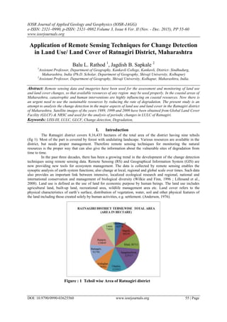
  • 1. IOSR Journal of Applied Geology and Geophysics (IOSR-JAGG) e-ISSN: 2321–0990, p-ISSN: 2321–0982.Volume 3, Issue 6 Ver. II (Nov. - Dec. 2015), PP 55-60 www.iosrjournals.org DOI: 10.9790/0990-03625560 www.iosrjournals.org 55 | Page Application of Remote Sensing Techniques for Change Detection in Land Use/ Land Cover of Ratnagiri District, Maharashtra Balu L. Rathod 1 , Jagdish B. Sapkale 2 1 Assistant Professor, Department of Geography, Kankavli College, Kankavli, District- Sindhudurg, Maharashtra, India (Ph.D. Scholar, Department of Geography, Shivaji University, Kolhapur) 2 Assistant Professor, Department of Geography, Shivaji University, Kolhapur, Maharashtra, India. Abstract: Remote sensing data and imageries have been used for the assessment and monitoring of land use and land cover changes, so that available resources of any region may be used properly. In the coastal areas of Maharashtra, catastrophic and human interventions are highly influencing on coastal resources. Now there is an urgent need to use the sustainable resources by reducing the rate of degradation. The present study is an attempt to analysis the change detection in the major aspects of land use and land cover in the Ratnagiri district of Maharashtra. Satellite images of the years 1989, 1999 and 2009 have been obtained from Global Land Cover Facility (GLCF) & NRSC and used for the analysis of periodic changes in LULC of Ratnagiri. Keywords: LISS-III, LULC, GLCF, Change detection, Degradation, I. Introduction The Ratnagiri district covers 8,16,433 hectares of the total area of the district having nine tehsils (fig 1). Most of the part is covered by forest with undulating landscape. Various resources are available in the district, but needs proper management. Therefore remote sensing techniques for monitoring the natural resources is the proper way that can also give the information about the vulnerable sites of degradation from time to time. In the past three decades, there has been a growing trend in the development of the change detection techniques using remote sensing data. Remote Sensing (RS) and Geographical Information System (GIS) are now providing new tools for ecosystem management. The data is collected by remote sensing enables the synoptic analysis of earth system functions; also change at local, regional and global scale over times. Such data also provides an important link between intensive, localized ecological research and regional, national and international conservation and management of biological diversity (Wilkie and Finn, 1996 ; Lillesand et al., 2008). Land use is defined as the use of land for economic purpose by human beings. The land use includes agricultural land, built-up land, recreational area, wildlife management area etc. Land cover refers to the physical characteristics of earth‟s surface, distribution of vegetation, water, soil and other physical features of the land including those created solely by human activities, e.g. settlement. (Anderson, 1976). Figure : 1 Tehsil wise Area of Ratnagiri district
  • 2. Application of Remote Sensing Techniques for Change Detection in Land Use/ Land Cover… DOI: 10.9790/0990-03625560 www.iosrjournals.org 56 | Page Land use refers to the purpose of land reserves, for example, recreation, wildlife habitat or agriculture. Land use applications involve both baseline mapping and subsequent monitoring, since timely information is required to know the current quantity of land and the type of its usage and to identify the land use changes from year to year. Satellite remote sensing data i.e. images and soft data is the most common data source for change detection, quantification, and mapping of LULC patterns and variations can be easily detected due to its repetitive data acquisition, digital format suitable for computer processing, and accurate georeferencing procedures (Anderson, 1976; Chen, Vierling, & Deering, 2005; Jensen, 2005; ). Change detection is the process of identifying differences in the state of an object or phenomenon by observing it at different times. Essentially, it involves the ability to quantify temporal effects using multi-temporal data sets. One of the major applications of remotely-sensed data obtained from Earth-orbiting satellites is change detection because of repetitive coverage at short intervals and consistent image quality (Anderson, 1976). Amount of degradation can be easily accessed using these advances tools and techniques ( Sapkale & Rathod, 2014; 2015). II. Data And Methods Land use and land cover classification through supervised classification methods by using LANDSAT, TM , Satellite image of Ratnagiri Coastal Resource for the years 1989 has been performed/ done. LANDSAT, ETM, Satellite image of Ratnagiri Coastal Resource 1999 and LISS-III Satellite image of Ratnagiri Coastal Resource 2009 were also used to carry out change detection analysis. Satellite images of the years 1989, 1999 and 2009 have been obtained from Global Land Cover Facility (GLCF) & NRSC. The resolution was 30 meters for Landsat data and 23.5 m. LISS III image. The Land Use/ Land Cover classification has been performed through supervised classification method using Digital Image Processing software. Erdas Imagine and ArcGIS software are powerful tools for extracting the land use and land cover layers from Ratnagiri Coastal Resource. III. Discussions And Results LAND USE / LAND COVER MAPPING AND CHANGE ANALYSIS: The land use and land cover classes includes agricultural land, vegetation, built up area, water bodies and fallow land. It is the broad classification of the land use and land cover of study area. CROPPED AREA: The cropped land may be defined broadly as land that is used primarily for production of food and fodder. Cropped land occupies sizeable area. Rice, Vegetables are the major crops in this region. In the year 1989 the cropped land is covered by 7.21% of the total area under these categories. In 1999 about 11.65% of the total area is under cropped in this region. In 2009 about 13.47% of the total area is under cropped in this region. In Ratnagiri district the cropped area has increased by 1.82% in 20 years from 1989 to 2009. There is a positive change in agricultural land in these 20 years (table no. 1 to 5). BUILTUP AREA :The built-up land cover is reported from Ratnagiri district in the year of 1989 is 0.10%. The total area covered by built-up land in the years 1999 and 2009 is 0.59% and 2.46% respectively. It can be observed that in these 20 years, from 1989 to 2009 the builtup area has increased by 1.87%. There is a positive change in builtup land in these 20 years. Table No. 1 LAND USE / LAND COVER CLASSIFICATION IMAGE-YEAR-1989 Sr. No Class Name Area in Hectare Area in Percentage% 1 Built-up 10623 0.10 2 Cropped 757809 7.21 3 Open land 2128305 20.26 4 Dense forest 339202 3.22 5 Sparse forest 6671676 63.52 6 Water body 218784 2.08 7 Barren land 375732 3.57 Total Area 10502131 100
  • 3. Application of Remote Sensing Techniques for Change Detection in Land Use/ Land Cover… DOI: 10.9790/0990-03625560 www.iosrjournals.org 57 | Page Source:- Based on Global Land Cover Facility (GLCF)
  • 4. Application of Remote Sensing Techniques for Change Detection in Land Use/ Land Cover… DOI: 10.9790/0990-03625560 www.iosrjournals.org 58 | Page
  • 5. Application of Remote Sensing Techniques for Change Detection in Land Use/ Land Cover… DOI: 10.9790/0990-03625560 www.iosrjournals.org 59 | Page OPEN LAND AREA : In the Ratnagiri district some area covered with open land. The open land refers the land may be uncultivated and unused land. In the year of 1989, the open land has occupied 22.92% of total area of region. From 1999 to 2009, it is 22.92% and 11.17% respectively. In Ratnagiri district the open land area has decreased by -11.75% in 20 years from 1989 to 2009. There is a negative change in open land area in these 20 years. DENSE FOREST AREA : The area under forest includes the land classified as forest under any legal enactment dealing with forest or administrated for forest, whether state-owned or private, and whether wooded or maintained as potential forest land. The areas where crops are raised in the forests and grazing lands or areas open for grazing within the forests are included under forest area (National Commission on Agriculture, 1976). The present Ratnagiri district is located in coastal and hilly region with uneven topography covered by dense vegetation. Most of the area is under dense forests. Table No. 2 LAND USE / LAND COVER CLASSIFICATION IMAGE-YEAR-1999 Sr. No Class Name Area in Hectare Area in Percentage% 1 Builtup 59722 0.59 2 Cropped 1171164 11.65 3 Open land 2302773 22.92 4 Dense forest 826064 8.22 5 Sparse forest 5337999 53.13 6 Water body 159428 1.58 7 Barren land 188264 1.87 Total Area 10045414 100 Table No. 3 LAND USE / LAND COVER CLASSIFICATION IMAGE-YEAR-2009 Sr. No Class Name Area in Hectare Area in Percentage% 1 Builtup 237421 2.45 2 Cropped 1298500 13.44 3 Open land 1077218 11.15 4 Dense forest 601475 6.22 5 Sparse forest 6008559 62.20 6 Water body 125540 1.29 7 Barren land 310192 3.21 Total Area 9658905 100 Table No. 4 LAND USE/ LAND COVER CHANGE FROM 1989 TO 1999 Year-1989 Year-1999 Difference Change (1989 to 1999) Sr. No Class Name Area in Hectare Area in % Area in Hectare Area in % Area in Hectare Area in % 1 Builtup 10623 0.10 59722 0.59 49099 0.49 2 Cropped 757809 7.21 1171164 11.65 413355 4.44 3 Open land 2128305 20.26 2302773 22.92 174468 2.66 4 Dense forest 339202 3.22 826064 8.22 486862 5.00 5 Sparse forest 6671676 63.52 5337999 53.13 -1333677 -10.39 6 Water body 218784 2.08 159428 1.58 -59356 -0.5 7 Barren land 375732 3.57 188264 1.87 -187468 -1.7 Total Area 10502131 100 10045414 100
  • 6. Application of Remote Sensing Techniques for Change Detection in Land Use/ Land Cover… DOI: 10.9790/0990-03625560 www.iosrjournals.org 60 | Page In 1989, the dense forest area cover was 3.22% of the total area in study region. In 1999 and 2009 the area of Ratnagiri district under dense forest area cover was 8.22% and 6.23% respectively. It can be observed that in these 20 years, almost -1.99% dense forest area cover has decreased in the study region. There is a negative change in dense forest area in these 20 years. SPARSE FOREST AREA: The present Ratnagiri district is located in coastal and hilly region with uneven topography covered by sparse vegetation. Most of the area is under sparse forests. In 1989, the sparse forests cover was 63.52% of the total area in the study region. In 1999 and 2009 the area of Ratnagiri district under sparse forests cover was 53.13% and 62.13% respectively. It can be observed that in these 20 years, almost 9.00% sparse forests area cover has increased in the study region. There is a positive change in sparse forests area cover in these 20 years. WATER BODY: Water bodied includes estuary, wells, lakes, ponds, river and stream. The percentage of water bodies in the region is 2.08% of the total area in the year 1989. The total area covered by water bodies in the years 1999 and 2009 was 1.58% and 1.50% respectively. The area under water bodies in Ratnagiti district has decreased increased from 1989 to 2009 by -0.08%. There is a negative change in dense forest area in these 20 years. BARREN LAND: The Barren land cover is reported from Ratnagiri district in the year of 1989 is 3.57%. The total area covered by barren land in the years 1999 and 2009 is 1.87% and 3.01% respectively. In Ratnagiri district the barren land area has increased by 1.14% in 20 years from 1989 to 2009. There is a positive change in barren land area in these 20 years. IV. Conclusion Updated information about land use and land cover of the present study area will help to overcome the problems in connection with the agricultural systems, forest cover, various infrastructures etc. Therefore it has suggested that, Remote sensing, GIS, GPS techniques should be used continuously for the management and development in the study area. References [1] Anderson, James Richard. A land use and land cover classification system for use with remote sensor data. Vol. 964. US Government Printing Office, 1976. [2] Chen, X., Vierling, L., & Deering, D., A simple and effective radiometric correction method to improve landscape change detection across sensors and across time. Remote Sensing of Environment, 98(1), 63-79, 2005. [3] Jensen, J. R. (2005). Introductorydigitalimageprocessing:Aremotesensingperspective (3rd Edn). Upper SaddleRiver, NJ:Prentice-Hall,2005. [4] Lillesand, M.T., KIefer, W. R. andChipman, N, J. (2008). :Remotesensingand image interpretation (6th ed). JohnWileyand Sons, Inc, NewYork.. [5] Rathod, B.L, (2015) , “ Coastal Resource Management Using Remote Sensing and GIS Techniques: A Case Study of Ratnagiri District, Maharashtra, (2015), Unpublished Ph.D. Dissertation. [6] Rathod, B. L., Sapkale, J.B., Status ofAgriculture in Coastal Villages of Ratnagiri, Maharashtra.,. ,International Journal of Scientific and Engineering Research, (IJSER), 6(9),1556-15592015. [7] Sapkale, J.B., Rathod, B. L., “Kharlands-An Agrarian Disaster in CoastalAreas of Southern Ratnagiri, Maharashtra:AStudy Using Remote Sensing and GIS”, InternationalRefereedJournalofEngineeringand Science (IRJES),3(6),71-78, 2014. [8] Socio-economic Review and Statistical Abstract Ratnagiri District 1980-2013. [9] Wilkie, D.S. and Finn, J.T. : „Remote Sensing Imagery for Natural Resources Monitoring‟. Columbia University Press, New York., P.P.- 295. 1996. Table No. 5 LAND USE/ LAND COVER CHANGE FROM 1999 TO 2009 Year-1999 Year-2009 Difference Change (1999 to 2009) Sr. No Class Name Area in Hectare Area in % Area in Hectare Area in % Area in Hectare Area in % 1 Builtup 59722 0.59 237421 2.46 177699 1.87 2 Cropped 1171164 11.65 1298500 13.47 127336 1.82 3 Open land 2302773 22.92 1077218 11.17 -1225555 -11.75 4 Dense forest 826064 8.22 601475 6.23 -224589 -1.99 5 Sparse forest 5337999 53.13 5989325 62.13 651326 9.00 6 Water body 159428 1.58 144776 1.50 -14652 -0.08 7 Barren land 188264 1.87 290864 3.01 102600 1.14 Total Area 10045414 100 9639579 100