Downloaded 78 times
![Land Use /Land Cover Classification and Change Detection Using Geographical Information
System: A Case Study
http://www.iaeme.com/IJCIET/index.asp 335 editor@iaeme.com
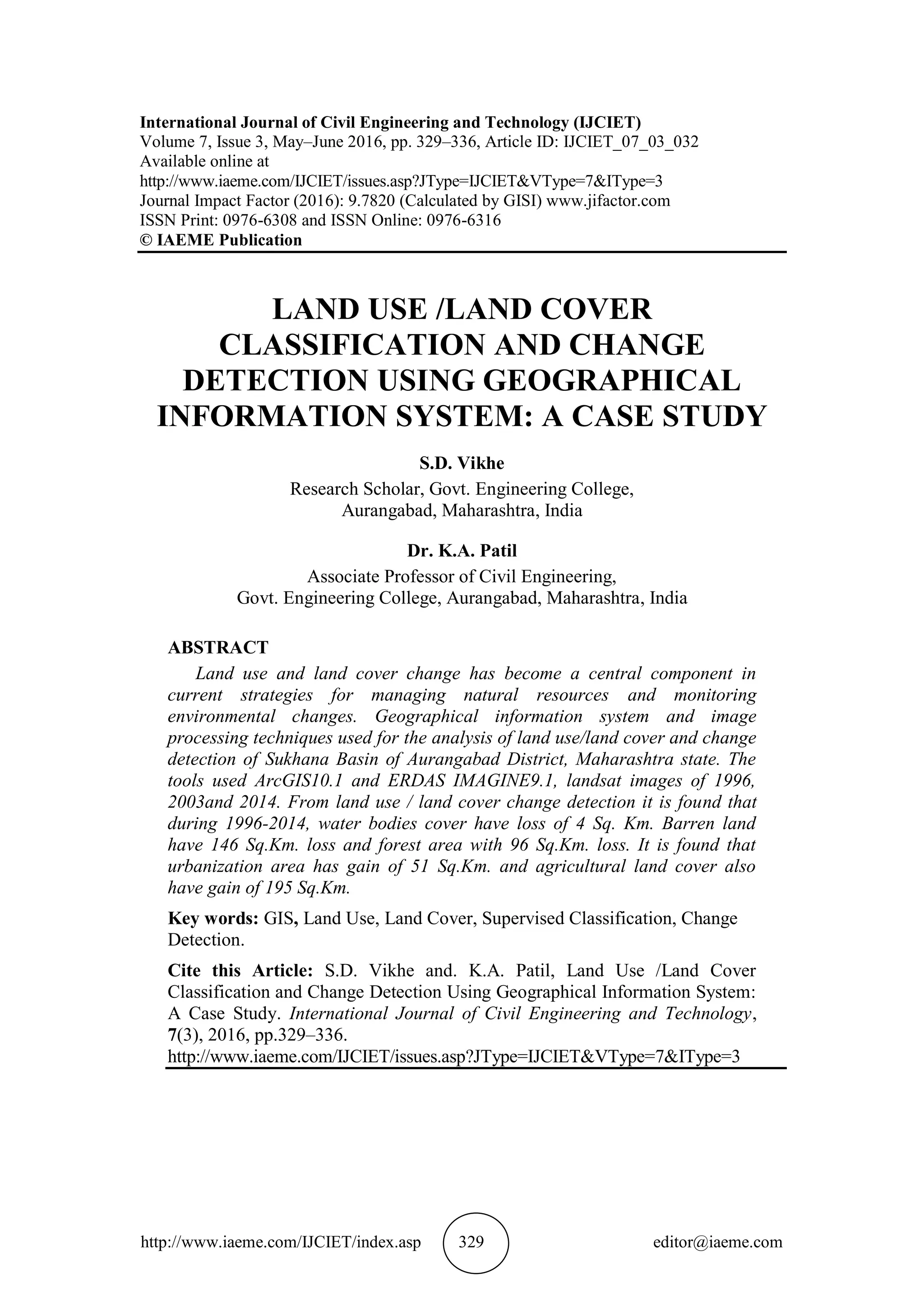
Figure 2 Land use/land cover maps of Sukhana Basin in 1996, 2003 and 2014.
The assessment of the accuracy of classification found by ratio of the mapped area
that has been correctly classified in comparison to reference data such as toposheet ,
reconnaissance survey ground truth to the total area mapped. The accuracy found to
be 85 %.
4. CONCLUSION
From study of land use / land cover change detection ,it is found that during 1996-
2014, water bodies cover have loss of 4 Sq. Km. Barren land have 146 Sq.Km. loss
and forest area with 96 Sq.Km. loss. It is found that urbanization area has gain of 51
Sq.Km. and agricultural land cover also have gain of 195 Sq.Km. Land use / land
cover must be improved with reference to resource management and application of
conservation treatment in the basin.
REFERENCES
[1] Sudhir Mahajan, Pankaj Panwar And Deepak Kaundal (2001). GIS Application to
Determine the Effect of Topography on Landuse in Ashwani Khad Watershed.
Journal of the Indian Society of Remote Sensing, 29,(4), pp.243–248 .
[2] Bisht B S and B P Kothyari (2002). Land-Cover Change Analysis of Garur
Ganga Watershed Using GIS/Remote Sensing Technique, Journal of the Indian
Society of Remote Sensing, 29(3). Pp. 138–141.
[3] Jayakumar S. and D.I. Arockiasamy (2003), Land use/Land Cover Mapping and
Change Detection in part of Eastern Ghats of Tamil Nadu using Remote Sensing
and GIS. Journal of the Indian Society of Remote Sensing, 31(4), pp.252–260
[4] Genxu Wang, Yibo Wang and Jumpei Kubota.(2006), Land-Cover Changes and
Its Impacts On Ecological Variables In The Headwaters Area of the Yangtze
River, China.” Journal of Environmental Monitoring and Assessment Springer
120, pp. 361–385.
[5] Herold, M., Latham, J.S., Di Gregorio, A., and Schmullius, C.C. (2006) Evolving
Standards in Land Cover Characterization. Journal of Land Use Science, 1(2–4),
pp. 157–168.
[6] Yu, H., Joshi, P.K., Das, K.K., Chauniyal, D.D., Melick D.R., Yang, X., and Xu,
J. (2007) Land Use/ Cover Change and Environmental Vulnerability Analysis in
Birahi Ganga Sub-Watershed of Garhwal Himalaya. Tropical Ecology, 48(2), pp.
241-250.](https://image.slidesharecdn.com/ijciet0703032-160727142003/85/LAND-USE-LAND-COVER-CLASSIFICATION-AND-CHANGE-DETECTION-USING-GEOGRAPHICAL-INFORMATION-SYSTEM-A-CASE-STUDY-7-320.jpg)
![S.D. Vikhe and K.A. Patil
http://www.iaeme.com/IJCIET/index.asp 336 editor@iaeme.com
[7] Boakye, E., Odai, S.N., Adjei, K.A., and Annor, F.O. (2008) Landsat Images for
Assessment of the Impact of Land Use and Land Cover changes on the Barekese
.Catchment in Ghana. European Journal of Scientific Research, 22(2), pp. 269-
278.
[8] Chaudhary, B.S., Saroha, G.P., and Yadav, M. (2008) Human Induced Land Use
Land Cover Changes in Northern Part of Gurgaon District, Haryana, India:
Natural Resources Census oncept. Journal of Human Ecology, 23(3), pp. 243-
252.
[9] Bazgeera S., P.K. Sharmab, R.K. Maheya, S.S. Hundala, A. Soodb (2008).
“Assessment of land use changes using remote sensing and GIS and their
implications on climatic variability for Balachaur watershed in Punjab, India.
DESERT Online at http://jdesert.ut.ac.ir 12, 139–147.
[10] Sathees kumar P, Nisha Radhakrishnan (2010), Remote Sensing and Gis in Land
Use Planning, 11th ESRI India User Conference 2010. Pp. 1–7.
[11] He-Bing Hu, Hong-Yu Liu, Jing-Feng Hao Jing An. (2012), Analysis of Land
Use Change Characteristics Based On Remote Sensing And Gis In The Jiuxiang
River Watershed, International Journal On Smart Sensing and Interlligent
Systems, 5(4).
[12] Kotoky, P. M. K. Dutta and G. C. Borah (2012), Changes in Landuse and
Landcover along the Dhansiri River Channel, Assam – A Remote Sensing and
GIS Approach, Journal Geological Society of India Volume 79, pp.61–68.
[13] Jeffry Swingly Frans Sumarauw, and Koichiro Ohgushi (2012), Analysis On
Curve Number, Land Use And Land Cover Changes In The Jobaru River Basin,
Japan, ARPN Journal of Engineering and Applied Sciences 7(7), pp. 1819–6608.
[14] Singh R B and Dilip Kumar (2012), Remote sensing and GIS for land use/cover
mapping and integrated land management: case from the middle Ganga plain
Journal of Front. Earth Sci. (Springer), 6(2): pp.167–176.
[15] Wagner, P. D. S. Kumar, and K. Schneider (2013), An assessment of land use
change impacts on the water resources of the Mula and Mutha Rivers catchment
upstream of Pune, India, Journal of Hydrology and Earth System. Science., Vol.
17, pp.2233–2246,
[16] Praveen KumarMallupattu and Jayarama Reddy Sreenivasula Reddy. (2013).
“Analysis of Land Use/Land Cover Changes Using Remote Sensing Data and
GIS at an Urban Area, Tirupati, India, Scientific world Journal Hindawi
Publishing Corporation The Vol 02013, pp.107.
[17] Mani.N. and Rama Krishnan. (2013). Assessment of Changes In Land Use/ Land
Cover In Tamil Nadu State In India Using GIS, African Journal of Science and
Research 2(6): pp : 01-06.
[18] W.A. Siahaya, P. Danoedoro, N. Khakhim, M. Baiquni.(2015) The comparison
analysis of land cover change based on vegetation index and multispectral
classification (a case study at Leihitu Peninsula of Ambon City District). Journal
of Degraded Andmining Landsmanagement, Volume 29 (4), pp. 415 – 422.
[19] Amare Sewnet (2016) Land use/cover change at Infraz watershed by using GIS
and remote sensing techniques, Northwestern Ethiopia, Intl. J. River Basin
Management 14(2), pp. 133–142.
[20] Prof. Dr. Mohammad A. Alanbari Asst. Prof. Saif S. Alquzweeni and Rusul A.
Aldaher, Spatial Distribution Mapping For Various Pollutants of Al-Kufa River
Using Geographical Information System (GIS). International Journal of Civil
Engineering and Technology, 6(10), 2015, pp.1–14.](https://image.slidesharecdn.com/ijciet0703032-160727142003/85/LAND-USE-LAND-COVER-CLASSIFICATION-AND-CHANGE-DETECTION-USING-GEOGRAPHICAL-INFORMATION-SYSTEM-A-CASE-STUDY-8-320.jpg)

The study analyzes land use and land cover changes in the Sukhana basin of Aurangabad district, Maharashtra, between 1996 and 2014 using GIS and remote sensing techniques. Findings indicate significant losses in water bodies (4 sq. km), barren land (146 sq. km), and forest area (96 sq. km), alongside gains in urbanization (51 sq. km) and agricultural land (195 sq. km). The research highlights the impacts of urbanization and agriculture on local ecosystems and emphasizes the need for improved resource management.