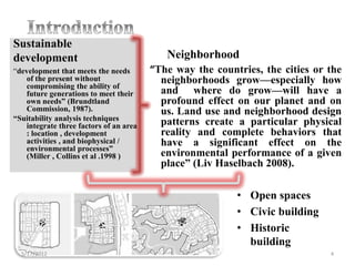
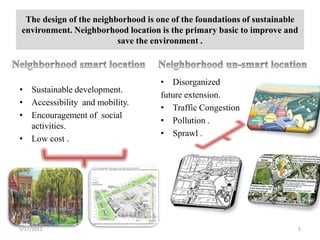
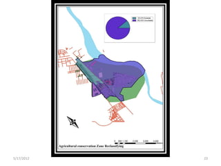
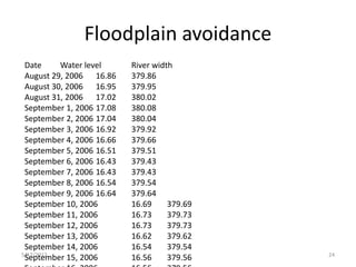
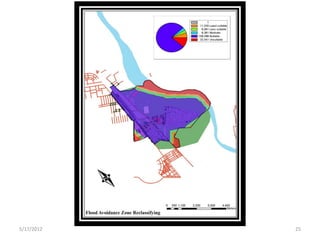
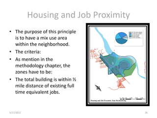
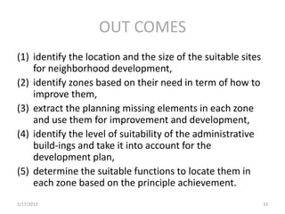
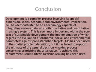
5/17/2012   1
STUDEN NAME :RAFIF HATIM ABDELMALIK

                          MAY 2012


5/17/2012                                         2
•   Introduction
•   Aim
•   Objective
•    Soba
•   LEED-ND, GIS, MCDM
•   Out comes


5/17/2012                3
Sustainable
development                                Neighborhood
“development that meets the needs       “The way the countries, the cities or the
   of the present without                 neighborhoods grow—especially how
   compromising the ability of
   future generations to meet their       and where do grow—will have a
   own needs” (Brundtland                 profound effect on our planet and on
   Commission, 1987).                     us. Land use and neighborhood design
“Suitability analysis techniques
   integrate three factors of an area     patterns create a particular physical
   : location , development               reality and complete behaviors that
   activities , and biophysical /         have a significant effect on the
   environmental processes”
   (Miller , Collins et al .1998 )        environmental performance of a given
                                          place” (Liv Haselbach 2008).

                                                          • Open spaces
                                                          • Civic building
                                                          • Historic
                                                            building
  5/17/2012                                                                   4
The design of the neighborhood is one of the foundations of sustainable
environment. Neighborhood location is the primary basic to improve and
                         save the environment .


                                    • Disorganized
• Sustainable development.
                                    future extension.
• Accessibility and mobility.
                                    • Traffic Congestion
• Encouragement of social
                                    • Pollution .
  activities.
                                    • Sprawl .
• Low cost .


5/17/2012                                                              5
• Sustainable planning needs sustainable identification for
        differ of function within redevelopment areas.
      • Each area background need special criteria


5/17/2012                                                       6
The aim of this paper is to develop a guide line for the new
development of neighborhoods by integrating smart neighborhood
location analysis with geographic information system (GIS) technology
in order to be more sustainable in (Soba).


5/17/2012                                                           7
• Assess the present and the future growth of Soba’s
  neighborhoods with regard to smart location principles.

• Determine the guidelines for the sustainable development.

• To generate a scenarios of the smart location by
  integrating analysis with geographic information system
  technology.


5/17/2012                                                   8
Soba


                         The world's longest river, the Nile , divides the
                         country between east and west sides. It is generally
                         flat plains, broken by several mountain ranges


            Officially the Republic of the( Sudan) is a country in
            northeastern Africa. It is the largest country in Africa and
            in the Arab World, and tenth largest in the world by area.


5/17/2012                                                                  9
•  Metropolitan Khartoum, which comprises Khartoum, Khartoum
  North and Omdurman, has an area of 802.5 km2. It is located at the
  point where the White Nile, flowing north from Uganda, meets the
  Blue Nile, flowing west from Ethiopia. Soba is an existing
  neighborhood in Khartoum the capital of Sudan
• Within the past century, the city has expanded 250 times in area and
  114 times in population. The population of metropolitan Khartoum
  is now estimated to be more than five million, ( Babiker, B. ,2003) .
  The capital is sprawling rather than dense: population density in
  metropolitan Khartoum was estimated at approx imately 163
  persons/km² in 2004.
• Four master plans have been established for the development of
  Khartoum since independence. Most were only partially
  implemented, and a new plan is currently in process.( Abdulhafeez
  Awad Hafazalla,2008)


5/17/2012                                                            10
• Soba is located on west ( 15.6040 N, 32.5298E) .It is about
  17.4 km straight line from Khartoum .Soba is a previous
  neighborhood area which now a days , has a huge new planned
  and unplanned development movement. There are many
  different functions of building located in that neighborhood
  such as Solar Energy Research , Sport city , Soba hospital ,
  Main hospital for the heart disease , and many new housing
  settlement
• The population in Soba around 170.000. The first tribes lived
  on Soba were Jaleen , shyqia and rofaaeen. Now a day’s Soba
  is a model of the good live hood and relation between the
  citizens. The Crawl population is heading towards in Soba . (
  Sudan Post-CONFLICT ENVIRONMENTA ASSESSMENT,
  2008)


5/17/2012                                                     11
The scope of this work is to define the principles for the
   neighborhood smart location to fulfill them in Soba area in the
   south part of Khartoum. Studying Soba to assess the smart
   location presently and the next 10 years in term of sustainable
   environment, economy and society . Install our analysis in the
   GIS software to get accurate and faster result .Using the
   software to determine a model for the neighborhood smart
   location.


5/17/2012                                                        12
LEED-ND
                       There is no consensus on what makes a
                       neighborhood sustainable or how to measure
                       the sustainability of urban form (Garde, 2009).
            GIS


              MCDM
                       Multi-criteria decision making methods are
                       conventional methods that assist decision
                       makers to analyze and solve numerous criteria
                       decision problems.


5/17/2012                                                                13
Principles


                                 Methodology
                    Using overlay technique, the area can be
                    classified into suitable, moderate and
                    unsuitable zones as they fulfill different level of
                    the LEED-ND principles and criteria.


            Accurate result
            The Analytic hierarchy process (AHP) was
            adopted to further examine the suitability of
            the criteria. The paper concludes with
            discussion on how LEED-ND can be adopted to
            suit the development of the study area.
5/17/2012                                                       14
LEED-ND
•   Smart Location.
•   Imperiled Species and Ecological Communities.
•   Wetland and Water body Conservation.
•   Agricultural Land Conservation.
•   Floodplain Conservation.
•   Housing and Job Proximity.
•   Steep Slope Protection.
•   Street network.
5/17/2012                                           15
5/17/2012   16
Smart Location
•           “Infill site, or
•         Adjacent site with
connectivity on development
land , or
•         Transit corridor or
route with adequate transit
service , or
•          Site with nearby
neighborhood assets” (Congress
for the New Urbanism, 2009).


5/17/2012                                       17
5/17/2012   18
Implied Species and Ecological
                    Communities
• The site has to be free from Species or
  ecological community or, it will be need
  treatment conservation. The study area has
  no special species or communities except in
  the land that used for agriculture which need
  to be conserved. Thus for the study area the
  agriculture land will be delivered.


5/17/2012                                         19
5/17/2012   20
Wetland and Water Body Conservation
• The conservation zone is 100 feet
  (30.48 meter) around the water
  body and 50 feet of the wetland
  based on LEED-ND 2009. The
  wetland and water body
  conservation is the result of using
  the overlay tools by buffering 100
  feet around the Nile revier.
  Convertor tools has used to get
  the raster layer and reclassified
  by the raster reclassifying rater
  function.


5/17/2012                               21
Agricultural Land Conservation
• Soil type


5/17/2012                               22
5/17/2012   23
Floodplain avoidance
 Date     Water level      River width
 August 29, 2006 16.86     379.86
 August 30, 2006 16.95     379.95
 August 31, 2006 17.02     380.02
 September 1, 2006 17.08   380.08
 September 2, 2006 17.04   380.04
 September 3, 2006 16.92   379.92
 September 4, 2006 16.66   379.66
 September 5, 2006 16.51   379.51
 September 6, 2006 16.43   379.43
 September 7, 2006 16.43   379.43
 September 8, 2006 16.54   379.54
 September 9, 2006 16.64   379.64
 September 10, 2006        16.69     379.69
 September 11, 2006        16.73     379.73
 September 12, 2006        16.73     379.73
 September 13, 2006        16.62     379.62
 September 14, 2006        16.54     379.54
5/17/2012                                     24
 September 15, 2006        16.56     379.56
5/17/2012   25
Housing and Job Proximity
• The purpose of this principle
  is to have a mix use area
  within the neighborhood.
• The criteria:
• As mention in the
  methodology chapter, the
  zones have to be:
• The total building is within ½
  mile distance of existing full
  time equivalent jobs.


5/17/2012                               26
Street Network
• It is the zone with
  street intersects on
  site boundary at least
  every 400 feet .This
  will encourage the
  daily physical life and
  decrease the MVT.


5/17/2012                      27
MCDM
• These methods have been evolved since 1950 to help
  decision makers in either ranking a known set of
  alternatives for prob-lem or making a choice among
  this set while considering the conflicting criteria.
• According to Saaty . T. L. (2003), making a ranking
  questionnaire for the principles was the first step.
  Taking those output data and set them in the Expert
  Choice software to get the weight of each principle by
  setting the pairwise has done as the third step. There is
  a scale for the pairwise according to Saaty (1980).


5/17/2012                                                 28
Principle                   Rate   Weight
                    Smart location              3      0.150
                    Wetland and         water   5      0.117
            body conservation
                    Slope protection            2      0.049
                    Flood avoidance             5      0.032
                    Street network              5      0.084
                    Housing       and     job   5      0.060
            proximity
                    Agriculture                 2      0.215
            conservation
                    Site selection              2      0.267
                    Imperiled        species    2      0.026
            protection


5/17/2012                                                       29
5/17/2012   30
5/17/2012   31
5/17/2012   32
OUT COMES
(1) identify the location and the size of the suitable sites
    for neighborhood development,
(2) identify zones based on their need in term of how to
    improve them,
(3) extract the planning missing elements in each zone
    and use them for improvement and development,
(4) identify the level of suitability of the administrative
    build-ings and take it into account for the
    development plan,
(5) determine the suitable functions to locate them in
    each zone based on the principle achievement.
5/17/2012                                                      33
Conclusion
Development is a complex process involving its special
dimension, social, economic and environmental implication.
GIS has demonstrated to be a technology capable of
integrating various data sets both qualitative and quantitative
in a single system. This is even more important within the con-
text of sustainable development the implementation of which
regards the evaluation of economic, social, and environmental
parameters against pre-established targets. GIS has been used
in the spatial problem definition, but it has failed to support
the ultimate of the general decision –making process
concerning prioritizing the alternative. To achieve this
requirement, Multi Criteria Decision Making has been used.


5/17/2012                                                    34
5/17/2012   35

Abdelmalik - input2012

  • 1.
  • 2.
    STUDEN NAME :RAFIFHATIM ABDELMALIK MAY 2012 5/17/2012 2
  • 3.
    Introduction • Aim • Objective • Soba • LEED-ND, GIS, MCDM • Out comes 5/17/2012 3
  • 4.
    Sustainable development Neighborhood “development that meets the needs “The way the countries, the cities or the of the present without neighborhoods grow—especially how compromising the ability of future generations to meet their and where do grow—will have a own needs” (Brundtland profound effect on our planet and on Commission, 1987). us. Land use and neighborhood design “Suitability analysis techniques integrate three factors of an area patterns create a particular physical : location , development reality and complete behaviors that activities , and biophysical / have a significant effect on the environmental processes” (Miller , Collins et al .1998 ) environmental performance of a given place” (Liv Haselbach 2008). • Open spaces • Civic building • Historic building 5/17/2012 4
  • 5.
    The design ofthe neighborhood is one of the foundations of sustainable environment. Neighborhood location is the primary basic to improve and save the environment . • Disorganized • Sustainable development. future extension. • Accessibility and mobility. • Traffic Congestion • Encouragement of social • Pollution . activities. • Sprawl . • Low cost . 5/17/2012 5
  • 6.
    • Sustainable planningneeds sustainable identification for differ of function within redevelopment areas. • Each area background need special criteria 5/17/2012 6
  • 7.
    The aim ofthis paper is to develop a guide line for the new development of neighborhoods by integrating smart neighborhood location analysis with geographic information system (GIS) technology in order to be more sustainable in (Soba). 5/17/2012 7
  • 8.
    • Assess thepresent and the future growth of Soba’s neighborhoods with regard to smart location principles. • Determine the guidelines for the sustainable development. • To generate a scenarios of the smart location by integrating analysis with geographic information system technology. 5/17/2012 8
  • 9.
    Soba The world's longest river, the Nile , divides the country between east and west sides. It is generally flat plains, broken by several mountain ranges Officially the Republic of the( Sudan) is a country in northeastern Africa. It is the largest country in Africa and in the Arab World, and tenth largest in the world by area. 5/17/2012 9
  • 10.
    • MetropolitanKhartoum, which comprises Khartoum, Khartoum North and Omdurman, has an area of 802.5 km2. It is located at the point where the White Nile, flowing north from Uganda, meets the Blue Nile, flowing west from Ethiopia. Soba is an existing neighborhood in Khartoum the capital of Sudan • Within the past century, the city has expanded 250 times in area and 114 times in population. The population of metropolitan Khartoum is now estimated to be more than five million, ( Babiker, B. ,2003) . The capital is sprawling rather than dense: population density in metropolitan Khartoum was estimated at approx imately 163 persons/km² in 2004. • Four master plans have been established for the development of Khartoum since independence. Most were only partially implemented, and a new plan is currently in process.( Abdulhafeez Awad Hafazalla,2008) 5/17/2012 10
  • 11.
    • Soba islocated on west ( 15.6040 N, 32.5298E) .It is about 17.4 km straight line from Khartoum .Soba is a previous neighborhood area which now a days , has a huge new planned and unplanned development movement. There are many different functions of building located in that neighborhood such as Solar Energy Research , Sport city , Soba hospital , Main hospital for the heart disease , and many new housing settlement • The population in Soba around 170.000. The first tribes lived on Soba were Jaleen , shyqia and rofaaeen. Now a day’s Soba is a model of the good live hood and relation between the citizens. The Crawl population is heading towards in Soba . ( Sudan Post-CONFLICT ENVIRONMENTA ASSESSMENT, 2008) 5/17/2012 11
  • 12.
    The scope ofthis work is to define the principles for the neighborhood smart location to fulfill them in Soba area in the south part of Khartoum. Studying Soba to assess the smart location presently and the next 10 years in term of sustainable environment, economy and society . Install our analysis in the GIS software to get accurate and faster result .Using the software to determine a model for the neighborhood smart location. 5/17/2012 12
  • 13.
    LEED-ND There is no consensus on what makes a neighborhood sustainable or how to measure the sustainability of urban form (Garde, 2009). GIS MCDM Multi-criteria decision making methods are conventional methods that assist decision makers to analyze and solve numerous criteria decision problems. 5/17/2012 13
  • 14.
    Principles Methodology Using overlay technique, the area can be classified into suitable, moderate and unsuitable zones as they fulfill different level of the LEED-ND principles and criteria. Accurate result The Analytic hierarchy process (AHP) was adopted to further examine the suitability of the criteria. The paper concludes with discussion on how LEED-ND can be adopted to suit the development of the study area. 5/17/2012 14
  • 15.
    LEED-ND • Smart Location. • Imperiled Species and Ecological Communities. • Wetland and Water body Conservation. • Agricultural Land Conservation. • Floodplain Conservation. • Housing and Job Proximity. • Steep Slope Protection. • Street network. 5/17/2012 15
  • 16.
  • 17.
    Smart Location • “Infill site, or • Adjacent site with connectivity on development land , or • Transit corridor or route with adequate transit service , or • Site with nearby neighborhood assets” (Congress for the New Urbanism, 2009). 5/17/2012 17
  • 18.
  • 19.
    Implied Species andEcological Communities • The site has to be free from Species or ecological community or, it will be need treatment conservation. The study area has no special species or communities except in the land that used for agriculture which need to be conserved. Thus for the study area the agriculture land will be delivered. 5/17/2012 19
  • 20.
  • 21.
    Wetland and WaterBody Conservation • The conservation zone is 100 feet (30.48 meter) around the water body and 50 feet of the wetland based on LEED-ND 2009. The wetland and water body conservation is the result of using the overlay tools by buffering 100 feet around the Nile revier. Convertor tools has used to get the raster layer and reclassified by the raster reclassifying rater function. 5/17/2012 21
  • 22.
    Agricultural Land Conservation •Soil type 5/17/2012 22
  • 23.
  • 24.
    Floodplain avoidance Date Water level River width August 29, 2006 16.86 379.86 August 30, 2006 16.95 379.95 August 31, 2006 17.02 380.02 September 1, 2006 17.08 380.08 September 2, 2006 17.04 380.04 September 3, 2006 16.92 379.92 September 4, 2006 16.66 379.66 September 5, 2006 16.51 379.51 September 6, 2006 16.43 379.43 September 7, 2006 16.43 379.43 September 8, 2006 16.54 379.54 September 9, 2006 16.64 379.64 September 10, 2006 16.69 379.69 September 11, 2006 16.73 379.73 September 12, 2006 16.73 379.73 September 13, 2006 16.62 379.62 September 14, 2006 16.54 379.54 5/17/2012 24 September 15, 2006 16.56 379.56
  • 25.
  • 26.
    Housing and JobProximity • The purpose of this principle is to have a mix use area within the neighborhood. • The criteria: • As mention in the methodology chapter, the zones have to be: • The total building is within ½ mile distance of existing full time equivalent jobs. 5/17/2012 26
  • 27.
    Street Network • Itis the zone with street intersects on site boundary at least every 400 feet .This will encourage the daily physical life and decrease the MVT. 5/17/2012 27
  • 28.
    MCDM • These methodshave been evolved since 1950 to help decision makers in either ranking a known set of alternatives for prob-lem or making a choice among this set while considering the conflicting criteria. • According to Saaty . T. L. (2003), making a ranking questionnaire for the principles was the first step. Taking those output data and set them in the Expert Choice software to get the weight of each principle by setting the pairwise has done as the third step. There is a scale for the pairwise according to Saaty (1980). 5/17/2012 28
  • 29.
    Principle Rate Weight Smart location 3 0.150 Wetland and water 5 0.117 body conservation Slope protection 2 0.049 Flood avoidance 5 0.032 Street network 5 0.084 Housing and job 5 0.060 proximity Agriculture 2 0.215 conservation Site selection 2 0.267 Imperiled species 2 0.026 protection 5/17/2012 29
  • 30.
  • 31.
  • 32.
  • 33.
    OUT COMES (1) identifythe location and the size of the suitable sites for neighborhood development, (2) identify zones based on their need in term of how to improve them, (3) extract the planning missing elements in each zone and use them for improvement and development, (4) identify the level of suitability of the administrative build-ings and take it into account for the development plan, (5) determine the suitable functions to locate them in each zone based on the principle achievement. 5/17/2012 33
  • 34.
    Conclusion Development is acomplex process involving its special dimension, social, economic and environmental implication. GIS has demonstrated to be a technology capable of integrating various data sets both qualitative and quantitative in a single system. This is even more important within the con- text of sustainable development the implementation of which regards the evaluation of economic, social, and environmental parameters against pre-established targets. GIS has been used in the spatial problem definition, but it has failed to support the ultimate of the general decision –making process concerning prioritizing the alternative. To achieve this requirement, Multi Criteria Decision Making has been used. 5/17/2012 34
  • 35.