Downloaded 11 times


![The proposed Total vulnerability index is expressed by:
vulnerktot=vulnerkglob-norm+vulnerkO/Dresc-norm+vulnerkshorth-path-norm
where:
is the normalized indicator for vulnerability assessment
1) vulnerkglob-norm=f[ΣiΣj (tkij-t0ij)] connected to the whole network
[i, j =urban nodes, k=weak links]
is the normalized indicator for the vulnerability
2) vulnerkO/Dresc-norm=f[ΣiΣj (tkij-t0ij)] assessment connected to the rescue operation
[i, =relief operation centres, j= urban nodes destination
of relief]
3) vulnerkshorth-path-norm=f[ΣiΣj (nkij)]
is the normalized indicator for the vulnerability
1 if ∆tkij>0 assessment connected to the number of shortest paths
nkij= involved in a link closure
0 if ∆tkij<0 input 2012, F. Maltinti "Gis applications for vulnerability assessment of a road network"](https://image.slidesharecdn.com/maltintimelisannunziata-input2012-120517130316-phpapp01/85/Maltinti-Melis-and-Annunziata-input2012-6-320.jpg)
![The index to assess municipality exposure is:
exposurei=f[(ΣkΣj(tkij–t0ij)]
To consider population the function can be rewrite as follows:
exposureweii=f[Pi/Ptot,ΣkΣj(tkij–t0ij)]
We used:
• ArcView GIS, to record georeference and process data, and finally to realize the
network vulnerability map;
• ArcGis Network Analyst extension to calculate the matrix of the shortest paths,
and also to construct the matrix of road distances.
We have obtained travel time by dividing the length by the travel speed of the road
link and travel speed by the design characteristics of the horizontal alignment of the
road to which the link belongs
input 2012, F. Maltinti "Gis applications for vulnerability assessment of a road network"](https://image.slidesharecdn.com/maltintimelisannunziata-input2012-120517130316-phpapp01/85/Maltinti-Melis-and-Annunziata-input2012-7-320.jpg)

![These figures show municipality exposure to the event:
The figure on the left shows that more vulnerable municipalities are localized in central-
southern area of the region characterized by low population density.
The situation is
completely different
(see the figure on the
right) using function
considering local
population: more
vulnerable
municipalities are
localized in north-
eastern and south-
eastern area of the
region because they are
more populated than
central-southern area
exposurei=f[(ΣkΣj(tkij–t0ij)] exposureweii=f[Pi/Ptot,ΣkΣj(tkij–t0ij)]](https://image.slidesharecdn.com/maltintimelisannunziata-input2012-120517130316-phpapp01/85/Maltinti-Melis-and-Annunziata-input2012-10-320.jpg)


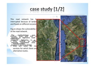
This document presents a new methodology for assessing the vulnerability of road networks using GIS applications. It describes calculating a vulnerability index based on road design characteristics and identifying critical links. The methodology was applied to a road network in Ogliastra, Italy. Maps showed the most vulnerable central links that are on multiple shortest paths and critical for rescue services. Considering population in the exposure index showed more vulnerable municipalities in more populated areas. The methodology effectively evaluates vulnerability in low traffic, low population density areas and can help prioritize road improvements and emergency management.


