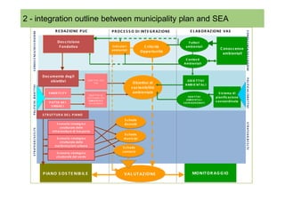
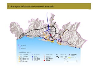
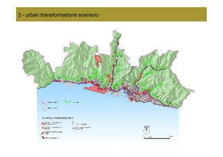
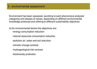
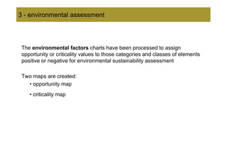
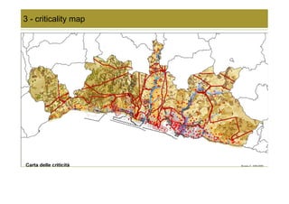
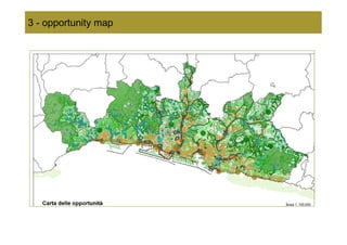
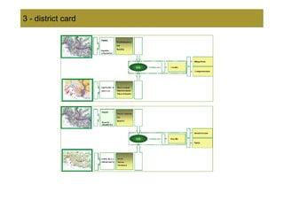
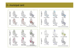
This document discusses the strategic environmental assessment (SEA) conducted for the urban plan of the municipality of Genoa, Italy. It describes the SEA process, which included building environmental knowledge, assessing the plan's impacts, and developing tools like district cards and municipal cards. The goal of the SEA was to integrate environmental considerations into the urban plan to promote sustainability. It analyzed the plan's proposals for transport, urban transformations, and green spaces using geographical information systems. The assessment evaluated impacts on environmental factors and contexts to identify opportunities and critical issues.
Pier Luigi Paolillo, Alberto Benedetti, Giorgio Graj, Luca Terlizzi and Roberto Bisceglie on "The decisions support scenarios in the first phases of the strategic environmental evaluation: the Barzio territory government plan experience"
Gabriele Nolè, Rosa Lasaponara, Maria Danese, Beniamino Murgante and Antonio Lanorte on "Analyzing urban growth with spatial autocorrelation in multi-temporal satellite data"
Pratelli, Petri, Rindone & De Bari - input2012INPUT 2012
Antonio Pratelli, Massimiliano Petri, Corrado Rindone and Francescalberto de Bari on "A feasibility study for new transport connections between Italia and Algeria"
The document discusses spatial (strategic) foresight and modeling styles for geoprospecting. Geoprospecting aims to anticipate medium and long-term futures of territories to inform planning and management decisions. It specifically considers spatial dynamics and interactions by spatializing prospective scenarios. Modeling is seen as an intrinsic part of geoprospecting, with different modeling styles existing along a spectrum from forecasting to designing the future. The link between prospection and models depends on factors like the social reason for application, the modeler's opinions, the model's function and intrinsic characteristics, and how it is designed for a specific case study.
The document discusses the relationship between spatial representations, urban planning, and digitization. It covers topics like urban models and their role in planning, the impact of new digital data and public participation, and how representations are shifting to incorporate virtual environments. Idealized urban models are giving way to more accurate digital representations incorporating data from sensors, satellites, and ubiquitous digital networks. This allows new forms of public participation in planning processes and more accurate analysis of social and physical urban environments.
The document discusses participatory sensing and smart cities. It describes participatory sensing as an approach where individuals use mobile devices to collect and interpret data about their world. This helps people understand reality through data and change habits. The document advocates for creating communities before building projects. It presents DreamHamar as a network design process that engaged the public. It promotes participatory mapping, open networks, and community participation and sharing to build social cohesion in smart cities.
Giuseppe Roccasalva and Antonio Spinelli on "Responsive parametric Infrastructure. From self consciousness to civi(l)c awareness: Turin renewal working in progress"
Giorgio Limonta on "Representation and analysis of retail phenomena to support
urban planning policies.Some applications of the Kernel Density Estimation method in the Milan area."
Piergiuseppe Pontrandolfi and Antonella Cartolano on "Promoting local development through a new representation and interpretation of the context: the Val d’Agri case"
Francesca Bodano, Luisa Ingaramo and Stefania Sabatino on "The Urban Areas Competitiveness Report (RCAU): an information system to support the JESSICA revolving funds in Italy"
1) The document analyzes mobility patterns and preferences among different demographic segments in European cities. It identifies segments that are most receptive to various smart mobility policies.
2) It finds that female 15-24, female 25-39, and male 25-39 segments are most open to single ticketing, easy transfers between modes, and online ticket purchasing. Male 25-39 and male 55+ prefer new road charging schemes.
3) It maps these receptive segments across neighborhoods in Cagliari, Italy and recommends targeted mobility policies for different areas based on their demographic characteristics and densities.
This document proposes a quantitative approach to computing the image of a city. It begins by discussing how the image of a city is traditionally obtained through qualitative interviews. It then introduces concepts like legibility and imageability that contribute to a city's mental image. The core of the proposal is a multi-step process: 1) organizing city artifacts into layers, 2) ranking artifacts by size, 3) partitioning artifacts into "head" and "tail" groups using the mean size as the threshold, and 4) iteratively applying this partitioning until the distribution of large artifacts is no longer heavy-tailed. This process aims to capture the underlying "scaling pattern" common to cities where there are far more small artifacts than large ones. The
Maltinti, Melis and Annunziata - input2012INPUT 2012
This document presents a new methodology for assessing the vulnerability of road networks using GIS applications. It describes calculating a vulnerability index based on road design characteristics and identifying critical links. The methodology was applied to a road network in Ogliastra, Italy. Maps showed the most vulnerable central links that are on multiple shortest paths and critical for rescue services. Considering population in the exposure index showed more vulnerable municipalities in more populated areas. The methodology effectively evaluates vulnerability in low traffic, low population density areas and can help prioritize road improvements and emergency management.
Sandro Fabbro and Marco Dean on "Regional development strategies: the role of infrastructures and transport. The case of the Friuli Venezia Giulia region in the wider Northeastern Italian macroregion"
This document discusses participation and consultation in strategic environmental assessments (SEAs) for land use plans. It analyzes the SEA process for city masterplans in several municipalities in Sardinia, Italy. Key points include:
- The SEA Directive and other agreements emphasize the importance of public participation early in the planning process. However, implementation of participation is inconsistent.
- Guidelines for Sardinian municipalities integrated the SEA process into land use planning, but public participation was limited to identification rather than involvement.
- Case studies showed participation mainly involved authorities, with limited public engagement until late in the planning process, contrary to best practices.
- Early and meaningful public participation is important for integrated decision-making
This document presents a methodology for developing an expert system to assess the environmental sensitivity of energy systems and create sensitivity maps for the Emilia-Romagna region of Italy. The methodology involves identifying types of energy plants, sensitivity themes, interference rules between themes and plants, an interference matrix of themes and plant compatibility, researching and organizing sensitivity theme data, and creating overlay maps to identify environmentally sensitive and preferential areas for siting energy plants. The system is intended to support environmental impact assessments and strategic planning.
This document outlines a formative study on designing effective visualization interfaces for planning support systems. The study evaluated nine interface prototypes for a land use planning system called LEAM over three years. Key principles for effective interfaces were derived based on the evaluations. These principles include using appropriate graphic representations and layouts to direct user attention and maintain engagement. Effective graphic representations use proximity and a limited number of attributes to show relationships between different variables. Effective layouts group related drivers and impacts closely, align scales for comparison, and provide motivation and flexibility.
2. 0 - SEA: methodological paths and functional efficiency for
municipality urban planning
Summary
1 – Characteristics and peculiarity of SEA for Municipal Urban Plans
2 – Environmental knowledge construction, techniques and method
3 – Environmental assessment, tools and procedures
4 – Considerations about technical content and operative effectiveness
3. 1 - general consideration on Urban Plan of Genova Municipality SEA
SOMMARIO
Few axioms founding SEA formulation
A) About urban municipality plan
1 – Municipal Urban Plans draw up a project of a possible world , respectful
of public interest
2 – The project language is hybrid, joining the land use plan with
transformations governing norms
3 –Environmental quality and sustainability are taken into consideration more
frequently among public interest reasons,
4 – SEA introduces in Municipal Urban Plans environmental quality and
sustainability considerations, producing information about the induced effects
of transformations
4. 1 - general consideration on Urban Plan of Genova Municipality SEA
B) About sustainability and environment
5 – Sustainable development concept is not univocal because the paths for
sustainability are different: from those based on technological tools to
those proposing new development models
6 – The meaning of environment is wide and diversified; the path for building
environmental knowledge is not automatic and often is under-estimate
5. 2 SOMMARIO
- environmental knowledge
The environmental knowledge building approach has been followed to
respond two requirements:
1 – to represent data, information and knowledge in geographical pattern, in
order to compare them with transformations drawing for the plan’s land
use
2 – to build different environmental knowledge, referring to different
ontologies and using diversified concept categories (to analyze
geographical territorial objects) and environmental sustainability
meanings (to evaluate territorial transformations forecasted by plan):
a) analytical knowledge of environmental sciences, related to
single environmental factors
b) synthetic knowledge of geographical sciences, referring to
different environmental regions
6. 2 SOMMARIO
- environmental knowledge
In the first case, the following environmental factors have been assumed
for:
a) essential components of natural environment:
atmosphere ( air ), hydrosphere ( water ), lithosphere ( soil ), biosphere
( vegetation )
b) most important anthropic pressure actions on essential components of
natural environment: energetic use, electro-magnetic agents, wastes,
traffic
Moreover areas of significant historic and cultural value have been
considered
Collected data have been represented on environmental factors and historic
and cultural value charts
7. 2 SOMMARIO
- environmental knowledge
In the second case, environmental contexts have been assumed as areas
characterized by peculiar relations between natural environment and human
interventions, describing specific territorial , environmental and landscape
variations.
They are:
Coastal context
Urban context
Rural context
Natural context
The contexts a) have a specific identity (territorial, environmental and
landscape) characterized by a peculiar diversity of the relationship between
natural environment and anthropic interventions, b) represent geographical,
ecological and environmental diversities inside the municipal territory.
8. 2 - outline of relations between environmental factors, territorial
factors and environmental context
COMPONENTI AGENTI
DI PRESSIONE VALORI
AMBIENTALI
contesto marittimo
contesto urbano
costiero
contesto naturale
contesto rurale
DETERMINANTI PRESSIONI VALORI
TERRITORIO URBANIZZATO
9. 2 - environmental knowledge
Integration is a key word for environmental knowledge building
• integration with foundation knowledge of municipality urban plan
• integration to confront with land use plan language
• integration of natural sciences analytical knowledge with geographical and
territorial sciences synthetic knowledge
• integration to get over epistemological differences between urban planning
and environmental sciences about:
– statutes
– paradigms
– parameters
– values
10. 2 SOMMARIO outline between municipality plan and SEA
- integration
R E D AZ IO NE P UC P R O C E S S O DI INT E G R AZ IO NE E L AB O R AZ IO NE VAS
C O NO S C E NZ A/ DE S C R IZ IO NE
Des c rizione F attori
F ondativa Indic atori C ritic ità ambientali
C onos c enz e
ambientali O pportunità
ambientali
C ontes ti
Ambientali
Doc umento deg li
P O L IT IC HE / O B IE T T IVI
obiettivi O B IE T T IV I DE L
O B IE T T IV I DE L O B IE T T IVI
P UC
P UC O biettivi di AMB IE NT AL I
P O L IT IC HE /O B IE T T IVI
s os tenibilità
S MAR T C IT Y ambientale S is tema di
O B IE T T IV I DI
O B IE T T IV I DI
S O S T E NIB IL IT A’
O B IE T T IVI
O B IE T T IVI pianific az ione
S O S T E NIB IL IT A’
AMB IE NT A L I
AMB IE NT A L I
P AT T O DE I
AMB IE NT AL E
AMB IE NT AL E
S O VR AO R DINAT I
s ovraordinata
P er G E NO V A
P er G E NO V A
S IND AC I
S T R UT T UR A DE L P IANO
S c hede
S T R AT E G IE /S C E L T E
S c enario s trateg ic o dis tretti
s trutturale delle
S T R AT E G IE / S C E L T E
infras trutture di tras porto
S c hede
S c enario s trateg ic o munic ipi
s trutturale delle
tras formazioni urbane
S c hede
S c enario s trateg ic o c ontes ti
s trutturale del verde
P IANO S OS T E NIB IL E VAL UT AZ IONE MONIT O R AG G IO
11. 3 - environmental assessment
In the SEA procedure, only documents with operative and project
effectiveness have been considered and confronted with environmental
knowledge:
•normative documents
•maps of transformations project forecasted by plan, reorganized according
to three thematic scenarios:
- the transport infrastructures network scenario
- the urban transformations scenario
- the green areas scenario
15. 3 - environmental assessment
Environment has been assessed, ascribing to each phenomena analyzed
categories and classes of values, depending on different environmental
knowledge produced and refering to different sustainability objectives
A) for environmental factors the objectives are:
•energy consumption reduction
•natural resources consumption reduction
•pollution air, water and soil reduction
•climatic change contrast
•hydrogeological risk contrast
•biodiversity protection
16. 3 - environmental assessment
The environmental factors charts have been processed to assign
opportunity or criticality values to those categories and classes of elements
positive or negative for environmental sustainability assessment
Two maps are created:
• opportunity map
• criticality map
19. 3 - environmental assessment
B) for environmental contexts the objectives are to propose a new
alliance between "country" and "town" into the river basin eco-system to:
closing vital cycles of urban metabolism
controlling the cumulative effects of transformations projects
forecasted by plan
The contexts chart has been processed with the river basins and local
municipalities maps to obtain
the valleys sections chart
− the civic unity chart
21. 3 - environmental assessment
For SEA procedure the GIS has been a fundamental tool:
•to collect environmental knowledge, plan knowledge, structures and
projects
•to confront their geographical and spatial configuration
•to analyze their topological relations
•to monitor their evolution
Using the GIS two fundamental assessment tools have been produced
•The district card, to assess each area where the strategic
transformations are forecasted by plan
•The municipal card, to assess the comprehensive development project
of each local municipality, resulting from all the transformations there
forecasted by plan
24. 4 - conclusions
A) considerations on technical contents
•geographical and procedural tools have been produced to know and
assess the environmental effects of transformations forecasted by plan
•complex knowledge has been produced and represented in a synthetic
way, using a lot of data arising from different sources
•cognitive and assessment models have been utilized, referring to formal
ontologies that facilitate the transparency of evaluation process
•many actors having environmental roles and competence have been
involved
•models and procedures, implemented on the GIS, can be used
independently from actual municipality plan structure and can be used for
monitoring its changing
25. 4 - conclusions
B) considerations on effectiveness and utility
•The SEA procedure, without normative measures, risks to become a
rhetoric exercise
•The environmental improvement, started with the SEA procedure, should
truly involve citizens, not only formally
•Political engagement cannot be disregarded, if the SEA necessity and
utility are not recognized, its effectiveness is null and void