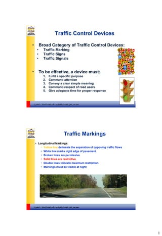
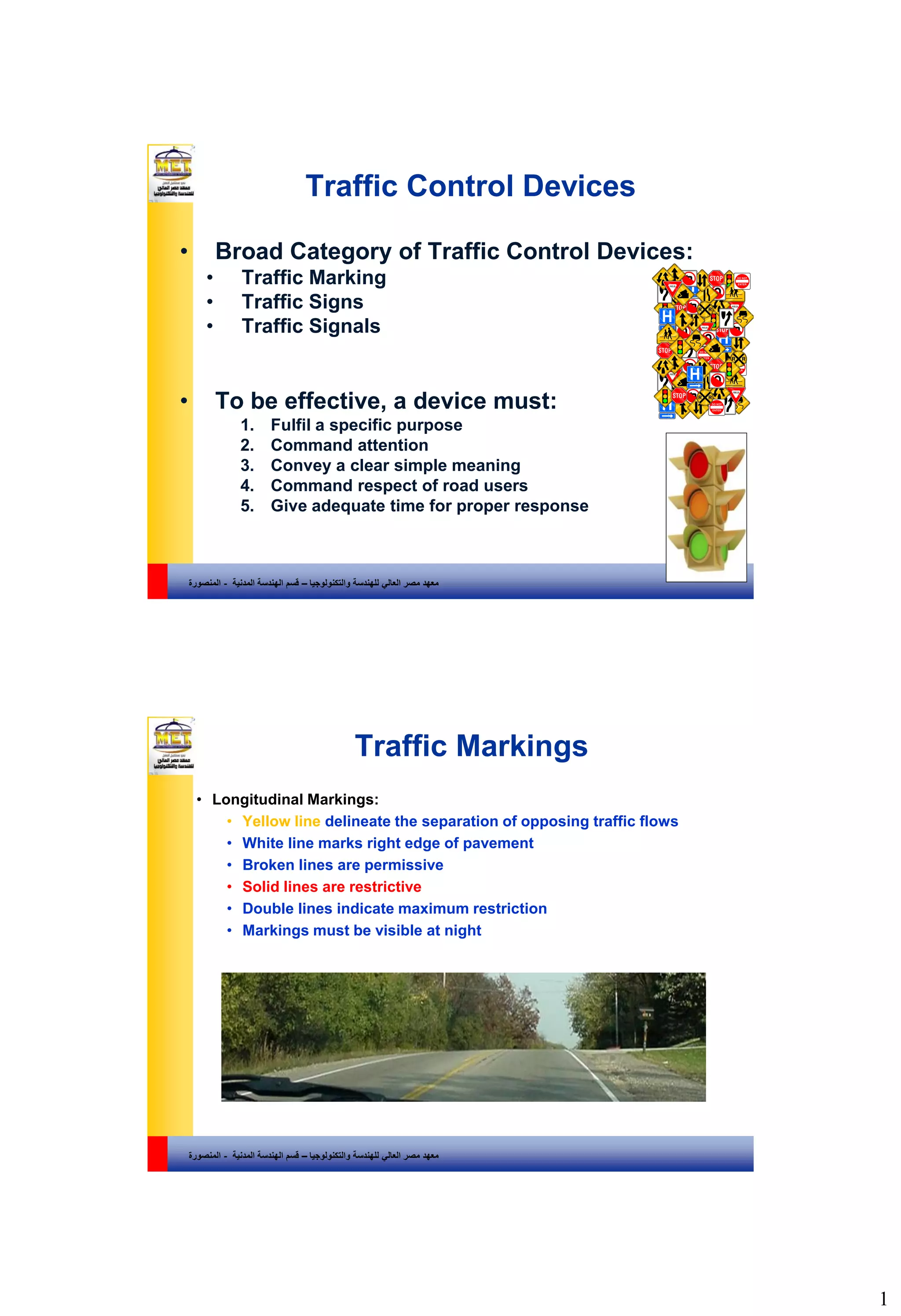
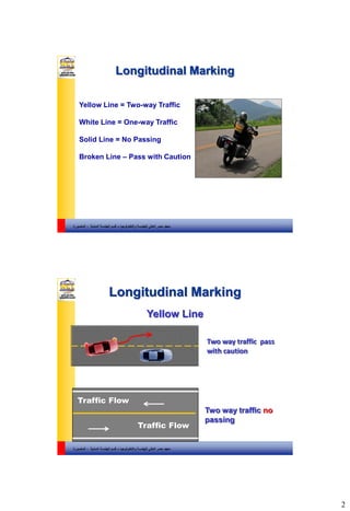
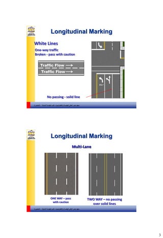
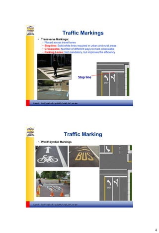
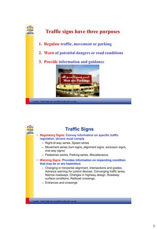
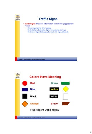
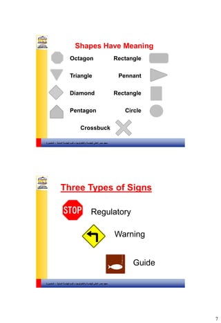
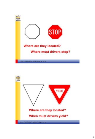
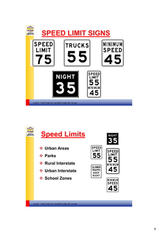
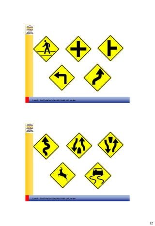
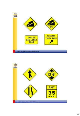
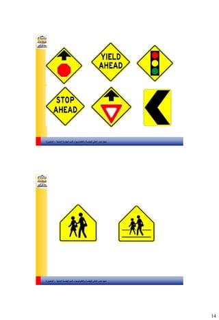
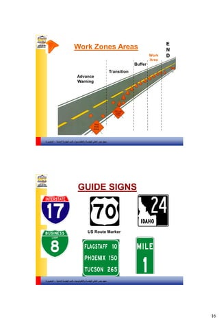
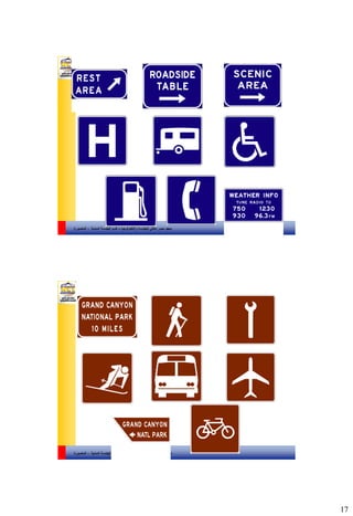
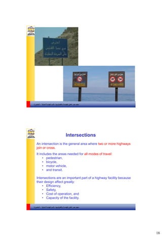
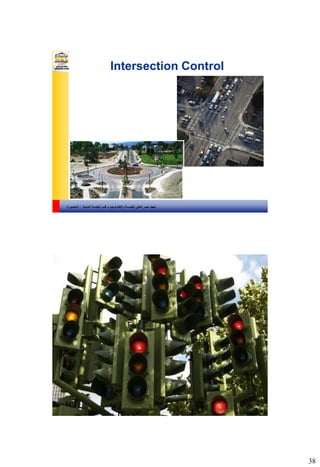
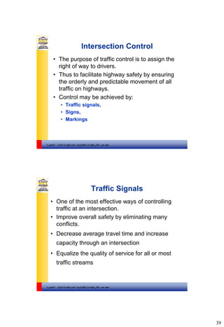
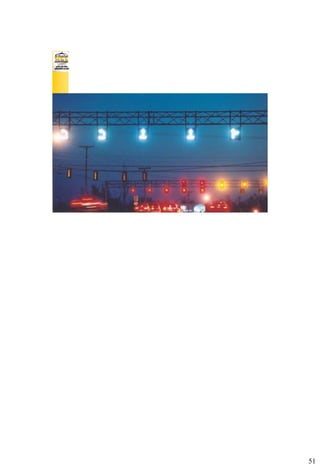
The document discusses different types of traffic control devices used to regulate vehicle and pedestrian traffic. It describes traffic markings like longitudinal lines that delineate lanes and indicate whether passing is allowed. It also covers traffic signs that regulate movements, warn of hazards, and provide guidance to drivers. Common shapes and colors for signs are outlined. Finally, it discusses traffic signals and their role in controlling intersections.
Capacity & Level of Service: Highways & Signalized Intersections (Indo-HCM)Vijai Krishnan V
This presentation gives a glimpse on estimating the capacity and Level of Service (LOS) of highway midblock sections and signalized intersections under heterogeneous traffic conditions using the Indo-HCM 2017 Manual. It also compares the Indo-HCM LOS estimation methods with US-HCM. Some practice questions are also included.
I acknowledge the co-author Ms. Sethulakshmi G (Ph. D. Scholar, NIT Surathkal) for her valuable contribution to this presentation.
Detailed description of Capacity and Level of service of Multi lane highways based on Highway Capacity Manual (HCM2010) along with one example for finding LOS of a highway
Origin and Destination ( O-D) Study. defined all types very well with advantages and disadvantages. Introduction of OD, Objective of OD Study
Information required for OD
OD Survey Types
Methodology
Road Side Interview Method
License Plate Method
Tag on Car method
Home Interview method
postal method
online survey method
commercial and public vehilce method survey
OD MATRIX
Desire line diagram and Flow Line diagram
Conclusion and Reference.
intersection are the space in which more than 2 roads crosses.types of road intersection,grade separated and at grade separated intersection.
intersection road
intersection tv series
the intersection grand rapids events
point of intersection calculator
intersection movie
intersection 1994
intersection season 4 on netflix
intersection grand rapids
at grade intersection, channelized intersection, diamond intersection, different types of road intersection, directional intersection, grade separated intersection, otary intersection, partial coverleaf intersection, road intersection definition, road intersection diagrams, roadway intersection types, trumpet intersection, un channelized intersection
at-grade junction where two or more roads or streets meet or cross.
THIS AREA IS DESIGNATED FOR THE VEHICLES TO TURN TO Different Direction.
VEHICLES MOVING IN DIFFERENT DIRECTION WANT TO OCCUPY SAME SPACE AT SAME TIME.
This presentation deals with all the major steps involved in the survey, selection of the most possible route and the designing of the highway.
It will brief u on all the major topics of highway designing
Conen 442 module1c: Capacity analysis and Level of ServiceWael ElDessouki
This module focuses on Capacity concepts and the Level of Service for transportation facilities. LOS analysis will be discussed for the multilane highway facility.
Establishment of any new development generates additional trips that may have negative effects on the existing traffic network. To assess the impact of the development traffic on the transport network and to identify reasonable solutions Traffic Impact Assessment (TIA) is performed. In the absence of sophisticated travel demand model TIA is carried out manually. In manual process, total trip generated from the development site is estimated by multiplying the trip rate with the development size. In this process the task can be completed very easily, but the accuracy of the calculation depends on the reliability of the trip rates used in the calculation. As Bangladesh does not have standard trip rates, TIA is generally performed by using trip rates obtained from the Institute of Transportation Engineers’ “Trip Generation” report, which is ideal for Western countries. In this research, trip rates of shopping centers in Dhaka city are estimated.This study conducts only for trip attraction rates of shopping centers having different sizes and located at different places (Dhanmondi, Gulshan and Siddheswari) in Dhaka city. In order to do so number of persons and vehicles entering the shopping centers in every fifteen minutes interval during peak periods are counted then converted for an hour. From the survey data, it is found that the trip attraction rates of small shopping centers are much higher than that of medium size shopping centers. Macroscopic model is also developed from the survey data. The macroscopic modelrelates the attraction rates of the shopping centers as a function of the physical features such as gross floor area, number of car parking, number of shops and availability of restaurants(available or not) in the shopping centers.
Uncover the Technology behind Indian RailwaysNikita Khanna
Indian railways is the world’s fourth largest railway networks comprising of 7,172 stations, 65,436 km of route and track length of 1,15,000 kilometers.
Safety in construction stage (by Md Abdur Rahman)Md Abdur Rahman
The slideshow presents the current scenario of Ashram Chawk where a underpass is under construction and safety features are not proposed as per guidelines.
Intelligent Transportation Systems (ITS) is the application of computer, electronics, and communication technologies and management strategies in an integrated manner to provide traveller information to increase the safety and efficiency of the surface transportation systems.
These systems involve vehicles, drivers, passengers, road operators, and managers all interacting with each other and the environment, and linking with the complex infrastructure systems to improve the safety and capacity of road systems.
ITS is an emerging transportation system which is comprised of an advanced information and Telecommunications network for users, roads and vehicles.
A brief explanation about the importance of runway lighting and different types of runway lighting such as Approach Lighting, PAPi, APAPI, VASI, Runway edge, centre, end lighting
Industrial Training at Shahjalal Fertilizer Company Limited (SFCL)MdTanvirMahtab2
This presentation is about the working procedure of Shahjalal Fertilizer Company Limited (SFCL). A Govt. owned Company of Bangladesh Chemical Industries Corporation under Ministry of Industries.
Cosmetic shop management system project report.pdfKamal Acharya
Buying new cosmetic products is difficult. It can even be scary for those who have sensitive skin and are prone to skin trouble. The information needed to alleviate this problem is on the back of each product, but it's thought to interpret those ingredient lists unless you have a background in chemistry.
Instead of buying and hoping for the best, we can use data science to help us predict which products may be good fits for us. It includes various function programs to do the above mentioned tasks.
Data file handling has been effectively used in the program.
The automated cosmetic shop management system should deal with the automation of general workflow and administration process of the shop. The main processes of the system focus on customer's request where the system is able to search the most appropriate products and deliver it to the customers. It should help the employees to quickly identify the list of cosmetic product that have reached the minimum quantity and also keep a track of expired date for each cosmetic product. It should help the employees to find the rack number in which the product is placed.It is also Faster and more efficient way.
Final project report on grocery store management system..pdfKamal Acharya
In today’s fast-changing business environment, it’s extremely important to be able to respond to client needs in the most effective and timely manner. If your customers wish to see your business online and have instant access to your products or services.
Online Grocery Store is an e-commerce website, which retails various grocery products. This project allows viewing various products available enables registered users to purchase desired products instantly using Paytm, UPI payment processor (Instant Pay) and also can place order by using Cash on Delivery (Pay Later) option. This project provides an easy access to Administrators and Managers to view orders placed using Pay Later and Instant Pay options.
In order to develop an e-commerce website, a number of Technologies must be studied and understood. These include multi-tiered architecture, server and client-side scripting techniques, implementation technologies, programming language (such as PHP, HTML, CSS, JavaScript) and MySQL relational databases. This is a project with the objective to develop a basic website where a consumer is provided with a shopping cart website and also to know about the technologies used to develop such a website.
This document will discuss each of the underlying technologies to create and implement an e- commerce website.
Water scarcity is the lack of fresh water resources to meet the standard water demand. There are two type of water scarcity. One is physical. The other is economic water scarcity.
About
Indigenized remote control interface card suitable for MAFI system CCR equipment. Compatible for IDM8000 CCR. Backplane mounted serial and TCP/Ethernet communication module for CCR remote access. IDM 8000 CCR remote control on serial and TCP protocol.
• Remote control: Parallel or serial interface.
• Compatible with MAFI CCR system.
• Compatible with IDM8000 CCR.
• Compatible with Backplane mount serial communication.
• Compatible with commercial and Defence aviation CCR system.
• Remote control system for accessing CCR and allied system over serial or TCP.
• Indigenized local Support/presence in India.
• Easy in configuration using DIP switches.
Technical Specifications
Indigenized remote control interface card suitable for MAFI system CCR equipment. Compatible for IDM8000 CCR. Backplane mounted serial and TCP/Ethernet communication module for CCR remote access. IDM 8000 CCR remote control on serial and TCP protocol.
Key Features
Indigenized remote control interface card suitable for MAFI system CCR equipment. Compatible for IDM8000 CCR. Backplane mounted serial and TCP/Ethernet communication module for CCR remote access. IDM 8000 CCR remote control on serial and TCP protocol.
• Remote control: Parallel or serial interface
• Compatible with MAFI CCR system
• Copatiable with IDM8000 CCR
• Compatible with Backplane mount serial communication.
• Compatible with commercial and Defence aviation CCR system.
• Remote control system for accessing CCR and allied system over serial or TCP.
• Indigenized local Support/presence in India.
Application
• Remote control: Parallel or serial interface.
• Compatible with MAFI CCR system.
• Compatible with IDM8000 CCR.
• Compatible with Backplane mount serial communication.
• Compatible with commercial and Defence aviation CCR system.
• Remote control system for accessing CCR and allied system over serial or TCP.
• Indigenized local Support/presence in India.
• Easy in configuration using DIP switches.
Student information management system project report ii.pdfKamal Acharya
Our project explains about the student management. This project mainly explains the various actions related to student details. This project shows some ease in adding, editing and deleting the student details. It also provides a less time consuming process for viewing, adding, editing and deleting the marks of the students.
Hierarchical Digital Twin of a Naval Power SystemKerry Sado
A hierarchical digital twin of a Naval DC power system has been developed and experimentally verified. Similar to other state-of-the-art digital twins, this technology creates a digital replica of the physical system executed in real-time or faster, which can modify hardware controls. However, its advantage stems from distributing computational efforts by utilizing a hierarchical structure composed of lower-level digital twin blocks and a higher-level system digital twin. Each digital twin block is associated with a physical subsystem of the hardware and communicates with a singular system digital twin, which creates a system-level response. By extracting information from each level of the hierarchy, power system controls of the hardware were reconfigured autonomously. This hierarchical digital twin development offers several advantages over other digital twins, particularly in the field of naval power systems. The hierarchical structure allows for greater computational efficiency and scalability while the ability to autonomously reconfigure hardware controls offers increased flexibility and responsiveness. The hierarchical decomposition and models utilized were well aligned with the physical twin, as indicated by the maximum deviations between the developed digital twin hierarchy and the hardware.
10-Intersection Control ( Transportation and Traffic Engineering Dr. Sheriff El-Badawy )
1. 1
والتكنولوجيا للهندسة العالي مصر معهد–المدنية الهندسة قسم-المنصورة
Traffic Control Devices
• Broad Category of Traffic Control Devices:
• Traffic Marking
• Traffic Signs
• Traffic Signals
• To be effective, a device must:
1. Fulfil a specific purpose
2. Command attention
3. Convey a clear simple meaning
4. Command respect of road users
5. Give adequate time for proper response
والتكنولوجيا للهندسة العالي مصر معهد–المدنية الهندسة قسم-المنصورة
Traffic Markings
• Longitudinal Markings:
• Yellow line delineate the separation of opposing traffic flows
• White line marks right edge of pavement
• Broken lines are permissive
• Solid lines are restrictive
• Double lines indicate maximum restriction
• Markings must be visible at night
2. 2
والتكنولوجيا للهندسة العالي مصر معهد–المدنية الهندسة قسم-المنصورة
Longitudinal Marking
3
Yellow Line = Two-way Traffic
White Line = One-way Traffic
Solid Line = No Passing
Broken Line – Pass with Caution
والتكنولوجيا للهندسة العالي مصر معهد–المدنية الهندسة قسم-المنصورة
Traffic Flow
Traffic Flow
Two way traffic no
passing
Two way traffic pass
with caution
Yellow Line
Longitudinal Marking
4
3. 3
والتكنولوجيا للهندسة العالي مصر معهد–المدنية الهندسة قسم-المنصورة
Traffic Flow
Traffic Flow
White Lines
No passing - solid line
One-way traffic
Broken - pass with caution
Longitudinal Marking
5
والتكنولوجيا للهندسة العالي مصر معهد–المدنية الهندسة قسم-المنصورة
ONE WAY – pass
with caution
TWO WAY – no passing
over solid lines
Longitudinal Marking
6
Multi-Lane
4. 4
والتكنولوجيا للهندسة العالي مصر معهد–المدنية الهندسة قسم-المنصورة
Traffic Markings
• Transverse Markings:
• Placed across travel lanes
• Stop line: Solid white lines required in urban and rural areas
• Crosswalks: Number of different ways to mark crosswalks
• Parking Lanes: Not mandatory, but improves the efficiency
Stop line
والتكنولوجيا للهندسة العالي مصر معهد–المدنية الهندسة قسم-المنصورة
Traffic Marking
• Word/ Symbol Markings
5. 5
والتكنولوجيا للهندسة العالي مصر معهد–المدنية الهندسة قسم-المنصورة
1. Regulate traffic, movement or parking
2. Warn of potential dangers or road conditions
3. Provide information and guidance
Traffic signs have three purposes
والتكنولوجيا للهندسة العالي مصر معهد–المدنية الهندسة قسم-المنصورة
Traffic Signs
• Regulatory Signs: Convey information on specific traffic
regulation, drivers must comply
– Right-of-way series, Speed series
– Movement series (turn signs, alignment signs, exclusion signs,
one-way signs)
– Pedestrian series, Parking series, Miscellaneous
• Warning Signs: Provides information on impending condition
that may be or are hazardous
– Changing in horizontal alignment, Intersections and grades,
Advance warning for control devices, Converging traffic lanes,
Narrow roadways, Changes in highway design, Roadway
surface conditions, Railroad crossings,
– Entrances and crossings
6. 6
والتكنولوجيا للهندسة العالي مصر معهد–المدنية الهندسة قسم-المنصورة
Traffic Signs
• Guide Signs: Provides information on selecting appropriate
routes
• Utmost important for driver’s safety
• Route Markers, Destination Signs: Conventional roadways,
• Destination Signs: Motorways, Service Guide signs, Mileposts
والتكنولوجيا للهندسة العالي مصر معهد–المدنية الهندسة قسم-المنصورة
Colors Have Meaning
Red Green
Blue Yellow
Black White
Orange Brown
Fluorescent Optic Yellow
7. 7
والتكنولوجيا للهندسة العالي مصر معهد–المدنية الهندسة قسم-المنصورة
Shapes Have Meaning
Octagon Rectangle
Triangle
Diamond
Pentagon
Pennant
Rectangle
Circle
Crossbuck
والتكنولوجيا للهندسة العالي مصر معهد–المدنية الهندسة قسم-المنصورة
Three Types of Signs
Regulatory
Warning
Guide
8. 8
والتكنولوجيا للهندسة العالي مصر معهد–المدنية الهندسة قسم-المنصورة
Where must drivers stop?
Where are they located?
والتكنولوجيا للهندسة العالي مصر معهد–المدنية الهندسة قسم-المنصورة
When must drivers yield?
Where are they located?
9. 9
والتكنولوجيا للهندسة العالي مصر معهد–المدنية الهندسة قسم-المنصورة
SPEED LIMIT SIGNS
والتكنولوجيا للهندسة العالي مصر معهد–المدنية الهندسة قسم-المنصورة
Speed Limits
Urban Areas
Parks
Rural Interstate
Urban Interstate
School Zones
10. 10
والتكنولوجيا للهندسة العالي مصر معهد–المدنية الهندسة قسم-المنصورة
RR sign or RR painted
on the pavement are
advanced warning
signs.
Crossbucks are yield signs.
The train has the right-of-way!
Railroad Crossing Warnings
Flashing red lights
Bells
Gates
If you hear or see a train
والتكنولوجيا للهندسة العالي مصر معهد–المدنية الهندسة قسم-المنصورة
Other Regulatory Signs
15. 15
والتكنولوجيا للهندسة العالي مصر معهد–المدنية الهندسة قسم-المنصورة
ORANGE is for Construction
REMEMBER
Common Sense
Caution
Concentration
والتكنولوجيا للهندسة العالي مصر معهد–المدنية الهندسة قسم-المنصورة
Markings Indicating Drivers are
Entering a Work Zone
16. 16
والتكنولوجيا للهندسة العالي مصر معهد–المدنية الهندسة قسم-المنصورة
Work Zones Areas
Advance
Warning
Transition
Buffer
Work
Area
E
N
D
والتكنولوجيا للهندسة العالي مصر معهد–المدنية الهندسة قسم-المنصورة
GUIDE SIGNS
US Route Marker
18. 18
والتكنولوجيا للهندسة العالي مصر معهد–المدنية الهندسة قسم-المنصورة
Intersections
An intersection is the general area where two or more highways
join or cross.
It includes the areas needed for all modes of travel:
• pedestrian,
• bicycle,
• motor vehicle,
• and transit.
Intersections are an important part of a highway facility because
their design affect greatly:
• Efficiency,
• Safety,
• Cost of operation, and
• Capacity of the facility.
19. 19
والتكنولوجيا للهندسة العالي مصر معهد–المدنية الهندسة قسم-المنصورة
Intersection Types
Grade separated
At-grade
With ramps
(Interchanges)
Without ramps
(meaning no
connection
between the
intersection
roads!)
والتكنولوجيا للهندسة العالي مصر معهد–المدنية الهندسة قسم-المنصورة
At-Grade Intersection
Source: FHWA Flexibility in Highway Design
22. 22
والتكنولوجيا للهندسة العالي مصر معهد–المدنية الهندسة قسم-المنصورة
Intersection Types
Basic intersections are
• Three-leg (or T),
• Four leg, and
• Multi-leg intersections.
والتكنولوجيا للهندسة العالي مصر معهد–المدنية الهندسة قسم-المنصورة
Three-Leg Intersections
• The angle of intersection is formed by the intersecting
streets centerlines.
• The best angle is between 75 and 105 degrees.
23. 23
والتكنولوجيا للهندسة العالي مصر معهد–المدنية الهندسة قسم-المنصورة
Four-Leg Intersections
• The angle of intersection is formed by the intersecting
streets centerlines.
• The best angle is between 75 and 105 degrees.
والتكنولوجيا للهندسة العالي مصر معهد–المدنية الهندسة قسم-المنصورة
Multi-Leg Intersections
24. 24
والتكنولوجيا للهندسة العالي مصر معهد–المدنية الهندسة قسم-المنصورة
Basic Types of Movements within
Intersections
• Crossing
• Merging
• Diverging
• Weaving
والتكنولوجيا للهندسة العالي مصر معهد–المدنية الهندسة قسم-المنصورة
Crossing
• Direct Crossings: angle of skew 75 to 105 degrees,
• Oblique Crossing: angle of skew below 75 or above
105 degrees.
• Oblique skews should be voided if at all possible.
25. 25
والتكنولوجيا للهندسة العالي مصر معهد–المدنية الهندسة قسم-المنصورة
Merging
(Joining Traffic Stream)
Diverging
(Separating from Traffic Stream)
والتكنولوجيا للهندسة العالي مصر معهد–المدنية الهندسة قسم-المنصورة
Weaving
Weaving is the combined movement of both merging and
diverging movements in the same direction.
26. 26
والتكنولوجيا للهندسة العالي مصر معهد–المدنية الهندسة قسم-المنصورة
Conflict Points at 4-Leg Intersections
والتكنولوجيا للهندسة العالي مصر معهد–المدنية الهندسة قسم-المنصورة
Conflict Points at T Intersection
29. 29
والتكنولوجيا للهندسة العالي مصر معهد–المدنية الهندسة قسم-المنصورة
Intersections
• Intersections are a key feature of street design in four respects:
• Focus of activity - The land near intersections often contains a
concentration of travel destinations.
• Conflicting movements - Pedestrian crossings, vehicle and
bicycle turning and crossing movements are typically concentrated
at intersections.
• Traffic control - At intersections, movement of users is assigned by
traffic control devices such as yield signs, stop signs, and traffic
signals. For this intersections are often major cause of delay, but
helps to organize traffic and reduce the potential for conflicts.
• Capacity - In many cases, traffic control at intersections limits the
capacity of the intersecting roadways which is defined as the
number of vehicles that can be accommodated within a given period
of time.
30. 30
والتكنولوجيا للهندسة العالي مصر معهد–المدنية الهندسة قسم-المنصورة
Intersection: Key Elements
والتكنولوجيا للهندسة العالي مصر معهد–المدنية الهندسة قسم-المنصورة
Key Elements (1)
• The major street is typically the intersecting street with greater traffic
volume, larger cross-section, and higher functional class. The minor
street is the intersecting street likely to have less traffic volume,
smaller cross-section and lower functional classification than the
major street.
• Intersection legs are those segments of roadway adjacent to the
intersection. The leg used by traffic approaching the intersection is the
approach leg, and that used by traffic leaving is the departure leg.
• Sidewalks, crosswalks and pedestrian curb cut ramps are
considered to be within the intersection. The pavement corner is the
curve connecting the edges of pavement of the intersecting streets.
• The angle of intersection is formed by the intersecting streets’
centrelines. If the angle departs significantly from right angles, the
intersection is called skewed intersection
• Auxiliary lanes are lanes added at the intersection, usually to
accommodate turning motor vehicles. They may also be used to add through
lanes through an intersection.
31. 31
والتكنولوجيا للهندسة العالي مصر معهد–المدنية الهندسة قسم-المنصورة
Key Elements (2)
• Channelizing and divisional islands may be added to an intersection
to help delineate the area in which vehicles can operate, and to
separate conflicting movements. Islands can also provide for
pedestrian refuge.
• A turning roadway is a short segment of roadway for a right turn,
delineated by channelizing islands. Turning roadways are used where
right-turn volumes are very high, or where skewed intersections would
otherwise create a very large pavement area.
• Traffic control devices assign right of way, to both motorized and
non-motorized traffic and include traffic signals, pavement markings,
STOP signs, YIELD signs, pedestrian signal heads and other devices
•
والتكنولوجيا للهندسة العالي مصر معهد–المدنية الهندسة قسم-المنصورة
Intersections
The functional area of an
intersection includes any
auxiliary lanes and their
associated channelization.
32. 32
والتكنولوجيا للهندسة العالي مصر معهد–المدنية الهندسة قسم-المنصورة
Elements of the Functional Area of an Intersection
The functional area on the approach to an intersection or
driveway consists of three basic elements:
(1) Perception-reaction distance,
(2) Maneuver distance, and
(3) Queue-storage distance.
Functional of Impact Length
Maneuver Distance
Decision
Distance
Stopping Queue
or Storage
length
Begin
Deceleration
Begin
Perception Reaction
Deceleration
Completed
والتكنولوجيا للهندسة العالي مصر معهد–المدنية الهندسة قسم-المنصورة
At-Grade Intersection Design
Objectives and Considerations
Need to meet two conflicting objectives:
Minimize the severity of potential conflicts among different
streams of traffic and between pedestrians and turning vehicles.
Provide for the smooth flow of traffic across the intersection
Operating
characteristics of
both the vehicles
and pedestrians
Adequate pavement
width and approach
sight distances must be
provided.
33. 33
والتكنولوجيا للهندسة العالي مصر معهد–المدنية الهندسة قسم-المنصورة
BASIC DESIGN PRINCPLES
والتكنولوجيا للهندسة العالي مصر معهد–المدنية الهندسة قسم-المنصورة
T - Intersections
• Suitable for minor or local roads.
• May be used when minor roads
intersect important highways with
an intersection angle less than 30
degrees from the normal.
• Also suitable for use in rural two-
lane highways that carry light
traffic.
• At locations with higher speeds
and turning volumes, which
increase the potential of rear-end
collisions between through
vehicles and turning vehicles.
• Usually an additional area of
surfacing or flaring is provided.
34. 34
والتكنولوجيا للهندسة العالي مصر معهد–المدنية الهندسة قسم-المنصورة
T - Intersections
Provide auxiliary lane:
in cases where left-turn
volume from a through
road onto a minor road
is sufficiently high but
does not require a
separate left-turn lane.
Auxiliary
Lane
• Channelized T intersection
in which the two-lane
through road has been
converted into a divided
highway through the
intersection.
• Intersection of this type
probably will be signalized.
والتكنولوجيا للهندسة العالي مصر معهد–المدنية الهندسة قسم-المنصورة
Channelization: Objectives
• Direct the paths of
vehicles
• Control the merging,
diverging, and crossing
angle of vehicles
• Reduce the amount of
paved area
• Provide a clear indication
of the proper path for
different movements
• Give priority to the
predominant movements
• Provide pedestrian refuge
• Provide separate storage
lanes for turning vehicles
• Provide space for traffic
control devices for
visibility
• Control prohibited turns
• Separate different traffic
movements at signalized
intersections with multiple-
phase signals
• Restrict the speeds of
vehicles
35. 35
والتكنولوجيا للهندسة العالي مصر معهد–المدنية الهندسة قسم-المنصورة
4-Leg Intersections
• Mainly used at locations
where minor or local roads
cross.
• it also can be used where a
minor road crosses a major
highway.
• In these cases, the turning
volumes are usually low and
the roads intersect at an
angle that is not greater
than 30 degrees from the
normal.
Simple Unchannelized Intersection
والتكنولوجيا للهندسة العالي مصر معهد–المدنية الهندسة قسم-المنصورة
4-Leg Intersections
• Right-turning roadways are
provided when right-turning
movements are frequent.
• Also common where
pedestrians are present.
Right
Turning
Roadways
36. 36
والتكنولوجيا للهندسة العالي مصر معهد–المدنية الهندسة قسم-المنصورة
4-Leg Intersections
Suitable for:
• A two lane highway
• Not a minor crossroad.
• Carries moderate volumes at high speeds
• or operates near capacity.
والتكنولوجيا للهندسة العالي مصر معهد–المدنية الهندسة قسم-المنصورة
4-Leg Intersections (Channelized)
Suitable for:
• Four lane approaches
• Carrying high through volumes and high turning volumes.
• Usually signalized
37. 37
والتكنولوجيا للهندسة العالي مصر معهد–المدنية الهندسة قسم-المنصورة
Multi-Leg Intersections
• Multi-leg intersections have five or more approaches.
• Whenever possible, this type of intersection should be avoided.
والتكنولوجيا للهندسة العالي مصر معهد–المدنية الهندسة قسم-المنصورة
Multi-Leg Intersections
In order to remove some of the conflicting movements and increase
safety and operation one or more of the legs are realigned.
Note: the distances between the aligned
intersections should be great enough to
allow for the independent operation of
each intersection.
39. 39
والتكنولوجيا للهندسة العالي مصر معهد–المدنية الهندسة قسم-المنصورة
Intersection Control
• The purpose of traffic control is to assign the
right of way to drivers.
• Thus to facilitate highway safety by ensuring
the orderly and predictable movement of all
traffic on highways.
• Control may be achieved by:
• Traffic signals,
• Signs,
• Markings
والتكنولوجيا للهندسة العالي مصر معهد–المدنية الهندسة قسم-المنصورة
Traffic Signals
• One of the most effective ways of controlling
traffic at an intersection.
• Improve overall safety by eliminating many
conflicts.
• Decrease average travel time and increase
capacity through an intersection
• Equalize the quality of service for all or most
traffic streams
40. 40
والتكنولوجيا للهندسة العالي مصر معهد–المدنية الهندسة قسم-المنصورة
Traffic Signal
• Separate individual movements in time
rather than in space
والتكنولوجيا للهندسة العالي مصر معهد–المدنية الهندسة قسم-المنصورة
Terminology & Definitions
• Green time: The time period in which the traffic signal has the green
indication
• Red time: The time period in which the traffic signal has the red indication
• Yellow time: The time period in which the traffic signal has the yellow
indication
• Cycle: One complete rotation or sequence of all signal indications
• Cycle time (or cycle length): The total time for the signal to complete
one sequence of signal indication.
41. 41
والتكنولوجيا للهندسة العالي مصر معهد–المدنية الهندسة قسم-المنصورة
• Lost Time: A portion of green or yellow time which is not utilised
by traffic flow movements in a cycle.
• Start-up lost time (l1): At the beginning of each green indication
as the first few cars in a standing queue experience start-up
delays. This delay is measured as start-up lost time.
• The clearance lost time (all-red): It is estimated by the amount
of the yellow time not used by vehicles.
• Phase: That part of a cycle allocated to a stream of traffic or a
combination of two or more streams of traffic having the right-of-
way simultaneously during one or more intervals.
• Effective green time (gi): The effective green time, for a phase,
is the time during which vehicles are actually discharging
through the intersection,
Gi = actual green time, Yi = yellow time, tL = lost times for a phase i.
Terminology (Cont’d)
والتكنولوجيا للهندسة العالي مصر معهد–المدنية الهندسة قسم-المنصورة
Terminology (Cont’d)
• All-red interval. The display time of a red
indication for all approaches.
• It is sometimes used as a phase exclusively
for pedestrian crossing or to allow vehicles
and pedestrians to clear very large
intersections before opposing approaches are
given the green indication.
42. 42
والتكنولوجيا للهندسة العالي مصر معهد–المدنية الهندسة قسم-المنصورة
Two Phase Signal System
والتكنولوجيا للهندسة العالي مصر معهد–المدنية الهندسة قسم-المنصورة
Traffic Signal Times9
0
43. 43
Saturation Flow
Number of vehicles that would pass through
the intersection during an entire hour of green
G
Time (sec)
FlowRate(vphpl)
Y
Saturation
Flow S
Given h, S=?
Effective Green Time
Effective Green G’
G
Time (sec)
FlowRate(vphgpl)
Y
Saturation
Flow
Time during which the flow is assumed to take
place at saturation flow
44. 44
Lost Time
Effective Green G’
G
Time (sec)
FlowRate(vphgpl)
Y
Saturation
Flow
Time during which no flow takes
place
Lost Time
I2
Lost Time
I1
21 llGYG
والتكنولوجيا للهندسة العالي مصر معهد–المدنية الهندسة قسم-المنصورة
Discharge Headways
• Consider N vehicles discharging from the intersection
when a green indication is received.
• The first discharge headway is the time between the
initiation of the green indication and the rear wheels of
the first vehicle to cross over the stop line.
• The Nth discharge headway (N>1) is the time between
the rear wheels of the N-1th and Nth vehicles crossing
over the stop line.
45. 45
والتكنولوجيا للهندسة العالي مصر معهد–المدنية الهندسة قسم-المنصورة
Discharge Headways
• The headway begins to level off with 4 or 5th vehicle.
• The level headway = saturation headway
• Start-up lost time can be expressed as: 1 ( )l e i
والتكنولوجيا للهندسة العالي مصر معهد–المدنية الهندسة قسم-المنصورة
Saturation flow rate
In a given lane, if every vehicle consumes an
average of h seconds of green time, and if the signal
continues to be uninterruptedly green, then S vph
could enter the intersection where S is the
saturation flow rate (vehicles per hour of green time
per lane) given by
3600
S
h
46. 46
والتكنولوجيا للهندسة العالي مصر معهد–المدنية الهندسة قسم-المنصورة
Intersection Capacity
The maximum hourly rate at which persons or vehicles can
be reasonably expected to traverse a point or uniform
segment of a lane or roadway during a given time period
under prevailing traffic and roadway conditions.
(HCM 2000)
•Unlike saturation flow, capacity considers traffic signal
conditions
The formula for calculating capacity (c) is,
c = (g/C) · s · N
Where:
c = capacity (pcu/hour)
g = Effective green time for the phase in question (sec)
C = Cycle length (sec)
N = no. of lanes
s = Saturation flow rate (pcu/hour)
9
7
والتكنولوجيا للهندسة العالي مصر معهد–المدنية الهندسة قسم-المنصورة
Phase Design Steps
• Determination of cycle length (time)
• If tLi is the start-up lost time for a phase i, then the
total start-up lost time per cycle,
• where N is the number of phases.
• If start-up lost time is same for all phases, then the
total start-up lost time for cycle, L = N tL.
• If C is the cycle length in seconds, then the number
of cycles per hour = 3600/C.
• The total lost time per hour = 3600L/C.
• Substituting in L = N tL, then total lost time per hour
will be as follows:
• L =
N
i LtL 1
C
tN L..3600
47. 47
والتكنولوجيا للهندسة العالي مصر معهد–المدنية الهندسة قسم-المنصورة
• The total effective green time Tg equal one hour
minus the total lost time in an hour as follows:
• Tg=
• Critical lane volume that can be accommodated
per hour is given by Vc = Tg/h
• Vc=
• Then, C= i
c
L
s
V
tN
1
.
والتكنولوجيا للهندسة العالي مصر معهد–المدنية الهندسة قسم-المنصورة
Green splitting
• Total effective green time, Tg
• Actual green time , Gi
48. 48
والتكنولوجيا للهندسة العالي مصر معهد–المدنية الهندسة قسم-المنصورة
• Example:
• The phase diagram with flow values of an
intersection with two phases is shown in the
following figure. The lost time and yellow time for
the first phase is 2.5 and 3 seconds,
respectively. For the second phase the lost time
and yellow time are 3.5 and 4 seconds,
respectively. If the cycle time is 120 seconds,
find the green time allocated for the two phases.
والتكنولوجيا للهندسة العالي مصر معهد–المدنية الهندسة قسم-المنصورة
• Answer:
• Critical lane volume for the first phase, Vc1 = 1000
veh/hr.
• For the second phase, Vc2 = 600 veh/hr.
• The sum of the critical lane volumes = 1000+600 =
1600 veh/hr.
• Effective green time can be computed from equation
as
• Tg =120-(2.5-3.5)= 114 seconds.
• Green time for the first phase, g1 and second phase
can be computed from:
• ondsg sec25.71114
1600
1000
1
ondsg sec75.42114
1600
600
2
49. 49
والتكنولوجيا للهندسة العالي مصر معهد–المدنية الهندسة قسم-المنصورة
• Actual green time can be determined from:
• First phase, G1 = 71.25-3+2.5 = 70.75 seconds.
• Second phase, G2 = 42.75-4+3.5 = 42.25
seconds.
• The phase diagram can be drawn in the
following figure.
والتكنولوجيا للهندسة العالي مصر معهد–المدنية الهندسة قسم-المنصورة
Right Turn on Red
• Drivers in all 50 states are allowed to complete
a right turn on red but drivers must
come to a complete stop, yield to any and all
traffic and make sure there is no sign
prohibiting the turn, before completing a right
on red.
50. 50
والتكنولوجيا للهندسة العالي مصر معهد–المدنية الهندسة قسم-المنصورة
Left Turn on Red?
• There is no left turn on red.
والتكنولوجيا للهندسة العالي مصر معهد–المدنية الهندسة قسم-المنصورة
Multi-use Traffic Lanes
• In larger cities, the use of reversible lanes
increases the capacity of the existing streets.
• Center lanes are reversed to allow heavy
traffic, in one direction or the other, to have
more lanes.
• These lanes are marked with a green arrow or
a red X above the lane.