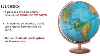
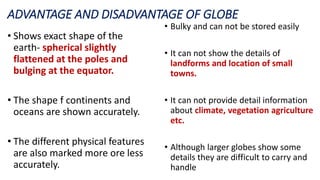
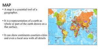
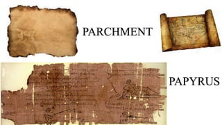
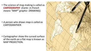
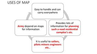
MAPS AND GLOBES
GLOBES
• A globe is a small-scale three
dimensional MODEL OF THE EARTH.
• It is mounted on an axis so that it
can e rotated freely just like an
earth.
• The line of latitude and longitude
are drawn on map.
ADVANTAGE AND DISADVANTAGE OF GLOBE
• Shows exact shape of the
earth- spherical slightly
flattened at the poles and
bulging at the equator.
• The shape f continents and
oceans are shown accurately.
• The different physical features
are also marked more ore less
accurately.
• Bulky and can not be stored easily
• It can not show the details of
landforms and location of small
towns.
• It can not provide detail information
about climate, vegetation agriculture
etc.
• Although larger globes show some
details they are difficult to carry and
handle
MAP
• A map is a essential tool of a
geographer.
• It is a representation of a earth as
whole or part of the earth drawn on a
flat surface.
• It can show continents courtiers cities
and even a local area with all details
• A map how ever has a disadvantages.
• A flat map can not accurately show the
curved surface of the earth.
• When a map is drawn the shape and size
get distorted.
• The maximum distortion occurs in the
region of poles and less at equatorial
region.
• Its not a new phenomenon and has been
practiced since the ancient times.
• They were made from animal skin
parchment papyrus and clay tablets
PAPYRUS
PARCHMENT
• The science of map making is called as
CARTOGRAPHY (Carte- in French
means “MAP” graphic- DRAWING).
• A person who draws map is called as
CARTOGRAPHER.
• Cartographer show the curved surface
of the earth on a flat map is known as
MAP PROJECTION.
TYPESOFMAPS
POLITICAL MAPS
PHYSICAL MAP
TOPOGRAPHICAL MAP
OR CONTOUR MAP
CLIMATIC MP
TOURIST MAP
THEMATIC MAP
POLITICAL MAPS
Shows the boundaries
of administrative units
such as countries,
state and district
Different types of
boundary are shown
with different symbols
PHYSICAL MAP
Shows the landforms and
the water bodies on the
earth surface such as
mountain, plateaus plains,
rivers lakes, sea etc.
Topographical map shows
a great details of both
man made and natural
features with the help of
conventional sins and
symbols
Imaginary line joining
place above the mean
sea level is known as
CONTOUR
All over the world it is
used by geographers,
geologist defense
personal and
surveyors
Climatic map
• Shows weather condition like
temperature, pressure wind
direction and rainfall
Thematic map
• Shows the distribution of
forest, crops, minerals and
vegetation.
USES OF MAP
Easy to handle and can
carry everywhere
Provides lots of
information for planning
such a road residential
complex's etc.
It is useful to sailors,
pilots miners engineers
etc..
Army depend on maps
for information
SKETCH Very often people give
directions to a
particular place by
making a rough drawing
to show the route.
This includes landmarks
and name of the street.
Such diagram is called as
sketch.
Rough map is drawn
without any scale,
conventional sign and
symbol, directions and
distance.
PLAN
DETAILED DRAWING OF A
SMALLAREA
PLAN SHOWS A SMALL
AREA ON A LARGE SCALE
EG- INTERIOR OF HOUSE ,
AN OFFICE BUILDING OR
EVEN YOUR CLASS ROOM
MAP SHOWS A LARGE
AREA ON A SMALL SCALE

Maps and globes

  • 1.
  • 2.
    GLOBES • A globeis a small-scale three dimensional MODEL OF THE EARTH. • It is mounted on an axis so that it can e rotated freely just like an earth. • The line of latitude and longitude are drawn on map.
  • 3.
    ADVANTAGE AND DISADVANTAGEOF GLOBE • Shows exact shape of the earth- spherical slightly flattened at the poles and bulging at the equator. • The shape f continents and oceans are shown accurately. • The different physical features are also marked more ore less accurately. • Bulky and can not be stored easily • It can not show the details of landforms and location of small towns. • It can not provide detail information about climate, vegetation agriculture etc. • Although larger globes show some details they are difficult to carry and handle
  • 4.
    MAP • A mapis a essential tool of a geographer. • It is a representation of a earth as whole or part of the earth drawn on a flat surface. • It can show continents courtiers cities and even a local area with all details
  • 5.
    • A maphow ever has a disadvantages. • A flat map can not accurately show the curved surface of the earth. • When a map is drawn the shape and size get distorted. • The maximum distortion occurs in the region of poles and less at equatorial region. • Its not a new phenomenon and has been practiced since the ancient times. • They were made from animal skin parchment papyrus and clay tablets
  • 6.
  • 7.
    • The scienceof map making is called as CARTOGRAPHY (Carte- in French means “MAP” graphic- DRAWING). • A person who draws map is called as CARTOGRAPHER. • Cartographer show the curved surface of the earth on a flat map is known as MAP PROJECTION.
  • 8.
    TYPESOFMAPS POLITICAL MAPS PHYSICAL MAP TOPOGRAPHICALMAP OR CONTOUR MAP CLIMATIC MP TOURIST MAP THEMATIC MAP
  • 9.
    POLITICAL MAPS Shows theboundaries of administrative units such as countries, state and district Different types of boundary are shown with different symbols
  • 10.
    PHYSICAL MAP Shows thelandforms and the water bodies on the earth surface such as mountain, plateaus plains, rivers lakes, sea etc.
  • 11.
    Topographical map shows agreat details of both man made and natural features with the help of conventional sins and symbols Imaginary line joining place above the mean sea level is known as CONTOUR All over the world it is used by geographers, geologist defense personal and surveyors
  • 12.
    Climatic map • Showsweather condition like temperature, pressure wind direction and rainfall
  • 13.
    Thematic map • Showsthe distribution of forest, crops, minerals and vegetation.
  • 14.
    USES OF MAP Easyto handle and can carry everywhere Provides lots of information for planning such a road residential complex's etc. It is useful to sailors, pilots miners engineers etc.. Army depend on maps for information
  • 15.
    SKETCH Very oftenpeople give directions to a particular place by making a rough drawing to show the route. This includes landmarks and name of the street. Such diagram is called as sketch. Rough map is drawn without any scale, conventional sign and symbol, directions and distance.
  • 17.
    PLAN DETAILED DRAWING OFA SMALLAREA PLAN SHOWS A SMALL AREA ON A LARGE SCALE EG- INTERIOR OF HOUSE , AN OFFICE BUILDING OR EVEN YOUR CLASS ROOM MAP SHOWS A LARGE AREA ON A SMALL SCALE