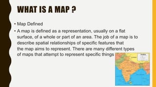
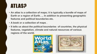
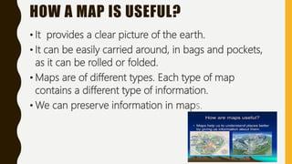
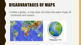
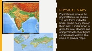
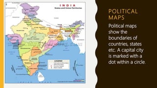
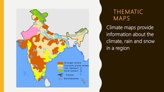
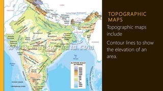
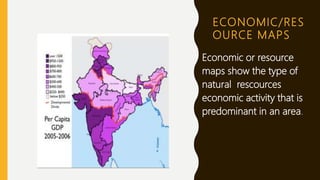
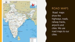
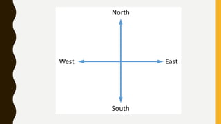
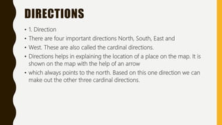
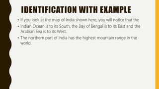
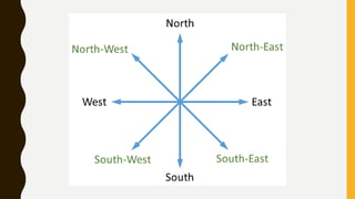
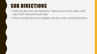
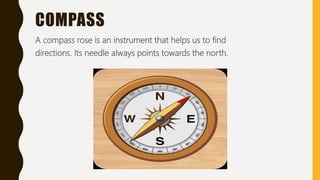
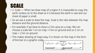
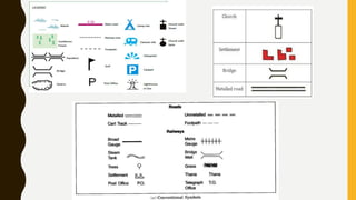
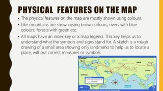
A.R VEENA RAOD . A . V H I G H S C H O O L ( N . S A G A R )
C L A S S - 5
S U B J E C T - S O C I A L S T U D I E S
MAPS
WHAT IS A MAP ?
• Map Defined
• A map is defined as a representation, usually on a flat
surface, of a whole or part of an area. The job of a map is to
describe spatial relationships of specific features that
the map aims to represent. There are many different types
of maps that attempt to represent specific things
WHO IS A CARTOGRAPHER?
• Cartography is making maps. ... Someone who makes maps
is called a cartographer.
• A person who makes maps as a profession is called a
CARTOGRAPHER.
ATLAS?
• An atlas is a collection of maps; it is typically a bundle of maps of
Earth or a region of Earth. ... In addition to presenting geographic
features and political boundaries etc.
• A book or a collection of maps .
• It tells us about the political boundaries of countries, the physical
features, vegetation, climate and natural resources of various
regions of the world.
HOW A MAP IS USEFUL?
• It provides a clear picture of the earth.
• It can be easily carried around, in bags and pockets,
as it can be rolled or folded.
• Maps are of different types. Each type of map
contains a different type of information.
• We can preserve information in maps.
DISADVANTAGES OF MAPS
• Unlike a globe , a map does not show the exact shape of
continents and oceans
PHYSICAL MAPS
Physical maps show us the
physical features of an area.
The land forms and water
bodies can be clearly seen on
these maps. Land is shown in
green for lower elevation and
orange/brownto show higher
elevations and water in blue
colour on physical maps .
POLITICAL
MAPS
Political maps
show the
boundaries of
countries, states
etc. A capital city
is marked with a
dot within a circle.
THEMATIC
MAPS
Climate maps provide
information about the
climate, rain and snow
in a region
TOPOGRAPHIC
MAPS
Topographic maps
include
Contour lines to show
the elevation of an
area.
ECONOMIC/RES
OURCE MAPS
Economic or resource
maps show the type of
natural rescources
economic activity that is
predominant in an area.
ROAD MAPS
Road maps
show the
highways, roads,
railway tracks,
airports and
cities. We use
road maps to our
cities.
READING A MAP
• Reading a Map
• Maps are a storehouse of information.
• But to understand the details of the map, one should know the
essentials of the map.
• These essential are the symbols and signs used on the map to explain
any feature.
DIRECTIONS
• 1. Direction
• There are four important directions North, South, East and
• West. These are also called the cardinal directions.
• Directions helps in explaining the location of a place on the map. It is
shown on the map with the help of an arrow
• which always points to the north. Based on this one direction we can
make out the other three cardinal directions.
IDENTIFICATION WITH EXAMPLE
• If you look at the map of India shown here, you will notice that the
• Indian Ocean is to its South, the Bay of Bengal is to its East and the
Arabian Sea is to its West.
• The northern part of India has the highest mountain range in the
world.
SUB DIRECTIONS
• There are also four sub-directions. These are the north-west, north
east, south-west and south-east.
• These sub-directions lie in between the four main cardinal directions.
COMPASS
A compass rose is an instrument that helps us to find
directions. Its needle always points towards the north.
SCALE
• 2. Scale — When we draw map of a region it is impossible to copy the
earth surface on to the sheet as it is because the earth is vast and our
sheet of paper is small.
• So we use a scale to draw the map. Scale is the ratio between the map
distance and the ground distance.
• For example, if we have to show a 2 km area on a map. We can
choose a scale like 1 cm on map =1 km on ground and so 2 cm on
map = 2 km on ground.
• This makes drawing of maps easy. It is shown on the map in the form
of line bar on a graphic scale.
CONVENTIONAL SYMBOLS
• 3.Conventional Symbols — There are various features on the map
which are shown on map using certain symbols.
• Most of these conventional symbols are very easy to learn and they
make using a map much easier and more clear.
• Following are the example of some of the symbols used on the map:
PHYSICAL FEATURES ON THE MAP
• The physical features on the map are mostly shown using colours.
• Like mountains are shown using brown colours, rivers with blue
colours, forests with green etc.
• All maps have an index key or a map legend. This key helps us to
understand what the symbols and signs stand for. A sketch is a rough
drawing of a small area showing only landmarks to help us to locate a
place, without correct measures or symbols.
POINTS TO REMEMBER
• Points to Remember
• 1. A map is a drawing of the whole Earth or a place on it on a flat piece
of paper.
• 2. A person who makes maps as a profession is called a cartographer.
• 3. A book or a collection of maps is called an atlas.
• 4. Physical maps, political maps, climate maps and thematic maps are
the different
• types of maps.
• 5. Directions, scales, colours, signs and symbols help us to read maps.
THE END

MAPS AND GLOBES PRESENTATION FOR SCHOOL STUDENTS

  • 1.
    A.R VEENA RAOD. A . V H I G H S C H O O L ( N . S A G A R ) C L A S S - 5 S U B J E C T - S O C I A L S T U D I E S
  • 2.
  • 3.
    WHAT IS AMAP ? • Map Defined • A map is defined as a representation, usually on a flat surface, of a whole or part of an area. The job of a map is to describe spatial relationships of specific features that the map aims to represent. There are many different types of maps that attempt to represent specific things
  • 4.
    WHO IS ACARTOGRAPHER? • Cartography is making maps. ... Someone who makes maps is called a cartographer. • A person who makes maps as a profession is called a CARTOGRAPHER.
  • 5.
    ATLAS? • An atlasis a collection of maps; it is typically a bundle of maps of Earth or a region of Earth. ... In addition to presenting geographic features and political boundaries etc. • A book or a collection of maps . • It tells us about the political boundaries of countries, the physical features, vegetation, climate and natural resources of various regions of the world.
  • 6.
    HOW A MAPIS USEFUL? • It provides a clear picture of the earth. • It can be easily carried around, in bags and pockets, as it can be rolled or folded. • Maps are of different types. Each type of map contains a different type of information. • We can preserve information in maps.
  • 7.
    DISADVANTAGES OF MAPS •Unlike a globe , a map does not show the exact shape of continents and oceans
  • 8.
    PHYSICAL MAPS Physical mapsshow us the physical features of an area. The land forms and water bodies can be clearly seen on these maps. Land is shown in green for lower elevation and orange/brownto show higher elevations and water in blue colour on physical maps .
  • 9.
    POLITICAL MAPS Political maps show the boundariesof countries, states etc. A capital city is marked with a dot within a circle.
  • 10.
    THEMATIC MAPS Climate maps provide informationabout the climate, rain and snow in a region
  • 11.
  • 12.
    ECONOMIC/RES OURCE MAPS Economic orresource maps show the type of natural rescources economic activity that is predominant in an area.
  • 13.
    ROAD MAPS Road maps showthe highways, roads, railway tracks, airports and cities. We use road maps to our cities.
  • 14.
    READING A MAP •Reading a Map • Maps are a storehouse of information. • But to understand the details of the map, one should know the essentials of the map. • These essential are the symbols and signs used on the map to explain any feature.
  • 16.
    DIRECTIONS • 1. Direction •There are four important directions North, South, East and • West. These are also called the cardinal directions. • Directions helps in explaining the location of a place on the map. It is shown on the map with the help of an arrow • which always points to the north. Based on this one direction we can make out the other three cardinal directions.
  • 17.
    IDENTIFICATION WITH EXAMPLE •If you look at the map of India shown here, you will notice that the • Indian Ocean is to its South, the Bay of Bengal is to its East and the Arabian Sea is to its West. • The northern part of India has the highest mountain range in the world.
  • 19.
    SUB DIRECTIONS • Thereare also four sub-directions. These are the north-west, north east, south-west and south-east. • These sub-directions lie in between the four main cardinal directions.
  • 20.
    COMPASS A compass roseis an instrument that helps us to find directions. Its needle always points towards the north.
  • 21.
    SCALE • 2. Scale— When we draw map of a region it is impossible to copy the earth surface on to the sheet as it is because the earth is vast and our sheet of paper is small. • So we use a scale to draw the map. Scale is the ratio between the map distance and the ground distance. • For example, if we have to show a 2 km area on a map. We can choose a scale like 1 cm on map =1 km on ground and so 2 cm on map = 2 km on ground. • This makes drawing of maps easy. It is shown on the map in the form of line bar on a graphic scale.
  • 23.
    CONVENTIONAL SYMBOLS • 3.ConventionalSymbols — There are various features on the map which are shown on map using certain symbols. • Most of these conventional symbols are very easy to learn and they make using a map much easier and more clear. • Following are the example of some of the symbols used on the map:
  • 24.
    PHYSICAL FEATURES ONTHE MAP • The physical features on the map are mostly shown using colours. • Like mountains are shown using brown colours, rivers with blue colours, forests with green etc. • All maps have an index key or a map legend. This key helps us to understand what the symbols and signs stand for. A sketch is a rough drawing of a small area showing only landmarks to help us to locate a place, without correct measures or symbols.
  • 25.
    POINTS TO REMEMBER •Points to Remember • 1. A map is a drawing of the whole Earth or a place on it on a flat piece of paper. • 2. A person who makes maps as a profession is called a cartographer. • 3. A book or a collection of maps is called an atlas. • 4. Physical maps, political maps, climate maps and thematic maps are the different • types of maps. • 5. Directions, scales, colours, signs and symbols help us to read maps.
  • 26.