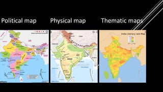
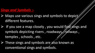
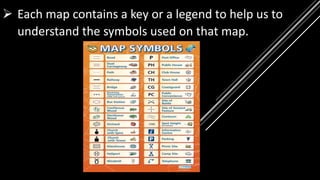
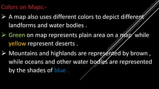
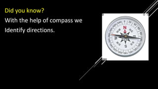
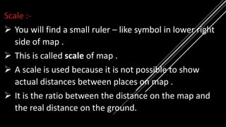
9
MAPS AND GLOBES
PARTH MAHAJAN
STD- 5TH SCHOOL :– SHANTI ASIATIC SCHOOL
DHOLKA , DISTRICT AHMEDABAD , GUJRAT.
.
 What do you think when
the ship reaches at the
horizon?
Does it disappear?
 THE VANISHING OF SHIP
TELLS THAT EARTH IS
ROUND IN SHAPE NOT
FLAT.
 In ancient time people believed that earth is flat. But
Ferdinand Magellan , a Portuguese explorer , sailed
around the Earth and proved that earth is round in
shape.
 However it is not
perfect round it is
round like orange
bulging at the
middle and slightly
flat at the top and
the bottom.
 The region at the top of
the Earth is the North
pole and at the bottom is
the South pole.
Globe :-
 A is model of the Earth.
 Globes are always mounted on an axle
Stand.
 The axle’s tilt is same as tilt of the Earth’s axis.
 A globe accurately represents the disruption of
continents and oceans on the Earth.
Problems with globes:-
 A globe does not show details of landforms , location
of small towns and other such information .
 Globe do not show the entire Earth at a time.
 Larger globes are difficult to handle.
 It is also difficult to carry globes around.
Map:-
 A world map also represents the Earth.
 It is drawing of different parts of the world on a flat
surface or on a paper.
 Maps show specific details of areas very well.
 They are also very convenient to carry.
Types of maps:-
 There are many types of map , such as political map ,
physical map and thematic map
 Political Maps: - A political map of a country, a
country shows political features of a country, such as
states, provinences, capital cities and major towns.
 Physical Maps :- The physical map shows landforms
and water bodies like mountains , plains , pleatues ,
valleys , rivers , seas and oceans.
 Thematic Maps :- Thematic maps wich show special
features of a region . Thematic maps include maps
showing distribution of rainfall , vegetation, industries
, etc .
Political map Physical map Thematic maps
Sings and Symbols :-
 Maps use various sings and symbols to depict
different features.
 If you see a map closely , you would find sings and
symbols depicting rivers , roadways , railways ,
temples , schools , etc.
 These sings and symbols are also known as
conventional sings and symbols.
 Each map contains a key or a legend to help us to
understand the symbols used on that map.
Colors on Maps:-
 A map also uses different colors to depict different
landforms and water bodies .
 Green on map represents plain area on a map while
yellow represent deserts .
 Mountains and highlands are represented by brown ,
while oceans and other water bodies are represented
by the shades of blue .
Directions and Scale :-
Directions :-
 Directions are very important to study maps.
 They are used to correctly locate a place on a map .
 There are four main directions on a map .
 They are north , south , east and west.
 There are also four sub – directions on a map . They
are:-
 North – East – between north and east
 South – East – between south and east
 South – west – between south and west
 North – West – between north and west
Did you know?
With the help of compass we
Identify directions.
Scale :-
 You will find a small ruler – like symbol in lower right
side of map .
 This is called scale of map .
 A scale is used because it is not possible to show
actual distances between places on map .
 It is the ratio between the distance on the map and
the real distance on the ground.

Maps and globes

  • 1.
  • 2.
    MAPS AND GLOBES PARTHMAHAJAN STD- 5TH SCHOOL :– SHANTI ASIATIC SCHOOL DHOLKA , DISTRICT AHMEDABAD , GUJRAT. .
  • 4.
     What doyou think when the ship reaches at the horizon? Does it disappear?
  • 5.
     THE VANISHINGOF SHIP TELLS THAT EARTH IS ROUND IN SHAPE NOT FLAT.
  • 6.
     In ancienttime people believed that earth is flat. But Ferdinand Magellan , a Portuguese explorer , sailed around the Earth and proved that earth is round in shape.
  • 7.
     However itis not perfect round it is round like orange bulging at the middle and slightly flat at the top and the bottom.
  • 8.
     The regionat the top of the Earth is the North pole and at the bottom is the South pole.
  • 9.
    Globe :-  Ais model of the Earth.  Globes are always mounted on an axle Stand.  The axle’s tilt is same as tilt of the Earth’s axis.  A globe accurately represents the disruption of continents and oceans on the Earth.
  • 10.
    Problems with globes:- A globe does not show details of landforms , location of small towns and other such information .  Globe do not show the entire Earth at a time.  Larger globes are difficult to handle.  It is also difficult to carry globes around.
  • 11.
    Map:-  A worldmap also represents the Earth.  It is drawing of different parts of the world on a flat surface or on a paper.  Maps show specific details of areas very well.  They are also very convenient to carry.
  • 12.
    Types of maps:- There are many types of map , such as political map , physical map and thematic map
  • 13.
     Political Maps:- A political map of a country, a country shows political features of a country, such as states, provinences, capital cities and major towns.  Physical Maps :- The physical map shows landforms and water bodies like mountains , plains , pleatues , valleys , rivers , seas and oceans.
  • 14.
     Thematic Maps:- Thematic maps wich show special features of a region . Thematic maps include maps showing distribution of rainfall , vegetation, industries , etc .
  • 15.
    Political map Physicalmap Thematic maps
  • 16.
    Sings and Symbols:-  Maps use various sings and symbols to depict different features.  If you see a map closely , you would find sings and symbols depicting rivers , roadways , railways , temples , schools , etc.  These sings and symbols are also known as conventional sings and symbols.
  • 17.
     Each mapcontains a key or a legend to help us to understand the symbols used on that map.
  • 18.
    Colors on Maps:- A map also uses different colors to depict different landforms and water bodies .  Green on map represents plain area on a map while yellow represent deserts .  Mountains and highlands are represented by brown , while oceans and other water bodies are represented by the shades of blue .
  • 19.
    Directions and Scale:- Directions :-  Directions are very important to study maps.  They are used to correctly locate a place on a map .
  • 20.
     There arefour main directions on a map .  They are north , south , east and west.  There are also four sub – directions on a map . They are:-
  • 21.
     North –East – between north and east  South – East – between south and east  South – west – between south and west  North – West – between north and west
  • 22.
    Did you know? Withthe help of compass we Identify directions.
  • 23.
    Scale :-  Youwill find a small ruler – like symbol in lower right side of map .  This is called scale of map .  A scale is used because it is not possible to show actual distances between places on map .  It is the ratio between the distance on the map and the real distance on the ground.