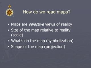
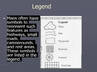
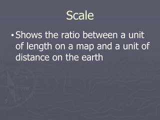
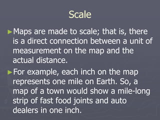
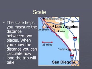
SlideShare a Scribd company logo
1 of 40
Geography/Map Skills
Social Studies
https://www.floca
bulary.com/unit/m
ap-skills/
What is a map?
• A generalized view of an area, usually
some portion of Earth’s surface, as seen
from above at a greatly reduced size
• Any geographical image of the
environment
• A two-dimensional representation of the
spatial distribution of selected
phenomena
What’s on a map?
• Maps have a lot of information, but you
need to know how to read them. There
are several parts to a map which explain
details and help you really see where you
are and where you're going.
Why make maps?
• To represent a larger area than we can see
• To show a phenomenon or process we
can’t see with our eyes
• To present information concisely
• To show spatial relationships
How do we read maps?
• Maps are selective views of reality
• Size of the map relative to reality
(scale)
• What’s on the map (symbolization)
• Shape of the map (projection)
Relative Location
• Describes a place in comparison to
other places around it
Orientation
• Direction -- usually shown on a
map using a compass rose or
directional indicator
Pie Chart
• Used to
show parts
of a whole
or
percentages
Bar graph
• Used to
show
items in
relation
to others
Line Graph
• Used to show
loss or gain or
information
over several
time frames
Legend
• Maps often have
symbols to
represent such
features as
highways, small
roads,
campgrounds,
and rest areas.
These symbols
are listed in the
legend.
Scale
• Shows the ratio between a unit
of length on a map and a unit of
distance on the earth
Scale
►Maps are made to scale; that is, there
is a direct connection between a unit of
measurement on the map and the
actual distance.
►For example, each inch on the map
represents one mile on Earth. So, a
map of a town would show a mile-long
strip of fast food joints and auto
dealers in one inch.
Scale
• The scale helps
you measure the
distance
betweeen two
places. When
you know the
distance you can
calculate how
long the trip will
take.
Map scale
• Ratio of the distance on the map to the
distance on the ground
• Scale is a fraction
• Larger area covered means larger
denominator
• Larger denominator means smaller
fraction
• So a large-scale map covers a small
area
Map scale
• Ratio of the distance on the map to the
distance on the ground
1. Graphic:
• Stays the same when photocopied
• Might not be right for the whole map
Map scale
Verbal:
1 inch equals 10 miles
• Easy to understand
• Can change if photocopied
Map scale
1. Representative fraction or ratio:
1:24,000
• Units don’t matter
• Can change if photocopied
• Ratio of the distance on the map to the
distance on the ground
• Scale is a fraction
Map symbolization
• Symbols are a code instead of text
• Three kinds: point, line, area
• Consider shape, size, orientation,
pattern, color, value
The World Political
• Political maps show how people have
divided places on the Earth into countries,
states, cities and other units for the
purpose of governing them.
The World Physical
• Physical maps show what the surface of
the Earth looks like.
Oceans of the World
• The world has four major oceans.
• Atlantic
• Pacific
• Arctic
• Indian
• Southern
Pacifi
c
ocean
Atlanti
c
ocean
Arctic
ocean
Indian
ocean
Lines of Longitude
•Imaginary lines that
measure distance east and
west of the Prime Meridian
Lines of latitude
• Imaginary lines that
measure distance north and
south of the equator
Latitude and Longitude
►The earth is divided into lots of lines
called latitude and longitude.
Lines
►Longitude lines run north and south.
►Latitude lines run east and west.
►The lines measure distances in
degrees.
Latitude
Longitude
Where is 0 degree?
►The equator is 0 degree latitude.
►It is an imaginary belt that runs
halfway point between the North Pole
and the South Pole.
Equator
Where is 0 degree?
►The prime meridian is 0 degrees
longitude. This imaginary line runs through
the United Kingdom, France, Spain, western
Africa, and Antarctica.
P
R
I
M
E
M
E
R
I
D
I
A
N
Hemispheres
►By using the equator and prime
meridian, we can divide the
world into four hemispheres,
north, south, east, and west.
Compass
• The compass
shows the
directions on
a map: north,
south, east,
and west.
Compass
►A compass is a tool that helps
the user know what direction
one is headed.
►On a map, a compass or a
compass rose helps the user
locate these directions.
Compass Rose
►The needle on a compass is
magnetized to point to the
earth's north magnetic pole.
Thus with a compass, a person
can roughly tell which direction
they are headed.
Source:
Directions
►The cardinal directions are north, south,
east, and west.
►The intermediate directions are northeast,
southeast, southwest and northwest.
►They help describe the location of places in
relation to other places.
Scale
Time Zones
►The Earth is divided into 24 time
zones, corresponding to 24 hours in a
day.
►As the earth rotates, the sun shines in
different areas, moving from east to
west during the course of a day.
►Places that have the same longitude
will be in the same time zone.
Map Legends
►The legend is the key to unlocking the
secrets of a map. Objects or colors in the
legend represent something on the map.
Religions
Legend
Age Expectancy
Legend
TIME FOR YOUR
QUIZ!!!

More Related Content

Similar to Geography_Map Skills .pptx

BOLTSS - Mapping Geography
BOLTSS - Mapping GeographyBOLTSS - Mapping Geography
BOLTSS - Mapping GeographyYaryalitsa
 
M09U01_ppt_cartograph.ppt
M09U01_ppt_cartograph.pptM09U01_ppt_cartograph.ppt
M09U01_ppt_cartograph.pptRalphNavelino3
 
Geography skills handbook1
Geography skills handbook1Geography skills handbook1
Geography skills handbook1kjanchild
 
Chapter 3 gateway 123
Chapter 3 gateway 123Chapter 3 gateway 123
Chapter 3 gateway 123MissST
 
Maps And Globes Are Models Of The Earth
Maps And Globes Are Models Of The EarthMaps And Globes Are Models Of The Earth
Maps And Globes Are Models Of The Earthmrmartella
 
Intro to world geography skills
Intro to world geography skillsIntro to world geography skills
Intro to world geography skillskarrinem
 
Map compasswacbc
Map compasswacbcMap compasswacbc
Map compasswacbcBob Coleman
 
maps & symbols which is use in india and other parts of world also
maps & symbols which is use in india and other parts of world alsomaps & symbols which is use in india and other parts of world also
maps & symbols which is use in india and other parts of world alsoLakshya Sharma
 

Similar to Geography_Map Skills .pptx (20)

BOLTSS - Mapping Geography
BOLTSS - Mapping GeographyBOLTSS - Mapping Geography
BOLTSS - Mapping Geography
 
M09U01_ppt_cartograph.ppt
M09U01_ppt_cartograph.pptM09U01_ppt_cartograph.ppt
M09U01_ppt_cartograph.ppt
 
GEOGRAPHY IGCSE: MAP SKILLS
GEOGRAPHY IGCSE: MAP SKILLSGEOGRAPHY IGCSE: MAP SKILLS
GEOGRAPHY IGCSE: MAP SKILLS
 
Readingmaps 1
Readingmaps 1Readingmaps 1
Readingmaps 1
 
Pau
PauPau
Pau
 
Pau
PauPau
Pau
 
Pau (2)
Pau (2)Pau (2)
Pau (2)
 
Geography skills handbook1
Geography skills handbook1Geography skills handbook1
Geography skills handbook1
 
Pau (2)
Pau (2)Pau (2)
Pau (2)
 
Chapter 3 gateway 123
Chapter 3 gateway 123Chapter 3 gateway 123
Chapter 3 gateway 123
 
Parts of a map
Parts of a mapParts of a map
Parts of a map
 
Map reading
Map readingMap reading
Map reading
 
Unit 1 Maps
Unit 1 MapsUnit 1 Maps
Unit 1 Maps
 
Maps And Globes Are Models Of The Earth
Maps And Globes Are Models Of The EarthMaps And Globes Are Models Of The Earth
Maps And Globes Are Models Of The Earth
 
Mapping space around us
Mapping space around usMapping space around us
Mapping space around us
 
Intro to world geography skills
Intro to world geography skillsIntro to world geography skills
Intro to world geography skills
 
Map compasswacbc
Map compasswacbcMap compasswacbc
Map compasswacbc
 
Chapter 4 maps ppt
Chapter 4 maps pptChapter 4 maps ppt
Chapter 4 maps ppt
 
maps & symbols which is use in india and other parts of world also
maps & symbols which is use in india and other parts of world alsomaps & symbols which is use in india and other parts of world also
maps & symbols which is use in india and other parts of world also
 
Maps
Maps Maps
Maps
 

Recently uploaded

Introduction to AI in Higher Education_draft.pptx
Introduction to AI in Higher Education_draft.pptxIntroduction to AI in Higher Education_draft.pptx
Introduction to AI in Higher Education_draft.pptxpboyjonauth
 
microwave assisted reaction. General introduction
microwave assisted reaction. General introductionmicrowave assisted reaction. General introduction
microwave assisted reaction. General introductionMaksud Ahmed
 
Enzyme, Pharmaceutical Aids, Miscellaneous Last Part of Chapter no 5th.pdf
Enzyme, Pharmaceutical Aids, Miscellaneous Last Part of Chapter no 5th.pdfEnzyme, Pharmaceutical Aids, Miscellaneous Last Part of Chapter no 5th.pdf
Enzyme, Pharmaceutical Aids, Miscellaneous Last Part of Chapter no 5th.pdfSumit Tiwari
 
Crayon Activity Handout For the Crayon A
Crayon Activity Handout For the Crayon ACrayon Activity Handout For the Crayon A
Crayon Activity Handout For the Crayon AUnboundStockton
 
SOCIAL AND HISTORICAL CONTEXT - LFTVD.pptx
SOCIAL AND HISTORICAL CONTEXT - LFTVD.pptxSOCIAL AND HISTORICAL CONTEXT - LFTVD.pptx
SOCIAL AND HISTORICAL CONTEXT - LFTVD.pptxiammrhaywood
 
Science 7 - LAND and SEA BREEZE and its Characteristics
Science 7 - LAND and SEA BREEZE and its CharacteristicsScience 7 - LAND and SEA BREEZE and its Characteristics
Science 7 - LAND and SEA BREEZE and its CharacteristicsKarinaGenton
 
Organic Name Reactions for the students and aspirants of Chemistry12th.pptx
Organic Name Reactions  for the students and aspirants of Chemistry12th.pptxOrganic Name Reactions  for the students and aspirants of Chemistry12th.pptx
Organic Name Reactions for the students and aspirants of Chemistry12th.pptxVS Mahajan Coaching Centre
 
A Critique of the Proposed National Education Policy Reform
A Critique of the Proposed National Education Policy ReformA Critique of the Proposed National Education Policy Reform
A Critique of the Proposed National Education Policy ReformChameera Dedduwage
 
Accessible design: Minimum effort, maximum impact
Accessible design: Minimum effort, maximum impactAccessible design: Minimum effort, maximum impact
Accessible design: Minimum effort, maximum impactdawncurless
 
How to Make a Pirate ship Primary Education.pptx
How to Make a Pirate ship Primary Education.pptxHow to Make a Pirate ship Primary Education.pptx
How to Make a Pirate ship Primary Education.pptxmanuelaromero2013
 
_Math 4-Q4 Week 5.pptx Steps in Collecting Data
_Math 4-Q4 Week 5.pptx Steps in Collecting Data_Math 4-Q4 Week 5.pptx Steps in Collecting Data
_Math 4-Q4 Week 5.pptx Steps in Collecting DataJhengPantaleon
 
Kisan Call Centre - To harness potential of ICT in Agriculture by answer farm...
Kisan Call Centre - To harness potential of ICT in Agriculture by answer farm...Kisan Call Centre - To harness potential of ICT in Agriculture by answer farm...
Kisan Call Centre - To harness potential of ICT in Agriculture by answer farm...Krashi Coaching
 
Alper Gobel In Media Res Media Component
Alper Gobel In Media Res Media ComponentAlper Gobel In Media Res Media Component
Alper Gobel In Media Res Media ComponentInMediaRes1
 
Presiding Officer Training module 2024 lok sabha elections
Presiding Officer Training module 2024 lok sabha electionsPresiding Officer Training module 2024 lok sabha elections
Presiding Officer Training module 2024 lok sabha electionsanshu789521
 
CARE OF CHILD IN INCUBATOR..........pptx
CARE OF CHILD IN INCUBATOR..........pptxCARE OF CHILD IN INCUBATOR..........pptx
CARE OF CHILD IN INCUBATOR..........pptxGaneshChakor2
 
Presentation by Andreas Schleicher Tackling the School Absenteeism Crisis 30 ...
Presentation by Andreas Schleicher Tackling the School Absenteeism Crisis 30 ...Presentation by Andreas Schleicher Tackling the School Absenteeism Crisis 30 ...
Presentation by Andreas Schleicher Tackling the School Absenteeism Crisis 30 ...EduSkills OECD
 
Concept of Vouching. B.Com(Hons) /B.Compdf
Concept of Vouching. B.Com(Hons) /B.CompdfConcept of Vouching. B.Com(Hons) /B.Compdf
Concept of Vouching. B.Com(Hons) /B.CompdfUmakantAnnand
 
Paris 2024 Olympic Geographies - an activity
Paris 2024 Olympic Geographies - an activityParis 2024 Olympic Geographies - an activity
Paris 2024 Olympic Geographies - an activityGeoBlogs
 

Recently uploaded (20)

Introduction to AI in Higher Education_draft.pptx
Introduction to AI in Higher Education_draft.pptxIntroduction to AI in Higher Education_draft.pptx
Introduction to AI in Higher Education_draft.pptx
 
microwave assisted reaction. General introduction
microwave assisted reaction. General introductionmicrowave assisted reaction. General introduction
microwave assisted reaction. General introduction
 
Enzyme, Pharmaceutical Aids, Miscellaneous Last Part of Chapter no 5th.pdf
Enzyme, Pharmaceutical Aids, Miscellaneous Last Part of Chapter no 5th.pdfEnzyme, Pharmaceutical Aids, Miscellaneous Last Part of Chapter no 5th.pdf
Enzyme, Pharmaceutical Aids, Miscellaneous Last Part of Chapter no 5th.pdf
 
Staff of Color (SOC) Retention Efforts DDSD
Staff of Color (SOC) Retention Efforts DDSDStaff of Color (SOC) Retention Efforts DDSD
Staff of Color (SOC) Retention Efforts DDSD
 
Crayon Activity Handout For the Crayon A
Crayon Activity Handout For the Crayon ACrayon Activity Handout For the Crayon A
Crayon Activity Handout For the Crayon A
 
SOCIAL AND HISTORICAL CONTEXT - LFTVD.pptx
SOCIAL AND HISTORICAL CONTEXT - LFTVD.pptxSOCIAL AND HISTORICAL CONTEXT - LFTVD.pptx
SOCIAL AND HISTORICAL CONTEXT - LFTVD.pptx
 
Science 7 - LAND and SEA BREEZE and its Characteristics
Science 7 - LAND and SEA BREEZE and its CharacteristicsScience 7 - LAND and SEA BREEZE and its Characteristics
Science 7 - LAND and SEA BREEZE and its Characteristics
 
Organic Name Reactions for the students and aspirants of Chemistry12th.pptx
Organic Name Reactions  for the students and aspirants of Chemistry12th.pptxOrganic Name Reactions  for the students and aspirants of Chemistry12th.pptx
Organic Name Reactions for the students and aspirants of Chemistry12th.pptx
 
A Critique of the Proposed National Education Policy Reform
A Critique of the Proposed National Education Policy ReformA Critique of the Proposed National Education Policy Reform
A Critique of the Proposed National Education Policy Reform
 
Model Call Girl in Bikash Puri Delhi reach out to us at 🔝9953056974🔝
Model Call Girl in Bikash Puri  Delhi reach out to us at 🔝9953056974🔝Model Call Girl in Bikash Puri  Delhi reach out to us at 🔝9953056974🔝
Model Call Girl in Bikash Puri Delhi reach out to us at 🔝9953056974🔝
 
Accessible design: Minimum effort, maximum impact
Accessible design: Minimum effort, maximum impactAccessible design: Minimum effort, maximum impact
Accessible design: Minimum effort, maximum impact
 
How to Make a Pirate ship Primary Education.pptx
How to Make a Pirate ship Primary Education.pptxHow to Make a Pirate ship Primary Education.pptx
How to Make a Pirate ship Primary Education.pptx
 
_Math 4-Q4 Week 5.pptx Steps in Collecting Data
_Math 4-Q4 Week 5.pptx Steps in Collecting Data_Math 4-Q4 Week 5.pptx Steps in Collecting Data
_Math 4-Q4 Week 5.pptx Steps in Collecting Data
 
Kisan Call Centre - To harness potential of ICT in Agriculture by answer farm...
Kisan Call Centre - To harness potential of ICT in Agriculture by answer farm...Kisan Call Centre - To harness potential of ICT in Agriculture by answer farm...
Kisan Call Centre - To harness potential of ICT in Agriculture by answer farm...
 
Alper Gobel In Media Res Media Component
Alper Gobel In Media Res Media ComponentAlper Gobel In Media Res Media Component
Alper Gobel In Media Res Media Component
 
Presiding Officer Training module 2024 lok sabha elections
Presiding Officer Training module 2024 lok sabha electionsPresiding Officer Training module 2024 lok sabha elections
Presiding Officer Training module 2024 lok sabha elections
 
CARE OF CHILD IN INCUBATOR..........pptx
CARE OF CHILD IN INCUBATOR..........pptxCARE OF CHILD IN INCUBATOR..........pptx
CARE OF CHILD IN INCUBATOR..........pptx
 
Presentation by Andreas Schleicher Tackling the School Absenteeism Crisis 30 ...
Presentation by Andreas Schleicher Tackling the School Absenteeism Crisis 30 ...Presentation by Andreas Schleicher Tackling the School Absenteeism Crisis 30 ...
Presentation by Andreas Schleicher Tackling the School Absenteeism Crisis 30 ...
 
Concept of Vouching. B.Com(Hons) /B.Compdf
Concept of Vouching. B.Com(Hons) /B.CompdfConcept of Vouching. B.Com(Hons) /B.Compdf
Concept of Vouching. B.Com(Hons) /B.Compdf
 
Paris 2024 Olympic Geographies - an activity
Paris 2024 Olympic Geographies - an activityParis 2024 Olympic Geographies - an activity
Paris 2024 Olympic Geographies - an activity
 

Geography_Map Skills .pptx

  • 2. What is a map? • A generalized view of an area, usually some portion of Earth’s surface, as seen from above at a greatly reduced size • Any geographical image of the environment • A two-dimensional representation of the spatial distribution of selected phenomena
  • 3. What’s on a map? • Maps have a lot of information, but you need to know how to read them. There are several parts to a map which explain details and help you really see where you are and where you're going.
  • 4. Why make maps? • To represent a larger area than we can see • To show a phenomenon or process we can’t see with our eyes • To present information concisely • To show spatial relationships
  • 5. How do we read maps? • Maps are selective views of reality • Size of the map relative to reality (scale) • What’s on the map (symbolization) • Shape of the map (projection)
  • 6. Relative Location • Describes a place in comparison to other places around it
  • 7. Orientation • Direction -- usually shown on a map using a compass rose or directional indicator
  • 8. Pie Chart • Used to show parts of a whole or percentages
  • 9. Bar graph • Used to show items in relation to others
  • 10. Line Graph • Used to show loss or gain or information over several time frames
  • 11. Legend • Maps often have symbols to represent such features as highways, small roads, campgrounds, and rest areas. These symbols are listed in the legend.
  • 12. Scale • Shows the ratio between a unit of length on a map and a unit of distance on the earth
  • 13. Scale ►Maps are made to scale; that is, there is a direct connection between a unit of measurement on the map and the actual distance. ►For example, each inch on the map represents one mile on Earth. So, a map of a town would show a mile-long strip of fast food joints and auto dealers in one inch.
  • 14. Scale • The scale helps you measure the distance betweeen two places. When you know the distance you can calculate how long the trip will take.
  • 15. Map scale • Ratio of the distance on the map to the distance on the ground • Scale is a fraction • Larger area covered means larger denominator • Larger denominator means smaller fraction • So a large-scale map covers a small area
  • 16. Map scale • Ratio of the distance on the map to the distance on the ground 1. Graphic: • Stays the same when photocopied • Might not be right for the whole map
  • 17. Map scale Verbal: 1 inch equals 10 miles • Easy to understand • Can change if photocopied
  • 18. Map scale 1. Representative fraction or ratio: 1:24,000 • Units don’t matter • Can change if photocopied • Ratio of the distance on the map to the distance on the ground • Scale is a fraction
  • 19. Map symbolization • Symbols are a code instead of text • Three kinds: point, line, area • Consider shape, size, orientation, pattern, color, value
  • 20. The World Political • Political maps show how people have divided places on the Earth into countries, states, cities and other units for the purpose of governing them.
  • 21. The World Physical • Physical maps show what the surface of the Earth looks like.
  • 22. Oceans of the World • The world has four major oceans. • Atlantic • Pacific • Arctic • Indian • Southern Pacifi c ocean Atlanti c ocean Arctic ocean Indian ocean
  • 23. Lines of Longitude •Imaginary lines that measure distance east and west of the Prime Meridian
  • 24. Lines of latitude • Imaginary lines that measure distance north and south of the equator
  • 25. Latitude and Longitude ►The earth is divided into lots of lines called latitude and longitude.
  • 26. Lines ►Longitude lines run north and south. ►Latitude lines run east and west. ►The lines measure distances in degrees. Latitude Longitude
  • 27. Where is 0 degree? ►The equator is 0 degree latitude. ►It is an imaginary belt that runs halfway point between the North Pole and the South Pole. Equator
  • 28. Where is 0 degree? ►The prime meridian is 0 degrees longitude. This imaginary line runs through the United Kingdom, France, Spain, western Africa, and Antarctica. P R I M E M E R I D I A N
  • 29.
  • 30. Hemispheres ►By using the equator and prime meridian, we can divide the world into four hemispheres, north, south, east, and west.
  • 31.
  • 32. Compass • The compass shows the directions on a map: north, south, east, and west.
  • 33. Compass ►A compass is a tool that helps the user know what direction one is headed. ►On a map, a compass or a compass rose helps the user locate these directions.
  • 34. Compass Rose ►The needle on a compass is magnetized to point to the earth's north magnetic pole. Thus with a compass, a person can roughly tell which direction they are headed. Source:
  • 35. Directions ►The cardinal directions are north, south, east, and west. ►The intermediate directions are northeast, southeast, southwest and northwest. ►They help describe the location of places in relation to other places.
  • 36. Scale
  • 37. Time Zones ►The Earth is divided into 24 time zones, corresponding to 24 hours in a day. ►As the earth rotates, the sun shines in different areas, moving from east to west during the course of a day. ►Places that have the same longitude will be in the same time zone.
  • 38. Map Legends ►The legend is the key to unlocking the secrets of a map. Objects or colors in the legend represent something on the map. Religions Legend