Topographic map with animation
•Download as PPT, PDF•
4 likes•9,210 views
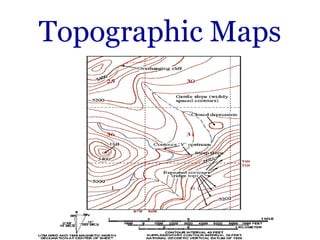
The document discusses topographic maps and how they use contour lines to show elevations and terrain. It explains that contour lines connect points of equal elevation and how they can be used to interpret slopes, ridges and valleys. The document then provides an example of following a hike on a topographic map and interpreting elevations at different points. It concludes with a short quiz to test the reader's understanding of reading elevations from the sample map.
Report
Share
Report
Share
![What is a Topographic Map? ,[object Object]](data:image/gif;base64,R0lGODlhAQABAIAAAAAAAP///yH5BAEAAAAALAAAAAABAAEAAAIBRAA7)
Recommended
LEVELING AND CONTOURING
Leveling is a surveying technique used to determine differences in elevation between points. It involves measuring vertical distances between a fixed benchmark and other points using a leveling instrument, leveling rod, and trigonometric leveling. There are two main methods for leveling - the height of instrument method and rise and fall method. Leveling is used to establish elevations, construct contour maps, and determine cut/fill volumes for engineering projects.
Topography and its representation
This topic includes representation of topography by various non mathematical and mathematical methods.
Pictorial method (Hachure lines, Hill shading)
Mathematical method (Spot heights,Bench marks, Trigonometrical stations, Layer tint or altitude tints, Contour lines )
Combination of different methods
Topographic Maps Notes
This document provides information about topographic maps, including:
1. Topographic maps show elevation, shape of the earth's surface using contour lines connecting points of equal elevation. Features like water, terrain, and human structures are shown through different colors and patterns.
2. Contour lines indicate elevation changes - closely spaced lines show steep slopes, widely spaced show gentle slopes. Contour lines never cross or branch. When crossing streams, they bend upstream. Closed contours indicate hills and depressions.
3. Topographic profiles show elevation changes along a line, often with vertical exaggeration to emphasize details. Gradient is the steepness of a slope. Constructing profiles involves connecting elevation points along a contour line slice
Reading a topographic map
Topographic maps show elevation and surface features of land using contour lines to connect points of equal height. Contour lines never cross and indicate slope - closely spaced lines mean steep slopes while lines far apart indicate flat land. Topographic maps are used to understand the shape and elevation of the land.
Geomorphology of bangladesh
This document discusses the geomorphology of Bangladesh. It defines geomorphology as the scientific study of landforms and their nature, origin, and composition. It notes that studying geomorphology is important for remote sensing, soil science, agriculture, erosion protection, rehabilitation projects, geology, petrology, and evolutionary studies. It also provides information on anastomosing channels, geology and civil engineering applications, river engineering and morphology, and lists some of Bangladesh's major rivers.
Surveying with gps
GPS has become a standard surveying technique due to its ease of use and reduced hardware costs. There are several GPS surveying techniques that can be used singly or in combination depending on the required accuracy, equipment availability, and project conditions. The most common techniques are static, fast static, kinematic, pseudo-kinematic and real-time kinematic. Each technique has advantages and limitations regarding accuracy, efficiency and data collection requirements. Careful planning is important to select the appropriate technique(s) for a given project.
Surveying & prismatic compass survey
This document discusses various topics related to surveying including: the objectives and processes involved in surveying like decision making, fieldwork, data processing, mapping, and stakeout; different types of surveys like plane, geodetic, topographic, route, hydrographic, land, and military surveys; instruments used like theodolites, tacheometers, planes tables, and compasses; and concepts like bearings, meridians, and reducing bearings. The key aspects covered are the goal of producing maps, the consideration or disregard of earth's curvature depending on survey type, and classification based on area, instruments, or purpose.
2.characteristics of countours
This document contains a lecture on contour mapping given by Mohd Salman Ahmed, a lecturer in civil engineering at Ahmed's Institute of Excellence. The lecture discusses the characteristics of contours, how to read contour plans, and how to interpret information from contour maps. Key points covered include that contours have the same elevation, spacing depends on slope, closed contours indicate hills or depressions, and contours cannot cross except at overhanging cliffs. The document provides examples and a short quiz to assess understanding.
1.1 Linear measurement original: Chaining & Ranging
This presentation cover only chain surveying using chain and tape, and required instruments. it also covers methods of ranging.
Theodolite Surveying
Surveying is an important part of Civil engineering. Various part like theodolite, plane table surveying, computation of area and volume are useful for all university examination and other competitive examination
tacheometry surveying
Tacheometry is a surveying method that uses optical instruments like a theodolite fitted with a stadia diaphragm to measure horizontal and vertical distances between points. It works on the principle that the ratio of distance from the instrument to the base of an isosceles triangle and the length of the base is constant. Distances are calculated using stadia intercept readings and multiplying constants based on the focal length of the instrument's objective lens. Tacheometry offers faster measurement compared to traditional chaining and is useful for surveys in difficult terrain like rivers, valleys, or undulating ground where conventional surveying would be inaccurate or slow.
7 slopes and slope stability
1. Mass wasting refers to the downslope movement of rock and soil due to gravity. It occurs on all slopes and can range from very slow to sudden movements.
2. The stability of a slope depends on a balance between the downward force of gravity and friction/shear strength resisting movement. Steeper slopes and saturated soils or rock are more prone to failures.
3. Common landslide types include rotational slumps and translational slides, which move along concave and planar surfaces, respectively. Earthquakes and rapid addition of water can also trigger landslides.
ROCKS AS A CONSTRUCTION MATERIAL
Rocks are used in various purpose like building material, in foundation, as railway ballast,in dam etc. That's why careful studies bring out the inherent advantage and disadvantage of a site and such studies go a long way either in reducing or in increasing the cost of the structure.
Contouring Survey.ppt
This document discusses contouring and contour maps. It defines a contour as an imaginary line connecting points of equal elevation. Contour maps show elevations and depressions of terrain through contour lines. The vertical distance between contours is the contour interval, while the horizontal distance is the equivalent. Contour characteristics include closer spacing on hills and wider on flats. Contours do not merge or end and indicate terrain features. Contour maps are used for engineering projects, determining drainage areas and more. Contours can be located directly by tracing or indirectly using squares, cross-sections or radiation methods.
Levelling
Element Of Civil Engineering subject as per GTU syllabus 1st sem carry out all content. also usefull for general idea about civil branch.
Numbering system of topographical map
The document discusses topographic maps and their numbering systems in India. It provides details on:
1) Topographic maps represent relief and also show features like transportation and settlements. They contain information like names, scales, and features.
2) In India, the Survey of India prepares topographic maps. Maps are part of two series - the India and Adjacent Country Series and the International Map of the World Series.
3) The India and Adjacent Country Series covers India in grids numbered from 40-92 that are divided into degree, quadrant, and special sheets at various scales with contour intervals.
Introduction and types of soil mechanics
The document provides an introduction to soil mechanics and soil types. It defines soil mechanics as the branch of engineering that deals with the properties and behavior of soil. It discusses the different types of soils based on their geological origin such as glacial soil, residual soil, alluvial soil, and aeolian soil. It also classifies soils based on engineering properties such as clay, silt, sand, gravel, cobbles, and boulders. The key factors that influence the engineering behavior of soils like particle size, shape, mineral composition are also highlighted.
water quality assessment of groundwater
groundwater quality assessment by WQI and correlation Analysis of both groundwater sample where the collected.
Ch 2 latitude and longitude
This document discusses latitude and longitude lines. It explains that latitudes are horizontal lines that run east to west and encircle the Earth in parallel circles. Longitudes run north to south and are used to calculate time differences between locations. The prime meridian passes through Greenwich, England at 0 degrees. Locations are precisely located using their latitude and longitude coordinates where the lines intersect.
topographic maps
Topographic maps provide three-dimensional information about landforms and structures through the use of contour lines. Contour lines connect points of equal elevation and allow the reader to determine elevation, slope steepness, and identify natural and manmade features of the landscape. Topographic maps are used by engineers, the military, and for recreational activities like hiking.
Engineering surveying-ii
This document provides an outline for a course on Engineering Surveying II taught by Prof. Dr.-Ing. John Bosco Kyalo Kiema at the University of Nairobi. The course covers topics such as horizontal control through traversing, vertical control through leveling, applications to highway drainage and earthworks, and practical field surveying. Assessment includes exams, coursework, and a term paper on the role of geoinformatics in environmental monitoring and management. The lecture outline provides details on traversing, vertical control, earthworks computations, and references textbooks on surveying.
Theodolite surveying
This document discusses the use of a theodolite for surveying. It begins by explaining that a theodolite is needed to precisely measure horizontal and vertical angles, unlike a compass. It then defines theodolite surveying as surveying that measures angles using a theodolite. The document goes on to classify theodolites based on their horizontal axis and method of angle measurement. It describes the basic parts of a transit vernier theodolite and explains terms used in manipulating one. Finally, it discusses methods for measuring horizontal angles, including the general, repetition, and reiteration methods.
STRUCTURE AND COMPOSITION OF EARTH
The document summarizes the three main layers that make up the structure of the Earth:
1. The crust is the outermost layer and is divided into continental and oceanic crust. The continental crust is thicker while the oceanic crust is thinner.
2. The mantle is the largest layer and is divided into upper and lower mantle. It is composed mainly of iron and magnesium and contains most of the Earth's internal heat.
3. The core is divided into a solid inner core and liquid outer core. The outer core is responsible for the Earth's magnetic field and rotation, while the inner core is made mostly of solid iron.
Scope of studying engineering geology
Engineering geology involves applying geological principles to engineering projects. It requires studying the geology of an area to ensure geological factors will not negatively impact projects. The document outlines the basic knowledge required for engineering geology, which includes understanding rock and soil types, their properties, and how they are influenced by geologic processes and structures. It also discusses various methods used in geological investigations and their applications to engineering projects.
Digital Elevation Model (DEM)
This document defines and describes Digital Elevation Models (DEMs). It discusses that DEMs are 3D representations of land surface elevation from various data sources. There are two main types of DEMs - raster and vector (TIN). Data can be captured through remote sensing, photogrammetry, or land surveys. Free global DEMs are available from sources like SRTM, ASTER, and ALOS. DEMs have many applications including terrain analysis, hydrology, mapping, and more.
Geomorpholgy: NATURE AND SCOPE
Geomorphology is the study of landforms and the processes that shape them. It is a branch of physical geography that analyzes relief features at different dimensions and scales. Relief features are organized into three orders based on size: first order includes continents and ocean basins shaped by plate tectics; second order consists of structural landforms like mountains and plateaus formed by constructional forces; third order comprises micro-level erosional and depositional landforms developed on second order features by exogenic processes like rivers and glaciers. Process geomorphology examines specialized subfields defined by the dominant shaping process, such as fluvial, glacial, coastal and karst landforms.
Surveying ppt : COMPONENETS OF TRANSIT THEODOLITE
The document describes the main components of a transit theodolite. It lists 12 key components: 1) trivet, 2) foot screws, 3) tri branch, 4) leveling head, 5) spindles, 6) lower plate, 7) upper plate, 8) A frame, 9) T frame, 10) altitude bubble, 11) compass, and 12) tripod. The lower plate measures horizontal angles with graduations from 0 to 360 degrees. The upper plate has two verniers used to read fractions of degrees on the lower plate. The tripod supports the theodolite during field use.
Plane Table Survey
Plane table surveying involves simultaneously conducting fieldwork and plotting details on a drawing board called a plane table. Key accessories include an alidade for sighting, a spirit level and magnetic compass. Common methods are the radiation, intersection and traversing methods which involve measuring distances and angles to map features. Care is needed to accurately orient and center the plane table between stations. While suitable for small-scale mapping, plane table surveying is not intended for highly accurate work.
Weather and Climate
The document discusses various weather and climate concepts including:
- Weather is the current atmospheric conditions while climate is the average weather over time.
- High pressure systems are associated with clear skies and dry conditions while low pressure systems bring clouds and rain.
- Weather maps use lines of equal pressure (isobars) and symbols to show wind speed and direction helping predict future conditions.
BOLTSS - Mapping Geography
BOLTSS
Mapping Geography
Acronym: BOLTSS
Border - Orientation - Legend - Title -- Scale - Source
Six (6) essential features of a MAP.
More Related Content
What's hot
1.1 Linear measurement original: Chaining & Ranging
This presentation cover only chain surveying using chain and tape, and required instruments. it also covers methods of ranging.
Theodolite Surveying
Surveying is an important part of Civil engineering. Various part like theodolite, plane table surveying, computation of area and volume are useful for all university examination and other competitive examination
tacheometry surveying
Tacheometry is a surveying method that uses optical instruments like a theodolite fitted with a stadia diaphragm to measure horizontal and vertical distances between points. It works on the principle that the ratio of distance from the instrument to the base of an isosceles triangle and the length of the base is constant. Distances are calculated using stadia intercept readings and multiplying constants based on the focal length of the instrument's objective lens. Tacheometry offers faster measurement compared to traditional chaining and is useful for surveys in difficult terrain like rivers, valleys, or undulating ground where conventional surveying would be inaccurate or slow.
7 slopes and slope stability
1. Mass wasting refers to the downslope movement of rock and soil due to gravity. It occurs on all slopes and can range from very slow to sudden movements.
2. The stability of a slope depends on a balance between the downward force of gravity and friction/shear strength resisting movement. Steeper slopes and saturated soils or rock are more prone to failures.
3. Common landslide types include rotational slumps and translational slides, which move along concave and planar surfaces, respectively. Earthquakes and rapid addition of water can also trigger landslides.
ROCKS AS A CONSTRUCTION MATERIAL
Rocks are used in various purpose like building material, in foundation, as railway ballast,in dam etc. That's why careful studies bring out the inherent advantage and disadvantage of a site and such studies go a long way either in reducing or in increasing the cost of the structure.
Contouring Survey.ppt
This document discusses contouring and contour maps. It defines a contour as an imaginary line connecting points of equal elevation. Contour maps show elevations and depressions of terrain through contour lines. The vertical distance between contours is the contour interval, while the horizontal distance is the equivalent. Contour characteristics include closer spacing on hills and wider on flats. Contours do not merge or end and indicate terrain features. Contour maps are used for engineering projects, determining drainage areas and more. Contours can be located directly by tracing or indirectly using squares, cross-sections or radiation methods.
Levelling
Element Of Civil Engineering subject as per GTU syllabus 1st sem carry out all content. also usefull for general idea about civil branch.
Numbering system of topographical map
The document discusses topographic maps and their numbering systems in India. It provides details on:
1) Topographic maps represent relief and also show features like transportation and settlements. They contain information like names, scales, and features.
2) In India, the Survey of India prepares topographic maps. Maps are part of two series - the India and Adjacent Country Series and the International Map of the World Series.
3) The India and Adjacent Country Series covers India in grids numbered from 40-92 that are divided into degree, quadrant, and special sheets at various scales with contour intervals.
Introduction and types of soil mechanics
The document provides an introduction to soil mechanics and soil types. It defines soil mechanics as the branch of engineering that deals with the properties and behavior of soil. It discusses the different types of soils based on their geological origin such as glacial soil, residual soil, alluvial soil, and aeolian soil. It also classifies soils based on engineering properties such as clay, silt, sand, gravel, cobbles, and boulders. The key factors that influence the engineering behavior of soils like particle size, shape, mineral composition are also highlighted.
water quality assessment of groundwater
groundwater quality assessment by WQI and correlation Analysis of both groundwater sample where the collected.
Ch 2 latitude and longitude
This document discusses latitude and longitude lines. It explains that latitudes are horizontal lines that run east to west and encircle the Earth in parallel circles. Longitudes run north to south and are used to calculate time differences between locations. The prime meridian passes through Greenwich, England at 0 degrees. Locations are precisely located using their latitude and longitude coordinates where the lines intersect.
topographic maps
Topographic maps provide three-dimensional information about landforms and structures through the use of contour lines. Contour lines connect points of equal elevation and allow the reader to determine elevation, slope steepness, and identify natural and manmade features of the landscape. Topographic maps are used by engineers, the military, and for recreational activities like hiking.
Engineering surveying-ii
This document provides an outline for a course on Engineering Surveying II taught by Prof. Dr.-Ing. John Bosco Kyalo Kiema at the University of Nairobi. The course covers topics such as horizontal control through traversing, vertical control through leveling, applications to highway drainage and earthworks, and practical field surveying. Assessment includes exams, coursework, and a term paper on the role of geoinformatics in environmental monitoring and management. The lecture outline provides details on traversing, vertical control, earthworks computations, and references textbooks on surveying.
Theodolite surveying
This document discusses the use of a theodolite for surveying. It begins by explaining that a theodolite is needed to precisely measure horizontal and vertical angles, unlike a compass. It then defines theodolite surveying as surveying that measures angles using a theodolite. The document goes on to classify theodolites based on their horizontal axis and method of angle measurement. It describes the basic parts of a transit vernier theodolite and explains terms used in manipulating one. Finally, it discusses methods for measuring horizontal angles, including the general, repetition, and reiteration methods.
STRUCTURE AND COMPOSITION OF EARTH
The document summarizes the three main layers that make up the structure of the Earth:
1. The crust is the outermost layer and is divided into continental and oceanic crust. The continental crust is thicker while the oceanic crust is thinner.
2. The mantle is the largest layer and is divided into upper and lower mantle. It is composed mainly of iron and magnesium and contains most of the Earth's internal heat.
3. The core is divided into a solid inner core and liquid outer core. The outer core is responsible for the Earth's magnetic field and rotation, while the inner core is made mostly of solid iron.
Scope of studying engineering geology
Engineering geology involves applying geological principles to engineering projects. It requires studying the geology of an area to ensure geological factors will not negatively impact projects. The document outlines the basic knowledge required for engineering geology, which includes understanding rock and soil types, their properties, and how they are influenced by geologic processes and structures. It also discusses various methods used in geological investigations and their applications to engineering projects.
Digital Elevation Model (DEM)
This document defines and describes Digital Elevation Models (DEMs). It discusses that DEMs are 3D representations of land surface elevation from various data sources. There are two main types of DEMs - raster and vector (TIN). Data can be captured through remote sensing, photogrammetry, or land surveys. Free global DEMs are available from sources like SRTM, ASTER, and ALOS. DEMs have many applications including terrain analysis, hydrology, mapping, and more.
Geomorpholgy: NATURE AND SCOPE
Geomorphology is the study of landforms and the processes that shape them. It is a branch of physical geography that analyzes relief features at different dimensions and scales. Relief features are organized into three orders based on size: first order includes continents and ocean basins shaped by plate tectics; second order consists of structural landforms like mountains and plateaus formed by constructional forces; third order comprises micro-level erosional and depositional landforms developed on second order features by exogenic processes like rivers and glaciers. Process geomorphology examines specialized subfields defined by the dominant shaping process, such as fluvial, glacial, coastal and karst landforms.
Surveying ppt : COMPONENETS OF TRANSIT THEODOLITE
The document describes the main components of a transit theodolite. It lists 12 key components: 1) trivet, 2) foot screws, 3) tri branch, 4) leveling head, 5) spindles, 6) lower plate, 7) upper plate, 8) A frame, 9) T frame, 10) altitude bubble, 11) compass, and 12) tripod. The lower plate measures horizontal angles with graduations from 0 to 360 degrees. The upper plate has two verniers used to read fractions of degrees on the lower plate. The tripod supports the theodolite during field use.
Plane Table Survey
Plane table surveying involves simultaneously conducting fieldwork and plotting details on a drawing board called a plane table. Key accessories include an alidade for sighting, a spirit level and magnetic compass. Common methods are the radiation, intersection and traversing methods which involve measuring distances and angles to map features. Care is needed to accurately orient and center the plane table between stations. While suitable for small-scale mapping, plane table surveying is not intended for highly accurate work.
What's hot (20)
1.1 Linear measurement original: Chaining & Ranging
1.1 Linear measurement original: Chaining & Ranging
Viewers also liked
Weather and Climate
The document discusses various weather and climate concepts including:
- Weather is the current atmospheric conditions while climate is the average weather over time.
- High pressure systems are associated with clear skies and dry conditions while low pressure systems bring clouds and rain.
- Weather maps use lines of equal pressure (isobars) and symbols to show wind speed and direction helping predict future conditions.
BOLTSS - Mapping Geography
BOLTSS
Mapping Geography
Acronym: BOLTSS
Border - Orientation - Legend - Title -- Scale - Source
Six (6) essential features of a MAP.
Topography powerpoint
The document defines and explains topography and topographic maps. It describes how topographic maps use contour lines to represent elevation, with closer lines indicating steeper slopes. Contour lines circle around mountains and point upstream along streams. Other symbols convey features like roads, vegetation, buildings and landforms. Index contours are labeled to indicate the contour interval elevation difference between lines. Topographic maps provide visual information about natural and man-made terrain.
Topographic maps presentation_mine
Topographic maps use contour lines to represent elevation and slope of land. Contour lines connect points of equal elevation and never cross. Closer lines indicate steeper slopes while widely spaced lines show more gentle slopes. Index contours are bold lines labeled with the elevation. A benchmark is a point of known exact elevation marked as B.M. on maps. Map scale relates distances on a map to actual distances on land and can be ratio, graphical, or verbal.
Secondary 1 Geography-Topographic Map
Topographic maps use a grid system of eastings and northings to locate features. Grid references specify the grid square and exact location of a feature. Compass directions and bearings are used to determine the orientation between locations. Distances on a map are measured using a ruler and scale, while curved distances use a string. Contours connect areas of equal height and indicate terrain features like hills, mountains, valleys, plateaus and ridges based on their shape and steepness.
What is Topography
This document provides an overview of the early history and development of the theory of plate tectonics. It discusses how early maps from Eratosthenes and Crates began to document topography and elevation patterns on Earth. In the late 1800s, scientists like Alexander von Humboldt, Antonio Snider-Pellegrini, and Edward Seuss began recognizing patterns in the shapes and fossil records of continents that suggested they were once joined together. In the early 1900s, scientists like Frank Taylor and Alfred Wegener proposed the first hypotheses of continental drift to explain these patterns, though Wegener's ideas faced skepticism at the time due to the unknown forces driving plate motions.
Class X ICSE Geography Solved Question Paper
This document provides instructions for a geography exam, including information about the exam format, timing, and map provided. It outlines 7 questions to attempt from 2 parts. Part I is compulsory and contains short answer questions about the provided map extract. Part II has 2 sections with longer answer questions about geography of South Asia, India, and climate.
Topographic Maps
This document provides information about topographic maps and how to interpret contour lines and intervals. It explains that contour lines connect points of equal elevation and the contour interval is the distance between lines. It describes how to determine elevations, slope steepness, gradient, and the use of depression contours to show temporary elevation changes. The document uses examples and quizzes to help the reader learn to interpret elevation, slope, and other topographic features from contour maps.
Basics of Map reading
The document defines maps and their key components. It discusses the main types of maps, including political, physical, weather, road, and climatic maps. It explains that the Earth is divided into lines of latitude and longitude that are used to locate positions. Latitude lines run east to west and are parallel, while longitude lines run north to south and converge at the poles. The main features of maps, such as the equator, hemispheres, prime meridian, parallels, and meridians are outlined.
LS GE Slides - Map Reading
The document provides information on how to read and interpret topographical maps. It discusses key elements of maps including symbols, scale, contour lines, and compass use. Maps are representations of land or sea that use symbols to denote physical and human features. Contour lines connect points of equal elevation, with closer lines indicating steeper slopes. A compass is used to find cardinal and intercardinal directions as well as compass bearings between points. Scale relates distances on a map to actual ground distances.
Contouring
The document provides information on contouring and contour maps. It defines a contour as an imaginary line joining points of equal elevation. Contour maps show contour lines and provide information on surface altitudes and relative positions. The process of tracing contour lines is called contouring. Contour surveys are conducted for engineering projects to select sites, locate alignments, and minimize earthworks. The constant vertical distance between contours is the contour interval, while the horizontal distance varies based on slope. Contour interpolation involves proportionally spacing contours between plotted ground points based on assumed uniform slopes.
Powerpoint ..biomes
The document summarizes the major terrestrial biomes of the world. It describes the six biomes as: 1) Desert biome, which is characterized by hot and dry climates with less than 10 inches of rain per year. Common plants include cacti and animals have adaptations for heat and lack of water. 2) Tundra biome, which is located north of the Arctic circle and is the coldest biome with less than 25 inches of rain per year. Plants are low growing and animals have thick fur. 3) Taiga biome or boreal forest, located in northern parts of North America, Asia, and Europe. It has long, cold winters and coniferous trees are abundant. 4) Rainforest biome
Class X geography question bank
Class X geography question bank will help you to prepare for your ICSE Examinations.Go through each and every question.
BEST OF LUCK!!
Weekly Food Consumption Around the World
This presentation shows families around the world and how much per week they consume and spend on food. It's pretty startling!
Chapter 3 gateway 123 combined
This document discusses key geographical skills and investigations, including topographical map reading skills, geographical data techniques, and geographical investigations. It covers topics such as reading topographical maps, interpreting scales, measuring distances, describing relief features, identifying landforms, calculating gradients, interpreting map symbols, describing patterns of vegetation and land use, and explaining relationships between relief and land use. It also discusses using photographs, satellite images, and different types of graphs to depict and analyze geographical data.
Map Reading
This document provides an overview of key elements of map reading including:
1. The main components of a map including title, scale, legend, grid lines, and north arrows.
2. Grid systems and references for locating positions on a map.
3. How to determine distances and directions using map scales, bearings, and cardinal points.
4. Methods for identifying one's own location including resection and using known lines/features.
5. Techniques for locating other positions including intersection and using azimuth and distance.
Contouring pdf
The document discusses contouring and contour maps. It begins with definitions of key terms like contour, contour interval, and horizontal equivalent. It then describes the characteristics of contours, such as contours of equal elevation joining to indicate terrain features like hills and depressions. The methods of creating contours and their common uses are outlined, such as determining cut and fill volumes for engineering projects. Specific topics covered in the document include determining slope steepness from contour spacing, identifying ridges and valleys, and factors that determine the contour interval.
Map reading
This document provides guidance on important map reading skills for a geography exam, including how to locate places using grid references, calculate bearings, gradients, distances, and interpret cross-sections, drainage patterns, landforms, and the relationship between landforms and human activities. Key topics covered are grid references, scales, bearings, gradients, cross-sections, describing drainage, landforms, and how landforms influence settlement, agriculture, and transport networks. Students are advised to practice these skills in preparation for the compulsory map reading question.
Stations lab
This document provides instructions for making a contour map from elevation data measured in meters. The contour interval is 10 meters. Students are directed to highlight data points that are multiples of 10 meters, and connect them with contour lines that separate higher and lower elevations. The lowest value on the map is to be highlighted first.
Map & a diagram (1)
A topographical map shows both natural and man-made features using contour lines and colors to represent elevation, terrain, and land use. Contour lines connect points of equal height and indicate the steepness of slopes. Common topographical map symbols and features include contour intervals, spot heights, settlements, drainage patterns, vegetation, infrastructure like roads and railroads, and land use patterns related to occupations. Topographical maps are scaled and use a grid system of eastings and northings to precisely locate points.
Viewers also liked (20)
Recently uploaded
Temple of Asclepius in Thrace. Excavation results
The temple and the sanctuary around were dedicated to Asklepios Zmidrenus. This name has been known since 1875 when an inscription dedicated to him was discovered in Rome. The inscription is dated in 227 AD and was left by soldiers originating from the city of Philippopolis (modern Plovdiv).
Traditional Musical Instruments of Arunachal Pradesh and Uttar Pradesh - RAYH...
Traditional Musical Instruments of Arunachal Pradesh and Uttar Pradesh
What is Digital Literacy? A guest blog from Andy McLaughlin, University of Ab...
What is Digital Literacy? A guest blog from Andy McLaughlin, University of Aberdeen
ISO/IEC 27001, ISO/IEC 42001, and GDPR: Best Practices for Implementation and...
Denis is a dynamic and results-driven Chief Information Officer (CIO) with a distinguished career spanning information systems analysis and technical project management. With a proven track record of spearheading the design and delivery of cutting-edge Information Management solutions, he has consistently elevated business operations, streamlined reporting functions, and maximized process efficiency.
Certified as an ISO/IEC 27001: Information Security Management Systems (ISMS) Lead Implementer, Data Protection Officer, and Cyber Risks Analyst, Denis brings a heightened focus on data security, privacy, and cyber resilience to every endeavor.
His expertise extends across a diverse spectrum of reporting, database, and web development applications, underpinned by an exceptional grasp of data storage and virtualization technologies. His proficiency in application testing, database administration, and data cleansing ensures seamless execution of complex projects.
What sets Denis apart is his comprehensive understanding of Business and Systems Analysis technologies, honed through involvement in all phases of the Software Development Lifecycle (SDLC). From meticulous requirements gathering to precise analysis, innovative design, rigorous development, thorough testing, and successful implementation, he has consistently delivered exceptional results.
Throughout his career, he has taken on multifaceted roles, from leading technical project management teams to owning solutions that drive operational excellence. His conscientious and proactive approach is unwavering, whether he is working independently or collaboratively within a team. His ability to connect with colleagues on a personal level underscores his commitment to fostering a harmonious and productive workplace environment.
Date: May 29, 2024
Tags: Information Security, ISO/IEC 27001, ISO/IEC 42001, Artificial Intelligence, GDPR
-------------------------------------------------------------------------------
Find out more about ISO training and certification services
Training: ISO/IEC 27001 Information Security Management System - EN | PECB
ISO/IEC 42001 Artificial Intelligence Management System - EN | PECB
General Data Protection Regulation (GDPR) - Training Courses - EN | PECB
Webinars: https://pecb.com/webinars
Article: https://pecb.com/article
-------------------------------------------------------------------------------
For more information about PECB:
Website: https://pecb.com/
LinkedIn: https://www.linkedin.com/company/pecb/
Facebook: https://www.facebook.com/PECBInternational/
Slideshare: http://www.slideshare.net/PECBCERTIFICATION
Leveraging Generative AI to Drive Nonprofit Innovation
In this webinar, participants learned how to utilize Generative AI to streamline operations and elevate member engagement. Amazon Web Service experts provided a customer specific use cases and dived into low/no-code tools that are quick and easy to deploy through Amazon Web Service (AWS.)
Jemison, MacLaughlin, and Majumder "Broadening Pathways for Editors and Authors"
Jemison, MacLaughlin, and Majumder "Broadening Pathways for Editors and Authors"National Information Standards Organization (NISO)
This presentation was provided by Racquel Jemison, Ph.D., Christina MacLaughlin, Ph.D., and Paulomi Majumder. Ph.D., all of the American Chemical Society, for the second session of NISO's 2024 Training Series "DEIA in the Scholarly Landscape." Session Two: 'Expanding Pathways to Publishing Careers,' was held June 13, 2024.Mule event processing models | MuleSoft Mysore Meetup #47
Mule event processing models | MuleSoft Mysore Meetup #47
Event Link:- https://meetups.mulesoft.com/events/details/mulesoft-mysore-presents-mule-event-processing-models/
Agenda
● What is event processing in MuleSoft?
● Types of event processing models in Mule 4
● Distinction between the reactive, parallel, blocking & non-blocking processing
For Upcoming Meetups Join Mysore Meetup Group - https://meetups.mulesoft.com/mysore/YouTube:- youtube.com/@mulesoftmysore
Mysore WhatsApp group:- https://chat.whatsapp.com/EhqtHtCC75vCAX7gaO842N
Speaker:-
Shivani Yasaswi - https://www.linkedin.com/in/shivaniyasaswi/
Organizers:-
Shubham Chaurasia - https://www.linkedin.com/in/shubhamchaurasia1/
Giridhar Meka - https://www.linkedin.com/in/giridharmeka
Priya Shaw - https://www.linkedin.com/in/priya-shaw
The History of Stoke Newington Street Names
Presented at the Stoke Newington Literary Festival on 9th June 2024
www.StokeNewingtonHistory.com
Stack Memory Organization of 8086 Microprocessor
The stack memory organization of 8086 microprocessor.
Gender and Mental Health - Counselling and Family Therapy Applications and In...
A proprietary approach developed by bringing together the best of learning theories from Psychology, design principles from the world of visualization, and pedagogical methods from over a decade of training experience, that enables you to: Learn better, faster!
BIOLOGY NATIONAL EXAMINATION COUNCIL (NECO) 2024 PRACTICAL MANUAL.pptx
Practical manual for National Examination Council, Nigeria.
Contains guides on answering questions on the specimens provided
How to Setup Warehouse & Location in Odoo 17 Inventory
In this slide, we'll explore how to set up warehouses and locations in Odoo 17 Inventory. This will help us manage our stock effectively, track inventory levels, and streamline warehouse operations.
مصحف القراءات العشر أعد أحرف الخلاف سمير بسيوني.pdf
مصحف أحرف الخلاف للقراء العشرةأعد أحرف الخلاف بالتلوين وصلا سمير بسيوني غفر الله له
How to deliver Powerpoint Presentations.pptx
"How to make and deliver dynamic presentations by making it more interactive to captivate your audience attention"
Recently uploaded (20)
Traditional Musical Instruments of Arunachal Pradesh and Uttar Pradesh - RAYH...
Traditional Musical Instruments of Arunachal Pradesh and Uttar Pradesh - RAYH...
What is Digital Literacy? A guest blog from Andy McLaughlin, University of Ab...
What is Digital Literacy? A guest blog from Andy McLaughlin, University of Ab...
ISO/IEC 27001, ISO/IEC 42001, and GDPR: Best Practices for Implementation and...
ISO/IEC 27001, ISO/IEC 42001, and GDPR: Best Practices for Implementation and...
Leveraging Generative AI to Drive Nonprofit Innovation
Leveraging Generative AI to Drive Nonprofit Innovation
Jemison, MacLaughlin, and Majumder "Broadening Pathways for Editors and Authors"
Jemison, MacLaughlin, and Majumder "Broadening Pathways for Editors and Authors"
Mule event processing models | MuleSoft Mysore Meetup #47
Mule event processing models | MuleSoft Mysore Meetup #47
B. Ed Syllabus for babasaheb ambedkar education university.pdf
B. Ed Syllabus for babasaheb ambedkar education university.pdf
NEWSPAPERS - QUESTION 1 - REVISION POWERPOINT.pptx
NEWSPAPERS - QUESTION 1 - REVISION POWERPOINT.pptx
Gender and Mental Health - Counselling and Family Therapy Applications and In...
Gender and Mental Health - Counselling and Family Therapy Applications and In...
BIOLOGY NATIONAL EXAMINATION COUNCIL (NECO) 2024 PRACTICAL MANUAL.pptx
BIOLOGY NATIONAL EXAMINATION COUNCIL (NECO) 2024 PRACTICAL MANUAL.pptx
How to Setup Warehouse & Location in Odoo 17 Inventory
How to Setup Warehouse & Location in Odoo 17 Inventory
spot a liar (Haiqa 146).pptx Technical writhing and presentation skills
spot a liar (Haiqa 146).pptx Technical writhing and presentation skills
مصحف القراءات العشر أعد أحرف الخلاف سمير بسيوني.pdf
مصحف القراءات العشر أعد أحرف الخلاف سمير بسيوني.pdf
Topographic map with animation
- 4. Let’s take a walk up a hill!
- 5. We’re now at an elevation of 100 meters. 100m
- 6. Let’s keep going! 100m
- 7. Now we’re at 200m. 100m 200m
- 8. Shall we march on? 100m 200m
- 9. We’ve made it to 300m! 100m 200m 300m
- 10. On to the peak! 100m 200m 300m
- 11. We’re on the peak, but what’s our elevation? 100m 200m 300m
- 12. Any ideas? 100m 200m 300m Let’s add contour lines for every 50 meters and see if that helps.
- 13. 100m 200m 300m We know that we are above 350m, but less than 400m. 50m 150m 250m 350m
- 14. 100m 200m 300m Let’s head down the hill, it’s getting late! 50m 150m 250m 350m
- 15. 100m 200m 300m Now what’s our elevation? 50m 150m 250m 350m If you said somewhere between 200m and 250m you are right!
- 16. 100m 200m 300m Let’s try this again! 50m 150m 250m 350m
- 17. 100m 200m 300m What’s our elevation now? 50m 150m 250m 350m If you said 50m or just under, you’re right!
- 18. Let’s now look at the same hill, but the way we might see it from an airplane!
- 19. Each color change represents a 50 meter increase.
- 20. Now, let’s try the same hike! Our elevation is 0 meters.
- 21. Now what is our elevation?
- 22. If you said more than 150 meters, but less than 200 meters your right!
- 23. Let’s go a little higher.
- 24. Think you know our elevation now? More than 300meters But less than 350meters
- 26. Let’s head down hill.
- 28. More than 100 meters, less than 150 meters
- 29. I think you got it!
- 30. Let’s see what you know. 400m 800m 1000m 1200m A B C D E F 600m
- 32. 1. Could the elevation at the peak (B) be 1410 meters? 400m 800m 1000m 1200m A B C D E F 600m
- 33. 2. What is the elevation at (E)? 400m 800m 1000m 1200m A B C D E F 600m
- 34. 3.What is the elevation difference between (A) and (B)? 400m 800m 1000m 1200m A B C D E F 600m
- 35. 4. Could the elevation at (F) be 417 meters? 400m 800m 1000m 1200m A B C D E F 600m
- 36. 5. If you walked a straight line from (D) to (C) would you walk over a ridge or down a valley? 400m 800m 1000m 1200m A B C D E F 600m
- 37. 6.Just looking at the map, would it be easier to head down from the peak going East, or going North? 400m 800m 1000m 1200m A B C D E F 600m E N S W