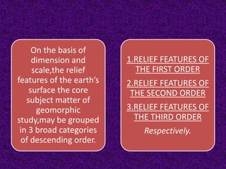
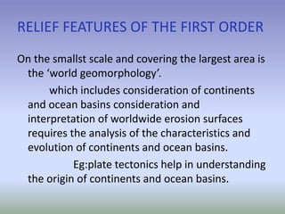
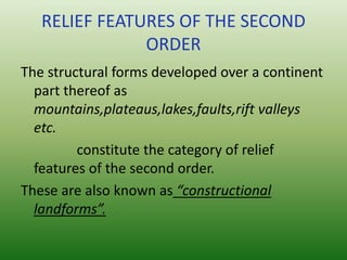
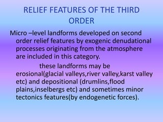
Geomorphology is the study of landforms and the processes that shape them. It is a branch of physical geography that analyzes relief features at different dimensions and scales. Relief features are organized into three orders based on size: first order includes continents and ocean basins shaped by plate tectics; second order consists of structural landforms like mountains and plateaus formed by constructional forces; third order comprises micro-level erosional and depositional landforms developed on second order features by exogenic processes like rivers and glaciers. Process geomorphology examines specialized subfields defined by the dominant shaping process, such as fluvial, glacial, coastal and karst landforms.
2. The rapidly evolving discipline of
geomorphology has undergone
seachange in methodology and
approaches to landforms and related
processes.
INTRODUCTION
3. MEANING:-
Geomorphology is significant branch of physical
geography(geomorphology,oceanography,clim
atology and biogeography).
The geomorphology stems
from three GREEK WORDS i.e. ‘ge’(meaning
earth), ‘morphe’(form) and ‘logos’(a
discourse).
4. DEFINITION
It is defined as the science of description of
various forms of the earth’s surface.
Geomorphology may be defined
as the systematic description and analysis of
landscapes and the processes that change
them.
-A.L.Bloom
5. SCOPE OF GEOMORPHOLOGY
The subject matter of
geomorphology may be
organised on the basis of
1.Dimension and scale of
relief features(landforms);
2.Processes that shape the
landforms and
3.The approaches to the
geomorphic studies.
6. Process geomorphology has evolved into
subfields of specializtion such as
hillscope morphology,fluvial
processes,karst,volcanic,arid,eolian,
glacial and coastal geomorphology-to
name only some of the better known.
7. To illustrate the concept of geomorphic
description in terms of structure,process,and
tme,consider the following two descriptive
paragraphs.
The first is empirical;it states what
and where;
The second is explanatory;it denotes how as
well as what and where.
8. On the basis of
dimension and
scale,the relief
features of the earth’s
surface the core
subject matter of
geomorphic
study,may be grouped
in 3 broad categories
of descending order.
1.RELIEF FEATURES OF
THE FIRST ORDER
2.RELIEF FEATURES OF
THE SECOND ORDER
3.RELIEF FEATURES OF
THE THIRD ORDER
Respectively.
9. RELIEF FEATURES OF THE FIRST ORDER
On the smallst scale and covering the largest area is
the ‘world geomorphology’.
which includes consideration of continents
and ocean basins consideration and
interpretation of worldwide erosion surfaces
requires the analysis of the characteristics and
evolution of continents and ocean basins.
Eg:plate tectonics help in understanding
the origin of continents and ocean basins.
10. RELIEF FEATURES OF THE SECOND
ORDER
The structural forms developed over a continent
part thereof as
mountains,plateaus,lakes,faults,rift valleys
etc.
constitute the category of relief
features of the second order.
These are also known as “constructional
landforms”.
11. RELIEF FEATURES OF THE THIRD
ORDER
Micro –level landforms developed on second
order relief features by exogenic denudational
processes originating from the atmosphere
are included in this category.
these landforms may be
erosional(glacial valleys,river valley,karst valley
etc) and depositional (drumlins,flood
plains,inselbergs etc) and sometimes minor
tectonics features(by endogenetic forces).