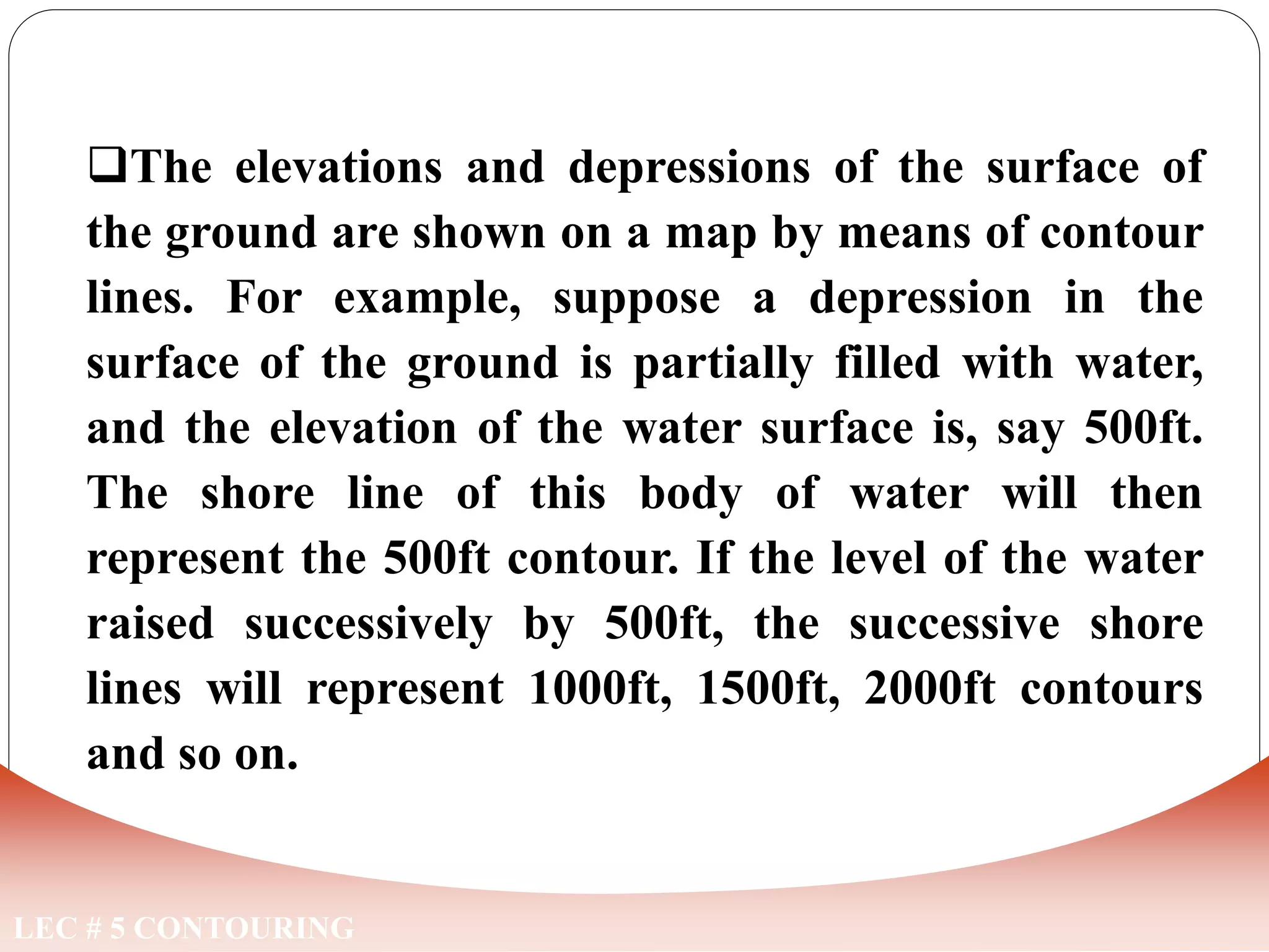
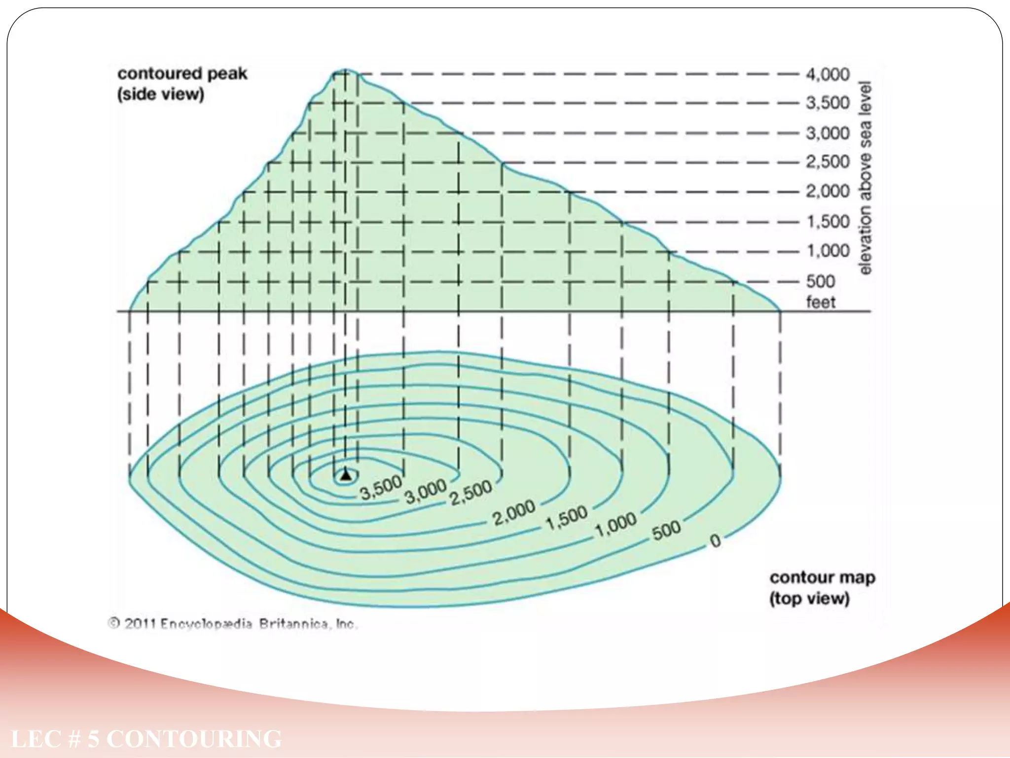
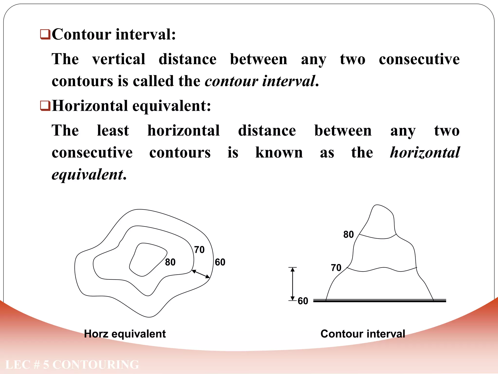
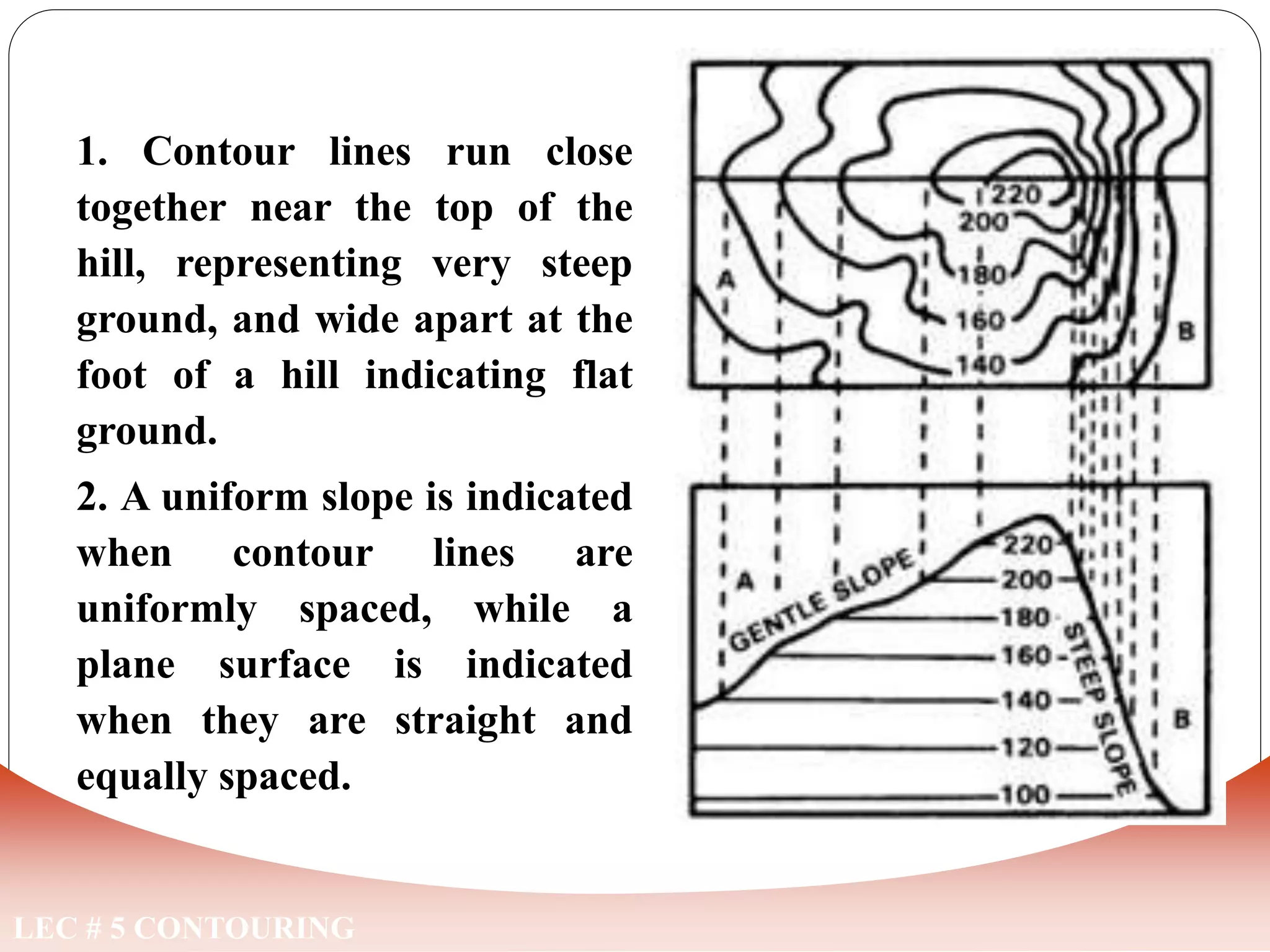
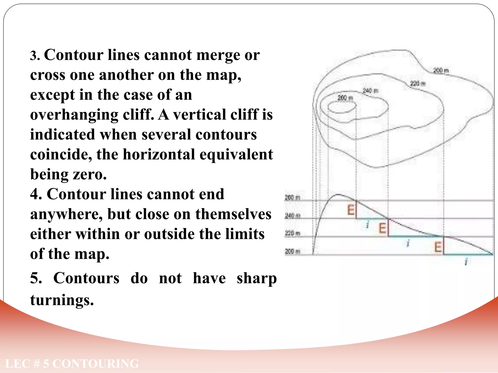
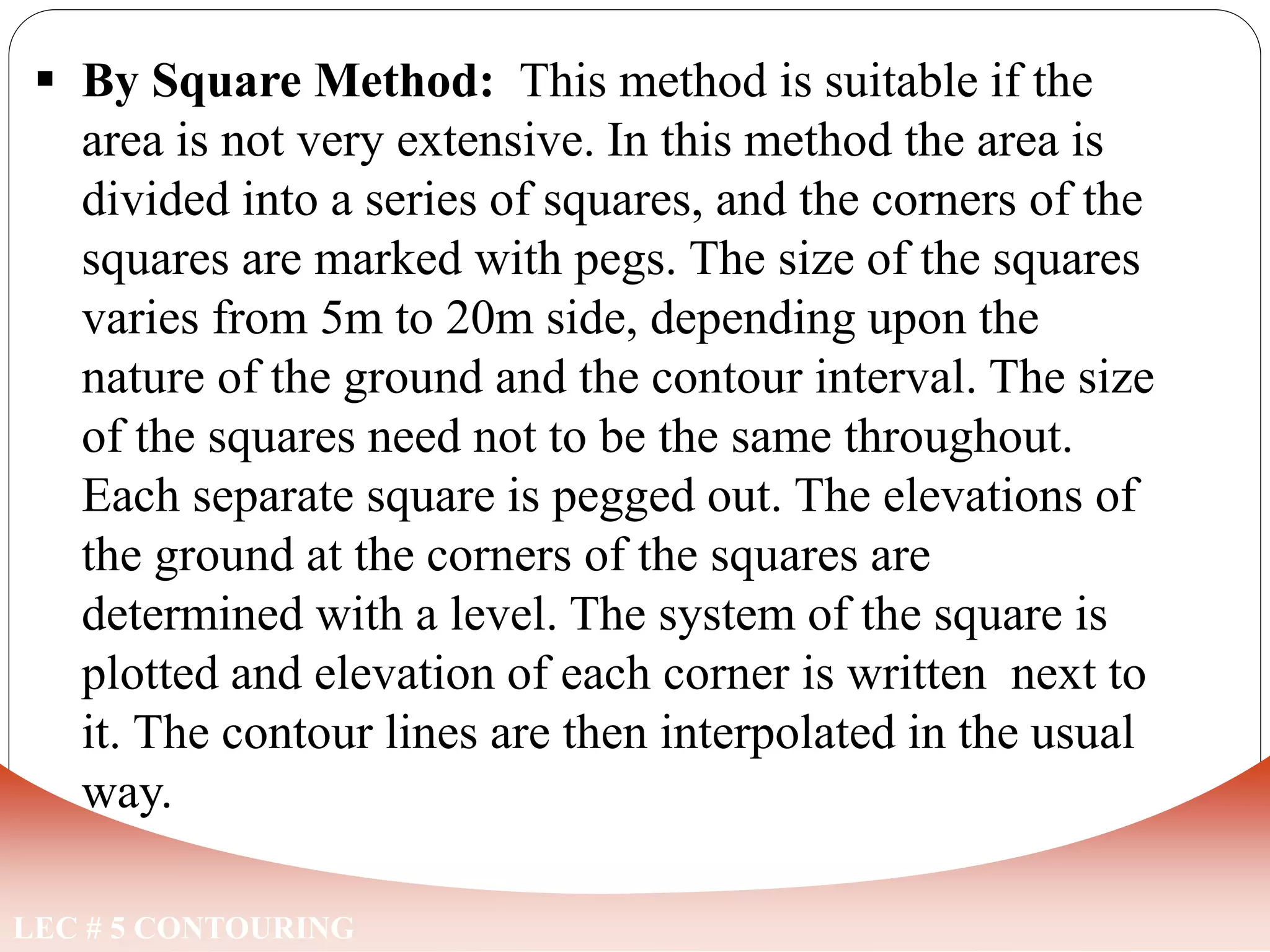
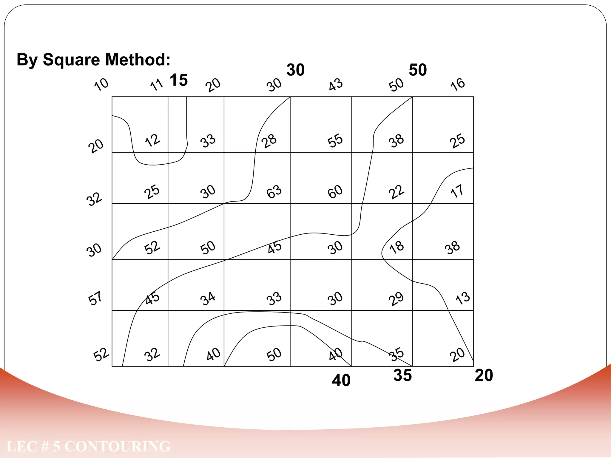
LEC # 5 CONTOURING
CONTOURING
CONTOUR
LEC # 5 CONTOURING
“An imaginary line on ground joining the points of equal
elevation above the assumed datum is called a contour”.
It is a plan projection of the plane passing through the
points of equal height on the surface of the Earth.
LEC # 5 CONTOURING
The elevations and depressions of the surface of
the ground are shown on a map by means of contour
lines. For example, suppose a depression in the
surface of the ground is partially filled with water,
and the elevation of the water surface is, say 500ft.
The shore line of this body of water will then
represent the 500ft contour. If the level of the water
raised successively by 500ft, the successive shore
lines will represent 1000ft, 1500ft, 2000ft contours
and so on.
CONTOUR
LEC # 5 CONTOURING
CONTOUR
Contour interval:
The vertical distance between any two consecutive
contours is called the contour interval.
Horizontal equivalent:
The least horizontal distance between any two
consecutive contours is known as the horizontal
equivalent.
LEC # 5 CONTOURING
Horz equivalent
60
70
80
60
70
80
Contour interval
LEC # 5 CONTOURING
For a given contour interval, the horizonal equivalent depends
upon the followings:-
a. Nature of the ground.
b. Purpose and extent of the survey.
c. Scale of the map.
d. Time and expense required in its determination.
FACTORS EFFECTING CONTOUR INTERVAL
LEC # 5 CONTOURING
Characteristics of Contour Lines
LEC # 5 CONTOURING
1. Contour lines run close
together near the top of the
hill, representing very steep
ground, and wide apart at the
foot of a hill indicating flat
ground.
2. A uniform slope is indicated
when contour lines are
uniformly spaced, while a
plane surface is indicated
when they are straight and
equally spaced.
CHARACTERISTICS OF CONTOUR LINES
LEC # 5 CONTOURING
3. Contour lines cannot merge or
cross one another on the map,
except in the case of an
overhanging cliff. A vertical cliff is
indicated when several contours
coincide, the horizontal equivalent
being zero.
4. Contour lines cannot end
anywhere, but close on themselves
either within or outside the limits
of the map.
5. Contours do not have sharp
turnings.
CHARACTERISTICS OF CONTOUR LINES
LEC # 5 CONTOURING
CHARACTERISTICS OF CONTOUR LINES
6. A series of closed contours on the map indicates a
pond/depression or a hill/summit, according as the lower or
higher values are inside them. Depressions between summits
are called saddles.
LEC # 5 CONTOURING
Use of CONTOURS
USES OF CONTOURS
LEC # 5 CONTOURING
1. By Inspection of a contour map, information regarding the general
character of the tract of the country is obtained, whether it is flat,
undulating or mountainous, etc.
2. The most economical or suitable site for engineering works such as
a reservoir, canal, sewer, road, or railway may be approximately
selected.
3. Quantities of earthwork may be computed from the contour maps.
4. Contours may be used to determine the area of the drainage basin
and the capacity of the reservoir.
5. The sections may be easily drawn in any direction from the
contours.
6. Intervisibility of two given points can be ascertained from the map.
7. A route of a given grade line can be traced on the map.
8. To decide the best positions of guns, the line of march and camping
grounds by the army commanders during wars.
LEC # 5 CONTOURING
Locating Contours
METHODS OF LOCATING CONTOURS
LEC # 5 CONTOURING
The various methods of locating contours may be classified as
follows:
1. Direct Method
2. Indirect Method
Direct Method:
In this method, contours to be plotted are actually traced out in
the field. This method is comparatively slow and is generally
not adopted on large surveys unless a superior accuracy is
demanded. It is suitable for contouring of small areas where
better accuracy is required.
LEC # 5 CONTOURING
B.M
R.L 500
1.52
HI=501.52
0.52
A
501
0.52
B
501
1.52
C
500
2.52
D
499
METHODS OF LOCATING CONTOURS
R.L=
R.L=
R.L=
R.L=
LEC # 5 CONTOURING
Contour Lines:
METHODS OF LOCATING CONTOURS
LEC # 5 CONTOURING
2. Indirect Methods:
Indirect method of contouring is commonly
employed in small scale surveys of extensive
areas. This method is cheaper, quicker and less
tedious as compared with direct method of
contouring. Indirect method of contouring can
be employed in three different ways detailed
below:
a. By Squares Method
b. By Cross Sections Method
c. By Radial Lines Method
METHODS OF LOCATING CONTOURS
LEC # 5 CONTOURING
 By Square Method: This method is suitable if the
area is not very extensive. In this method the area is
divided into a series of squares, and the corners of the
squares are marked with pegs. The size of the squares
varies from 5m to 20m side, depending upon the
nature of the ground and the contour interval. The size
of the squares need not to be the same throughout.
Each separate square is pegged out. The elevations of
the ground at the corners of the squares are
determined with a level. The system of the square is
plotted and elevation of each corner is written next to
it. The contour lines are then interpolated in the usual
way.
METHODS OF LOCATING CONTOURS
LEC # 5 CONTOURING
35
50
20
40
15
30
By Square Method:
METHODS OF LOCATING CONTOURS
LEC # 5 CONTOURING
 By Cross Section Method: This method is
most commonly used in a route surveys of a road,
railway or canal alignment. Cross-sections are run
transverse to the centre line of a road, railway, or
canal, and the points of change in slope are
located. The cross-section line may be inclined at
an angle to the centre line if necessary. The
spacing of the cross-sections depends upon the
character of the ground. It is usually 20m in a
hilly country, and 100m in a flat country. The
reduced levels of the various points along the
section lines are plotted on the plan and the
contours are then interpolated.
METHODS OF LOCATING CONTOURS
LEC # 5 CONTOURING
By Section Method:
A
B
METHODS OF LOCATING CONTOURS
510
520
530
540
LEC # 5 CONTOURING
 By Radiation Method: This method is
particularly suitable when a contoured map of
a hill is required. A number of lines are set out,
radiating at a given angular interval from each
of the traverse stations, and the representative
points on these lines are located in the field by
observing, (i) The horizontal distances, and (ii)
the Staff readings of the bottom, middle, and
top wire.
The elevations and the distances of these points
are then calculated. The survey is plotted and the
contour lines are then interpolated.
METHODS OF LOCATING CONTOURS
LEC # 5 CONTOURING
By Tachometric / Radiation Method:
B
A
816
853 846
844
832
817
828
833
816
829
838
835
826
816
840
836
832
828 815
METHODS OF LOCATING CONTOURS
LEC # 5 CONTOURING
COMPARISION
S.NO DIRECT METHOD INDIRECT METHOD
1 The method is accurate but very
slow & trouble some.
Not very accurate but
quicker.
2 It is very expensive It is very cheap
3 For small projects where greater
accuracy is require.
For larger project where
greater accuracy is not
require.
4 It is unsuitable for hilly areas. It is suitable for all type of
areas.
5 Calculation is to be done in the
field.
Calculation is not done in the
field.
COMPARISON
ASSIGNMENT
CONTOURING EXERCISE
A contouring exercise was carried out in NICE
AREA cricket ground by the method of SQUARS.
The observed Levels of the corners of the
SQUARES have been noted in their respective
locations.
You are required to draw the contours of the
area at an interval of one foot. The contours of
1830 and 1835 have been drawn for your
guidance.
Draw contour of 1828,1829,1830,1831,1832,1833,1834,1835,1836,1837
INDEX
CONTOUR
are 1830
and 1835
Draw contour of 1828,1829,1830,1831,1832,1833,1834,1835,1836,1837
INDEX
CONTOUR
are 1830
and 1835

Contouring Survey.ppt

  • 1.
    LEC # 5CONTOURING CONTOURING
  • 2.
    CONTOUR LEC # 5CONTOURING “An imaginary line on ground joining the points of equal elevation above the assumed datum is called a contour”. It is a plan projection of the plane passing through the points of equal height on the surface of the Earth.
  • 3.
    LEC # 5CONTOURING The elevations and depressions of the surface of the ground are shown on a map by means of contour lines. For example, suppose a depression in the surface of the ground is partially filled with water, and the elevation of the water surface is, say 500ft. The shore line of this body of water will then represent the 500ft contour. If the level of the water raised successively by 500ft, the successive shore lines will represent 1000ft, 1500ft, 2000ft contours and so on. CONTOUR
  • 4.
    LEC # 5CONTOURING CONTOUR
  • 5.
    Contour interval: The verticaldistance between any two consecutive contours is called the contour interval. Horizontal equivalent: The least horizontal distance between any two consecutive contours is known as the horizontal equivalent. LEC # 5 CONTOURING Horz equivalent 60 70 80 60 70 80 Contour interval
  • 6.
    LEC # 5CONTOURING For a given contour interval, the horizonal equivalent depends upon the followings:- a. Nature of the ground. b. Purpose and extent of the survey. c. Scale of the map. d. Time and expense required in its determination. FACTORS EFFECTING CONTOUR INTERVAL
  • 7.
    LEC # 5CONTOURING Characteristics of Contour Lines
  • 8.
    LEC # 5CONTOURING 1. Contour lines run close together near the top of the hill, representing very steep ground, and wide apart at the foot of a hill indicating flat ground. 2. A uniform slope is indicated when contour lines are uniformly spaced, while a plane surface is indicated when they are straight and equally spaced. CHARACTERISTICS OF CONTOUR LINES
  • 9.
    LEC # 5CONTOURING 3. Contour lines cannot merge or cross one another on the map, except in the case of an overhanging cliff. A vertical cliff is indicated when several contours coincide, the horizontal equivalent being zero. 4. Contour lines cannot end anywhere, but close on themselves either within or outside the limits of the map. 5. Contours do not have sharp turnings. CHARACTERISTICS OF CONTOUR LINES
  • 10.
    LEC # 5CONTOURING CHARACTERISTICS OF CONTOUR LINES 6. A series of closed contours on the map indicates a pond/depression or a hill/summit, according as the lower or higher values are inside them. Depressions between summits are called saddles.
  • 11.
    LEC # 5CONTOURING Use of CONTOURS
  • 12.
    USES OF CONTOURS LEC# 5 CONTOURING 1. By Inspection of a contour map, information regarding the general character of the tract of the country is obtained, whether it is flat, undulating or mountainous, etc. 2. The most economical or suitable site for engineering works such as a reservoir, canal, sewer, road, or railway may be approximately selected. 3. Quantities of earthwork may be computed from the contour maps. 4. Contours may be used to determine the area of the drainage basin and the capacity of the reservoir. 5. The sections may be easily drawn in any direction from the contours. 6. Intervisibility of two given points can be ascertained from the map. 7. A route of a given grade line can be traced on the map. 8. To decide the best positions of guns, the line of march and camping grounds by the army commanders during wars.
  • 13.
    LEC # 5CONTOURING Locating Contours
  • 14.
    METHODS OF LOCATINGCONTOURS LEC # 5 CONTOURING The various methods of locating contours may be classified as follows: 1. Direct Method 2. Indirect Method Direct Method: In this method, contours to be plotted are actually traced out in the field. This method is comparatively slow and is generally not adopted on large surveys unless a superior accuracy is demanded. It is suitable for contouring of small areas where better accuracy is required.
  • 15.
    LEC # 5CONTOURING B.M R.L 500 1.52 HI=501.52 0.52 A 501 0.52 B 501 1.52 C 500 2.52 D 499 METHODS OF LOCATING CONTOURS R.L= R.L= R.L= R.L=
  • 16.
    LEC # 5CONTOURING Contour Lines: METHODS OF LOCATING CONTOURS
  • 17.
    LEC # 5CONTOURING 2. Indirect Methods: Indirect method of contouring is commonly employed in small scale surveys of extensive areas. This method is cheaper, quicker and less tedious as compared with direct method of contouring. Indirect method of contouring can be employed in three different ways detailed below: a. By Squares Method b. By Cross Sections Method c. By Radial Lines Method METHODS OF LOCATING CONTOURS
  • 18.
    LEC # 5CONTOURING  By Square Method: This method is suitable if the area is not very extensive. In this method the area is divided into a series of squares, and the corners of the squares are marked with pegs. The size of the squares varies from 5m to 20m side, depending upon the nature of the ground and the contour interval. The size of the squares need not to be the same throughout. Each separate square is pegged out. The elevations of the ground at the corners of the squares are determined with a level. The system of the square is plotted and elevation of each corner is written next to it. The contour lines are then interpolated in the usual way. METHODS OF LOCATING CONTOURS
  • 19.
    LEC # 5CONTOURING 35 50 20 40 15 30 By Square Method: METHODS OF LOCATING CONTOURS
  • 20.
    LEC # 5CONTOURING  By Cross Section Method: This method is most commonly used in a route surveys of a road, railway or canal alignment. Cross-sections are run transverse to the centre line of a road, railway, or canal, and the points of change in slope are located. The cross-section line may be inclined at an angle to the centre line if necessary. The spacing of the cross-sections depends upon the character of the ground. It is usually 20m in a hilly country, and 100m in a flat country. The reduced levels of the various points along the section lines are plotted on the plan and the contours are then interpolated. METHODS OF LOCATING CONTOURS
  • 21.
    LEC # 5CONTOURING By Section Method: A B METHODS OF LOCATING CONTOURS 510 520 530 540
  • 22.
    LEC # 5CONTOURING  By Radiation Method: This method is particularly suitable when a contoured map of a hill is required. A number of lines are set out, radiating at a given angular interval from each of the traverse stations, and the representative points on these lines are located in the field by observing, (i) The horizontal distances, and (ii) the Staff readings of the bottom, middle, and top wire. The elevations and the distances of these points are then calculated. The survey is plotted and the contour lines are then interpolated. METHODS OF LOCATING CONTOURS
  • 23.
    LEC # 5CONTOURING By Tachometric / Radiation Method: B A 816 853 846 844 832 817 828 833 816 829 838 835 826 816 840 836 832 828 815 METHODS OF LOCATING CONTOURS
  • 24.
    LEC # 5CONTOURING COMPARISION S.NO DIRECT METHOD INDIRECT METHOD 1 The method is accurate but very slow & trouble some. Not very accurate but quicker. 2 It is very expensive It is very cheap 3 For small projects where greater accuracy is require. For larger project where greater accuracy is not require. 4 It is unsuitable for hilly areas. It is suitable for all type of areas. 5 Calculation is to be done in the field. Calculation is not done in the field. COMPARISON
  • 25.
    ASSIGNMENT CONTOURING EXERCISE A contouringexercise was carried out in NICE AREA cricket ground by the method of SQUARS. The observed Levels of the corners of the SQUARES have been noted in their respective locations. You are required to draw the contours of the area at an interval of one foot. The contours of 1830 and 1835 have been drawn for your guidance.
  • 26.
    Draw contour of1828,1829,1830,1831,1832,1833,1834,1835,1836,1837 INDEX CONTOUR are 1830 and 1835
  • 27.
    Draw contour of1828,1829,1830,1831,1832,1833,1834,1835,1836,1837 INDEX CONTOUR are 1830 and 1835