SlideShare a Scribd company logo
Proceedings of the International Conference on Emerging Trends in Engineering and Management (ICETEM14)
30 – 31, December 2014, Ernakulam, India
211
SEDIMENT FLOW CHANGES INDUCED BY DAMS IN
PAMBA RIVER
AJITH A.V.,
Associate Professor in Civil, SNGCE Kadayiruppu, Kolencherry, Ernakulam Dist. Kerala
Dr. ABDU REHMAN K.U.,
Associate Professor, School of Engineering, Cusat
ABSTRACT
The Pamaba River is the third longest river in Kerala after Periyar and Bharathappuza. The length of the river is
176 Km .The total catchment area of river basin is 2235 km2
.
The Pamba river and its tributaries have eleven dams which are constructed mainly for Hydroelectric projects
and Water Supply and Irrigation projects such as “Sabarigiri”, “Kakkad”, “Maniyar”, and” Pamba irrigation project”.
Many of these dams are constructed in different periods. The dams have significant effects in the flow of sediments
through the rivers. The effect of dams on sediment flow is studied by analyzing the sediment load data and discharge
load data from three gauging stations such as Kalooppara, Thumpamon and Malakkara. These data are collected from
Central Water Commission. The data during Monsoon season, for six months, from June to November is analysied from
the beginning to till date. Yearly data from these three stations were also compared to study the variation of sediment
load with discharge and the gradual change in sediment flow rate.
Keywords: Dam, Discharge Load, Pamba River, Run Off, Sediment Flow, Sediment Load.
1. INTRODUCTION
Sediment transport in rivers is associated with a wide variety of environmental and engineering issues. Effective
management of sediment in rivers is becoming increasingly important from an economic, social and environmental
perspective. Adverse impacts of increased sediment deposition can result in increased flooding and resulting property
damage, contamination of water supplies, loss of crops, social dislocation and temporary homelessness, and even loss of
life.
Natural river reaches are usually in a state of morphological equilibrium, where the sediment inflow on average
balances the sediment outflow. Reservoirs can upset this equilibrium by slowing or halting the movement of water and
allowing sediment to settle, thereby preventing the movement of sediment downstream. This is an important issue for
many rivers around the world.
Soil erosion in the upstream river basins, its transport, and deposition play a major role in understanding many
activities of global significance. The recent activities of man in changing river courses and construction of dams across
natural rivers have significantly altered the sediment yield regime. In estuarine and coastal zones, which are major sinks
of sediment, alteration of the natural sediment supply can cause considerable changes in ecosystem propagation.
INTERNATIONAL JOURNAL OF CIVIL ENGINEERING AND
TECHNOLOGY (IJCIET)
ISSN 0976 – 6308 (Print)
ISSN 0976 – 6316(Online)
Volume 5, Issue 12, December (2014), pp. 211-218
© IAEME: www.iaeme.com/Ijciet.asp
Journal Impact Factor (2014): 7.9290 (Calculated by GISI)
www.jifactor.com
IJCIET
©IAEME
Proceedings of the International Conference on Emerging Trends in Engineering and Management (ICETEM14)
30 – 31, December 2014, Ernakulam, India
212
Sediment transport from northern rivers is highly influenced by the SW monsoon, whereas both the southwest and
northeast monsoons control the sediment yield of southern rivers. About 90 - 95 % of the sediment load is carried by the
monsoon river flows and few particular days in monsoon supplies bulk of the annual sediment load transported by the
rivers.
Pamba River is selected as the representative hydrologic regime for detailed studies about the sediment flow
changes that is caused by the construction of dams.
2. PAMBA RIVER
Kerala is the land of rivers and backwaters. There are 44 rivers cut across Kerala with its innumerable tributaries
and branches.The Pamaba river is the third longest river in Kerala after Periyar and Bharathappuza.
Pamba originates at Pulachimalai hill in the Peerumedu plateau in the Western Ghats at an altitude of 1650
meters and flows through Ranni,Kozenchery, Thiruvalla, Chenganoor,Kuttanadu, Karthikappally and Ambalappuza
Taluk and finally empties in to the Vembanadu lake. The river shares its northern boundary with the Manimala
river basin, while it shares the southern boundary with the Achankovil River basin. Pamba has many rivers combining it
starting from Kakkiyar, Azhuthayar, Kakkatar and Kallar all its tributaries. The length of the river is 176 Km. The total
catchment area of river basin is 2235 km2
. The basin experiences good rainfall, moderate temperature and humid
atmosphere. The SW and NE monsoon have great influence over the climatic condition. The normal daily temperature
varies from 22.60
C to 32.70
C as per IMD. Average annual rainfall varies from 2276 mm to 4275 mm.
The Pamba is considered as the Dakshina Ganga (Southern Ganges) due to its association with Kerala's Largest
Pilgrim Centre - Sabarimala.
2.1. TRIBUTRIES OF PAMBA RIVER
The following are the tributaries of Pamba River.
1. Azuthayar.
2. Kakkiyar
3. Kakkatar
4. Kallar
5. Perunthenaruvi
6. Madatharuvi
7. Thanugattilthodu
8. Kozithodu9. Varattar
10. Kuttemperoor.
2.2. SALIENT FEATURES OF PAMBA RIVER
Location: Latitude: 090
-24’. Longitude: 770
-10’E
Basin Area: 2235km2
.Length of main stream: 176 Km
Origin of river: Pullichimala
Average annual rainfall: 3600mm
2.3. DAM
A dam is a hydraulic structure constructed across a river to store water on the upstream side. It is an impervious
or fairly impervious barrier put across a natural stream so that the reservoir is formed. Due to the construction of dams
water level in the river at its up-stream side is very much increased and a large area may be submerged depending up on
the water spread of the reservoir so formed.
2.4. DAMS IN PAMBA RIVER
Kakki dam, Anathodu dam, Pamba dam, Gavi dam, Kallar dam, Mooziyar dam, Upper mooziyar dam,
Meenar 1, Meenar 2, Veluthodu (Kakkad) dam, Maniyar dam.`
Proceedings of the International Conference on Emerging Trends in Engineering and Management (ICETEM14)
30 – 31, December 2014, Ernakulam, India
213
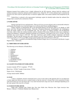
Pamba River
3. SEDIMENTS
Sediment is defined as fragmented material formed by physical and chemical weathering of rocks. Sediment
(sometimes called “silt” or “alluvium”) is comprised of solid particles of mineral and organic material that are
transported by water. In river systems the amount of sediment transported is controlled by both the transport capacity of
the flow and the supply of sediment
Sediment transport study includes movement of huge boulders down mountain sides, to diffusion of colloid-sized
material in groundwater systems. Transport is driven by gravity, and drag forces between the sediment and surrounding
fluid (air or water).
3.1. CLASSIFICATION OF SEDIMENTS
Sediment can be classified as 1. Deposited sediments, 2. Suspended sediments.
Deposited sediment is that found on the bed of a river or lake.
The “suspended sediment load” refers to the fine sediment that is carried in suspension and this can comprise
material picked up from the bed of the river (suspended bed material) and material washed into the river from the
surrounding land (wash load). The wash load is usually finer than the suspended bed material. In contrast, the “bed load”
comprises larger sediment particles that are transported on the bed of the river by rolling, sliding or saltation.
Suspended sediment is found in the water column where it is being transported by water movements.
Most rivers will transport sediment in each of these “load” forms, according to the flow conditions. Suspended sediment
is also referred to as suspended matter, particulate matter or suspended solids. Generally, the term suspended solids refers
to mineral + organic solids, whereas suspended sediment should be restricted to the mineral fraction of the suspended
solids load.
3.2. TYPES OF SEDIMENT TRANSPORT
Sediment transport is a direct function of water movement. During transport in a water body, sediment particles become
separated into three categories:
3.2.1. (1) Suspended material
Suspended materials include silt + clay + sand; the coarser, relatively inactive bedload and the saltation load.
Suspended load comprises sand + silt + clay-sized particles that are held in suspension because of the turbulence of the
water.
The suspended load is further divided into the wash load.
Wash load is generally considered to be the silt + clay-sized material (< 62 µm in particle diameter) and is often
referred to as “fine-grained sediment”. The wash load is mainly controlled by the supply of this material (usually by
means of erosion) to the river.
The amount of sand (>62 µm in particle size) in the suspended load is directly proportional to the turbulence and
mainly originates from erosion of the bed and banks of the river. In many rivers, suspended sediment (i.e. the mineral
fraction) forms most of the transported load.
Proceedings of the International Conference on Emerging Trends in Engineering and Management (ICETEM14)
30 – 31, December 2014, Ernakulam, India
214
3.2.2. (2) Bed load
Bed load is stony material, such as gravel and cobbles that moves by rolling along the bed of a river because it is
too heavy to be lifted into suspension by the current of the river. Bed load is especially important during periods of
extremely high discharge and in landscapes of large topographical relief, where the river gradient is steep (such as in
mountains). It is rarely important in low-lying areas.
Measurement of bed load is extremely difficult. Most bed load movement occurs during periods of high
discharge on steep gradients when the water level is high and the flow is extremely turbulent. Such conditions also cause
problems when making field measurements
3.2.3. (3) Saltation load
Saltation load is a term used by sedimentologists to describe material that is transitional between bedload and
suspended load. Saltation means “bouncing” and refers to particles that are light enough to be picked off the river bed by
turbulence but too heavy to remain in suspension and, therefore, sink back to the river bed. Saltation load is never
measured in operational hydrology.
4. FACTORSAFFECTINGRIVER’SVELOCITY
A river's velocity refers to the speed at which a river moves water through its channel. The velocity of a river is
determined by many factors, including the shape of its channel, the gradient of the slope that the river mover along, the
volume of water that the river carries and the amount of friction caused by rough edges within the riverbed.
4.1. CHANNEL SHAPE
The shape of the channel affects the velocity of a river. Around the perimeter of the river, at the sides and along
the river bed friction is created as water flows against the edges. Water flowing through a wide, deep river channel
encounters less resistance than water flowing in a narrow, shallow channel, since a smaller proportion of the total water
molecules will be slowed by the river's edges. The center of the river experiences the greatest velocity.
4.2. VOLUME
The volume of water that flows through a river within a given amount of time -- also known as the discharge --
also affects its velocity. As the volume of water in a river increases, through smaller streams flowing into it, for example,
the velocity of the river increases. An increase in water volume can also affect a river's velocity in the long term; this is
because the increasing mass of water is capable of causing more erosion, resulting in a wider, deeper river channel that
allows water to flow more freely.
4. 3. SMOOTH AND ROUGH CHANNEL
Rough river channels are those which contain a large quantity of rocks, pebbles and boulders, either at the
bottom of the river or embedded within its sides. A great deal of friction is created between water molecules and these
stones as the river flows past them; in rough channels, the resistance caused by this friction reduces the river's velocity.
In a smooth river channel, with fewer pebbles and rocks, velocity is higher as there is less friction causing energy to be
expended as it flows.
4.4. GRADIENT
The gradient of a river refers to how steep its slope is; this also has a significant effect on the velocity of a river.
When a river flows down a steep slope, the gravitational force that pulls the water downwards is stronger than it would
be on water flowing down a gentle slope, resulting in the river having a greater level of velocity.
The velocity of the flowing waters of a nearby river depends on local rainfall amounts and elevation. Scientists and
engineers define velocity as how fast an object's position changes as time passes. An object moving in a straight line, in a
river for example, has velocity equal to the distance it moves divided by the time of travel of that object. A common unit
for velocity is feet per second. By using a few tools we can calculate the velocity of a river.
5. RAINFALL IN KERALA
The major rainfall season in Kerala is from June to October (Monsoon Period).
The Kerala State, situated in the humid tropics lies between 8° 18’ and 12° 48’ N and 74° 52’ and 77° 22’ E.
Based on the topography, the state can be divided into three well-defined natural landforms: the lowlands with altitude
less than 7.5 m; midlands with altitude between 7.5 and 75m; and the highlands with altitudes greater than 75 m. The
state is a narrow strip of land with width varying from 30 km in the north and south to about 130 km in the central
region. The Western Ghats forms a continuous mountain wall on the eastern border of the state while Arabian Sea is the
margin to west.
Proceedings of the International Conference on Emerging Trends in Engineering and Management (ICETEM14)
30 – 31, December 2014, Ernakulam, India
215
5.1. MONSOON PERIOD (JUNE TO OCTOBER)
A major part of India (Excluding Jammu and Kashmir and South Eastern parts) gets more than 75% of rainfall
due to monsoon winds which originate in the Indian Ocean and proceed to the sub continent. The monsoon wind
advancing from south – western direction breaks up in to two distinct branches.
Bay of Bengal branch, Arabian Sea branch.
The Arabian Sea branch touches Kerala while the Bay of Bengal branch reaches the North – Eastern states of
India.
The average annual rainfall for the State is about 3000 mm. It ranges in the lowland, from 900 mm in the south
to 3500 mm in the north; in the midland, from 1400 mm to 4000mm; and in the highland, from 2500 mm to 6000 mm
(CWRDM, 1995). About 65 % of this rainfall is received during the southwest (SW) monsoon and 25 % during northeast
(NE) monsoon. However, for the southern parts, NE monsoon is active compared to the northern Kerala.
6. INFILTRATION
Infiltration may be defined as the downward movement of water from soil surface in to the soil mass .When rain
water falls on the ground, a small part of it is initially absorbed by the top thin layer of soil so as to replenish the soil –
moisture deficiency, and thereafter, excess water infiltrates downwards to join ground water. So infiltration is the entry
of water in to the soil through soil surface. Once water enters in to the soil, the process of transmission of water in to the
soil, known as percolation takes place thus removing the water from near the surface to down below.
6.1. FACTORS AFFECTING INFILTRATION
1. Condition of entry surface: Vegetation cover verses bare land
2. Permeability/Percolation characteristics of soil formation
3. Temperature.
4. Intensity and duration of rain fall
5. Movement of men and animals.
6. Change due to human activity
7. Quality of water
8. Presence of ground water table
7. RUN – OFF
The term “run – off “ is used for water that is on the “run” or in a flowing state in contrast to the water held in
depression storage and water evaporated in the atmosphere. The run off of a catchment area in any specified period is the
total quantity of water draining in to the stream or in to a reservoir in that period. This can be expressed as in centimeters
of water over a catchment or the total water in cubic meters or Hectare – meter for a given catchment. Run-off is broadly
classified in to three types. They are
1. Surface run-off
2. Sub surface run-off
3. Base flow.
8. DAM CONSTRUCTION
The construction of dams and other hydraulic structures is one of the oldest branches of engineering. Dams and
diversions are constructed and operated for a wide variety of purposes including residential, commercial, and agricultural
water supply; flood and/or debris control; and hydropower production. Regardless of their purpose, all dams trap
sediment to some degree and most alter the flood peaks and seasonal distribution of flows, thereby profoundly changing
the character and functioning of rivers. By changing flow regime and sediment load, dams can produce adjustments in
alluvial channels, the nature of which depends upon the characteristics of the original and altered flow regimes and
sediment loads.
9. ANALYSIS
The Discharge data and sediment load data from three gauging station of Central Water commission were
analyzed. The gauging stations are Kalloppara, Malakkara and Thumpamon. Out of these three, Kalloppara is the
gauging station nearer to Vembanadu lake. Then comes Malakkara and Thumbamon.
Proceedings of the International Conference on Emerging Trends in Engineering and Management (ICETEM14)
30 – 31, December 2014, Ernakulam, India
216
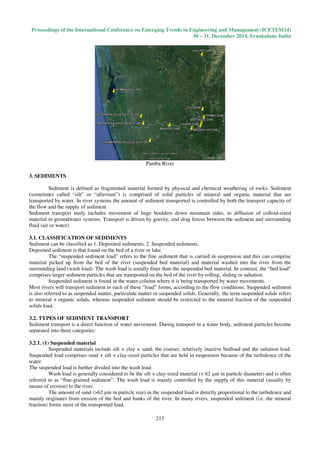
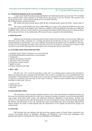
The data from Kallooppara gauging station were analyzed first. Starting from the year 1986 for Monsoon season
i.e. from June to November, the data were considered up to 2010. At first the data for each month in monsoon season for
the year 1986 were analyzed. It was found that the sediment load is more in June as the discharge increase. But the
sediment load was decreased for the month of August even though the discharge is more than in June. The reason is that
as the rain fall decreases the surface run off from the catchment area of river will decrease. But there will be base flow
which is the water that percolates down through the surface soil. The base flow will be free of sediment.
JUNE 87 –NOV 87 (Kalooppara)
But during the month of October there will be heavy rainfall which will again increase the surface runoff and
hence increase of sediment load. Then gradually the discharge and sediment load decreases as the rainfall intensity
decreases.
This is the general flow condition up to the year 2010.But the main change noted was that, there is considerable
decrease in sediment load. The rate of decrease of sediment load is more when the data analysied at an interval of four
years. I.e. after considering the data in 1992 the data checked for the year 1996. Then the change in sediment load was
considerable.
For example, for a discharge value of 300 cumec the sediment load in the year 1986 for the month of June was
0.045tons/m3
. In August it became 0.035tons/m3
. Again it increased in September to a value of 0.065tons/m3
then in
November it became 0.03tons/m3.
These values were almost same up to the year 1992. But for the year 2010 it became
0.03 tons/m3
. We can see that the quantity of sediment decreased as the years passed.
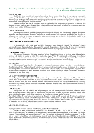
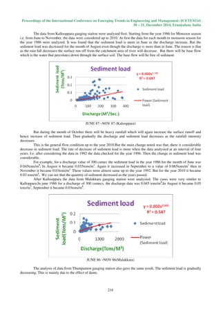
After Kallooppara the data from Malakkara gauging station were analysied. The cases were very similer to
Kalloppara.In june 1986 for a discharge of 300 cumecs, the discharge data was 0.045 tons/m3
.In August it became 0.05
tons/m3
, September it became 0.03tons/m3
.
JUNE 86 –NOV 86(Malakkara)
The analysis of data from Thumpamon gauging station also gave the same result. The sediment load is gradually
decreasing. This is mainly due to the effect of dams.
Proceedings of the International Conference on Emerging Trends in Engineering and Management (ICETEM14)
30 – 31, December 2014, Ernakulam, India
217
JUNE 86 –NOV 86 (Thumpamon)
But we can find that as the river crosses Kallooppara gauging station the sediment load is increasing than at
Malakkara and Thumpamon. The reason is that for any river there will be catchment area. The water reaching to the river
from the catchment area through small streams. The runoff from the catchment area will catch the loose soil particles as
sediment.
10. CONCLUSION
The effect of dams on sediment flow through rivers were studied by selecting Pamba river, using the discharge
data and sediment load data which were collected from three gauging stations namely Kallooppara, Thumpamon, and
Malakkara of Central Water commission.
This project verified how the quantity is varying after the construction of dams in this river. Considering the
year of starting of construction of dams in this river and in its tributaries, and also the year of completion of these dams
the sediment load data and discharge data were analysied graphically.
Starting from the year 1986 to 2010 the data were analyzed for the monsoon season (From June to November).
It was found that during the month of June the sediment load and discharge were more, but for the month of August
discharge was more but there was decrease in sediment load. The reason is that in August the rainfall intensity will be
less, so the surface run off will be less hence the sediment flow will be less. But there will be base flow which will
increase the discharge rate. Usually base flow will be free of sediments.
Again there was increase in discharge load as the intensity of rainfall increased hence there was increase in
sediment load also. During the month of November both discharge and sediment load were decreasing.
This is the general condition of flow. But it was found that the sediment load quantity is gradually decreasing as
years pass. When the data analyses for the year of 2010, there was about 50% reduction in sediment load than for the
year of 1986. This is mainly due to the effect of dams in this river and in its tributaries.
Out of the three gauging stations of Central Water Commission, the first one is Thumpamon. Then comes
Malakkara, and Kallooppara is nearer to Vembanadu lake. On analyzing the data graphically it was found that even
though there was decrease in sediment load quantity with years the sediment load is increasing when the flow reaching
Kallooppara gauging station. This shows that from the catchment area in that region the sediment load is more with
runoff. This may be due to the soil conditions, topography of that location, construction activities etc. In Thumpamon
more than 50% area is covered by forest. So the sediment load quantity will be less. Almost similar condition was
observed at Malakkara also. But the sediment load is more at Kallooppara. In this condition also we can observe that
there is reduction in sediment load quantity. This is mainly due to the effect of dams. Since there was a change in
sediment load observed at Kalkoppara there is scope of further study that what the causes of increasing sediment load
there are and even though there is increase in sediment load a common reduction can be observed. It also arising the need
of further experimental study during monsoon season in the catchment area.
11. REFERENCES
[1] Abbas, N. & Subramanian, V. (1984) Erosion and sediment transport in the Ganges River basin, India. J.
Hydrol. 69, 173-182.
[2] Central Water Commission, 1986-2010. Suspended Sediment Load Data and Discharge data of Pamba River
[3] Chakrapani G. J. & Subramanian V. (1993) Rates of erosion and sedimentation in the Mahanadi River basin,
India. J. Hydrol. 149, 39-48.
[4] Chandramohan T, Modeling of suspended sediment dynamics, PhD Thesis Cochin University of Science and
Technology.
[5] Dr. B.C. Punmia, Dr. Pande B.B. Lal,Irrigation and water power Engineering Laxmi Publications(P) Ltd New
Delhi Vol I P 346-526.
Proceedings of the International Conference on Emerging Trends in Engineering and Management (ICETEM14)
30 – 31, December 2014, Ernakulam, India
218
[6] Allan, J.D1995 Channels and Flow, the transport of materials, Chapman and hall publishing London P 8-1.
[7] Sameh.A.Kantoush Tetsuya Sumi, Akira kubota, Takamasa Suzuki,(2010) Impact of replenishment Below
Dams on flow and Bed morphology of rivers,Conference on Coastal zone managementof River deltas and low
land coast lines P 285 -290.
[8] Kerala State Electricity Board, Research Divisin, Details of Dams owned by KSEB.
[9] SUBRAMANIAN, (1996) The sediment load of Indian rivers - an update(Erosion and Sediment Yield: Global
and Regional Perspectives (Proceedings of the Exeter Symposium, July 1996) IAHS Publ. no. 236, 1996.
[10] Ahmed Shehab Al-Banna, Dhahir Khalil Ali and Hamed Hassan Abdullah, “Characteristics of Some
Geotechnical Properties of Pila SPI and Injana Sedimentary Formations, At Shaqlawa Area, North Iraq”,
International Journal of Civil Engineering & Technology (IJCIET), Volume 4, Issue 6, 2013, pp. 252 - 260,
ISSN Print: 0976 – 6308, ISSN Online: 0976 – 6316.

More Related Content

What's hot

Impact of Climate Change on Groundwater Resources
Impact of Climate Change on Groundwater ResourcesImpact of Climate Change on Groundwater Resources
Impact of Climate Change on Groundwater ResourcesC. P. Kumar
 
Using Computer-simulated hydrological model (SWAT) to estimate the ground-wat...
Using Computer-simulated hydrological model (SWAT) to estimate the ground-wat...Using Computer-simulated hydrological model (SWAT) to estimate the ground-wat...
Using Computer-simulated hydrological model (SWAT) to estimate the ground-wat...
Dhiraj Jhunjhunwala
 
Stream flow measurement technique
Stream flow measurement techniqueStream flow measurement technique
Stream flow measurement technique
Chandra Vanshi Thakur
 
Stream flow
Stream flow Stream flow
Stream flow
Meesum Zaidi
 
1 introduction to hydrology
1   introduction to hydrology1   introduction to hydrology
1 introduction to hydrology
AboutHydrology Slides
 
Hec ras
Hec rasHec ras
Hec ras
Karan Tyagi
 
Hydrology introduction ( catchment area)
Hydrology introduction ( catchment area)Hydrology introduction ( catchment area)
Hydrology introduction ( catchment area)
Latif Hyder Wadho
 
Storage and distribution reservoirs
Storage and distribution reservoirsStorage and distribution reservoirs
Storage and distribution reservoirs
farooq husain
 
Weirs on Permeable Foundations
Weirs on Permeable FoundationsWeirs on Permeable Foundations
Weirs on Permeable Foundations
Malla Reddy University
 
Flood routing
Flood routingFlood routing
Flood routing
vivek gami
 
Indus River Basin: Common Concerns and the Roadmap to Resolution
Indus River Basin: Common Concerns and the Roadmap to ResolutionIndus River Basin: Common Concerns and the Roadmap to Resolution
Indus River Basin: Common Concerns and the Roadmap to Resolution
Shakil Romshoo
 
RESERVOIR SEDIMENTATION
RESERVOIR SEDIMENTATIONRESERVOIR SEDIMENTATION
RESERVOIR SEDIMENTATION
LaxmanBhoyewar
 
4. Spillways.ppt
4. Spillways.ppt4. Spillways.ppt
4. Spillways.ppt
hussenbelew
 
Flood estimation
Flood estimation Flood estimation
Flood estimation
RAJ BAIRWA
 
Unit hydrograph
Unit hydrographUnit hydrograph
Unit hydrograph
Satish Taji
 
L8 unit hydrograph
L8 unit hydrographL8 unit hydrograph
L8 unit hydrograph
MEHEDIMASUM2
 
Flood frequency analysis
Flood frequency analysisFlood frequency analysis
Flood frequency analysis
Sanjan Banerjee
 
Runoff & Flood Frequency Analysis
Runoff & Flood Frequency AnalysisRunoff & Flood Frequency Analysis
Runoff & Flood Frequency Analysis
Malla Reddy University
 
Flood frequency analyses
Flood frequency analysesFlood frequency analyses
Flood frequency analyses
vivek gami
 
Analysis of runoff for vishwamitri river watershed using scs cn method and ge...
Analysis of runoff for vishwamitri river watershed using scs cn method and ge...Analysis of runoff for vishwamitri river watershed using scs cn method and ge...
Analysis of runoff for vishwamitri river watershed using scs cn method and ge...
vishvam Pancholi
 

What's hot (20)

Impact of Climate Change on Groundwater Resources
Impact of Climate Change on Groundwater ResourcesImpact of Climate Change on Groundwater Resources
Impact of Climate Change on Groundwater Resources
 
Using Computer-simulated hydrological model (SWAT) to estimate the ground-wat...
Using Computer-simulated hydrological model (SWAT) to estimate the ground-wat...Using Computer-simulated hydrological model (SWAT) to estimate the ground-wat...
Using Computer-simulated hydrological model (SWAT) to estimate the ground-wat...
 
Stream flow measurement technique
Stream flow measurement techniqueStream flow measurement technique
Stream flow measurement technique
 
Stream flow
Stream flow Stream flow
Stream flow
 
1 introduction to hydrology
1   introduction to hydrology1   introduction to hydrology
1 introduction to hydrology
 
Hec ras
Hec rasHec ras
Hec ras
 
Hydrology introduction ( catchment area)
Hydrology introduction ( catchment area)Hydrology introduction ( catchment area)
Hydrology introduction ( catchment area)
 
Storage and distribution reservoirs
Storage and distribution reservoirsStorage and distribution reservoirs
Storage and distribution reservoirs
 
Weirs on Permeable Foundations
Weirs on Permeable FoundationsWeirs on Permeable Foundations
Weirs on Permeable Foundations
 
Flood routing
Flood routingFlood routing
Flood routing
 
Indus River Basin: Common Concerns and the Roadmap to Resolution
Indus River Basin: Common Concerns and the Roadmap to ResolutionIndus River Basin: Common Concerns and the Roadmap to Resolution
Indus River Basin: Common Concerns and the Roadmap to Resolution
 
RESERVOIR SEDIMENTATION
RESERVOIR SEDIMENTATIONRESERVOIR SEDIMENTATION
RESERVOIR SEDIMENTATION
 
4. Spillways.ppt
4. Spillways.ppt4. Spillways.ppt
4. Spillways.ppt
 
Flood estimation
Flood estimation Flood estimation
Flood estimation
 
Unit hydrograph
Unit hydrographUnit hydrograph
Unit hydrograph
 
L8 unit hydrograph
L8 unit hydrographL8 unit hydrograph
L8 unit hydrograph
 
Flood frequency analysis
Flood frequency analysisFlood frequency analysis
Flood frequency analysis
 
Runoff & Flood Frequency Analysis
Runoff & Flood Frequency AnalysisRunoff & Flood Frequency Analysis
Runoff & Flood Frequency Analysis
 
Flood frequency analyses
Flood frequency analysesFlood frequency analyses
Flood frequency analyses
 
Analysis of runoff for vishwamitri river watershed using scs cn method and ge...
Analysis of runoff for vishwamitri river watershed using scs cn method and ge...Analysis of runoff for vishwamitri river watershed using scs cn method and ge...
Analysis of runoff for vishwamitri river watershed using scs cn method and ge...
 

Viewers also liked

Environmental Qualitative assessment of rivers sediments
Environmental Qualitative assessment of rivers sedimentsEnvironmental Qualitative assessment of rivers sediments
Environmental Qualitative assessment of rivers sediments
GJESM Publication
 
Rivers are more_than_water
Rivers are more_than_waterRivers are more_than_water
Rivers are more_than_waterriaenglish
 
Evaluating best management practices for decreasing downstream sediment load ...
Evaluating best management practices for decreasing downstream sediment load ...Evaluating best management practices for decreasing downstream sediment load ...
Evaluating best management practices for decreasing downstream sediment load ...
International Water Management Institute (IWMI)
 
Dam removal sediment transport using hecras
Dam removal sediment transport using hecrasDam removal sediment transport using hecras
Dam removal sediment transport using hecrasBishes Rayamajhi
 
HECRAS Bridge Scour Analysis
HECRAS Bridge Scour AnalysisHECRAS Bridge Scour Analysis
HECRAS Bridge Scour Analysis
Christopher L Chatfield, P.E.
 
03 Sec 1 Cht 10 Rivers 08
03   Sec 1 Cht 10 Rivers 0803   Sec 1 Cht 10 Rivers 08
03 Sec 1 Cht 10 Rivers 08ganesh092929
 
Managing the impact of fine sediment on river ecosystems
Managing the impact of fine sediment on river ecosystemsManaging the impact of fine sediment on river ecosystems
Managing the impact of fine sediment on river ecosystems
Environmental Protection Agency, Ireland
 
DSD-INT 2016 Stochastic Dredge Plume Modelling in the Great Barrier Reef - Sc...
DSD-INT 2016 Stochastic Dredge Plume Modelling in the Great Barrier Reef - Sc...DSD-INT 2016 Stochastic Dredge Plume Modelling in the Great Barrier Reef - Sc...
DSD-INT 2016 Stochastic Dredge Plume Modelling in the Great Barrier Reef - Sc...
Deltares
 
Sediment management in flood control dams
Sediment management in flood control damsSediment management in flood control dams
Sediment management in flood control dams
erfanmohebi
 
DSD-INT 2016 The effect of sediment transport mechanism on depositional behav...
DSD-INT 2016 The effect of sediment transport mechanism on depositional behav...DSD-INT 2016 The effect of sediment transport mechanism on depositional behav...
DSD-INT 2016 The effect of sediment transport mechanism on depositional behav...
Deltares
 
River transportation processes
River transportation processesRiver transportation processes
River transportation processes
nuruljimmy1211
 
EROSION & DEPOSITION (teach)
EROSION & DEPOSITION (teach) EROSION & DEPOSITION (teach)
EROSION & DEPOSITION (teach)
Moira Whitehouse
 
River Presentation
River PresentationRiver Presentation
River Presentation
Malia Damit
 
River processes and landforms
River processes and landformsRiver processes and landforms
River processes and landforms
jacksonthree
 
Erosion
ErosionErosion
Erosion
Eclud Sugar
 
The 3 Types of Erosion
The 3 Types of ErosionThe 3 Types of Erosion
The 3 Types of Erosionguest3afdec
 
Chapter 9 Erosion PowerPoint
Chapter 9 Erosion PowerPointChapter 9 Erosion PowerPoint
Chapter 9 Erosion PowerPointnilsona
 
Flood management Ppt
Flood management PptFlood management Ppt
Flood management PptPamGoward
 

Viewers also liked (20)

Environmental Qualitative assessment of rivers sediments
Environmental Qualitative assessment of rivers sedimentsEnvironmental Qualitative assessment of rivers sediments
Environmental Qualitative assessment of rivers sediments
 
Rivers are more_than_water
Rivers are more_than_waterRivers are more_than_water
Rivers are more_than_water
 
Evaluating best management practices for decreasing downstream sediment load ...
Evaluating best management practices for decreasing downstream sediment load ...Evaluating best management practices for decreasing downstream sediment load ...
Evaluating best management practices for decreasing downstream sediment load ...
 
Hoover dam bypass
Hoover dam bypassHoover dam bypass
Hoover dam bypass
 
Dam removal sediment transport using hecras
Dam removal sediment transport using hecrasDam removal sediment transport using hecras
Dam removal sediment transport using hecras
 
HECRAS Bridge Scour Analysis
HECRAS Bridge Scour AnalysisHECRAS Bridge Scour Analysis
HECRAS Bridge Scour Analysis
 
03 Sec 1 Cht 10 Rivers 08
03   Sec 1 Cht 10 Rivers 0803   Sec 1 Cht 10 Rivers 08
03 Sec 1 Cht 10 Rivers 08
 
Managing the impact of fine sediment on river ecosystems
Managing the impact of fine sediment on river ecosystemsManaging the impact of fine sediment on river ecosystems
Managing the impact of fine sediment on river ecosystems
 
DSD-INT 2016 Stochastic Dredge Plume Modelling in the Great Barrier Reef - Sc...
DSD-INT 2016 Stochastic Dredge Plume Modelling in the Great Barrier Reef - Sc...DSD-INT 2016 Stochastic Dredge Plume Modelling in the Great Barrier Reef - Sc...
DSD-INT 2016 Stochastic Dredge Plume Modelling in the Great Barrier Reef - Sc...
 
Sediment management in flood control dams
Sediment management in flood control damsSediment management in flood control dams
Sediment management in flood control dams
 
DSD-INT 2016 The effect of sediment transport mechanism on depositional behav...
DSD-INT 2016 The effect of sediment transport mechanism on depositional behav...DSD-INT 2016 The effect of sediment transport mechanism on depositional behav...
DSD-INT 2016 The effect of sediment transport mechanism on depositional behav...
 
River transportation processes
River transportation processesRiver transportation processes
River transportation processes
 
EROSION & DEPOSITION (teach)
EROSION & DEPOSITION (teach) EROSION & DEPOSITION (teach)
EROSION & DEPOSITION (teach)
 
River Presentation
River PresentationRiver Presentation
River Presentation
 
River processes and landforms
River processes and landformsRiver processes and landforms
River processes and landforms
 
Erosion
ErosionErosion
Erosion
 
The 3 Types of Erosion
The 3 Types of ErosionThe 3 Types of Erosion
The 3 Types of Erosion
 
Chapter 9 Erosion PowerPoint
Chapter 9 Erosion PowerPointChapter 9 Erosion PowerPoint
Chapter 9 Erosion PowerPoint
 
Types of erosion
Types of erosionTypes of erosion
Types of erosion
 
Flood management Ppt
Flood management PptFlood management Ppt
Flood management Ppt
 

Similar to Sediment flow changes induced by dams in pamba river

floodplain presentation
floodplain presentationfloodplain presentation
floodplain presentation
rupankar456
 
Stream MorphologyInvestigation ManualENVIRONMENTAL SCI.docx
Stream MorphologyInvestigation ManualENVIRONMENTAL SCI.docxStream MorphologyInvestigation ManualENVIRONMENTAL SCI.docx
Stream MorphologyInvestigation ManualENVIRONMENTAL SCI.docx
cpatriciarpatricia
 
Stream MorphologyInvestigation ManualENVIRONMENTAL SCI.docx
Stream MorphologyInvestigation ManualENVIRONMENTAL SCI.docxStream MorphologyInvestigation ManualENVIRONMENTAL SCI.docx
Stream MorphologyInvestigation ManualENVIRONMENTAL SCI.docx
susanschei
 
Rivers by Dmitry Charkviani 3.01
Rivers by Dmitry Charkviani 3.01Rivers by Dmitry Charkviani 3.01
Rivers by Dmitry Charkviani 3.01geographystudents
 
Fluvial Morphology Handbook
Fluvial Morphology HandbookFluvial Morphology Handbook
Fluvial Morphology Handbook
Mohammad Mohaiminul Islam
 
Rivers, floods and management
Rivers, floods and management Rivers, floods and management
Rivers, floods and management
jamierjhill
 
Puget Puget sound restoration 424 final
Puget Puget sound restoration 424 finalPuget Puget sound restoration 424 final
Puget Puget sound restoration 424 final
jketchu
 
Deltaic systems usmaan
Deltaic systems usmaanDeltaic systems usmaan
Deltaic systems usmaan
Maan Malik
 
Welcome to International Journal of Engineering Research and Development (IJERD)
Welcome to International Journal of Engineering Research and Development (IJERD)Welcome to International Journal of Engineering Research and Development (IJERD)
Welcome to International Journal of Engineering Research and Development (IJERD)
IJERD Editor
 
Sediment Source and Transport in River Channels: Implications for River Struc...
Sediment Source and Transport in River Channels: Implications for River Struc...Sediment Source and Transport in River Channels: Implications for River Struc...
Sediment Source and Transport in River Channels: Implications for River Struc...
theijes
 
1.3 river channel processes
1.3 river channel processes1.3 river channel processes
1.3 river channel processes
Kylie Kemp
 
Geology
GeologyGeology
Geology
prabinzoc
 
Ground water| Facts of Ground water
Ground water| Facts of Ground waterGround water| Facts of Ground water
Ground water| Facts of Ground water
Mian Muhammad Zafar
 
Seasonal Variational Impact of the Physical Parameters On Mohand Rao River F...
Seasonal Variational Impact of the Physical Parameters On  Mohand Rao River F...Seasonal Variational Impact of the Physical Parameters On  Mohand Rao River F...
Seasonal Variational Impact of the Physical Parameters On Mohand Rao River F...
IJMER
 
River bank erosion in bangladesh
River bank erosion in bangladeshRiver bank erosion in bangladesh
River bank erosion in bangladesh
Gyanbikash
 
River and landforms by rivers
River and landforms by riversRiver and landforms by rivers
River and landforms by rivers
AnasZafar8
 
Riverine Disaster Riverbank Management River Morphology Coping Mechanism o...
Riverine Disaster  Riverbank Management  River Morphology  Coping Mechanism o...Riverine Disaster  Riverbank Management  River Morphology  Coping Mechanism o...
Riverine Disaster Riverbank Management River Morphology Coping Mechanism o...
Asif Iqbal
 
Geomorphology and its application to hydrogeology
Geomorphology and its application to hydrogeologyGeomorphology and its application to hydrogeology
Geomorphology and its application to hydrogeology
suchi4
 
River
RiverRiver

Similar to Sediment flow changes induced by dams in pamba river (20)

floodplain presentation
floodplain presentationfloodplain presentation
floodplain presentation
 
Stream MorphologyInvestigation ManualENVIRONMENTAL SCI.docx
Stream MorphologyInvestigation ManualENVIRONMENTAL SCI.docxStream MorphologyInvestigation ManualENVIRONMENTAL SCI.docx
Stream MorphologyInvestigation ManualENVIRONMENTAL SCI.docx
 
Stream MorphologyInvestigation ManualENVIRONMENTAL SCI.docx
Stream MorphologyInvestigation ManualENVIRONMENTAL SCI.docxStream MorphologyInvestigation ManualENVIRONMENTAL SCI.docx
Stream MorphologyInvestigation ManualENVIRONMENTAL SCI.docx
 
Rivers by Dmitry Charkviani 3.01
Rivers by Dmitry Charkviani 3.01Rivers by Dmitry Charkviani 3.01
Rivers by Dmitry Charkviani 3.01
 
Fluvial Morphology Handbook
Fluvial Morphology HandbookFluvial Morphology Handbook
Fluvial Morphology Handbook
 
Rivers, floods and management
Rivers, floods and management Rivers, floods and management
Rivers, floods and management
 
Puget Puget sound restoration 424 final
Puget Puget sound restoration 424 finalPuget Puget sound restoration 424 final
Puget Puget sound restoration 424 final
 
Deltaic systems usmaan
Deltaic systems usmaanDeltaic systems usmaan
Deltaic systems usmaan
 
Welcome to International Journal of Engineering Research and Development (IJERD)
Welcome to International Journal of Engineering Research and Development (IJERD)Welcome to International Journal of Engineering Research and Development (IJERD)
Welcome to International Journal of Engineering Research and Development (IJERD)
 
Sediment Source and Transport in River Channels: Implications for River Struc...
Sediment Source and Transport in River Channels: Implications for River Struc...Sediment Source and Transport in River Channels: Implications for River Struc...
Sediment Source and Transport in River Channels: Implications for River Struc...
 
1.3 river channel processes
1.3 river channel processes1.3 river channel processes
1.3 river channel processes
 
Geology
GeologyGeology
Geology
 
Ground water| Facts of Ground water
Ground water| Facts of Ground waterGround water| Facts of Ground water
Ground water| Facts of Ground water
 
Seasonal Variational Impact of the Physical Parameters On Mohand Rao River F...
Seasonal Variational Impact of the Physical Parameters On  Mohand Rao River F...Seasonal Variational Impact of the Physical Parameters On  Mohand Rao River F...
Seasonal Variational Impact of the Physical Parameters On Mohand Rao River F...
 
Hydrology
HydrologyHydrology
Hydrology
 
River bank erosion in bangladesh
River bank erosion in bangladeshRiver bank erosion in bangladesh
River bank erosion in bangladesh
 
River and landforms by rivers
River and landforms by riversRiver and landforms by rivers
River and landforms by rivers
 
Riverine Disaster Riverbank Management River Morphology Coping Mechanism o...
Riverine Disaster  Riverbank Management  River Morphology  Coping Mechanism o...Riverine Disaster  Riverbank Management  River Morphology  Coping Mechanism o...
Riverine Disaster Riverbank Management River Morphology Coping Mechanism o...
 
Geomorphology and its application to hydrogeology
Geomorphology and its application to hydrogeologyGeomorphology and its application to hydrogeology
Geomorphology and its application to hydrogeology
 
River
RiverRiver
River
 

More from IAEME Publication

IAEME_Publication_Call_for_Paper_September_2022.pdf
IAEME_Publication_Call_for_Paper_September_2022.pdfIAEME_Publication_Call_for_Paper_September_2022.pdf
IAEME_Publication_Call_for_Paper_September_2022.pdf
IAEME Publication
 
MODELING AND ANALYSIS OF SURFACE ROUGHNESS AND WHITE LATER THICKNESS IN WIRE-...
MODELING AND ANALYSIS OF SURFACE ROUGHNESS AND WHITE LATER THICKNESS IN WIRE-...MODELING AND ANALYSIS OF SURFACE ROUGHNESS AND WHITE LATER THICKNESS IN WIRE-...
MODELING AND ANALYSIS OF SURFACE ROUGHNESS AND WHITE LATER THICKNESS IN WIRE-...
IAEME Publication
 
A STUDY ON THE REASONS FOR TRANSGENDER TO BECOME ENTREPRENEURS
A STUDY ON THE REASONS FOR TRANSGENDER TO BECOME ENTREPRENEURSA STUDY ON THE REASONS FOR TRANSGENDER TO BECOME ENTREPRENEURS
A STUDY ON THE REASONS FOR TRANSGENDER TO BECOME ENTREPRENEURS
IAEME Publication
 
BROAD UNEXPOSED SKILLS OF TRANSGENDER ENTREPRENEURS
BROAD UNEXPOSED SKILLS OF TRANSGENDER ENTREPRENEURSBROAD UNEXPOSED SKILLS OF TRANSGENDER ENTREPRENEURS
BROAD UNEXPOSED SKILLS OF TRANSGENDER ENTREPRENEURS
IAEME Publication
 
DETERMINANTS AFFECTING THE USER'S INTENTION TO USE MOBILE BANKING APPLICATIONS
DETERMINANTS AFFECTING THE USER'S INTENTION TO USE MOBILE BANKING APPLICATIONSDETERMINANTS AFFECTING THE USER'S INTENTION TO USE MOBILE BANKING APPLICATIONS
DETERMINANTS AFFECTING THE USER'S INTENTION TO USE MOBILE BANKING APPLICATIONS
IAEME Publication
 
ANALYSE THE USER PREDILECTION ON GPAY AND PHONEPE FOR DIGITAL TRANSACTIONS
ANALYSE THE USER PREDILECTION ON GPAY AND PHONEPE FOR DIGITAL TRANSACTIONSANALYSE THE USER PREDILECTION ON GPAY AND PHONEPE FOR DIGITAL TRANSACTIONS
ANALYSE THE USER PREDILECTION ON GPAY AND PHONEPE FOR DIGITAL TRANSACTIONS
IAEME Publication
 
VOICE BASED ATM FOR VISUALLY IMPAIRED USING ARDUINO
VOICE BASED ATM FOR VISUALLY IMPAIRED USING ARDUINOVOICE BASED ATM FOR VISUALLY IMPAIRED USING ARDUINO
VOICE BASED ATM FOR VISUALLY IMPAIRED USING ARDUINO
IAEME Publication
 
IMPACT OF EMOTIONAL INTELLIGENCE ON HUMAN RESOURCE MANAGEMENT PRACTICES AMONG...
IMPACT OF EMOTIONAL INTELLIGENCE ON HUMAN RESOURCE MANAGEMENT PRACTICES AMONG...IMPACT OF EMOTIONAL INTELLIGENCE ON HUMAN RESOURCE MANAGEMENT PRACTICES AMONG...
IMPACT OF EMOTIONAL INTELLIGENCE ON HUMAN RESOURCE MANAGEMENT PRACTICES AMONG...
IAEME Publication
 
VISUALISING AGING PARENTS & THEIR CLOSE CARERS LIFE JOURNEY IN AGING ECONOMY
VISUALISING AGING PARENTS & THEIR CLOSE CARERS LIFE JOURNEY IN AGING ECONOMYVISUALISING AGING PARENTS & THEIR CLOSE CARERS LIFE JOURNEY IN AGING ECONOMY
VISUALISING AGING PARENTS & THEIR CLOSE CARERS LIFE JOURNEY IN AGING ECONOMY
IAEME Publication
 
A STUDY ON THE IMPACT OF ORGANIZATIONAL CULTURE ON THE EFFECTIVENESS OF PERFO...
A STUDY ON THE IMPACT OF ORGANIZATIONAL CULTURE ON THE EFFECTIVENESS OF PERFO...A STUDY ON THE IMPACT OF ORGANIZATIONAL CULTURE ON THE EFFECTIVENESS OF PERFO...
A STUDY ON THE IMPACT OF ORGANIZATIONAL CULTURE ON THE EFFECTIVENESS OF PERFO...
IAEME Publication
 
GANDHI ON NON-VIOLENT POLICE
GANDHI ON NON-VIOLENT POLICEGANDHI ON NON-VIOLENT POLICE
GANDHI ON NON-VIOLENT POLICE
IAEME Publication
 
A STUDY ON TALENT MANAGEMENT AND ITS IMPACT ON EMPLOYEE RETENTION IN SELECTED...
A STUDY ON TALENT MANAGEMENT AND ITS IMPACT ON EMPLOYEE RETENTION IN SELECTED...A STUDY ON TALENT MANAGEMENT AND ITS IMPACT ON EMPLOYEE RETENTION IN SELECTED...
A STUDY ON TALENT MANAGEMENT AND ITS IMPACT ON EMPLOYEE RETENTION IN SELECTED...
IAEME Publication
 
ATTRITION IN THE IT INDUSTRY DURING COVID-19 PANDEMIC: LINKING EMOTIONAL INTE...
ATTRITION IN THE IT INDUSTRY DURING COVID-19 PANDEMIC: LINKING EMOTIONAL INTE...ATTRITION IN THE IT INDUSTRY DURING COVID-19 PANDEMIC: LINKING EMOTIONAL INTE...
ATTRITION IN THE IT INDUSTRY DURING COVID-19 PANDEMIC: LINKING EMOTIONAL INTE...
IAEME Publication
 
INFLUENCE OF TALENT MANAGEMENT PRACTICES ON ORGANIZATIONAL PERFORMANCE A STUD...
INFLUENCE OF TALENT MANAGEMENT PRACTICES ON ORGANIZATIONAL PERFORMANCE A STUD...INFLUENCE OF TALENT MANAGEMENT PRACTICES ON ORGANIZATIONAL PERFORMANCE A STUD...
INFLUENCE OF TALENT MANAGEMENT PRACTICES ON ORGANIZATIONAL PERFORMANCE A STUD...
IAEME Publication
 
A STUDY OF VARIOUS TYPES OF LOANS OF SELECTED PUBLIC AND PRIVATE SECTOR BANKS...
A STUDY OF VARIOUS TYPES OF LOANS OF SELECTED PUBLIC AND PRIVATE SECTOR BANKS...A STUDY OF VARIOUS TYPES OF LOANS OF SELECTED PUBLIC AND PRIVATE SECTOR BANKS...
A STUDY OF VARIOUS TYPES OF LOANS OF SELECTED PUBLIC AND PRIVATE SECTOR BANKS...
IAEME Publication
 
EXPERIMENTAL STUDY OF MECHANICAL AND TRIBOLOGICAL RELATION OF NYLON/BaSO4 POL...
EXPERIMENTAL STUDY OF MECHANICAL AND TRIBOLOGICAL RELATION OF NYLON/BaSO4 POL...EXPERIMENTAL STUDY OF MECHANICAL AND TRIBOLOGICAL RELATION OF NYLON/BaSO4 POL...
EXPERIMENTAL STUDY OF MECHANICAL AND TRIBOLOGICAL RELATION OF NYLON/BaSO4 POL...
IAEME Publication
 
ROLE OF SOCIAL ENTREPRENEURSHIP IN RURAL DEVELOPMENT OF INDIA - PROBLEMS AND ...
ROLE OF SOCIAL ENTREPRENEURSHIP IN RURAL DEVELOPMENT OF INDIA - PROBLEMS AND ...ROLE OF SOCIAL ENTREPRENEURSHIP IN RURAL DEVELOPMENT OF INDIA - PROBLEMS AND ...
ROLE OF SOCIAL ENTREPRENEURSHIP IN RURAL DEVELOPMENT OF INDIA - PROBLEMS AND ...
IAEME Publication
 
OPTIMAL RECONFIGURATION OF POWER DISTRIBUTION RADIAL NETWORK USING HYBRID MET...
OPTIMAL RECONFIGURATION OF POWER DISTRIBUTION RADIAL NETWORK USING HYBRID MET...OPTIMAL RECONFIGURATION OF POWER DISTRIBUTION RADIAL NETWORK USING HYBRID MET...
OPTIMAL RECONFIGURATION OF POWER DISTRIBUTION RADIAL NETWORK USING HYBRID MET...
IAEME Publication
 
APPLICATION OF FRUGAL APPROACH FOR PRODUCTIVITY IMPROVEMENT - A CASE STUDY OF...
APPLICATION OF FRUGAL APPROACH FOR PRODUCTIVITY IMPROVEMENT - A CASE STUDY OF...APPLICATION OF FRUGAL APPROACH FOR PRODUCTIVITY IMPROVEMENT - A CASE STUDY OF...
APPLICATION OF FRUGAL APPROACH FOR PRODUCTIVITY IMPROVEMENT - A CASE STUDY OF...
IAEME Publication
 
A MULTIPLE – CHANNEL QUEUING MODELS ON FUZZY ENVIRONMENT
A MULTIPLE – CHANNEL QUEUING MODELS ON FUZZY ENVIRONMENTA MULTIPLE – CHANNEL QUEUING MODELS ON FUZZY ENVIRONMENT
A MULTIPLE – CHANNEL QUEUING MODELS ON FUZZY ENVIRONMENT
IAEME Publication
 

More from IAEME Publication (20)

IAEME_Publication_Call_for_Paper_September_2022.pdf
IAEME_Publication_Call_for_Paper_September_2022.pdfIAEME_Publication_Call_for_Paper_September_2022.pdf
IAEME_Publication_Call_for_Paper_September_2022.pdf
 
MODELING AND ANALYSIS OF SURFACE ROUGHNESS AND WHITE LATER THICKNESS IN WIRE-...
MODELING AND ANALYSIS OF SURFACE ROUGHNESS AND WHITE LATER THICKNESS IN WIRE-...MODELING AND ANALYSIS OF SURFACE ROUGHNESS AND WHITE LATER THICKNESS IN WIRE-...
MODELING AND ANALYSIS OF SURFACE ROUGHNESS AND WHITE LATER THICKNESS IN WIRE-...
 
A STUDY ON THE REASONS FOR TRANSGENDER TO BECOME ENTREPRENEURS
A STUDY ON THE REASONS FOR TRANSGENDER TO BECOME ENTREPRENEURSA STUDY ON THE REASONS FOR TRANSGENDER TO BECOME ENTREPRENEURS
A STUDY ON THE REASONS FOR TRANSGENDER TO BECOME ENTREPRENEURS
 
BROAD UNEXPOSED SKILLS OF TRANSGENDER ENTREPRENEURS
BROAD UNEXPOSED SKILLS OF TRANSGENDER ENTREPRENEURSBROAD UNEXPOSED SKILLS OF TRANSGENDER ENTREPRENEURS
BROAD UNEXPOSED SKILLS OF TRANSGENDER ENTREPRENEURS
 
DETERMINANTS AFFECTING THE USER'S INTENTION TO USE MOBILE BANKING APPLICATIONS
DETERMINANTS AFFECTING THE USER'S INTENTION TO USE MOBILE BANKING APPLICATIONSDETERMINANTS AFFECTING THE USER'S INTENTION TO USE MOBILE BANKING APPLICATIONS
DETERMINANTS AFFECTING THE USER'S INTENTION TO USE MOBILE BANKING APPLICATIONS
 
ANALYSE THE USER PREDILECTION ON GPAY AND PHONEPE FOR DIGITAL TRANSACTIONS
ANALYSE THE USER PREDILECTION ON GPAY AND PHONEPE FOR DIGITAL TRANSACTIONSANALYSE THE USER PREDILECTION ON GPAY AND PHONEPE FOR DIGITAL TRANSACTIONS
ANALYSE THE USER PREDILECTION ON GPAY AND PHONEPE FOR DIGITAL TRANSACTIONS
 
VOICE BASED ATM FOR VISUALLY IMPAIRED USING ARDUINO
VOICE BASED ATM FOR VISUALLY IMPAIRED USING ARDUINOVOICE BASED ATM FOR VISUALLY IMPAIRED USING ARDUINO
VOICE BASED ATM FOR VISUALLY IMPAIRED USING ARDUINO
 
IMPACT OF EMOTIONAL INTELLIGENCE ON HUMAN RESOURCE MANAGEMENT PRACTICES AMONG...
IMPACT OF EMOTIONAL INTELLIGENCE ON HUMAN RESOURCE MANAGEMENT PRACTICES AMONG...IMPACT OF EMOTIONAL INTELLIGENCE ON HUMAN RESOURCE MANAGEMENT PRACTICES AMONG...
IMPACT OF EMOTIONAL INTELLIGENCE ON HUMAN RESOURCE MANAGEMENT PRACTICES AMONG...
 
VISUALISING AGING PARENTS & THEIR CLOSE CARERS LIFE JOURNEY IN AGING ECONOMY
VISUALISING AGING PARENTS & THEIR CLOSE CARERS LIFE JOURNEY IN AGING ECONOMYVISUALISING AGING PARENTS & THEIR CLOSE CARERS LIFE JOURNEY IN AGING ECONOMY
VISUALISING AGING PARENTS & THEIR CLOSE CARERS LIFE JOURNEY IN AGING ECONOMY
 
A STUDY ON THE IMPACT OF ORGANIZATIONAL CULTURE ON THE EFFECTIVENESS OF PERFO...
A STUDY ON THE IMPACT OF ORGANIZATIONAL CULTURE ON THE EFFECTIVENESS OF PERFO...A STUDY ON THE IMPACT OF ORGANIZATIONAL CULTURE ON THE EFFECTIVENESS OF PERFO...
A STUDY ON THE IMPACT OF ORGANIZATIONAL CULTURE ON THE EFFECTIVENESS OF PERFO...
 
GANDHI ON NON-VIOLENT POLICE
GANDHI ON NON-VIOLENT POLICEGANDHI ON NON-VIOLENT POLICE
GANDHI ON NON-VIOLENT POLICE
 
A STUDY ON TALENT MANAGEMENT AND ITS IMPACT ON EMPLOYEE RETENTION IN SELECTED...
A STUDY ON TALENT MANAGEMENT AND ITS IMPACT ON EMPLOYEE RETENTION IN SELECTED...A STUDY ON TALENT MANAGEMENT AND ITS IMPACT ON EMPLOYEE RETENTION IN SELECTED...
A STUDY ON TALENT MANAGEMENT AND ITS IMPACT ON EMPLOYEE RETENTION IN SELECTED...
 
ATTRITION IN THE IT INDUSTRY DURING COVID-19 PANDEMIC: LINKING EMOTIONAL INTE...
ATTRITION IN THE IT INDUSTRY DURING COVID-19 PANDEMIC: LINKING EMOTIONAL INTE...ATTRITION IN THE IT INDUSTRY DURING COVID-19 PANDEMIC: LINKING EMOTIONAL INTE...
ATTRITION IN THE IT INDUSTRY DURING COVID-19 PANDEMIC: LINKING EMOTIONAL INTE...
 
INFLUENCE OF TALENT MANAGEMENT PRACTICES ON ORGANIZATIONAL PERFORMANCE A STUD...
INFLUENCE OF TALENT MANAGEMENT PRACTICES ON ORGANIZATIONAL PERFORMANCE A STUD...INFLUENCE OF TALENT MANAGEMENT PRACTICES ON ORGANIZATIONAL PERFORMANCE A STUD...
INFLUENCE OF TALENT MANAGEMENT PRACTICES ON ORGANIZATIONAL PERFORMANCE A STUD...
 
A STUDY OF VARIOUS TYPES OF LOANS OF SELECTED PUBLIC AND PRIVATE SECTOR BANKS...
A STUDY OF VARIOUS TYPES OF LOANS OF SELECTED PUBLIC AND PRIVATE SECTOR BANKS...A STUDY OF VARIOUS TYPES OF LOANS OF SELECTED PUBLIC AND PRIVATE SECTOR BANKS...
A STUDY OF VARIOUS TYPES OF LOANS OF SELECTED PUBLIC AND PRIVATE SECTOR BANKS...
 
EXPERIMENTAL STUDY OF MECHANICAL AND TRIBOLOGICAL RELATION OF NYLON/BaSO4 POL...
EXPERIMENTAL STUDY OF MECHANICAL AND TRIBOLOGICAL RELATION OF NYLON/BaSO4 POL...EXPERIMENTAL STUDY OF MECHANICAL AND TRIBOLOGICAL RELATION OF NYLON/BaSO4 POL...
EXPERIMENTAL STUDY OF MECHANICAL AND TRIBOLOGICAL RELATION OF NYLON/BaSO4 POL...
 
ROLE OF SOCIAL ENTREPRENEURSHIP IN RURAL DEVELOPMENT OF INDIA - PROBLEMS AND ...
ROLE OF SOCIAL ENTREPRENEURSHIP IN RURAL DEVELOPMENT OF INDIA - PROBLEMS AND ...ROLE OF SOCIAL ENTREPRENEURSHIP IN RURAL DEVELOPMENT OF INDIA - PROBLEMS AND ...
ROLE OF SOCIAL ENTREPRENEURSHIP IN RURAL DEVELOPMENT OF INDIA - PROBLEMS AND ...
 
OPTIMAL RECONFIGURATION OF POWER DISTRIBUTION RADIAL NETWORK USING HYBRID MET...
OPTIMAL RECONFIGURATION OF POWER DISTRIBUTION RADIAL NETWORK USING HYBRID MET...OPTIMAL RECONFIGURATION OF POWER DISTRIBUTION RADIAL NETWORK USING HYBRID MET...
OPTIMAL RECONFIGURATION OF POWER DISTRIBUTION RADIAL NETWORK USING HYBRID MET...
 
APPLICATION OF FRUGAL APPROACH FOR PRODUCTIVITY IMPROVEMENT - A CASE STUDY OF...
APPLICATION OF FRUGAL APPROACH FOR PRODUCTIVITY IMPROVEMENT - A CASE STUDY OF...APPLICATION OF FRUGAL APPROACH FOR PRODUCTIVITY IMPROVEMENT - A CASE STUDY OF...
APPLICATION OF FRUGAL APPROACH FOR PRODUCTIVITY IMPROVEMENT - A CASE STUDY OF...
 
A MULTIPLE – CHANNEL QUEUING MODELS ON FUZZY ENVIRONMENT
A MULTIPLE – CHANNEL QUEUING MODELS ON FUZZY ENVIRONMENTA MULTIPLE – CHANNEL QUEUING MODELS ON FUZZY ENVIRONMENT
A MULTIPLE – CHANNEL QUEUING MODELS ON FUZZY ENVIRONMENT
 

Recently uploaded

State of ICS and IoT Cyber Threat Landscape Report 2024 preview
State of ICS and IoT Cyber Threat Landscape Report 2024 previewState of ICS and IoT Cyber Threat Landscape Report 2024 preview
State of ICS and IoT Cyber Threat Landscape Report 2024 preview
Prayukth K V
 
Unsubscribed: Combat Subscription Fatigue With a Membership Mentality by Head...
Unsubscribed: Combat Subscription Fatigue With a Membership Mentality by Head...Unsubscribed: Combat Subscription Fatigue With a Membership Mentality by Head...
Unsubscribed: Combat Subscription Fatigue With a Membership Mentality by Head...
Product School
 
FIDO Alliance Osaka Seminar: Overview.pdf
FIDO Alliance Osaka Seminar: Overview.pdfFIDO Alliance Osaka Seminar: Overview.pdf
FIDO Alliance Osaka Seminar: Overview.pdf
FIDO Alliance
 
When stars align: studies in data quality, knowledge graphs, and machine lear...
When stars align: studies in data quality, knowledge graphs, and machine lear...When stars align: studies in data quality, knowledge graphs, and machine lear...
When stars align: studies in data quality, knowledge graphs, and machine lear...
Elena Simperl
 
Elevating Tactical DDD Patterns Through Object Calisthenics
Elevating Tactical DDD Patterns Through Object CalisthenicsElevating Tactical DDD Patterns Through Object Calisthenics
Elevating Tactical DDD Patterns Through Object Calisthenics
Dorra BARTAGUIZ
 
LF Energy Webinar: Electrical Grid Modelling and Simulation Through PowSyBl -...
LF Energy Webinar: Electrical Grid Modelling and Simulation Through PowSyBl -...LF Energy Webinar: Electrical Grid Modelling and Simulation Through PowSyBl -...
LF Energy Webinar: Electrical Grid Modelling and Simulation Through PowSyBl -...
DanBrown980551
 
FIDO Alliance Osaka Seminar: The WebAuthn API and Discoverable Credentials.pdf
FIDO Alliance Osaka Seminar: The WebAuthn API and Discoverable Credentials.pdfFIDO Alliance Osaka Seminar: The WebAuthn API and Discoverable Credentials.pdf
FIDO Alliance Osaka Seminar: The WebAuthn API and Discoverable Credentials.pdf
FIDO Alliance
 
Encryption in Microsoft 365 - ExpertsLive Netherlands 2024
Encryption in Microsoft 365 - ExpertsLive Netherlands 2024Encryption in Microsoft 365 - ExpertsLive Netherlands 2024
Encryption in Microsoft 365 - ExpertsLive Netherlands 2024
Albert Hoitingh
 
De-mystifying Zero to One: Design Informed Techniques for Greenfield Innovati...
De-mystifying Zero to One: Design Informed Techniques for Greenfield Innovati...De-mystifying Zero to One: Design Informed Techniques for Greenfield Innovati...
De-mystifying Zero to One: Design Informed Techniques for Greenfield Innovati...
Product School
 
To Graph or Not to Graph Knowledge Graph Architectures and LLMs
To Graph or Not to Graph Knowledge Graph Architectures and LLMsTo Graph or Not to Graph Knowledge Graph Architectures and LLMs
To Graph or Not to Graph Knowledge Graph Architectures and LLMs
Paul Groth
 
FIDO Alliance Osaka Seminar: Passkeys at Amazon.pdf
FIDO Alliance Osaka Seminar: Passkeys at Amazon.pdfFIDO Alliance Osaka Seminar: Passkeys at Amazon.pdf
FIDO Alliance Osaka Seminar: Passkeys at Amazon.pdf
FIDO Alliance
 
Bits & Pixels using AI for Good.........
Bits & Pixels using AI for Good.........Bits & Pixels using AI for Good.........
Bits & Pixels using AI for Good.........
Alison B. Lowndes
 
UiPath Test Automation using UiPath Test Suite series, part 4
UiPath Test Automation using UiPath Test Suite series, part 4UiPath Test Automation using UiPath Test Suite series, part 4
UiPath Test Automation using UiPath Test Suite series, part 4
DianaGray10
 
GraphRAG is All You need? LLM & Knowledge Graph
GraphRAG is All You need? LLM & Knowledge GraphGraphRAG is All You need? LLM & Knowledge Graph
GraphRAG is All You need? LLM & Knowledge Graph
Guy Korland
 
Empowering NextGen Mobility via Large Action Model Infrastructure (LAMI): pav...
Empowering NextGen Mobility via Large Action Model Infrastructure (LAMI): pav...Empowering NextGen Mobility via Large Action Model Infrastructure (LAMI): pav...
Empowering NextGen Mobility via Large Action Model Infrastructure (LAMI): pav...
Thierry Lestable
 
FIDO Alliance Osaka Seminar: Passkeys and the Road Ahead.pdf
FIDO Alliance Osaka Seminar: Passkeys and the Road Ahead.pdfFIDO Alliance Osaka Seminar: Passkeys and the Road Ahead.pdf
FIDO Alliance Osaka Seminar: Passkeys and the Road Ahead.pdf
FIDO Alliance
 
FIDO Alliance Osaka Seminar: FIDO Security Aspects.pdf
FIDO Alliance Osaka Seminar: FIDO Security Aspects.pdfFIDO Alliance Osaka Seminar: FIDO Security Aspects.pdf
FIDO Alliance Osaka Seminar: FIDO Security Aspects.pdf
FIDO Alliance
 
Builder.ai Founder Sachin Dev Duggal's Strategic Approach to Create an Innova...
Builder.ai Founder Sachin Dev Duggal's Strategic Approach to Create an Innova...Builder.ai Founder Sachin Dev Duggal's Strategic Approach to Create an Innova...
Builder.ai Founder Sachin Dev Duggal's Strategic Approach to Create an Innova...
Ramesh Iyer
 
The Future of Platform Engineering
The Future of Platform EngineeringThe Future of Platform Engineering
The Future of Platform Engineering
Jemma Hussein Allen
 
Key Trends Shaping the Future of Infrastructure.pdf
Key Trends Shaping the Future of Infrastructure.pdfKey Trends Shaping the Future of Infrastructure.pdf
Key Trends Shaping the Future of Infrastructure.pdf
Cheryl Hung
 

Recently uploaded (20)

State of ICS and IoT Cyber Threat Landscape Report 2024 preview
State of ICS and IoT Cyber Threat Landscape Report 2024 previewState of ICS and IoT Cyber Threat Landscape Report 2024 preview
State of ICS and IoT Cyber Threat Landscape Report 2024 preview
 
Unsubscribed: Combat Subscription Fatigue With a Membership Mentality by Head...
Unsubscribed: Combat Subscription Fatigue With a Membership Mentality by Head...Unsubscribed: Combat Subscription Fatigue With a Membership Mentality by Head...
Unsubscribed: Combat Subscription Fatigue With a Membership Mentality by Head...
 
FIDO Alliance Osaka Seminar: Overview.pdf
FIDO Alliance Osaka Seminar: Overview.pdfFIDO Alliance Osaka Seminar: Overview.pdf
FIDO Alliance Osaka Seminar: Overview.pdf
 
When stars align: studies in data quality, knowledge graphs, and machine lear...
When stars align: studies in data quality, knowledge graphs, and machine lear...When stars align: studies in data quality, knowledge graphs, and machine lear...
When stars align: studies in data quality, knowledge graphs, and machine lear...
 
Elevating Tactical DDD Patterns Through Object Calisthenics
Elevating Tactical DDD Patterns Through Object CalisthenicsElevating Tactical DDD Patterns Through Object Calisthenics
Elevating Tactical DDD Patterns Through Object Calisthenics
 
LF Energy Webinar: Electrical Grid Modelling and Simulation Through PowSyBl -...
LF Energy Webinar: Electrical Grid Modelling and Simulation Through PowSyBl -...LF Energy Webinar: Electrical Grid Modelling and Simulation Through PowSyBl -...
LF Energy Webinar: Electrical Grid Modelling and Simulation Through PowSyBl -...
 
FIDO Alliance Osaka Seminar: The WebAuthn API and Discoverable Credentials.pdf
FIDO Alliance Osaka Seminar: The WebAuthn API and Discoverable Credentials.pdfFIDO Alliance Osaka Seminar: The WebAuthn API and Discoverable Credentials.pdf
FIDO Alliance Osaka Seminar: The WebAuthn API and Discoverable Credentials.pdf
 
Encryption in Microsoft 365 - ExpertsLive Netherlands 2024
Encryption in Microsoft 365 - ExpertsLive Netherlands 2024Encryption in Microsoft 365 - ExpertsLive Netherlands 2024
Encryption in Microsoft 365 - ExpertsLive Netherlands 2024
 
De-mystifying Zero to One: Design Informed Techniques for Greenfield Innovati...
De-mystifying Zero to One: Design Informed Techniques for Greenfield Innovati...De-mystifying Zero to One: Design Informed Techniques for Greenfield Innovati...
De-mystifying Zero to One: Design Informed Techniques for Greenfield Innovati...
 
To Graph or Not to Graph Knowledge Graph Architectures and LLMs
To Graph or Not to Graph Knowledge Graph Architectures and LLMsTo Graph or Not to Graph Knowledge Graph Architectures and LLMs
To Graph or Not to Graph Knowledge Graph Architectures and LLMs
 
FIDO Alliance Osaka Seminar: Passkeys at Amazon.pdf
FIDO Alliance Osaka Seminar: Passkeys at Amazon.pdfFIDO Alliance Osaka Seminar: Passkeys at Amazon.pdf
FIDO Alliance Osaka Seminar: Passkeys at Amazon.pdf
 
Bits & Pixels using AI for Good.........
Bits & Pixels using AI for Good.........Bits & Pixels using AI for Good.........
Bits & Pixels using AI for Good.........
 
UiPath Test Automation using UiPath Test Suite series, part 4
UiPath Test Automation using UiPath Test Suite series, part 4UiPath Test Automation using UiPath Test Suite series, part 4
UiPath Test Automation using UiPath Test Suite series, part 4
 
GraphRAG is All You need? LLM & Knowledge Graph
GraphRAG is All You need? LLM & Knowledge GraphGraphRAG is All You need? LLM & Knowledge Graph
GraphRAG is All You need? LLM & Knowledge Graph
 
Empowering NextGen Mobility via Large Action Model Infrastructure (LAMI): pav...
Empowering NextGen Mobility via Large Action Model Infrastructure (LAMI): pav...Empowering NextGen Mobility via Large Action Model Infrastructure (LAMI): pav...
Empowering NextGen Mobility via Large Action Model Infrastructure (LAMI): pav...
 
FIDO Alliance Osaka Seminar: Passkeys and the Road Ahead.pdf
FIDO Alliance Osaka Seminar: Passkeys and the Road Ahead.pdfFIDO Alliance Osaka Seminar: Passkeys and the Road Ahead.pdf
FIDO Alliance Osaka Seminar: Passkeys and the Road Ahead.pdf
 
FIDO Alliance Osaka Seminar: FIDO Security Aspects.pdf
FIDO Alliance Osaka Seminar: FIDO Security Aspects.pdfFIDO Alliance Osaka Seminar: FIDO Security Aspects.pdf
FIDO Alliance Osaka Seminar: FIDO Security Aspects.pdf
 
Builder.ai Founder Sachin Dev Duggal's Strategic Approach to Create an Innova...
Builder.ai Founder Sachin Dev Duggal's Strategic Approach to Create an Innova...Builder.ai Founder Sachin Dev Duggal's Strategic Approach to Create an Innova...
Builder.ai Founder Sachin Dev Duggal's Strategic Approach to Create an Innova...
 
The Future of Platform Engineering
The Future of Platform EngineeringThe Future of Platform Engineering
The Future of Platform Engineering
 
Key Trends Shaping the Future of Infrastructure.pdf
Key Trends Shaping the Future of Infrastructure.pdfKey Trends Shaping the Future of Infrastructure.pdf
Key Trends Shaping the Future of Infrastructure.pdf
 

Sediment flow changes induced by dams in pamba river

  • 1. Proceedings of the International Conference on Emerging Trends in Engineering and Management (ICETEM14) 30 – 31, December 2014, Ernakulam, India 211 SEDIMENT FLOW CHANGES INDUCED BY DAMS IN PAMBA RIVER AJITH A.V., Associate Professor in Civil, SNGCE Kadayiruppu, Kolencherry, Ernakulam Dist. Kerala Dr. ABDU REHMAN K.U., Associate Professor, School of Engineering, Cusat ABSTRACT The Pamaba River is the third longest river in Kerala after Periyar and Bharathappuza. The length of the river is 176 Km .The total catchment area of river basin is 2235 km2 . The Pamba river and its tributaries have eleven dams which are constructed mainly for Hydroelectric projects and Water Supply and Irrigation projects such as “Sabarigiri”, “Kakkad”, “Maniyar”, and” Pamba irrigation project”. Many of these dams are constructed in different periods. The dams have significant effects in the flow of sediments through the rivers. The effect of dams on sediment flow is studied by analyzing the sediment load data and discharge load data from three gauging stations such as Kalooppara, Thumpamon and Malakkara. These data are collected from Central Water Commission. The data during Monsoon season, for six months, from June to November is analysied from the beginning to till date. Yearly data from these three stations were also compared to study the variation of sediment load with discharge and the gradual change in sediment flow rate. Keywords: Dam, Discharge Load, Pamba River, Run Off, Sediment Flow, Sediment Load. 1. INTRODUCTION Sediment transport in rivers is associated with a wide variety of environmental and engineering issues. Effective management of sediment in rivers is becoming increasingly important from an economic, social and environmental perspective. Adverse impacts of increased sediment deposition can result in increased flooding and resulting property damage, contamination of water supplies, loss of crops, social dislocation and temporary homelessness, and even loss of life. Natural river reaches are usually in a state of morphological equilibrium, where the sediment inflow on average balances the sediment outflow. Reservoirs can upset this equilibrium by slowing or halting the movement of water and allowing sediment to settle, thereby preventing the movement of sediment downstream. This is an important issue for many rivers around the world. Soil erosion in the upstream river basins, its transport, and deposition play a major role in understanding many activities of global significance. The recent activities of man in changing river courses and construction of dams across natural rivers have significantly altered the sediment yield regime. In estuarine and coastal zones, which are major sinks of sediment, alteration of the natural sediment supply can cause considerable changes in ecosystem propagation. INTERNATIONAL JOURNAL OF CIVIL ENGINEERING AND TECHNOLOGY (IJCIET) ISSN 0976 – 6308 (Print) ISSN 0976 – 6316(Online) Volume 5, Issue 12, December (2014), pp. 211-218 © IAEME: www.iaeme.com/Ijciet.asp Journal Impact Factor (2014): 7.9290 (Calculated by GISI) www.jifactor.com IJCIET ©IAEME
  • 2. Proceedings of the International Conference on Emerging Trends in Engineering and Management (ICETEM14) 30 – 31, December 2014, Ernakulam, India 212 Sediment transport from northern rivers is highly influenced by the SW monsoon, whereas both the southwest and northeast monsoons control the sediment yield of southern rivers. About 90 - 95 % of the sediment load is carried by the monsoon river flows and few particular days in monsoon supplies bulk of the annual sediment load transported by the rivers. Pamba River is selected as the representative hydrologic regime for detailed studies about the sediment flow changes that is caused by the construction of dams. 2. PAMBA RIVER Kerala is the land of rivers and backwaters. There are 44 rivers cut across Kerala with its innumerable tributaries and branches.The Pamaba river is the third longest river in Kerala after Periyar and Bharathappuza. Pamba originates at Pulachimalai hill in the Peerumedu plateau in the Western Ghats at an altitude of 1650 meters and flows through Ranni,Kozenchery, Thiruvalla, Chenganoor,Kuttanadu, Karthikappally and Ambalappuza Taluk and finally empties in to the Vembanadu lake. The river shares its northern boundary with the Manimala river basin, while it shares the southern boundary with the Achankovil River basin. Pamba has many rivers combining it starting from Kakkiyar, Azhuthayar, Kakkatar and Kallar all its tributaries. The length of the river is 176 Km. The total catchment area of river basin is 2235 km2 . The basin experiences good rainfall, moderate temperature and humid atmosphere. The SW and NE monsoon have great influence over the climatic condition. The normal daily temperature varies from 22.60 C to 32.70 C as per IMD. Average annual rainfall varies from 2276 mm to 4275 mm. The Pamba is considered as the Dakshina Ganga (Southern Ganges) due to its association with Kerala's Largest Pilgrim Centre - Sabarimala. 2.1. TRIBUTRIES OF PAMBA RIVER The following are the tributaries of Pamba River. 1. Azuthayar. 2. Kakkiyar 3. Kakkatar 4. Kallar 5. Perunthenaruvi 6. Madatharuvi 7. Thanugattilthodu 8. Kozithodu9. Varattar 10. Kuttemperoor. 2.2. SALIENT FEATURES OF PAMBA RIVER Location: Latitude: 090 -24’. Longitude: 770 -10’E Basin Area: 2235km2 .Length of main stream: 176 Km Origin of river: Pullichimala Average annual rainfall: 3600mm 2.3. DAM A dam is a hydraulic structure constructed across a river to store water on the upstream side. It is an impervious or fairly impervious barrier put across a natural stream so that the reservoir is formed. Due to the construction of dams water level in the river at its up-stream side is very much increased and a large area may be submerged depending up on the water spread of the reservoir so formed. 2.4. DAMS IN PAMBA RIVER Kakki dam, Anathodu dam, Pamba dam, Gavi dam, Kallar dam, Mooziyar dam, Upper mooziyar dam, Meenar 1, Meenar 2, Veluthodu (Kakkad) dam, Maniyar dam.`
  • 3. Proceedings of the International Conference on Emerging Trends in Engineering and Management (ICETEM14) 30 – 31, December 2014, Ernakulam, India 213 Pamba River 3. SEDIMENTS Sediment is defined as fragmented material formed by physical and chemical weathering of rocks. Sediment (sometimes called “silt” or “alluvium”) is comprised of solid particles of mineral and organic material that are transported by water. In river systems the amount of sediment transported is controlled by both the transport capacity of the flow and the supply of sediment Sediment transport study includes movement of huge boulders down mountain sides, to diffusion of colloid-sized material in groundwater systems. Transport is driven by gravity, and drag forces between the sediment and surrounding fluid (air or water). 3.1. CLASSIFICATION OF SEDIMENTS Sediment can be classified as 1. Deposited sediments, 2. Suspended sediments. Deposited sediment is that found on the bed of a river or lake. The “suspended sediment load” refers to the fine sediment that is carried in suspension and this can comprise material picked up from the bed of the river (suspended bed material) and material washed into the river from the surrounding land (wash load). The wash load is usually finer than the suspended bed material. In contrast, the “bed load” comprises larger sediment particles that are transported on the bed of the river by rolling, sliding or saltation. Suspended sediment is found in the water column where it is being transported by water movements. Most rivers will transport sediment in each of these “load” forms, according to the flow conditions. Suspended sediment is also referred to as suspended matter, particulate matter or suspended solids. Generally, the term suspended solids refers to mineral + organic solids, whereas suspended sediment should be restricted to the mineral fraction of the suspended solids load. 3.2. TYPES OF SEDIMENT TRANSPORT Sediment transport is a direct function of water movement. During transport in a water body, sediment particles become separated into three categories: 3.2.1. (1) Suspended material Suspended materials include silt + clay + sand; the coarser, relatively inactive bedload and the saltation load. Suspended load comprises sand + silt + clay-sized particles that are held in suspension because of the turbulence of the water. The suspended load is further divided into the wash load. Wash load is generally considered to be the silt + clay-sized material (< 62 µm in particle diameter) and is often referred to as “fine-grained sediment”. The wash load is mainly controlled by the supply of this material (usually by means of erosion) to the river. The amount of sand (>62 µm in particle size) in the suspended load is directly proportional to the turbulence and mainly originates from erosion of the bed and banks of the river. In many rivers, suspended sediment (i.e. the mineral fraction) forms most of the transported load.
  • 4. Proceedings of the International Conference on Emerging Trends in Engineering and Management (ICETEM14) 30 – 31, December 2014, Ernakulam, India 214 3.2.2. (2) Bed load Bed load is stony material, such as gravel and cobbles that moves by rolling along the bed of a river because it is too heavy to be lifted into suspension by the current of the river. Bed load is especially important during periods of extremely high discharge and in landscapes of large topographical relief, where the river gradient is steep (such as in mountains). It is rarely important in low-lying areas. Measurement of bed load is extremely difficult. Most bed load movement occurs during periods of high discharge on steep gradients when the water level is high and the flow is extremely turbulent. Such conditions also cause problems when making field measurements 3.2.3. (3) Saltation load Saltation load is a term used by sedimentologists to describe material that is transitional between bedload and suspended load. Saltation means “bouncing” and refers to particles that are light enough to be picked off the river bed by turbulence but too heavy to remain in suspension and, therefore, sink back to the river bed. Saltation load is never measured in operational hydrology. 4. FACTORSAFFECTINGRIVER’SVELOCITY A river's velocity refers to the speed at which a river moves water through its channel. The velocity of a river is determined by many factors, including the shape of its channel, the gradient of the slope that the river mover along, the volume of water that the river carries and the amount of friction caused by rough edges within the riverbed. 4.1. CHANNEL SHAPE The shape of the channel affects the velocity of a river. Around the perimeter of the river, at the sides and along the river bed friction is created as water flows against the edges. Water flowing through a wide, deep river channel encounters less resistance than water flowing in a narrow, shallow channel, since a smaller proportion of the total water molecules will be slowed by the river's edges. The center of the river experiences the greatest velocity. 4.2. VOLUME The volume of water that flows through a river within a given amount of time -- also known as the discharge -- also affects its velocity. As the volume of water in a river increases, through smaller streams flowing into it, for example, the velocity of the river increases. An increase in water volume can also affect a river's velocity in the long term; this is because the increasing mass of water is capable of causing more erosion, resulting in a wider, deeper river channel that allows water to flow more freely. 4. 3. SMOOTH AND ROUGH CHANNEL Rough river channels are those which contain a large quantity of rocks, pebbles and boulders, either at the bottom of the river or embedded within its sides. A great deal of friction is created between water molecules and these stones as the river flows past them; in rough channels, the resistance caused by this friction reduces the river's velocity. In a smooth river channel, with fewer pebbles and rocks, velocity is higher as there is less friction causing energy to be expended as it flows. 4.4. GRADIENT The gradient of a river refers to how steep its slope is; this also has a significant effect on the velocity of a river. When a river flows down a steep slope, the gravitational force that pulls the water downwards is stronger than it would be on water flowing down a gentle slope, resulting in the river having a greater level of velocity. The velocity of the flowing waters of a nearby river depends on local rainfall amounts and elevation. Scientists and engineers define velocity as how fast an object's position changes as time passes. An object moving in a straight line, in a river for example, has velocity equal to the distance it moves divided by the time of travel of that object. A common unit for velocity is feet per second. By using a few tools we can calculate the velocity of a river. 5. RAINFALL IN KERALA The major rainfall season in Kerala is from June to October (Monsoon Period). The Kerala State, situated in the humid tropics lies between 8° 18’ and 12° 48’ N and 74° 52’ and 77° 22’ E. Based on the topography, the state can be divided into three well-defined natural landforms: the lowlands with altitude less than 7.5 m; midlands with altitude between 7.5 and 75m; and the highlands with altitudes greater than 75 m. The state is a narrow strip of land with width varying from 30 km in the north and south to about 130 km in the central region. The Western Ghats forms a continuous mountain wall on the eastern border of the state while Arabian Sea is the margin to west.
  • 5. Proceedings of the International Conference on Emerging Trends in Engineering and Management (ICETEM14) 30 – 31, December 2014, Ernakulam, India 215 5.1. MONSOON PERIOD (JUNE TO OCTOBER) A major part of India (Excluding Jammu and Kashmir and South Eastern parts) gets more than 75% of rainfall due to monsoon winds which originate in the Indian Ocean and proceed to the sub continent. The monsoon wind advancing from south – western direction breaks up in to two distinct branches. Bay of Bengal branch, Arabian Sea branch. The Arabian Sea branch touches Kerala while the Bay of Bengal branch reaches the North – Eastern states of India. The average annual rainfall for the State is about 3000 mm. It ranges in the lowland, from 900 mm in the south to 3500 mm in the north; in the midland, from 1400 mm to 4000mm; and in the highland, from 2500 mm to 6000 mm (CWRDM, 1995). About 65 % of this rainfall is received during the southwest (SW) monsoon and 25 % during northeast (NE) monsoon. However, for the southern parts, NE monsoon is active compared to the northern Kerala. 6. INFILTRATION Infiltration may be defined as the downward movement of water from soil surface in to the soil mass .When rain water falls on the ground, a small part of it is initially absorbed by the top thin layer of soil so as to replenish the soil – moisture deficiency, and thereafter, excess water infiltrates downwards to join ground water. So infiltration is the entry of water in to the soil through soil surface. Once water enters in to the soil, the process of transmission of water in to the soil, known as percolation takes place thus removing the water from near the surface to down below. 6.1. FACTORS AFFECTING INFILTRATION 1. Condition of entry surface: Vegetation cover verses bare land 2. Permeability/Percolation characteristics of soil formation 3. Temperature. 4. Intensity and duration of rain fall 5. Movement of men and animals. 6. Change due to human activity 7. Quality of water 8. Presence of ground water table 7. RUN – OFF The term “run – off “ is used for water that is on the “run” or in a flowing state in contrast to the water held in depression storage and water evaporated in the atmosphere. The run off of a catchment area in any specified period is the total quantity of water draining in to the stream or in to a reservoir in that period. This can be expressed as in centimeters of water over a catchment or the total water in cubic meters or Hectare – meter for a given catchment. Run-off is broadly classified in to three types. They are 1. Surface run-off 2. Sub surface run-off 3. Base flow. 8. DAM CONSTRUCTION The construction of dams and other hydraulic structures is one of the oldest branches of engineering. Dams and diversions are constructed and operated for a wide variety of purposes including residential, commercial, and agricultural water supply; flood and/or debris control; and hydropower production. Regardless of their purpose, all dams trap sediment to some degree and most alter the flood peaks and seasonal distribution of flows, thereby profoundly changing the character and functioning of rivers. By changing flow regime and sediment load, dams can produce adjustments in alluvial channels, the nature of which depends upon the characteristics of the original and altered flow regimes and sediment loads. 9. ANALYSIS The Discharge data and sediment load data from three gauging station of Central Water commission were analyzed. The gauging stations are Kalloppara, Malakkara and Thumpamon. Out of these three, Kalloppara is the gauging station nearer to Vembanadu lake. Then comes Malakkara and Thumbamon.
  • 6. Proceedings of the International Conference on Emerging Trends in Engineering and Management (ICETEM14) 30 – 31, December 2014, Ernakulam, India 216 The data from Kallooppara gauging station were analyzed first. Starting from the year 1986 for Monsoon season i.e. from June to November, the data were considered up to 2010. At first the data for each month in monsoon season for the year 1986 were analyzed. It was found that the sediment load is more in June as the discharge increase. But the sediment load was decreased for the month of August even though the discharge is more than in June. The reason is that as the rain fall decreases the surface run off from the catchment area of river will decrease. But there will be base flow which is the water that percolates down through the surface soil. The base flow will be free of sediment. JUNE 87 –NOV 87 (Kalooppara) But during the month of October there will be heavy rainfall which will again increase the surface runoff and hence increase of sediment load. Then gradually the discharge and sediment load decreases as the rainfall intensity decreases. This is the general flow condition up to the year 2010.But the main change noted was that, there is considerable decrease in sediment load. The rate of decrease of sediment load is more when the data analysied at an interval of four years. I.e. after considering the data in 1992 the data checked for the year 1996. Then the change in sediment load was considerable. For example, for a discharge value of 300 cumec the sediment load in the year 1986 for the month of June was 0.045tons/m3 . In August it became 0.035tons/m3 . Again it increased in September to a value of 0.065tons/m3 then in November it became 0.03tons/m3. These values were almost same up to the year 1992. But for the year 2010 it became 0.03 tons/m3 . We can see that the quantity of sediment decreased as the years passed. After Kallooppara the data from Malakkara gauging station were analysied. The cases were very similer to Kalloppara.In june 1986 for a discharge of 300 cumecs, the discharge data was 0.045 tons/m3 .In August it became 0.05 tons/m3 , September it became 0.03tons/m3 . JUNE 86 –NOV 86(Malakkara) The analysis of data from Thumpamon gauging station also gave the same result. The sediment load is gradually decreasing. This is mainly due to the effect of dams.
  • 7. Proceedings of the International Conference on Emerging Trends in Engineering and Management (ICETEM14) 30 – 31, December 2014, Ernakulam, India 217 JUNE 86 –NOV 86 (Thumpamon) But we can find that as the river crosses Kallooppara gauging station the sediment load is increasing than at Malakkara and Thumpamon. The reason is that for any river there will be catchment area. The water reaching to the river from the catchment area through small streams. The runoff from the catchment area will catch the loose soil particles as sediment. 10. CONCLUSION The effect of dams on sediment flow through rivers were studied by selecting Pamba river, using the discharge data and sediment load data which were collected from three gauging stations namely Kallooppara, Thumpamon, and Malakkara of Central Water commission. This project verified how the quantity is varying after the construction of dams in this river. Considering the year of starting of construction of dams in this river and in its tributaries, and also the year of completion of these dams the sediment load data and discharge data were analysied graphically. Starting from the year 1986 to 2010 the data were analyzed for the monsoon season (From June to November). It was found that during the month of June the sediment load and discharge were more, but for the month of August discharge was more but there was decrease in sediment load. The reason is that in August the rainfall intensity will be less, so the surface run off will be less hence the sediment flow will be less. But there will be base flow which will increase the discharge rate. Usually base flow will be free of sediments. Again there was increase in discharge load as the intensity of rainfall increased hence there was increase in sediment load also. During the month of November both discharge and sediment load were decreasing. This is the general condition of flow. But it was found that the sediment load quantity is gradually decreasing as years pass. When the data analyses for the year of 2010, there was about 50% reduction in sediment load than for the year of 1986. This is mainly due to the effect of dams in this river and in its tributaries. Out of the three gauging stations of Central Water Commission, the first one is Thumpamon. Then comes Malakkara, and Kallooppara is nearer to Vembanadu lake. On analyzing the data graphically it was found that even though there was decrease in sediment load quantity with years the sediment load is increasing when the flow reaching Kallooppara gauging station. This shows that from the catchment area in that region the sediment load is more with runoff. This may be due to the soil conditions, topography of that location, construction activities etc. In Thumpamon more than 50% area is covered by forest. So the sediment load quantity will be less. Almost similar condition was observed at Malakkara also. But the sediment load is more at Kallooppara. In this condition also we can observe that there is reduction in sediment load quantity. This is mainly due to the effect of dams. Since there was a change in sediment load observed at Kalkoppara there is scope of further study that what the causes of increasing sediment load there are and even though there is increase in sediment load a common reduction can be observed. It also arising the need of further experimental study during monsoon season in the catchment area. 11. REFERENCES [1] Abbas, N. & Subramanian, V. (1984) Erosion and sediment transport in the Ganges River basin, India. J. Hydrol. 69, 173-182. [2] Central Water Commission, 1986-2010. Suspended Sediment Load Data and Discharge data of Pamba River [3] Chakrapani G. J. & Subramanian V. (1993) Rates of erosion and sedimentation in the Mahanadi River basin, India. J. Hydrol. 149, 39-48. [4] Chandramohan T, Modeling of suspended sediment dynamics, PhD Thesis Cochin University of Science and Technology. [5] Dr. B.C. Punmia, Dr. Pande B.B. Lal,Irrigation and water power Engineering Laxmi Publications(P) Ltd New Delhi Vol I P 346-526.
  • 8. Proceedings of the International Conference on Emerging Trends in Engineering and Management (ICETEM14) 30 – 31, December 2014, Ernakulam, India 218 [6] Allan, J.D1995 Channels and Flow, the transport of materials, Chapman and hall publishing London P 8-1. [7] Sameh.A.Kantoush Tetsuya Sumi, Akira kubota, Takamasa Suzuki,(2010) Impact of replenishment Below Dams on flow and Bed morphology of rivers,Conference on Coastal zone managementof River deltas and low land coast lines P 285 -290. [8] Kerala State Electricity Board, Research Divisin, Details of Dams owned by KSEB. [9] SUBRAMANIAN, (1996) The sediment load of Indian rivers - an update(Erosion and Sediment Yield: Global and Regional Perspectives (Proceedings of the Exeter Symposium, July 1996) IAHS Publ. no. 236, 1996. [10] Ahmed Shehab Al-Banna, Dhahir Khalil Ali and Hamed Hassan Abdullah, “Characteristics of Some Geotechnical Properties of Pila SPI and Injana Sedimentary Formations, At Shaqlawa Area, North Iraq”, International Journal of Civil Engineering & Technology (IJCIET), Volume 4, Issue 6, 2013, pp. 252 - 260, ISSN Print: 0976 – 6308, ISSN Online: 0976 – 6316.