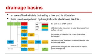
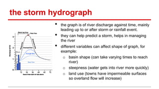
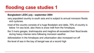
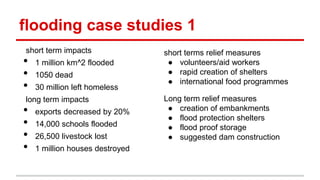
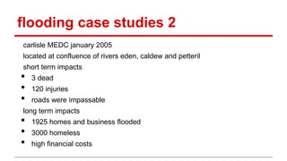
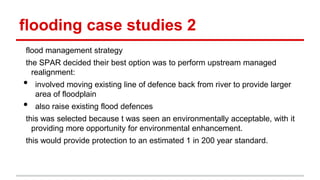
This presentation is a cool resource for doing river revision, especially if you are doing A-levels in Geography.
Here, we will talk about river formation and all related processes that happen with rivers
This presentation is a cool resource for doing river revision, especially if you are doing A-levels in Geography.
Here, we will talk about river formation and all related processes that happen with rivers
An overview and analysis of the Missisippi flood of 2011 and its possible effect on oil refineries along the river.
(Presented on 5/11/2011 at Fuh Hwa Security Investment Trust, Taipei, Taiwan)
An overview and analysis of the Missisippi flood of 2011 and its possible effect on oil refineries along the river.
(Presented on 5/11/2011 at Fuh Hwa Security Investment Trust, Taipei, Taiwan)
Learn about floods, its causes and its types. including many pictures to make this a fun learing slide. have fun! please comment and like! hope you love it! kisesssssssssssssssssssssssssssssssssssssssssssssssssssssssssssssssssssssssssssssssssssssssssssssssssssssssssssssssssssssssssssssssssssssssssssssssssssssssssssssssssssssssssssssssssssssssssssssssssssssssssssssss!
Floods occur somewhere in the world 10,000 times or more each year. With 2015’s spring floods only weeks away, it’s past time to speed up the long-term recovery process for floods. In 2008, after weeks of flooding through Iowa, Illinois, Missouri, Indiana and Wisconsin, the region faced billions of dollars in losses, threats of disease, and a long cleanup. Losses included millions of acres of prime farm land that are still requiring restoration and the rebuilding of large urban areas such as Cedar Rapids, Iowa which alone is estimated to have required at least $1 billion. However, the total direct and indirect losses may never be known. Flood waters during the summer of 2008 seeped into countless wells, affecting drinking water for thousands of homes and businesses across the region. Hazardous materials were also released into the flood waters that ultimately emptied into the Gulf of Mexico exacerbating what marine biologists call a “dead zone” – bodies of water so starved for oxygen that aquatic life can no longer be supported. Presentation courtesy of Dr Walter Hays, Global Alliance for Disaster Reduction.
A torrential rain event during the first full week of March 2016 featuring over two feet of record March rain in the South unleashed major river flooding, rising to historic levels in some areas. Add flooding along the Gulf Coast, and the disaster became a triple assault. In all, 400 homes flooded in Mississippi. Three people were killed in Louisiana, the governor said. In one case, a driver died when floodwater swept his vehicle off a road in Bienville Parish, the Governor's Office of Homeland Security and Emergency Preparedness said. The two others died in Ouachita Parish, according to the Louisiana Department of Health and Hospitals.
Over the years, India has witnessed worst floods causing numerous loss of lives and to property.
Here are some causes and its geomorphic effects.
And some measures of flood control.
River is a most Important agent in geological field and most important roll of the physical, Chemical and biological erosion. It is common factors of river.
Palestine last event orientationfvgnh .pptxRaedMohamed3
An EFL lesson about the current events in Palestine. It is intended to be for intermediate students who wish to increase their listening skills through a short lesson in power point.
How to Make a Field invisible in Odoo 17Celine George
It is possible to hide or invisible some fields in odoo. Commonly using “invisible” attribute in the field definition to invisible the fields. This slide will show how to make a field invisible in odoo 17.
Students, digital devices and success - Andreas Schleicher - 27 May 2024..pptxEduSkills OECD
Andreas Schleicher presents at the OECD webinar ‘Digital devices in schools: detrimental distraction or secret to success?’ on 27 May 2024. The presentation was based on findings from PISA 2022 results and the webinar helped launch the PISA in Focus ‘Managing screen time: How to protect and equip students against distraction’ https://www.oecd-ilibrary.org/education/managing-screen-time_7c225af4-en and the OECD Education Policy Perspective ‘Students, digital devices and success’ can be found here - https://oe.cd/il/5yV
The Indian economy is classified into different sectors to simplify the analysis and understanding of economic activities. For Class 10, it's essential to grasp the sectors of the Indian economy, understand their characteristics, and recognize their importance. This guide will provide detailed notes on the Sectors of the Indian Economy Class 10, using specific long-tail keywords to enhance comprehension.
For more information, visit-www.vavaclasses.com
The Roman Empire A Historical Colossus.pdfkaushalkr1407
The Roman Empire, a vast and enduring power, stands as one of history's most remarkable civilizations, leaving an indelible imprint on the world. It emerged from the Roman Republic, transitioning into an imperial powerhouse under the leadership of Augustus Caesar in 27 BCE. This transformation marked the beginning of an era defined by unprecedented territorial expansion, architectural marvels, and profound cultural influence.
The empire's roots lie in the city of Rome, founded, according to legend, by Romulus in 753 BCE. Over centuries, Rome evolved from a small settlement to a formidable republic, characterized by a complex political system with elected officials and checks on power. However, internal strife, class conflicts, and military ambitions paved the way for the end of the Republic. Julius Caesar’s dictatorship and subsequent assassination in 44 BCE created a power vacuum, leading to a civil war. Octavian, later Augustus, emerged victorious, heralding the Roman Empire’s birth.
Under Augustus, the empire experienced the Pax Romana, a 200-year period of relative peace and stability. Augustus reformed the military, established efficient administrative systems, and initiated grand construction projects. The empire's borders expanded, encompassing territories from Britain to Egypt and from Spain to the Euphrates. Roman legions, renowned for their discipline and engineering prowess, secured and maintained these vast territories, building roads, fortifications, and cities that facilitated control and integration.
The Roman Empire’s society was hierarchical, with a rigid class system. At the top were the patricians, wealthy elites who held significant political power. Below them were the plebeians, free citizens with limited political influence, and the vast numbers of slaves who formed the backbone of the economy. The family unit was central, governed by the paterfamilias, the male head who held absolute authority.
Culturally, the Romans were eclectic, absorbing and adapting elements from the civilizations they encountered, particularly the Greeks. Roman art, literature, and philosophy reflected this synthesis, creating a rich cultural tapestry. Latin, the Roman language, became the lingua franca of the Western world, influencing numerous modern languages.
Roman architecture and engineering achievements were monumental. They perfected the arch, vault, and dome, constructing enduring structures like the Colosseum, Pantheon, and aqueducts. These engineering marvels not only showcased Roman ingenuity but also served practical purposes, from public entertainment to water supply.
Model Attribute Check Company Auto PropertyCeline George
In Odoo, the multi-company feature allows you to manage multiple companies within a single Odoo database instance. Each company can have its own configurations while still sharing common resources such as products, customers, and suppliers.
Welcome to TechSoup New Member Orientation and Q&A (May 2024).pdfTechSoup
In this webinar you will learn how your organization can access TechSoup's wide variety of product discount and donation programs. From hardware to software, we'll give you a tour of the tools available to help your nonprofit with productivity, collaboration, financial management, donor tracking, security, and more.
Ethnobotany and Ethnopharmacology:
Ethnobotany in herbal drug evaluation,
Impact of Ethnobotany in traditional medicine,
New development in herbals,
Bio-prospecting tools for drug discovery,
Role of Ethnopharmacology in drug evaluation,
Reverse Pharmacology.
2. drainage basins
• an area of land which is drained by a river and its tributaries.
• there is a drainage basin hydrological cycle which looks like this...
the cycle is an OPEN system
infiltration is the movement of water downwards from
surface into soil
throughflow is the water that moves down slope
through soil
percolation is the downward movement of water from
soil into rock below
groundwater storage is the water stored in the rock
pores underground
3. the storm hydrograph
• the graph is of river discharge against time, mainly
leading up to or after storm or rainfall event.
• they can help predict a storm, helps in managing
the river
• different variables can affect shape of graph, for
example:
o basin shape (can take varying times to reach
river)
o steepness (water gets into river more quickly)
o land use (towns have impermeable surfaces
so overland flow will increase)
4. valley profiles
types of river erosion:
• hydraulic action - force of air and water on sides and cracks of river
• abrasion - wearing away of bank by the load of the river
• solution/corrosion - removal of chemical ions, eg. calcium.
• attrition - wearing away of the load in the river, loads gets smaller and
smaller
types of river transportation:
• suspension - carried within flow, largest contribution
• saltation - small stones bouncing along river bed
• traction - bigger rocks/boulders rolled along river bed
5. valley profiles
the hjulstrom curve relates the work done by a river to its velocity
competence is the max load a river can carry
capacity is the maximum load carried
In general larger particles require more velocity to be lifted off the bed
Larger particles will be deposited at higher velocities where smaller particles
will remain in transport.
7. valley profiles
In the upper course of a river the velocity is low due to roughness of bed, it
mainly has potential energy. further down the long profile the energy turns
into kinetic energy due to river is bigger and moving more quickly.
wetted perimeter is the length of the banks and the bed that are in contact
with the river. The greater the channel roughness the greater the wetted
perimeter.
the hydraulic radius is a measure of the rivers efficiency, it equals CSA/WP.
The higher the hydraulic radius the more efficient the stream.
8. river landforms
landforms found in upper course include.
• potholes - caused by drilling (abrasion), pebbles collect in depression and
the flow causes them to rotate and create a hollow
• waterfalls - caused by a change in geology with underlying softer rock,
waterfalls migrates upstream due to lip collapsing.
• rapids - steeper sections of the long profile, usually have very turbulent
flow, caused by changes in geology.
middle/lower course landforms
• meanders - there are pools (deeper) and riffles (shallower) parts of the
river and they cause a change in speed, the river flows from one side to
another eroding the banks, on the inside of the meander where there isnt
enough energy there is deposition
9. river landforms
flood plains are flat areas of deposition close to river channel
many rivers have natural embankments called levees, formed during floods,
they can act as a natural flood defence.
deltas are formed when a river enter the sea, as the river slows down it loses
competence and deposits. the fresh water mixes with salty water and they
coagulate called flocculation.
braided channels are created when a river loses competence and look like
small islands.
rejuvenation occurs when its landscape is dominated by erosion, causes
include uplift of land due to melting land ice or uplift of land caused by
tectonics.
10. river landforms
knickpoints, river terraces and incised meanders are created because of the
difference of height between the river and the sea (caused by rejuvenation),
this causes river to gain potential energy thus eroding vertically.
knickpoint are sudden changes in the rivers gradient, river terraces occurs
when a river cuts into its floodplain. Incised meanders are a result of
established meanders cutting vertically into the landscape.
11. flooding
physical causes:
• excessive rainfall = increased overland flow and soil saturation
• intense rainfall, when its > rate of infiltration, overland flow occurs, can be
exacerbated by impermeable surfaces.
• rapidly melting snow
• coastal storm surges
human causes
• urban areas - impermeable surfaces increase overland flow
• deforestation - removes interception store which decreases evaporation.
vegetation store removed, soil has lower infiltration rate. sediment can also
get into the rivers.
• failure of dams
12. flooding
areas at risk from flooding get mapped, flood prediction is not reliable due to
it is based on historical data. recurrence interval can be calculated and tells
us how often a flood will occur.
physical impacts of flooding:
• area of land flooded
• sediment deposited or washed away
• change in rivers’ course eg. meander turns into oxbow lake
human impacts
• economic costs to householders, insurance, businesses, agriculture,
organizing help and aid
• social costs like deaths, homelessness, health issues
13. flooding case studies 1
Bangladesh LEDC july - september 2004
very populated country is south asia and is subject to annual monsoon floods
and cyclones.
most of the country consists of a huge floodplain and delta, 70% of country is
below 1m sea level, also there is snow melt from the himalayas.
the 3 rivers ganges, brahmaputra and meghna all exceeded their flood levels
during heavy intense rains following monsoon weather.
deforestation in the himalayas and urbanisation also increased run off
the level of sea in the bay of bengal was at a record high
14. flooding case studies 1
short term impacts
• 1 million km^2 flooded
• 1050 dead
• 30 million left homeless
long term impacts
• exports decreased by 20%
• 14,000 schools flooded
• 26,500 livestock lost
• 1 million houses destroyed
short terms relief measures
● volunteers/aid workers
● rapid creation of shelters
● international food programmes
Long term relief measures
● creation of embankments
● flood protection shelters
● flood proof storage
● suggested dam construction
15. flooding case studies 2
carlisle MEDC january 2005
located at confluence of rivers eden, caldew and petteril
short term impacts
• 3 dead
• 120 injuries
• roads were impassable
long term impacts
• 1925 homes and business flooded
• 3000 homeless
• high financial costs
16. flooding case studies 2
flood management strategy
the SPAR decided their best option was to perform upstream managed
realignment:
• involved moving existing line of defence back from river to provide larger
area of floodplain
• also raise existing flood defences
this was selected because t was seen an environmentally acceptable, with it
providing more opportunity for environmental enhancement.
this would provide protection to an estimated 1 in 200 year standard.
17. flooding
flood management strategies can be divided into hard and soft engineering
strategies.
hard engineering - either requires construction or landscape change,
includes dams, river straightening, levee construction. they are generally
found in LEDC’s as they are expensive and are protecting high value
property.
soft engineering - floodplain management, wetland conservation and river
banks conservation. Also forecasting comes under it and better forecasting
in bangladesh would have reduced death toll due to more time to react.
river restoration is about enhancing the environment rather than reducing
flood risk, but when rivers are returned to their original state floods may be
less catastrophic and less frequent.