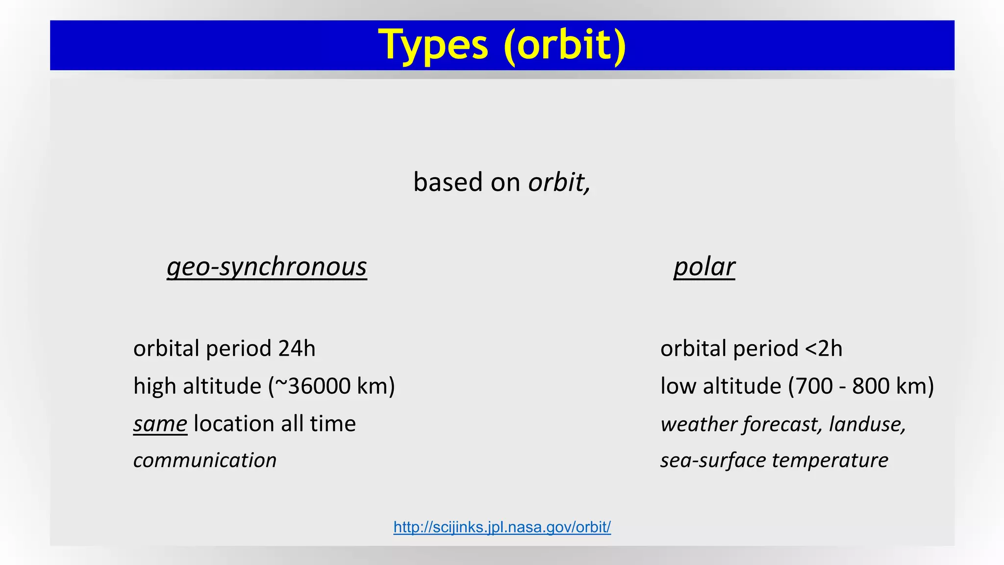
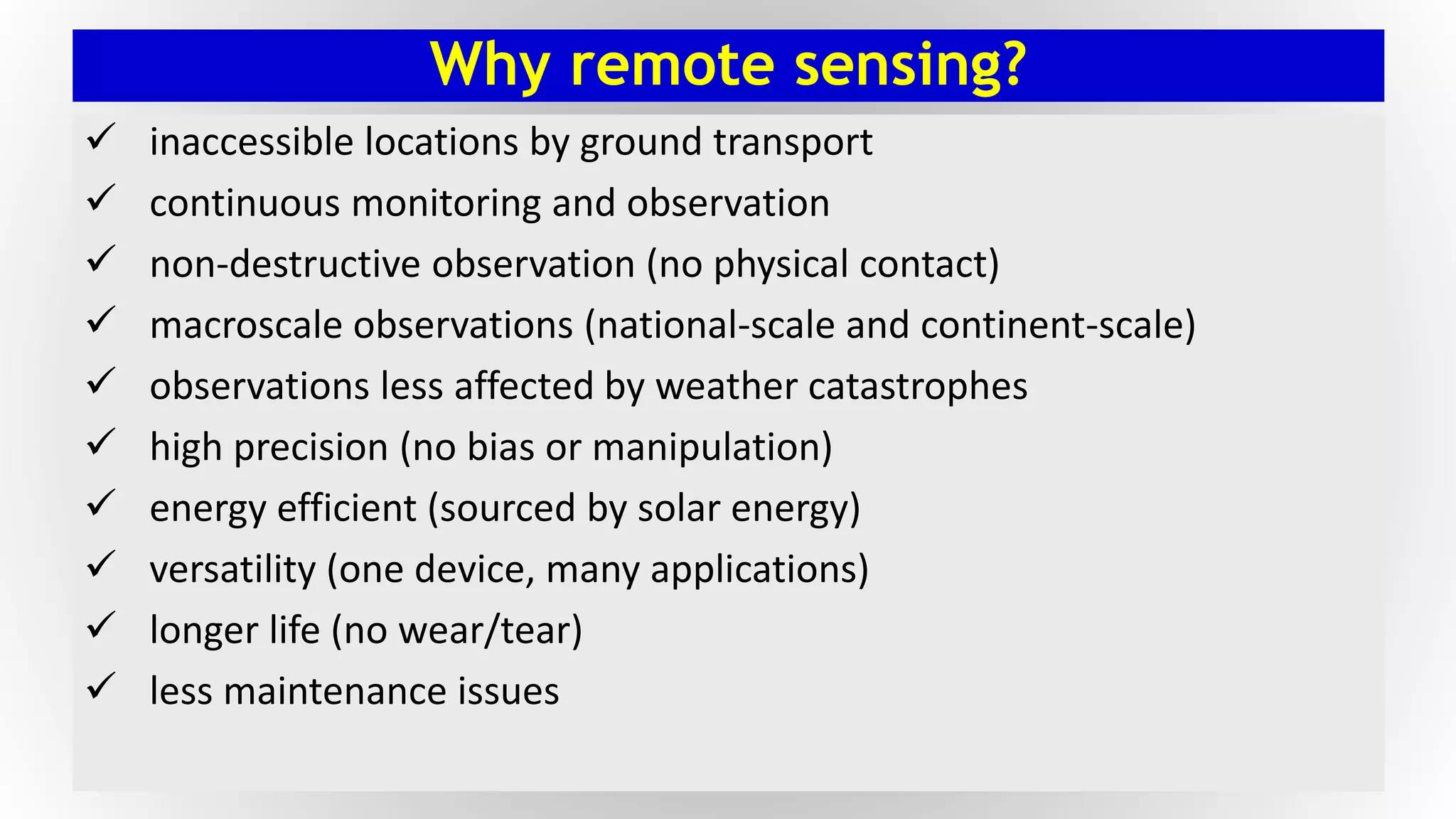
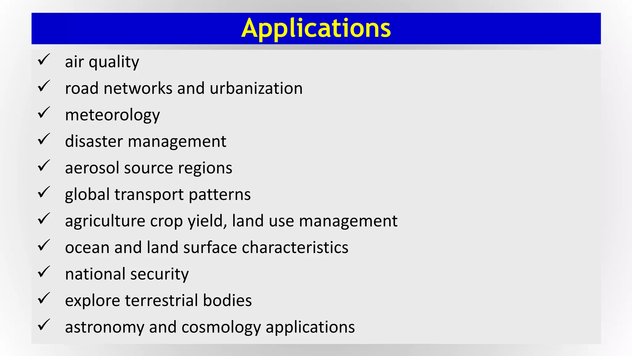
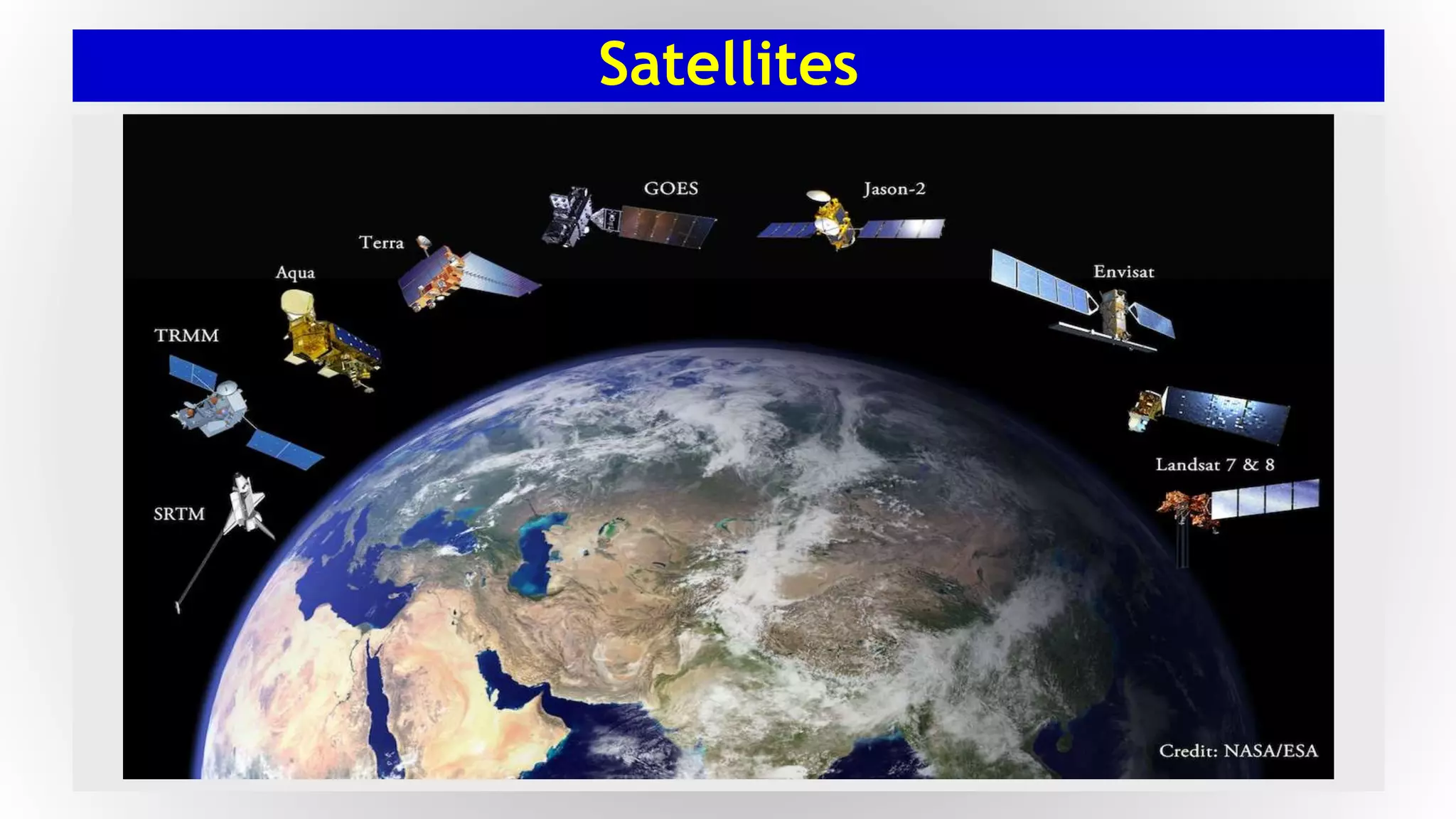
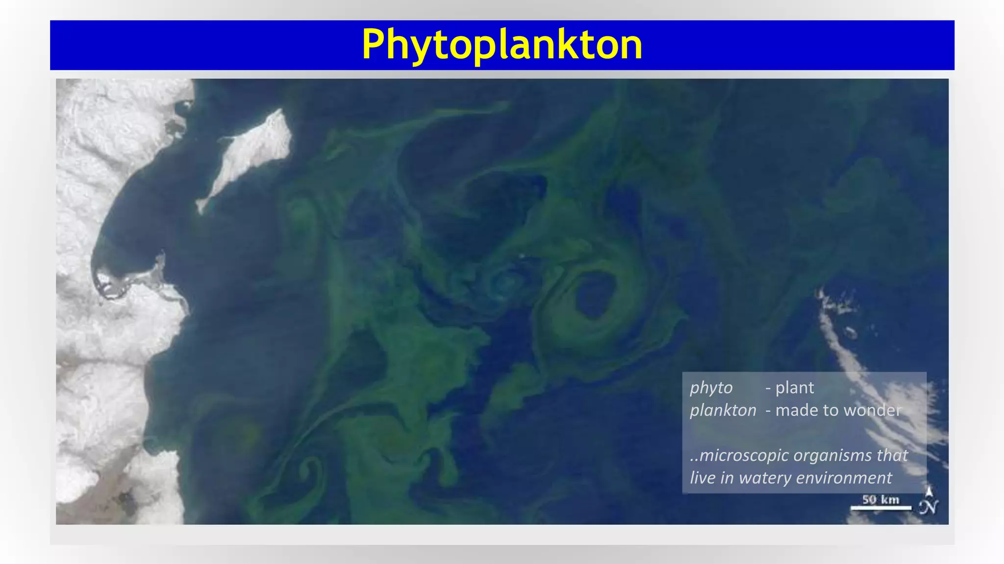
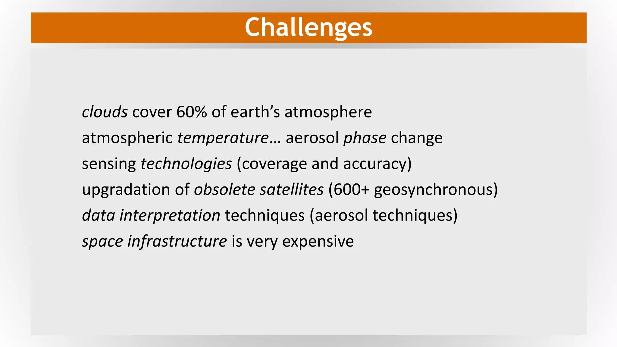
The presentation introduces remote sensing technology and how it is used in studying atmospheric aerosols. Remote Sensing technology uses the optical property of aerosols to detect the presence and the type of aerosol. The type or the characteristics of an aerosol is determined by seven factors which are interpreted from the satellite image. The satellite image is retrieved from geosynchronous and polar satellites, of which the latter is preferred for aerosol applications.
In addition, features and terminologies associated with remote sensing, satellite and aerosol optical properties are discussed. This project emphasizes on an interactive material that is best supplemented with lecture video. It is not designed to be conventional lecture slide. Point to note: the question mark appearing in bottom of the slides indicates the author raised a question during the lecture.
This presentation was delivered in coming-of-age lecture style, in contrast to old-school conventional style. This presentation stimulates audiences to think and act than a banal display of abstract data. The lecture videos can be found at:
[1] Part-1/2 (52 minutes): https://youtu.be/-O_mYoeg-us
[2] Part-2/2 (51 minutes): https://youtu.be/IhHHHZYcY0o
This presentation is done as a part of graduate course titled Aerosol Mechanics in Spring 2016. The author was pursuing MS in Environmental Engineering Sciences at University of Florida during the making of this project.
What is Remote Sensing?
Process of Remote Sensing
Electromagnetic Radiations
Electromagnetic Spectrum
Interaction with Atmosphere
Radiations-Target Interactions
Passive Vs Active Sensing
the presentation is about a literature review upon Aerosol optical depth, its measurement techniques and few work done with this variable in the field of environment and air pollution
This presentation give you a full Introduction about Global Positioning System(GPS).
The following topics are include in this presentation.
History of the GPS
Basic Introduction
How GPS work
Characteristics of GPS
Segments of GPS
-Space Segment
-Control Segment
-User Segment
-GPS Receiver
GPS MAPS
-Raster Maps
-Vector Maps
-Android maps
Applications
-Location
-Tracking
-Timing
-Mapping
-Survey
-Aviation
Advantages and Disadvantages
it is highly useful for geography students in the field of remote sensing and it is in very simple and explanatory for the purpose of simplification with relevant images in this ppt.
physics of remote sensing,ideal remote sensing,swath,platform,sensor,orbit and its characteristics,electromagnetic radiations,EMR solar radiations and its application,shortwave and long waves,spectrul reflectance curve, resolution AND multi concept,FCC,
Evaluating effectiveness of radiometric correction for optical satellite imag...Dang Le
One of our published researches in ACRS 31st in Hanoi.
It has been used for our project in processing optical satellite imagery to detect environmental pollution.
The work is done as part of graduate coursework at University of Florida. The author studied master's in environmental engineering sciences during the making of the presentation.
Application of Multivariate Regression Analysis and Analysis of VarianceKalaivanan Murthy
The work is done as part of graduate coursework at University of Florida. The author studied master's in environmental engineering sciences during the making of the presentation.
APPLICATION OF REMOTE SENSING AND GIS IN AGRICULTURELagnajeetRoy
India is a country that depends on agriculture. Today in this era of technological supremacy, agriculture is also using different new technologies like some robotic machinery to remote sensing and Geographical Information System (GIS) for the betterment of agriculture. It is easy to get the information about that area where human cannot check the condition everyday and help in gathering the data with the help of remote sensing. Whereas GIS helps in preparation of map that shows an accurate representation of data we get through remote sensing. From disease estimation to stress factor due to water, from ground water quality index to acreage estimation in various way agriculture is being profited by the application of remote sensing and GIS in agriculture. The applications of those software or techniques are very new to the agriculture domain still much more exploration is needed in this part. New software’s are developing in different parts of the world and remote sensing. Today farmers understand the beneficiaries of these kinds of techniques to the farm field which help in increasing productivity that will help future generation as technology is hype in traditional system of farming.
The Large Interferometer For Exoplanets (LIFE): the science of characterising...Advanced-Concepts-Team
Studying the atmospheres of a statistically significant number of rocky, terrestrial exoplanets - including the search for habitable and potentially inhabited planets - is one of the major goals of exoplanetary science and possibly the most challenging question in 21st century astrophysics. However, despite being at the top of the agenda of all major space agencies and ground-based observatories, none of the currently planned projects or missions worldwide has the technical capabilities to achieve this goal. In this talk we present new results from the LIFE Mission initiative, which addresses this issue by investigating the scientific potential of a mid infrared nulling interferometer observatory. Here we will focus on the mission's yield estimates, our simulator software as well as various exemplary science cases such as observing Earth- and Venus-twins or searching for phosphine in exoplanetary atmospheres.
Remote sensing is the acquisition of information about an object or phenomenon without making physical contact with the object and thus in contrast to in situ observation. In modern usage, the term generally refers to the use of aerial sensor technologies to detect and classify objects on Earth (both on the surface, and in the atmosphere and oceans) by means of propagated signals (e.g. electromagnetic radiation). It may be split into active remote sensing (when a signal is first emitted from aircraft or satellites)[1][2][3] or passive (e.g. sunlight) when information is merely recorded.
This is all about remote sensing. Remote sensing is the acquisition of information about an object or phenomenon without making physical contact with the object and thus in contrast to on-site observation, especially the Earth.Remote sensing is the process of detecting and monitoring the physical characteristics of an area by measuring its reflected and emitted radiation at a distance from the targeted area. Special cameras collect remotely sensed imagesof the Earth, which help researchers "sense" things about the Earth.
Life Cycle Analysis of Greenhouse Gases for Sugarcane EthanolKalaivanan Murthy
Life cycle greenhouse gas emissions were estimated for two pathways of sugarcane ethanol production. This project was done as a case-study for an environmental agency in February 2020.
Analysis of Stratospheric Tropospheric Intrusion as a Function of Potential V...Kalaivanan Murthy
This work is done as a part of a graduate course on Global Air Pollutants in April 2016. The author was pursuing MS in Environmental Engineering Sciences at the University of Florida during the making of this project.
This work is done as a part of B.Tech. degree requirements in Spring 2013 (Jan-May'13). The author was pursuing B.Tech. in Civil Engineering at the National Institute of Technology Tiruchirappalli during the making of this project.
This presentation will give you an overview of the five essential qualities that every great leader has mastered in his/her journey. It includes the elements of different leadership styles. Hence it is named as 'Hybrid Leadership.'
The presentation was given for the Toastmasters club towards completion of Level-2 in the Dynamic Leadership pathway.
This presentation will take you through a set of five points that will give you an insight into writing better emails.
The presentation was given for the Toastmasters club towards completion of Level-1 in the Dynamic Leadership pathway.
This work is done as a part of degree requirement in Spring 2017. The author was pursuing MS in Environmental Engineering Sciences at University of Florida during the making of this project.
Pairwise Comparison of Daily Ozone Concentration in Tampa-St.Petersburg Regio...Kalaivanan Murthy
A statistical examination of ozone variation between days.
(more description coming soon)
Please visit this link for poster: https://www.slideshare.net/KalaivananMurthy/pairwise-comparison-of-daily-ozone-concentration-in-tampastpetersburg-region-a-research-poster
Pairwise Comparison of Daily Ozone Concentration in Tampa-St.Petersburg Regio...Kalaivanan Murthy
A statistical examination of ozone variation between days.
(more description coming soon)
Please visit this link for abstract, and R code: https://www.slideshare.net/KalaivananMurthy/pairwise-comparison-of-daily-ozone-concentration-in-tampastpetersburg-region-abstract-r-program
Biodiesel vs. Diesel: Air Quality and Economic AspectsKalaivanan Murthy
This work is done as a part of graduate course in Air Quality in Spring 2017. The author was pursuing MS in Environmental Engineering Sciences at University of Florida during the making of this presentation.
(description coming soon)
The project report can be accessed at https://goo.gl/9MQNVV
This work is done as a part of graduate course in Air Quality in Spring 2017. The author was pursuing MS in Environmental Engineering Sciences at University of Florida during the making of this project.
(description coming soon)
Presentation: https://goo.gl/2MnAmG
This presentation outlines project on building an fully autonomous line follower project using infrared sensors and microcontroller.
The project was jointly developed by Kalaivanan Murthy and Surendhar Somasundaram in February 2010. The authors were freshmen at National Institute of Technology - Tiruchirappalli during the making of this project.
Application of Regression Analysis: Model Building and Validation Kalaivanan Murthy
Part-1/4: This project is first part of the four parts in series. This project demonstrates the application of regression analysis which include model building and validation.
This work is done as a part of graduate course titled Statistical Methods in Research in Spring 2017. The author was pursuing MS in Environmental Engineering Sciences at University of Florida during the making of this project.
This project enumerates the attributes of Performance Appraisal in a visual form of representation. It explains 'what is performance appraisal' through pictures, and is best accompanied with the presenter in front.
Performance Appraisal is a method by which the job performance of an employee is evaluated. It is a crucial part of any successful organization, and tries to align individual and group strengths to the organization's vision. There are many different methods of Performance Appraisal, and each has its own perks and limitations. This project discusses some of the most common methods practiced by successful organizations.
This is the Part-2 of the two parts in the series. Please refer to Part-1 for more comprehensive information and technical description. It is presented in a conventional representation with texts and flow-charts. Please refer this website for the Part-1: http://www.slideshare.net/secret/dM2jnMkaKP9c1h
This work is done as a part of undergraduate course titled Management Concepts and Practices in Spring 2013. The author was pursuing B.Tech in Civil Engineering at National Institute of Technology at Tiruchirappalli INDIA during the making of this project.
Presentation Link: http://www.slideshare.net/KalaivananMurthy/gasphase-oxidation-products-of-isoprene
Subject: Advanced Atmospheric Chemistry
This project investigates the oxidation process of isoprene in ambient atmosphere. Oxidation is the main destruction pathway of isoprene. The primary oxidants are hydroxyl radical (OH), nitrate radical (NO3) and ozone (O3).The major products produced in the oxidation are methacrolein (C4H6O), methyl vinyl ketone (C4H6O) and formaldehyde (HCHO). This project emphasis on the reaction pathways of oxidation, the products formed and their yields in different scenarios which are daylight and nighttime, high-NOx and low-NOx.
Isoprene is the most reactive organic compound and the most abundant non-methane organic compound in the atmosphere [troposphere]. It is produced from biogenic sources (trees and plants) in the presence of sunlight. Isoprene in atmosphere is important to be studied because it is a major precursor of ozone in troposphere, and for its active participation in photochemical reactions.
This work is done as a part of graduate course titled Advanced Atmospheric Chemisty in Fall 2016. The author was pursuing MS in Environmental Engineering Sciences at University of Florida during the making of this project.
Respiratory Illness Mortality: Global Health Burden due to Ozone and PM2.5Kalaivanan Murthy
This project discusses global health burden due to ozone and PM2.5. The number of deaths due to ozone is calculated using guidelines from Anenberg S.C. (2010). Ozone and PM2.5 are the main pollutants causing respiratory illness. The impact of these pollutants depends on the concentration and sensitivity of population. The concentration is determined by air quality modeling and the sensitivity is determined by epidemiology.
Attributable Fraction, the fraction of mortality caused by air pollution, is a function of concentration response factor (beta) and concentration-change (dX). CRF for North America is 0.0004. The baseline concentration is taken as preindustrial concentrations for each location. The AF is determined and factored by baseline mortality rate and exposed population to get mortality due to ozone.
AF for ozone is mapped using ArcGIS. The red area is where ozone mortality is highest. The green area is where mortality due to ozone is lowest. It is observed mortality is higher in rural and semi-urban areas than urban areas. It is because ozone is concentrated in urban centers which appears diluted in coarse gridded resolution.
The figures on mortality is provided in the project. Reference: Anenberg, S. C., Horowitz, L. W., Tong, D. Q., & West, J. J. (2010). An estimate of the global burden of anthropogenic ozone and fine particulate matter on premature human mortality using atmospheric modeling. Environmental health perspectives, 118(9), 1189.
This work is done as a part of graduate course titled Global Air Pollutants instructed by Prof. Dr. Henderson in Spring 2016. The author was pursuing MS in Environmental Engineering Sciences at University of Florida during the making of this project.
This project enumerates ways to mitigate climate change through eight strategies. Each strategy, called as 'wedge', when implemented could reduce carbon emission by 1b ton by 2055. This project prioritizes these strategies based on cost of implementation and public opinion. Ranks are assigned from 1 to 8, with 1 for highly feasible [low cost and less criticism] and 8 for hardly feasible.
As seen from the presentation, adopting to biofuels is found to be least feasible (rank-8), followed by fuel switching for electricity (rank-7). In contrast, improving transport efficiency is found to be highly feasible (rank-1), followed by efficiency in electricity production (rank-2). Justifications (qualitative and quantitative) are provided for the ranking of each strategy.
In the concluding slides, stakeholder perspectives are provided for automobile industry and industrial/developing nations. The climate wedges concept was developed by Princeton University, Ford and BP to find solutions to greenhouse gas problem (see references).
Reference:
- Carbon Mitigation Initiative http://cmi.princeton.edu/wedges/
- Stabilization Wedges Game https://cmi.princeton.edu/wedges/pdfs/teachers_guide.pdf
This work is done as a part of graduate course titled Global Air Pollutants in Spring 2016. The author was pursuing MS in Environmental Engineering Sciences at University of Florida during the making of this project.
The presentation discusses about oxidation of Isoprene, the most reactive organic compound. It is also the highest present non-methane organic compound in the atmosphere. Isoprene is produced by plants and is highly reactive in the atmosphere. The major destruction of this compound is by oxidation. The major oxidants, the products formed and their yields in the oxidation process is discussed in the presentation.
The presentation is done as part of graduate coursework at University of Florida. The author studied master's in environmental engineering sciences during the making of the presentation.
The presentation summarizes the project work done on "Seismic Analysis of Elevated Water Tank". Elevated water tanks are important structures that serve the function of supplying municipal water to the civil community. The stability of such structure is highly uncertain in the eve of earthquake. This project analyses the performance of such a structure in the eve of earthquake.
The project is done as a course requirement for undergraduate degree in May 2013. The degree in pursuit was "Bachelor of Technology in Civil Engineering" in National Institute of Technology in Tiruchirappalli (INDIA). The authors were in final year of the study during the making of the project.
Forklift Classes Overview by Intella PartsIntella Parts
Discover the different forklift classes and their specific applications. Learn how to choose the right forklift for your needs to ensure safety, efficiency, and compliance in your operations.
For more technical information, visit our website https://intellaparts.com
About
Indigenized remote control interface card suitable for MAFI system CCR equipment. Compatible for IDM8000 CCR. Backplane mounted serial and TCP/Ethernet communication module for CCR remote access. IDM 8000 CCR remote control on serial and TCP protocol.
• Remote control: Parallel or serial interface.
• Compatible with MAFI CCR system.
• Compatible with IDM8000 CCR.
• Compatible with Backplane mount serial communication.
• Compatible with commercial and Defence aviation CCR system.
• Remote control system for accessing CCR and allied system over serial or TCP.
• Indigenized local Support/presence in India.
• Easy in configuration using DIP switches.
Technical Specifications
Indigenized remote control interface card suitable for MAFI system CCR equipment. Compatible for IDM8000 CCR. Backplane mounted serial and TCP/Ethernet communication module for CCR remote access. IDM 8000 CCR remote control on serial and TCP protocol.
Key Features
Indigenized remote control interface card suitable for MAFI system CCR equipment. Compatible for IDM8000 CCR. Backplane mounted serial and TCP/Ethernet communication module for CCR remote access. IDM 8000 CCR remote control on serial and TCP protocol.
• Remote control: Parallel or serial interface
• Compatible with MAFI CCR system
• Copatiable with IDM8000 CCR
• Compatible with Backplane mount serial communication.
• Compatible with commercial and Defence aviation CCR system.
• Remote control system for accessing CCR and allied system over serial or TCP.
• Indigenized local Support/presence in India.
Application
• Remote control: Parallel or serial interface.
• Compatible with MAFI CCR system.
• Compatible with IDM8000 CCR.
• Compatible with Backplane mount serial communication.
• Compatible with commercial and Defence aviation CCR system.
• Remote control system for accessing CCR and allied system over serial or TCP.
• Indigenized local Support/presence in India.
• Easy in configuration using DIP switches.
Quality defects in TMT Bars, Possible causes and Potential Solutions.PrashantGoswami42
Maintaining high-quality standards in the production of TMT bars is crucial for ensuring structural integrity in construction. Addressing common defects through careful monitoring, standardized processes, and advanced technology can significantly improve the quality of TMT bars. Continuous training and adherence to quality control measures will also play a pivotal role in minimizing these defects.
Automobile Management System Project Report.pdfKamal Acharya
The proposed project is developed to manage the automobile in the automobile dealer company. The main module in this project is login, automobile management, customer management, sales, complaints and reports. The first module is the login. The automobile showroom owner should login to the project for usage. The username and password are verified and if it is correct, next form opens. If the username and password are not correct, it shows the error message.
When a customer search for a automobile, if the automobile is available, they will be taken to a page that shows the details of the automobile including automobile name, automobile ID, quantity, price etc. “Automobile Management System” is useful for maintaining automobiles, customers effectively and hence helps for establishing good relation between customer and automobile organization. It contains various customized modules for effectively maintaining automobiles and stock information accurately and safely.
When the automobile is sold to the customer, stock will be reduced automatically. When a new purchase is made, stock will be increased automatically. While selecting automobiles for sale, the proposed software will automatically check for total number of available stock of that particular item, if the total stock of that particular item is less than 5, software will notify the user to purchase the particular item.
Also when the user tries to sale items which are not in stock, the system will prompt the user that the stock is not enough. Customers of this system can search for a automobile; can purchase a automobile easily by selecting fast. On the other hand the stock of automobiles can be maintained perfectly by the automobile shop manager overcoming the drawbacks of existing system.
CFD Simulation of By-pass Flow in a HRSG module by R&R Consult.pptxR&R Consult
CFD analysis is incredibly effective at solving mysteries and improving the performance of complex systems!
Here's a great example: At a large natural gas-fired power plant, where they use waste heat to generate steam and energy, they were puzzled that their boiler wasn't producing as much steam as expected.
R&R and Tetra Engineering Group Inc. were asked to solve the issue with reduced steam production.
An inspection had shown that a significant amount of hot flue gas was bypassing the boiler tubes, where the heat was supposed to be transferred.
R&R Consult conducted a CFD analysis, which revealed that 6.3% of the flue gas was bypassing the boiler tubes without transferring heat. The analysis also showed that the flue gas was instead being directed along the sides of the boiler and between the modules that were supposed to capture the heat. This was the cause of the reduced performance.
Based on our results, Tetra Engineering installed covering plates to reduce the bypass flow. This improved the boiler's performance and increased electricity production.
It is always satisfying when we can help solve complex challenges like this. Do your systems also need a check-up or optimization? Give us a call!
Work done in cooperation with James Malloy and David Moelling from Tetra Engineering.
More examples of our work https://www.r-r-consult.dk/en/cases-en/
Student information management system project report ii.pdfKamal Acharya
Our project explains about the student management. This project mainly explains the various actions related to student details. This project shows some ease in adding, editing and deleting the student details. It also provides a less time consuming process for viewing, adding, editing and deleting the marks of the students.
Event Management System Vb Net Project Report.pdfKamal Acharya
In present era, the scopes of information technology growing with a very fast .We do not see any are untouched from this industry. The scope of information technology has become wider includes: Business and industry. Household Business, Communication, Education, Entertainment, Science, Medicine, Engineering, Distance Learning, Weather Forecasting. Carrier Searching and so on.
My project named “Event Management System” is software that store and maintained all events coordinated in college. It also helpful to print related reports. My project will help to record the events coordinated by faculties with their Name, Event subject, date & details in an efficient & effective ways.
In my system we have to make a system by which a user can record all events coordinated by a particular faculty. In our proposed system some more featured are added which differs it from the existing system such as security.
Industrial Training at Shahjalal Fertilizer Company Limited (SFCL)MdTanvirMahtab2
This presentation is about the working procedure of Shahjalal Fertilizer Company Limited (SFCL). A Govt. owned Company of Bangladesh Chemical Industries Corporation under Ministry of Industries.
Overview of the fundamental roles in Hydropower generation and the components involved in wider Electrical Engineering.
This paper presents the design and construction of hydroelectric dams from the hydrologist’s survey of the valley before construction, all aspects and involved disciplines, fluid dynamics, structural engineering, generation and mains frequency regulation to the very transmission of power through the network in the United Kingdom.
Author: Robbie Edward Sayers
Collaborators and co editors: Charlie Sims and Connor Healey.
(C) 2024 Robbie E. Sayers
TECHNICAL TRAINING MANUAL GENERAL FAMILIARIZATION COURSEDuvanRamosGarzon1
AIRCRAFT GENERAL
The Single Aisle is the most advanced family aircraft in service today, with fly-by-wire flight controls.
The A318, A319, A320 and A321 are twin-engine subsonic medium range aircraft.
The family offers a choice of engines
NO1 Uk best vashikaran specialist in delhi vashikaran baba near me online vas...Amil Baba Dawood bangali
Contact with Dawood Bhai Just call on +92322-6382012 and we'll help you. We'll solve all your problems within 12 to 24 hours and with 101% guarantee and with astrology systematic. If you want to take any personal or professional advice then also you can call us on +92322-6382012 , ONLINE LOVE PROBLEM & Other all types of Daily Life Problem's.Then CALL or WHATSAPP us on +92322-6382012 and Get all these problems solutions here by Amil Baba DAWOOD BANGALI
#vashikaranspecialist #astrologer #palmistry #amliyaat #taweez #manpasandshadi #horoscope #spiritual #lovelife #lovespell #marriagespell#aamilbabainpakistan #amilbabainkarachi #powerfullblackmagicspell #kalajadumantarspecialist #realamilbaba #AmilbabainPakistan #astrologerincanada #astrologerindubai #lovespellsmaster #kalajaduspecialist #lovespellsthatwork #aamilbabainlahore#blackmagicformarriage #aamilbaba #kalajadu #kalailam #taweez #wazifaexpert #jadumantar #vashikaranspecialist #astrologer #palmistry #amliyaat #taweez #manpasandshadi #horoscope #spiritual #lovelife #lovespell #marriagespell#aamilbabainpakistan #amilbabainkarachi #powerfullblackmagicspell #kalajadumantarspecialist #realamilbaba #AmilbabainPakistan #astrologerincanada #astrologerindubai #lovespellsmaster #kalajaduspecialist #lovespellsthatwork #aamilbabainlahore #blackmagicforlove #blackmagicformarriage #aamilbaba #kalajadu #kalailam #taweez #wazifaexpert #jadumantar #vashikaranspecialist #astrologer #palmistry #amliyaat #taweez #manpasandshadi #horoscope #spiritual #lovelife #lovespell #marriagespell#aamilbabainpakistan #amilbabainkarachi #powerfullblackmagicspell #kalajadumantarspecialist #realamilbaba #AmilbabainPakistan #astrologerincanada #astrologerindubai #lovespellsmaster #kalajaduspecialist #lovespellsthatwork #aamilbabainlahore #Amilbabainuk #amilbabainspain #amilbabaindubai #Amilbabainnorway #amilbabainkrachi #amilbabainlahore #amilbabaingujranwalan #amilbabainislamabad
4. Two Areas
remote sensing
technology to capture
optical wave changes
satellite - sensors
aerosol technology
deducing true form from remote
sensing inputs
optical properties
6. What is Remote Sensing?
Science of acquiring information about an object
without having a physical contact.
7. Terminology
“Science – and the art – of
identifying, observing, and measuring an object
without coming into direct contact with it.”
Ms. Evelyn Pruitt
US Office of Naval Research
1950’s
Source: Earth Observatory, National Aeronautics and Space Administration
8. What others say?
“acquisition of information about an object or phenomenon without making physical
contact with object.. thus in contrast to site observation”
“..in modern usage.. use of aerial sensor technologies to detect and classify objects on
earth.. surface, atmosphere, oceans.. by means of propagated signals on earth”
– Wikipedia (Feb 2016)
“collecting and interpreting information about the environment and the surface.. from a
distance.. primarily by sensing radiation that is naturally emitted or reflected.. by sensing
signals transmitted from a device and reflected back to it.”
– Environmental Systems Research Institute (Feb 2016)
13. Types (source)
based on light source,
passive active
external source self source
(sun, earth) (electromagnetic pulse)
eg. Landsat, ASTER, AVHRR eg. LIDAR, RADAR, SONAR
not only visible
14. Types (orbit)
based on orbit,
geo-synchronous polar
orbital period 24h orbital period <2h
high altitude (~36000 km) low altitude (700 - 800 km)
same location all time weather forecast, landuse,
communication sea-surface temperature
http://scijinks.jpl.nasa.gov/orbit/
20. Why remote sensing?
inaccessible locations by ground transport
continuous monitoring and observation
non-destructive observation (no physical contact)
macroscale observations (national-scale and continent-scale)
observations less affected by weather catastrophes
high precision (no bias or manipulation)
energy efficient (sourced by solar energy)
versatility (one device, many applications)
longer life (no wear/tear)
less maintenance issues
30. Applications
air quality
road networks and urbanization
meteorology
disaster management
aerosol source regions
global transport patterns
agriculture crop yield, land use management
ocean and land surface characteristics
national security
explore terrestrial bodies
astronomy and cosmology applications
33. Organizations
founded
NASA National Aeronautics and Space Administration 1958
IKI RAN Russian Space Research Institute 1965
ISRO Indian Space Research Organization 1969
NSDAJ National Space Development Agency of Japan 1969
GAC German Aerospace Center 1969
ESA European Space Agency 1975
RSC Russian Federal Space Agency 1992
CNSA China National Space Administration 1993
38. Characterization
f (x, y, z, t, D, C, S, X)
x, y = ground location
z = altitude
t = time
D = particle diameter
C = composition
S = shape
X = mixing
42. distinct terms
radiation
emission or transmission of energy
..in form of waves or particles
electromagnetic
particle (α, β, neutron)
acoustic (ultrasound,sound,seismic)
gravitational
electromagnetic radiation
radiant energy released
..by electromagnetic process
radio, infrared, visible etc.
45. How to know?
deciding criteria
𝑃
𝑅0
..three cases
< 1
P - phase function = 1
R0 - surface reflectance > 1
46. case-(i)
phase function is lesser than surface reflectance
𝑃
𝑅0
< 1
addition of aerosols
decrease
true reflection
http://earthobservatory.nasa.gov/IOTD/view.php?id=84557
47. case-(ii)
phase function is equal to surface reflectance
𝑃
𝑅0
= 1
addition of aerosols
will not change
apparent reflection
48. case-(iii)
phase function is greater than surface reflectance
𝑃
𝑅0
> 1
addition of aerosols
increase
apparent reflection
61. Challenges
clouds cover 60% of earth’s atmosphere
atmospheric temperature… aerosol phase change
sensing technologies (coverage and accuracy)
upgradation of obsolete satellites (600+ geosynchronous)
data interpretation techniques (aerosol techniques)
space infrastructure is very expensive
62. let’s summarize
remote sensing is a science, technology and art
two types of sensing: active and passive
two types of orbits: geosynchronous and polar
four characteristics: spatial, spectral, radiometric, temporal
one governing phenomenon: optical properties
challenges: surface reflectance and clouds
63. Sources
Satellite-based measurement of atmospheric aerosols
Rudolf B. Husar
Department of Energy, Environmental and Chemical Engineering,
Washington University, Missouri
Earth Observatory
National Aeronautics and Space Administration
Wikipedia
Wikimedia Foundation
and other sources as well…
64. Further Reading
Atmospheric Chemistry and Physics:
from air pollution to climate change (2006)
John H. Seinfeld - Spyros N. Pandis
Visibility: Science and Regulation (2002)
John G. Watson
Remote Sensing of Tropospheric Aerosols from Space (1999)
Michael D. King
Remote Sensing of Particulate Pollution from Space:
have we reached the promised land (2009)
Raymond M. Hoff - Sundar A. Christopher
The characterization of aerosols distributed with respect to size
and chemical composition (1970)
S.K. Friedlander
Be sure to credit the previous presenter. Bioaerosols by Mr. Ringer
Remember always, the highest energy ever produced is in sun, where fusion occurs which is nothing by a bombardment of sub-atmonic particles.
Technical fault can happen at any time, so we must be prepared.
Working knowledge of remote sensing, not a researching knowledge, but this may help you to start one.
Try to give an disclaimer at the end about the pace, technical level, acknowledgement,
Remote Sensing has many applications. Aerosol has complex behavior.
Site observation, tachymeter
Source: Earth Observatory, National Aeronautics and Space Administration
Tacheometer or tacheymeter
A point of discussion: optical characteristics depends only on object. For changes in light, the device has to be calibrated.
Try to delete his name and put it in the end. Try to incorporate scattering and extinction in this.
Remember OZONE layer.
know
Tacheometer or tacheymeter
http://www.geo.mtu.edu/rs4hazards/ksdurst/website/lectures/RemoteSensing.pdf
ASTER Advanced Spaceborne Thermal Emission and Reflection Radiometer
Tacheometer or tacheymeter
http://www.geo.mtu.edu/rs4hazards/ksdurst/website/lectures/RemoteSensing.pdf
ASTER Advanced Spaceborne Thermal Emission and Reflection Radiometer
spatial resolution and Coverage..
spectral resolution: suppose I want a cyan. Can it separate the incident light?
sensors ability to discriminate very slight differences in (reflected or emitted) energy
Temporal resolution is the revisit period, and is the length of time for a satellite to complete one entire orbit cycle
Unit of brightness is Lumens.
Geostationary satellites have low spatial coverage than polar satellite. Why?
Human eye ability is only in visible range.
<lambda>min… <lambda>max
See.. I have details, but I don’t have sufficient space to store them. In the above example, it needs 11 bits to store the accuracy of image.
Same way as we humans cannot distinguish between different colors. We cannot differentiate between chestnut and brown.
Geostationary satellite has higher temporal resolution than polar satellite. Why?
internal mixing: physical, chemical and optical properties need to be considered jointly.
Color Filter: same as you see in the mobile.
First you need to understand about optical properties of aerosol in ground. Only then you will be able to discern the pattern
What is the concentration of ozone.. change of phase or constituents..?
First you need to understand about optical properties of aerosol in ground. Only then you will be able to discern the pattern
What is the concentration of ozone.. change of phase or constituents..?
First you need to understand about optical properties of aerosol in ground. Only then you will be able to discern the pattern
What is the concentration of ozone.. change of phase or constituents..?
First you need to understand about optical properties of aerosol in ground. Only then you will be able to discern the pattern
What is the concentration of ozone.. change of phase or constituents..?