2004-10-03 Co-retrieval of Aerosol and Surface Reflectance: Analysis of Daily US SeaWiFS Data for 2000-2002
•Download as PPT, PDF•
0 likes•214 views
The document discusses a method for co-retrieving aerosol and surface reflectance from daily SeaWiFS satellite data from 2000-2002. It describes preprocessing the raw satellite data, identifying preliminary clear days using a time series analysis approach, and further refining the surface reflectance estimates and removing residual haze through spectral analysis. Results show seasonal surface reflectance maps for the eastern and western US and an 8-month animation of the retrieved data.
Report
Share
Report
Share
![Radiation detected by satellites ,[object Object],[object Object],[object Object],[object Object]](data:image/gif;base64,R0lGODlhAQABAIAAAAAAAP///yH5BAEAAAAALAAAAAABAAEAAAIBRAA7)
Recommended
2004-06-24 Co-retrieval of Aerosol and Surface Reflectance: Analysis of Daily...
The document summarizes a method for co-retrieving aerosol and surface reflectance from daily SeaWiFS satellite data from 2000-2002. It describes how aerosols scatter and absorb incoming radiation, obscuring the surface reflectance detected by the sensor. The method uses a time series analysis to identify clear "anchor" days with minimal aerosol scattering to retrieve the surface reflectance. It then uses a radiative transfer model along with the surface reflectance values to iteratively retrieve the aerosol optical thickness and refine the surface reflectance estimates. Results show seasonal changes in surface reflectance over eastern and western US regions.
2004-06-23 Retrieval of smoke aerosol loading from remote sensing data
This document summarizes a method for quantifying biomass burning aerosol loading using remote sensing data. It describes retrieving aerosol optical thickness from satellite imagery by subtracting surface reflectance from total reflectance. Daily aerosol maps are generated and cleaned to filter out clouds and other interferences. Continuing work includes estimating smoke fluxes and fusing multiple data sources to improve quantification of biomass burning for climate modeling.
1 Sat Intro
http://capitawiki.wustl.edu/index.php/20041014_AIR-257:_Satellite_Detection_of_Aerosols_Concepts_and_Theory
Co Retriaval2
http://capitawiki.wustl.edu/index.php/20050201_Co-Retrieval_of_Aerosol_Color_and_Surface_Color_from_SeaWiFS_Satellite_Images
2005-02-01 Co-Retrieval of Aerosol Color and Surface Color from SeaWiFS Satel...
The document discusses a method for simultaneously retrieving aerosol optical properties and aerosol-free surface reflectance from satellite images. SeaWiFS satellite data is used to co-retrieve the aerosol optical thickness and surface reflectance over land and ocean pixels. Iterative procedures are used to separate the effects of aerosols and surfaces on measured reflectance. Preliminary results over the northeastern US demonstrate the ability to map aerosol patterns and correct surface reflectance for aerosol effects.
Meterological Technology International, Nov 2010
Improving Resolution: A Description of the Characteristics and Capabilities of the Advanced Baseline Imager
Sat fc j-intro_mw_remotesensing
This document provides an introduction to microwave remote sensing, including an overview of microwave instrumentation, frequency channels, and applications. It discusses how microwave sensing complements other methods by providing vertical atmospheric profiles and observing through non-precipitating clouds. Examples are given of products like total precipitable water, cloud liquid water, and wind speed that are derived from combining microwave channel measurements.
2005-12-05 Aerosol Characterization Using the SeaWiFS Sensor and Surface Data
This document discusses the challenge of characterizing particulate matter using satellite and surface data due to the complex six-dimensional nature of aerosols. It presents an approach using SeaWiFS satellite data along with surface observations to derive patterns of dust, smoke and haze over the United States from 2000 to 2003. Specific examples are given of using this method to estimate smoke emissions from agricultural fires in Kansas in April 2003 and analyze seasonal and regional trends in aerosol optical thickness from SeaWiFS data over summers from 2000 to 2004.
Microwave remote sensing
The document discusses the history and applications of microwave remote sensing. It began with US military research after World War II and studies by NASA in the 1960s to use microwave technology for earth observation. Key developments included airborne and spaceborne sensors to measure surface scattering properties and models to explain microwave interactions with natural targets. Current applications of microwave remote sensing include weather monitoring, navigation, imaging, and mapping for both civilian and military uses.
07 big skyearth_dlr_7_april_2016
This document discusses using high resolution maps and 3D reconstructions of the atmosphere to study meteorological phenomena. It outlines various remote sensing techniques and datasets that can be used, including synthetic aperture radar interferometry (InSAR) and GPS tomography. InSAR phase measurements contain contributions from topography, atmospheric water vapor, and surface deformation. The document explores how the atmospheric signal in InSAR data is related to the precipitable water vapor content integrated along the radar signal path. This information could help identify patterns in atmospheric dynamics and types of clouds.
Seismic reflection at lang kawi
1) Seismic reflection surveys were conducted at Ayer Hangat Site to investigate shallow subsurface structures and identify the occurrence and flow of hot water in the area to help with development plans for a geothermal resort.
2) 49 seismic shots were acquired using a land streamer with 24 geophones spaced 1m apart and a 5m source offset to generate common offset gathers of the seismic data.
3) Preliminary analysis of the common offset gathers indicates the possible location of groundwater or geothermal aquifers in the study area, and further velocity analysis is needed to determine the depth of the aquifers.
6 g-considering clouds
Parameterisations of cloud cover in simple radiation models. As used in the class of Hydrology at the University of Trento
GPS
GPS uses a constellation of 24 satellites that orbit Earth and emit signals to allow GPS receivers to determine their precise location. It was developed by the U.S. Department of Defense and consists of three segments - the space segment with the satellites, the control segment consisting of ground stations that monitor the satellites, and the user segment made up of receivers that detect satellite radio signals and use triangulation to calculate the user's position. GPS has both military and civilian applications including navigation, mapping, tracking resources and people.
GPS-errors-2
This document discusses GPS error sources and techniques for improving GPS accuracy, including:
- The troposphere causes delays in GPS signals and is a source of error. Techniques like WAAS and LAAS use reference stations and satellites to correct for tropospheric delays.
- Good satellite geometry with low PDOP provides the most accurate GPS positioning. Dilution of precision metrics like PDOP indicate satellite geometry quality.
- Ambiguity resolution techniques using dual or triple frequency carrier phase and code data can fix integer ambiguities and improve positioning accuracy to centimeter-level.
Single and Dual Frequency Solution In GPS
It describes the single and dual frequency solution in gps and also describes the effect of ionosphere and its elimination.
Analysis of large scale soil spectral libraries
http://www.fao.org/globalsoilpartnership
This presentation was made during the International Workshop "Soil Spectroscopy: the present and future of Soil Monitoring" that took place at FAO HQ Rome, Italy from 4-6 December 2013. This presentation was made by Antoine Stevens, Marco Nocita & Bas van Wesemael, and it has the objective to present ANALYSIS OF LARGE SCALE SOIL SPECTRAL LIBRARIES.
©FAO: http://www.fao.org
The use of spectral libraries to reduce the influence of soil moisture on the...
http://www.fao.org/globalsoilpartnership
This presentation was made during the International Workshop "Soil Spectroscopy: the present and future of Soil Monitoring" that took place at FAO HQ Rome, Italy from 4-6 December 2013. This presentation was made by Castaldi F., Casa R., PalomboA., PascucciS. & PignattiS. , and it has the objective to present The use of spectral libraries to reduce the influence of soil moisture on the estimation of soil properties from satellite imaging spectroscopy.
©FAO: http://www.fao.org
Flat and curved earth propagation
The document discusses various factors that affect radio wave propagation beyond the simple free space model. It covers how the earth's atmosphere, including the troposphere, interference zone, and ionosphere, can refract, absorb and alter waves. Ground reflections are also affected by curvature of the earth and surface roughness. The pattern propagation factor quantifies the reduction in signal strength from indirect paths compared to the direct path between antennas, accounting for earth reflection coefficients and phase differences between paths.
TU2.L10 - ACCURATE MONITORING OF TERRESTRIAL AEROSOLS AND TOTAL SOLAR IRRADIA...
The Glory mission aims to better understand the role of aerosols and solar irradiance in climate change through two instruments: the Aerosol Polarimetry Sensor (APS) and the Total Irradiance Monitor (TIM). APS will make more accurate measurements of aerosols using polarization to reduce uncertainties in aerosol properties. TIM will extend the 30-year record of total solar irradiance measurements with improved accuracy and stability. The NASA Glory spacecraft carrying these instruments is scheduled to launch in November 2010.
Surveying ii ajith sir class5
Microwave sensing systems use sensors that operate in the microwave portion of the electromagnetic spectrum between 1 mm and 1 m wavelengths. These sensors include radars and radiometers that can image outside the visible and infrared regions. Microwaves can penetrate haze, clouds, smoke and pollution, allowing these sensors to image in all weather conditions unlike visible and infrared sensors. Common microwave remote sensing platforms include synthetic aperture radar, scatterometers and radar altimeters.
Dryden2011Poster
The document summarizes information about water vapor in Earth's atmosphere and its impact on infrared astronomy observations from airborne observatories like SOFIA. It discusses how most water vapor is contained below the troposphere. Weather balloon data and atmospheric models are used to calculate water vapor loading at different altitudes and locations to help determine SOFIA's optimal flight paths for observations. The document presents results comparing water vapor loading estimates from the GEOS-5 atmospheric model to actual sounding data from Wyoming at altitudes of 11.5 km, 13.1 km, and above SOFIA's flying range.
Remote Sensing fundamentals
This document provides an overview of remote sensing including:
1. The history of remote sensing from early aerial photography to modern satellite systems.
2. The principles of electromagnetic radiation and how different sensors capture radiation in various parts of the spectrum to analyze objects.
3. The various types of remote sensing platforms, sensors, and resolutions including spatial, spectral, temporal, and radiometric and how they provide information.
4. Common applications of remote sensing like land use mapping, change detection, environmental monitoring, and more.
Satellite Mapping
1. Satellite mapping has provided valuable data for analyzing natural resources and monitoring environmental changes over time. Landsat and SPOT satellites collect multispectral imagery to map the Earth's surface and resources.
2. Geostationary weather satellites like GOES continuously image the full disk of the Earth and provide visible and infrared views of cloud patterns and formations to analyze weather systems.
3. Polar orbiter satellites measure temperature, ice, vegetation, snow cover and other atmospheric data to study climate and environmental conditions. Combined data from different satellites allows comprehensive monitoring of the planet.
Lecture for landsat
The document discusses properties of Landsat satellites and remote sensing data. It provides details on:
- The history and timeline of Landsat satellites and their sensors from Landsat 1 to Landsat 7.
- How Landsat data is processed to convert digital numbers to radiances and reflectances and apply atmospheric corrections.
- How different surface features like vegetation, soil and water absorb electromagnetic radiation differently, enabling their identification in remote sensing imagery.
Esap2011
The document discusses simulation of earthquake ground motion at the Zoser Pyramid in Saqqara, Egypt to aid ongoing restoration projects. It aims to:
1) Assess seismicity near the pyramid using the H/V method to determine natural frequency and amplification. Recordings found a natural frequency of 1 Hz and amplification of 1.5.
2) Simulate ground motion from the 1992 Cairo earthquake using SMSIM software. This estimated a peak ground acceleration of 135 gal from a magnitude 6.3 earthquake 14 km away.
3) Discuss how the results can inform restoration of damages to the pyramid from the 1992 earthquake, especially stabilizing the shaft ceiling.
WE4.L10.5: ADVANCES IN NIGHTTIME SATELLITE REMOTE SENSING CAPABILITIES VIA TH...
The document discusses new capabilities for nighttime satellite remote sensing that will be enabled by the Visible Infrared Imaging Radiometer Suite (VIIRS) Day/Night Band (DNB) sensor on the Joint Polar Satellite System. The DNB will allow detection of low levels of visible light, enabling observations of clouds, aerosols, snow cover and other environmental parameters at night. It provides examples of potential multi-spectral applications using the DNB, including lunar reflection methods, detection of clouds, fires, dust, and city lights. The high resolution nighttime data from DNB presents opportunities to augment existing environmental data records.
2004-09-29 Status Report on CATT and FASTNET
The document provides an overview and status report of the CATT (Combined Aerosol Trajectory Tools) and FASTNET (Fast Aerosol Sensing Tools for Natural Event Tracking) projects. It describes how these projects, along with their data and tools, have been integrated into the DataFed.Net system, which allows users to access, analyze, compare, and interpret air quality and meteorological data. It also outlines future plans to expand the available data and analytical capabilities within these projects.
040715 Catt Report Pics
http://capitawiki.wustl.edu/index.php/20041015_Combined_Aerosol_Trajectory_Tool%2C_CATT_Status_Report_on_Tools_Development_and_Use
17 CCONSEJOS PARA TU VIDA
El documento ofrece 17 consejos para tener un feliz día, incluyendo establecer metas alcanzables, sonreír, compartir con los demás, ayudar a los demás, mantener un espíritu joven, ser simpático con todos, conservar la calma bajo presión, hacer el ambiente menos tenso con simpatía, perdonar molestias de otros, valorar amigos verdaderos, cooperar para obtener grandes resultados, tener confianza en uno mismo, respetar a quienes pasan por momentos difíciles, dejarse llevar
More Related Content
What's hot
Microwave remote sensing
The document discusses the history and applications of microwave remote sensing. It began with US military research after World War II and studies by NASA in the 1960s to use microwave technology for earth observation. Key developments included airborne and spaceborne sensors to measure surface scattering properties and models to explain microwave interactions with natural targets. Current applications of microwave remote sensing include weather monitoring, navigation, imaging, and mapping for both civilian and military uses.
07 big skyearth_dlr_7_april_2016
This document discusses using high resolution maps and 3D reconstructions of the atmosphere to study meteorological phenomena. It outlines various remote sensing techniques and datasets that can be used, including synthetic aperture radar interferometry (InSAR) and GPS tomography. InSAR phase measurements contain contributions from topography, atmospheric water vapor, and surface deformation. The document explores how the atmospheric signal in InSAR data is related to the precipitable water vapor content integrated along the radar signal path. This information could help identify patterns in atmospheric dynamics and types of clouds.
Seismic reflection at lang kawi
1) Seismic reflection surveys were conducted at Ayer Hangat Site to investigate shallow subsurface structures and identify the occurrence and flow of hot water in the area to help with development plans for a geothermal resort.
2) 49 seismic shots were acquired using a land streamer with 24 geophones spaced 1m apart and a 5m source offset to generate common offset gathers of the seismic data.
3) Preliminary analysis of the common offset gathers indicates the possible location of groundwater or geothermal aquifers in the study area, and further velocity analysis is needed to determine the depth of the aquifers.
6 g-considering clouds
Parameterisations of cloud cover in simple radiation models. As used in the class of Hydrology at the University of Trento
GPS
GPS uses a constellation of 24 satellites that orbit Earth and emit signals to allow GPS receivers to determine their precise location. It was developed by the U.S. Department of Defense and consists of three segments - the space segment with the satellites, the control segment consisting of ground stations that monitor the satellites, and the user segment made up of receivers that detect satellite radio signals and use triangulation to calculate the user's position. GPS has both military and civilian applications including navigation, mapping, tracking resources and people.
GPS-errors-2
This document discusses GPS error sources and techniques for improving GPS accuracy, including:
- The troposphere causes delays in GPS signals and is a source of error. Techniques like WAAS and LAAS use reference stations and satellites to correct for tropospheric delays.
- Good satellite geometry with low PDOP provides the most accurate GPS positioning. Dilution of precision metrics like PDOP indicate satellite geometry quality.
- Ambiguity resolution techniques using dual or triple frequency carrier phase and code data can fix integer ambiguities and improve positioning accuracy to centimeter-level.
Single and Dual Frequency Solution In GPS
It describes the single and dual frequency solution in gps and also describes the effect of ionosphere and its elimination.
Analysis of large scale soil spectral libraries
http://www.fao.org/globalsoilpartnership
This presentation was made during the International Workshop "Soil Spectroscopy: the present and future of Soil Monitoring" that took place at FAO HQ Rome, Italy from 4-6 December 2013. This presentation was made by Antoine Stevens, Marco Nocita & Bas van Wesemael, and it has the objective to present ANALYSIS OF LARGE SCALE SOIL SPECTRAL LIBRARIES.
©FAO: http://www.fao.org
The use of spectral libraries to reduce the influence of soil moisture on the...
http://www.fao.org/globalsoilpartnership
This presentation was made during the International Workshop "Soil Spectroscopy: the present and future of Soil Monitoring" that took place at FAO HQ Rome, Italy from 4-6 December 2013. This presentation was made by Castaldi F., Casa R., PalomboA., PascucciS. & PignattiS. , and it has the objective to present The use of spectral libraries to reduce the influence of soil moisture on the estimation of soil properties from satellite imaging spectroscopy.
©FAO: http://www.fao.org
Flat and curved earth propagation
The document discusses various factors that affect radio wave propagation beyond the simple free space model. It covers how the earth's atmosphere, including the troposphere, interference zone, and ionosphere, can refract, absorb and alter waves. Ground reflections are also affected by curvature of the earth and surface roughness. The pattern propagation factor quantifies the reduction in signal strength from indirect paths compared to the direct path between antennas, accounting for earth reflection coefficients and phase differences between paths.
TU2.L10 - ACCURATE MONITORING OF TERRESTRIAL AEROSOLS AND TOTAL SOLAR IRRADIA...
The Glory mission aims to better understand the role of aerosols and solar irradiance in climate change through two instruments: the Aerosol Polarimetry Sensor (APS) and the Total Irradiance Monitor (TIM). APS will make more accurate measurements of aerosols using polarization to reduce uncertainties in aerosol properties. TIM will extend the 30-year record of total solar irradiance measurements with improved accuracy and stability. The NASA Glory spacecraft carrying these instruments is scheduled to launch in November 2010.
Surveying ii ajith sir class5
Microwave sensing systems use sensors that operate in the microwave portion of the electromagnetic spectrum between 1 mm and 1 m wavelengths. These sensors include radars and radiometers that can image outside the visible and infrared regions. Microwaves can penetrate haze, clouds, smoke and pollution, allowing these sensors to image in all weather conditions unlike visible and infrared sensors. Common microwave remote sensing platforms include synthetic aperture radar, scatterometers and radar altimeters.
Dryden2011Poster
The document summarizes information about water vapor in Earth's atmosphere and its impact on infrared astronomy observations from airborne observatories like SOFIA. It discusses how most water vapor is contained below the troposphere. Weather balloon data and atmospheric models are used to calculate water vapor loading at different altitudes and locations to help determine SOFIA's optimal flight paths for observations. The document presents results comparing water vapor loading estimates from the GEOS-5 atmospheric model to actual sounding data from Wyoming at altitudes of 11.5 km, 13.1 km, and above SOFIA's flying range.
Remote Sensing fundamentals
This document provides an overview of remote sensing including:
1. The history of remote sensing from early aerial photography to modern satellite systems.
2. The principles of electromagnetic radiation and how different sensors capture radiation in various parts of the spectrum to analyze objects.
3. The various types of remote sensing platforms, sensors, and resolutions including spatial, spectral, temporal, and radiometric and how they provide information.
4. Common applications of remote sensing like land use mapping, change detection, environmental monitoring, and more.
Satellite Mapping
1. Satellite mapping has provided valuable data for analyzing natural resources and monitoring environmental changes over time. Landsat and SPOT satellites collect multispectral imagery to map the Earth's surface and resources.
2. Geostationary weather satellites like GOES continuously image the full disk of the Earth and provide visible and infrared views of cloud patterns and formations to analyze weather systems.
3. Polar orbiter satellites measure temperature, ice, vegetation, snow cover and other atmospheric data to study climate and environmental conditions. Combined data from different satellites allows comprehensive monitoring of the planet.
Lecture for landsat
The document discusses properties of Landsat satellites and remote sensing data. It provides details on:
- The history and timeline of Landsat satellites and their sensors from Landsat 1 to Landsat 7.
- How Landsat data is processed to convert digital numbers to radiances and reflectances and apply atmospheric corrections.
- How different surface features like vegetation, soil and water absorb electromagnetic radiation differently, enabling their identification in remote sensing imagery.
Esap2011
The document discusses simulation of earthquake ground motion at the Zoser Pyramid in Saqqara, Egypt to aid ongoing restoration projects. It aims to:
1) Assess seismicity near the pyramid using the H/V method to determine natural frequency and amplification. Recordings found a natural frequency of 1 Hz and amplification of 1.5.
2) Simulate ground motion from the 1992 Cairo earthquake using SMSIM software. This estimated a peak ground acceleration of 135 gal from a magnitude 6.3 earthquake 14 km away.
3) Discuss how the results can inform restoration of damages to the pyramid from the 1992 earthquake, especially stabilizing the shaft ceiling.
WE4.L10.5: ADVANCES IN NIGHTTIME SATELLITE REMOTE SENSING CAPABILITIES VIA TH...
The document discusses new capabilities for nighttime satellite remote sensing that will be enabled by the Visible Infrared Imaging Radiometer Suite (VIIRS) Day/Night Band (DNB) sensor on the Joint Polar Satellite System. The DNB will allow detection of low levels of visible light, enabling observations of clouds, aerosols, snow cover and other environmental parameters at night. It provides examples of potential multi-spectral applications using the DNB, including lunar reflection methods, detection of clouds, fires, dust, and city lights. The high resolution nighttime data from DNB presents opportunities to augment existing environmental data records.
What's hot (18)
The use of spectral libraries to reduce the influence of soil moisture on the...
The use of spectral libraries to reduce the influence of soil moisture on the...
TU2.L10 - ACCURATE MONITORING OF TERRESTRIAL AEROSOLS AND TOTAL SOLAR IRRADIA...
TU2.L10 - ACCURATE MONITORING OF TERRESTRIAL AEROSOLS AND TOTAL SOLAR IRRADIA...
WE4.L10.5: ADVANCES IN NIGHTTIME SATELLITE REMOTE SENSING CAPABILITIES VIA TH...
WE4.L10.5: ADVANCES IN NIGHTTIME SATELLITE REMOTE SENSING CAPABILITIES VIA TH...
Viewers also liked
2004-09-29 Status Report on CATT and FASTNET
The document provides an overview and status report of the CATT (Combined Aerosol Trajectory Tools) and FASTNET (Fast Aerosol Sensing Tools for Natural Event Tracking) projects. It describes how these projects, along with their data and tools, have been integrated into the DataFed.Net system, which allows users to access, analyze, compare, and interpret air quality and meteorological data. It also outlines future plans to expand the available data and analytical capabilities within these projects.
040715 Catt Report Pics
http://capitawiki.wustl.edu/index.php/20041015_Combined_Aerosol_Trajectory_Tool%2C_CATT_Status_Report_on_Tools_Development_and_Use
17 CCONSEJOS PARA TU VIDA
El documento ofrece 17 consejos para tener un feliz día, incluyendo establecer metas alcanzables, sonreír, compartir con los demás, ayudar a los demás, mantener un espíritu joven, ser simpático con todos, conservar la calma bajo presión, hacer el ambiente menos tenso con simpatía, perdonar molestias de otros, valorar amigos verdaderos, cooperar para obtener grandes resultados, tener confianza en uno mismo, respetar a quienes pasan por momentos difíciles, dejarse llevar
2005-01-28 Assessment of the Speciated PM Network (Initial Draft, November 2004)
This document summarizes the assessment of the speciated particulate matter (PM) monitoring network in the United States. It finds that since 2000, speciated PM monitoring has expanded from 50 sites to over 350 sites. By 2003, the spatial coverage of speciated monitoring was high across the US. For long-term sulfate averages, estimation errors were below 1 microgram per cubic meter in the East. The 350 monitoring sites provide at least 10 times more spatial characterization of PM than the daily sampling frequency alone. The document recommends establishing continuous and automated network assessment as a routine part of ongoing PM monitoring.
041026 Icap Transp Quant
http://capitawiki.wustl.edu/index.php/20041028_Intercontinental_Dust_and_Smoke_over_North_America:Quantitative_Tools_an_Results
Viewers also liked (6)
Firma budowlana Was Bud z Bochni - zdjęcia z budów
Firma budowlana Was Bud z Bochni - zdjęcia z budów
2005-01-28 Assessment of the Speciated PM Network (Initial Draft, November 2004)
2005-01-28 Assessment of the Speciated PM Network (Initial Draft, November 2004)
Similar to 2004-10-03 Co-retrieval of Aerosol and Surface Reflectance: Analysis of Daily US SeaWiFS Data for 2000-2002
2004-10-14 AIR-257: Satellite Detection of Aerosols Concepts and Theory
The document summarizes a course on detecting aerosols using satellites. The course covers:
1) Introduction to satellite aerosol detection, different satellite types and their usage.
2) How satellites detect aerosol events like fires, dust storms and haze.
3) Using satellite data to study aerosols for projects like analyzing their fast response to changing environmental conditions.
4) Applications of satellite data in air quality management and issues around its use.
050405 Epa Satellite
http://capitawiki.wustl.edu/index.php/20050606_Satellite_Data_Us_in_PM_Management:_A_Retrospective_Assessment
2005-06-06 Satellite Data Us in PM Management: A Retrospective Assessment
Satellite data has aided particulate matter science and management since the 1970s. Quantitative use of satellite data is still developing, requiring collaboration across disciplines. Satellite observations support describing spatial patterns of PM qualitatively and integrating surface and space data. Future applications may provide near real-time fire/smoke monitoring and multi-day PM/ozone forecasts to inform air quality management.
061018 Sea Wi Fs Work
The document discusses the challenge of characterizing particulate matter using remote sensing data due to the complex and multidimensional nature of aerosols. It presents results from using SeaWiFS satellite data combined with surface observations to characterize aerosols over the US from 2000-2003. Specific cases studied include quantifying smoke emissions from agricultural fires in Kansas in 2003 by analyzing the optical thickness and shape of smoke plumes. Summer climatologies of aerosol optical thickness over the US from 2000-2004 are also shown.
APPLICATION OF REMOTE SENSING AND GIS IN AGRICULTURE
India is a country that depends on agriculture. Today in this era of technological supremacy, agriculture is also using different new technologies like some robotic machinery to remote sensing and Geographical Information System (GIS) for the betterment of agriculture. It is easy to get the information about that area where human cannot check the condition everyday and help in gathering the data with the help of remote sensing. Whereas GIS helps in preparation of map that shows an accurate representation of data we get through remote sensing. From disease estimation to stress factor due to water, from ground water quality index to acreage estimation in various way agriculture is being profited by the application of remote sensing and GIS in agriculture. The applications of those software or techniques are very new to the agriculture domain still much more exploration is needed in this part. New software’s are developing in different parts of the world and remote sensing. Today farmers understand the beneficiaries of these kinds of techniques to the farm field which help in increasing productivity that will help future generation as technology is hype in traditional system of farming.
A PHYSICAL METHOD TO COMPUTE SURFACE RADIATION FROM GEOSTATIONARY SATELLITES
M Sengupta NREL USA
XVII Simposio Peruano de Energía Solar - IV ISES-CLA
Blog Soluciones solares (solucionessolares.blogspot.com)
Envisat
Envisat was a large Earth observation satellite launched by the European Space Agency in 2002. It carried 10 instruments to observe the land, oceans, ice, and atmosphere. Envisat had a sun-synchronous polar orbit at an altitude of 790 km, with an orbital period of 101 minutes and a repeat cycle of 35 days. It was designed for a 5 year mission but operated for over 10 years, until contact was lost in 2012. Envisat's observations were used to study topics like atmospheric chemistry, ocean temperatures, winds, hydrology, agriculture, natural hazards, and more.
Aerosol retrieval using modis data & rt code
This document summarizes information about aerosols including their sources, sizes, health effects, measurement techniques, and a methodology for satellite aerosol retrieval. It discusses using MODIS data at 500m resolution to estimate aerosol optical thickness over Hong Kong and compares the results to AERONET ground measurements. Key steps in the methodology include calculating top-of-atmosphere reflectance, accounting for Rayleigh scattering, surface reflectance, gas transmissions, and atmospheric effects to derive aerosol reflectance and optical thickness.
Retrieval & monitoring of atmospheric green house gases (gh gs) through remot...
- Heavier precipitation and longer/more intense droughts are effects of climate change.
- Satellite measurements of greenhouse gases like CO2, CH4, N2O can provide global coverage but require complex retrieval algorithms to account for atmospheric conditions.
- Newer retrieval techniques like using merged fitting windows have improved accuracy for scenes with thin cirrus clouds compared to earlier techniques.
Geothermal exploration using remote sensing techniques
The document discusses using remote sensing to identify geothermal regions. It describes common remote sensing techniques like identifying thermal anomalies and using satellite images to study land surface temperature. The document also discusses a case study in Mexico that used Landsat images to identify areas with potential geothermal activity by enhancing oxide and hydroxyl mineral spectral features while suppressing vegetation. Band ratios and subtractions were used to create color composites that effectively identified altered rocks and geological structures for further field exploration.
Measuring Solar Spectral Energy
The document discusses the use of full-range spectroradiometers for measuring solar spectral energy. ASD spectroradiometers are portable instruments that measure wavelengths from 350-2500 nm, allowing for calculation of parameters like aerosol optical depth. They are optimally designed for faster field measurements and calibrated for radiometric collection. ASD instruments offer a solution for analyzing and measuring solar spectral energy with accessories like diffuse fore optics for measuring full sky irradiance.
Solar Radiation Estimation based on Digital Image Processing
This document discusses a method for estimating solar radiation using digital image processing of sky camera images. Sky camera images are divided into three areas and pixel values from clear and cloudy day images are analyzed. Correlations between pixel values and solar altitude are used to create databases for clear and cloudy conditions. Beam, diffuse, and global radiation values are estimated based on averages of pixel values from the three areas and compared to measured values, achieving reasonably low error rates. The method provides information that can improve solar plant performance and operation based on meteorological conditions.
Geoinformatics(nce 402)
This document provides an introduction to aerial photography and remote sensing. It discusses key topics such as:
- The basic concepts and terminology of aerial photography, including flight height, focal length, scale, and camera geometry.
- The different types of aerial photographs, including vertical, low-oblique, and high-oblique views.
- Factors that influence photo quality, such as weather conditions, camera equipment, and processing methods.
- The principles of photogrammetry and stereo viewing, including parallax and stereoscopes.
- Common image interpretation elements like shape, size, tone, texture, pattern, site, association, and shadows.
- An overview of remote sensing concepts like
Rs
Remote sensing platforms can be ground-based, airplane-based, or satellite-based. Satellite platforms can be in sun-synchronous polar orbits for global coverage, non-sun-synchronous orbits for variable coverage, or geostationary orbits for continuous regional coverage. Remote sensing can be passive using sunlight or active using its own energy source like radar or lidar. Spatial, spectral, radiometric, and temporal resolutions provide information on a sensor's ability to distinguish locations, wavelengths, brightness values, and revisit times. Raster data formats represent imagery as a grid of pixels organized into rows, columns, and bands.
Envi sat satellite
Envisat was an Earth observation satellite launched by the European Space Agency in 2002. It carried 9 instruments to monitor the atmosphere, oceans, land, and ice. Envisat collected data over a 10-year period to help study the environment and climate change. Its instruments included MERIS, AATSR, RA-2, MWR, DORIS, SCIAMACHY, GOMOS, MIPAS, and ASAR, which observed phenomena like sea surface temperature, ocean topography, trace gases, and surface changes with precision.
Exact Normalized Lw
The document discusses several key concepts in ocean color remote sensing:
1) It defines normalized water-leaving radiance and describes its importance for comparing field and satellite measurements.
2) It outlines the steps to calculate normalized water-leaving radiance from radiance and irradiance measurements in the field and from satellite sensors.
3) It explains how atmospheric corrections and other factors are used to transfer measurements between field and satellite contexts.
Remote sensing for
This document discusses remote sensing and meteorology. It defines remote sensing as obtaining information about physical objects through non-contact sensors. Meteorology is the study of atmospheric phenomena like weather. Meteorological satellites and weather radars are important tools for monitoring weather. Satellites provide global coverage of cloud patterns and weather systems from space. They capture visible, infrared, and water vapor images to study cloud formations, temperatures, and moisture in the atmosphere. Radar emits microwaves that bounce off water droplets in clouds to measure precipitation and cloud locations. Satellite weather monitoring improves forecasts, especially over oceans with sparse weather station data.
Unit iv remote sensing
This document discusses remote sensing and its applications in civil engineering. It begins by defining remote sensing as acquiring information about Earth's surface without physical contact using sensors to detect electromagnetic energy. It then outlines the key elements of remote sensing systems including the energy source, atmosphere interactions, sensor recording, data transmission and processing, analysis and applications. The rest of the document discusses these elements in further detail, covering topics like passive and active systems, the electromagnetic spectrum, atmospheric effects, ground interactions, spectral concepts, sensor platforms and resolutions. It also provides an overview of the Indian Remote Sensing satellite program.
Application of remote sensing in agriculture
The document discusses the concepts and applications of remote sensing, GIS, and GPS in agriculture. It defines remote sensing as sensing things from a distance using electromagnetic radiation and describes the different platforms (ground, air, satellite) used. It explains key remote sensing concepts including spectral signatures, spectral reflectance curves, spatial/spectral/radiometric/temporal resolutions, and indices like NDVI. Interpretation of remote sensing imagery involves analyzing tone, shape, size, pattern, texture, shadow, and association. Spectral signatures can provide information about vegetation, soil moisture, organic matter, iron content, and other properties. Remote sensing allows monitoring and analyzing agriculture from a distance.
Madagascar2011 - 07 - OTB radiometry processing
The document discusses radiometric corrections for remote sensing images. It describes how digital numbers are converted to top-of-atmosphere reflectance values using calibration coefficients and solar irradiance normalization. Atmospheric corrections are needed to estimate top-of-canopy reflectance and account for effects of gas absorption, scattering, and emission using a radiative transfer model like 6S. Parameters for the 6S model include viewing geometry, atmospheric properties, and spectral filter functions. Aerosol optical thickness can be obtained from Aeronet ground stations. Radiometric calibration is needed using reference reflectance panels.
Similar to 2004-10-03 Co-retrieval of Aerosol and Surface Reflectance: Analysis of Daily US SeaWiFS Data for 2000-2002 (20)
2004-10-14 AIR-257: Satellite Detection of Aerosols Concepts and Theory
2004-10-14 AIR-257: Satellite Detection of Aerosols Concepts and Theory
2005-06-06 Satellite Data Us in PM Management: A Retrospective Assessment
2005-06-06 Satellite Data Us in PM Management: A Retrospective Assessment
APPLICATION OF REMOTE SENSING AND GIS IN AGRICULTURE
APPLICATION OF REMOTE SENSING AND GIS IN AGRICULTURE
A PHYSICAL METHOD TO COMPUTE SURFACE RADIATION FROM GEOSTATIONARY SATELLITES
A PHYSICAL METHOD TO COMPUTE SURFACE RADIATION FROM GEOSTATIONARY SATELLITES
Retrieval & monitoring of atmospheric green house gases (gh gs) through remot...
Retrieval & monitoring of atmospheric green house gases (gh gs) through remot...
Geothermal exploration using remote sensing techniques
Geothermal exploration using remote sensing techniques
Solar Radiation Estimation based on Digital Image Processing
Solar Radiation Estimation based on Digital Image Processing
More from Rudolf Husar
100528 satellite obs_china_husar
This document discusses the challenges of characterizing air pollution using remote sensing observations over China. It describes the seven dimensions of data - spatial, height, time, particle size, composition, shape, and mixing - needed to fully characterize air pollution. While each individual observation method or data set has limitations, together they can provide consistent global-scale observations. There remain significant challenges to integrating data from multiple sensors to accurately measure air pollution. International collaboration combining global satellite data with detailed local observations in China may help advance progress in addressing this issue.
2013-04-30 EE DSS Approach and Demo
The document describes the Exceptional Event Decision Support System (EE DSS), a tool to help states and EPA regions implement the EPA's Exceptional Events Rule. The EE DSS uses air quality, meteorological, and other data to screen for exceedances and flag those likely caused by exceptional events like dust storms, wildfires, or July 4th fireworks. It aims to minimize the technical hurdles of the EE rule and provide a uniform, transparent methodology. The document outlines the EE DSS's data sources and modeling, screening approach, tools for visualizing events, and provides an example demo of the system in action.
Exceptional Event Decision Support System Description
This slideshow is a brief description of the Exceptional Event Decision Support System Description (EE DSS).
130205 epa exc_event_seminar
This document summarizes Rudolf Husar's presentation on exceptional event analysis and decision support systems. It discusses using diverse data like satellites, models, and real-time monitoring to evaluate exceptional events like wildfires, dust storms, and their impact on air quality measurements. Specific examples are presented of exceptional events from dust from Asia and Africa impacting North America, as well as wildfires in Georgia impacting ozone and PM2.5 levels. Tools like the Navy Aerosol Analysis and Prediction System model and satellite data are highlighted for their ability to analyze the transport and impact of these aerosol plumes to support regulatory decisions. The goal of reconciliation of emissions, observations, and models is discussed to improve the evaluation of exceptional events
130205 epa ee_presentation_subm
Rudolf B. Husar presented at the EPA on exceptional smoke and dust events. He discussed using diverse data like satellites, models, and real-time data in a decision support system to evaluate these events. The NAAPS aerosol model assimilates satellite data to provide the 3D structure of smoke, dust, and other aerosols. Long-term NAAPS data from 2006 to present show the vertical distribution of different aerosols. Satellite data help reduce biases between surface PM measurements and air quality models.
111018 geo sif_aq_interop
The document discusses the Air Quality Community of Practice (AQ CoP) which facilitates interoperability and data networking for air quality and health applications. The AQ CoP has developed an open-source Air Quality Data Network (ADN) consisting of 7 interoperable air quality data servers that provide access to diverse observational and model datasets using international standards. The ADN demonstrates GEO principles and infrastructure but requires further development to support real applications. The main role of the AQ CoP is to connect different initiatives and enable the ADN network.
110823 solta11 intro
The workshop will bring together practitioners from Europe and North America to discuss progress and challenges in realizing an interoperable air quality data network. Participants will assess the current state of the pilot network, address key technical issues around data standards, server implementation and maintenance, and catalog design. The goal is to advance the network from a virtual concept to an operational reality, facilitating improved access, integration and reuse of air quality observation and model data.
110823 data fed_solta11
The document describes DataFed, a federated data system that provides non-intrusive integration of diverse environmental datasets using open standards. DataFed allows users to find and access datasets through a catalog and flexible tools for processing and visualizing the data. It facilitates publishing, finding, and accessing geospatial and environmental data through loose coupling of autonomous nodes and OGC web service protocols.
110510 aq co_p_network
This document discusses the emerging pattern in the air quality information ecosystem. It notes that individual data providers, scientists, and decision supporters are being replaced by groups that facilitate access, sharing, and integration. These include data portals, science teams, and decision support systems. The ecosystem involves multiple stages from observations to decisions, with value added at each stage through activities like data aggregation, scientific collaboration, and predictive analysis. This new structure is more efficient and supports the goals of initiatives like GEOSS.
110509 aq co_p_solta
The document discusses a workshop on networking air quality observations and models to support decision making. The workshop aims to (1) introduce participants and identify shared data and applications, (2) exchange best practices for interoperability, and (3) address technical and collaboration issues. The preliminary agenda covers assessing the current state of air quality interoperability and the technical requirements for improved data sharing and integration to support applications and decision support systems.
110421 exploration of_pm_networks_and_data_over_the_us-_aqs_and_views
The document summarizes the exploration of PM networks and data over the US using two datasets: AQS and VIEWS. It presents information on the coverage and frequency of EPA monitoring data, as well as data from the VIEWS network. It also describes the user interface for the Datafed browser and schemes for processing and aggregating raw monitoring data spatially and temporally. Finally, it analyzes the spatial and temporal variation of PM levels and the correlation between continuous and EPA monitoring data in different regions of the US.
110410 aq user_req_methodology_sydney_subm
This document proposes a methodology to determine user requirements for Earth observations related to air quality management. The methodology is a bottom-up approach that (1) defines the major workflow steps of air quality management, (2) identifies the value-adding activities within each step, (3) determines the participants ("users") for each activity, and (4) establishes the Earth observation needs of each user. The methodology is intended to facilitate ongoing feedback to optimize the value of Earth observations for air quality management and reduce gaps. It provides a systematic way to account for user needs based on the specific activities and users involved in the air quality management process.
110408 aq co_p_uic_sydney_husar
This document provides a 2011 progress report for the GEOSS Air Quality Community of Practice (AQ CoP). It summarizes activities undertaken in 2011, including developing an air quality data server software to make data more accessible and interoperable, creating a user requirements registry to identify needed observations and models, and matching user needs with available data through a community catalog. It outlines ongoing projects and plans to further expand the air quality data network through coordination and workshops in 2011. The overall goal is to integrate air quality initiatives and make relevant data more findable, accessible and interoperable to support applications in air quality and health.
110105 htap pilot_aqco_p_esip_dc
The document describes the HTAP Data Network, which demonstrates a service-oriented approach to sharing atmospheric model outputs and air quality observations between various data servers using open standards. The main output is open-source WCS data server software and tools that allow different organizations to publish, find, and access distributed air quality data holdings in a interoperable way as part of the GEO Task DA-09-02d: Atmospheric Model Evaluation Network. The network aims to connect air quality data providers and users to enable effective air quality science and management.
100615 htap network_brussels
The REASoN Project will link NASA's air quality data, modeling, and systems to users in research, education, and applications. It aims to address hurdles users face in finding, accessing, evaluating, and merging relevant data. The project will utilize service orientation and interoperability standards to build an adaptable information infrastructure. This will include becoming a node on the air quality network, implementing standards for sharing data and tools, and participating in the GEOSS Architecture Implementation Pilot.
121117 eedss briefing_nasa_epa
This document summarizes the Exceptional Event Decision Support System (EE DSS) which uses NASA satellite data and the Navy Aerosol Analysis and Prediction System (NAAPS) model to help with air quality management decisions regarding exceptional events like smoke and dust events. The EE DSS has been developed since 2005 with NASA support and is now ready to serve air quality management at the federal, regional, and state levels. It can automatically detect and analyze events, display relevant data through interactive maps and cross-sections, and its tools have helped explain declines in exceptional event flags and PM2.5 concentrations from 2006-2012. Coordination is proposed with NASA and EPA for continued application of the EE DSS to smoke and dust events in
120910 nasa satellite_outline
This document discusses the usefulness of satellite observations for air quality applications and regulatory requirements. It outlines six key air quality requirements that satellites can help address, such as determining compliance with air quality standards and identifying long-range pollution transport events. The document also notes how satellites can help improve emissions estimates, characterize long-range transport of pollution, and increase interaction between air quality and remote sensing scientists. However, it cautions that relating satellite aerosol optical depth measurements directly to ground-level PM concentrations currently has too much uncertainty for regulatory or public health applications.
120612 geia closure_ofeo_ms_soa_subm
The document discusses tools for closing the gap between emissions, observations, and models of air quality. It proposes a service oriented architecture and network to integrate multiple datasets from observations, emissions, and models. This would allow iterative evaluation and improvement of models by comparing them to observations and adjusting emissions estimates to reduce biases. The end goal is to provide the best available composition of the atmosphere by integrating the best observations, emissions estimates, and models.
110414 extreme dustsmokesulfate
This proposal outlines a study on the influence of weather and climate events on air quality issues like dust, smoke, and sulfate events. The study would examine these events at both the continental/hemispherical scale and regional scale. At the continental scale, the analysis would demonstrate the role of global climate and emissions and identify tipping points for air quality regulations. At the regional scale, the study would analyze the effects of regional emissions, climate, and precipitation on air quality. The proposal describes tools and methods for conducting continental and regional air quality-climate analysis, including models, datasets, and satellite data. The goals are to support air quality management and identify implications for policy.
Aq Gci Infrastructure
The document discusses various applications of air quality data including regulatory exceptions, hemispheric transport projects, and atmospheric composition portals. It also describes the Air Quality Community of Practice's contributions to the GEOSS Common Infrastructure through developing an air quality community catalog and data finder to help users discover and access air quality data and metadata registered in the GEOSS clearinghouse and registry.
More from Rudolf Husar (20)
Exceptional Event Decision Support System Description
Exceptional Event Decision Support System Description
110421 exploration of_pm_networks_and_data_over_the_us-_aqs_and_views
110421 exploration of_pm_networks_and_data_over_the_us-_aqs_and_views
Recently uploaded
HCL Notes und Domino Lizenzkostenreduzierung in der Welt von DLAU
Webinar Recording: https://www.panagenda.com/webinars/hcl-notes-und-domino-lizenzkostenreduzierung-in-der-welt-von-dlau/
DLAU und die Lizenzen nach dem CCB- und CCX-Modell sind für viele in der HCL-Community seit letztem Jahr ein heißes Thema. Als Notes- oder Domino-Kunde haben Sie vielleicht mit unerwartet hohen Benutzerzahlen und Lizenzgebühren zu kämpfen. Sie fragen sich vielleicht, wie diese neue Art der Lizenzierung funktioniert und welchen Nutzen sie Ihnen bringt. Vor allem wollen Sie sicherlich Ihr Budget einhalten und Kosten sparen, wo immer möglich. Das verstehen wir und wir möchten Ihnen dabei helfen!
Wir erklären Ihnen, wie Sie häufige Konfigurationsprobleme lösen können, die dazu führen können, dass mehr Benutzer gezählt werden als nötig, und wie Sie überflüssige oder ungenutzte Konten identifizieren und entfernen können, um Geld zu sparen. Es gibt auch einige Ansätze, die zu unnötigen Ausgaben führen können, z. B. wenn ein Personendokument anstelle eines Mail-Ins für geteilte Mailboxen verwendet wird. Wir zeigen Ihnen solche Fälle und deren Lösungen. Und natürlich erklären wir Ihnen das neue Lizenzmodell.
Nehmen Sie an diesem Webinar teil, bei dem HCL-Ambassador Marc Thomas und Gastredner Franz Walder Ihnen diese neue Welt näherbringen. Es vermittelt Ihnen die Tools und das Know-how, um den Überblick zu bewahren. Sie werden in der Lage sein, Ihre Kosten durch eine optimierte Domino-Konfiguration zu reduzieren und auch in Zukunft gering zu halten.
Diese Themen werden behandelt
- Reduzierung der Lizenzkosten durch Auffinden und Beheben von Fehlkonfigurationen und überflüssigen Konten
- Wie funktionieren CCB- und CCX-Lizenzen wirklich?
- Verstehen des DLAU-Tools und wie man es am besten nutzt
- Tipps für häufige Problembereiche, wie z. B. Team-Postfächer, Funktions-/Testbenutzer usw.
- Praxisbeispiele und Best Practices zum sofortigen Umsetzen
Essentials of Automations: Exploring Attributes & Automation Parameters
Building automations in FME Flow can save time, money, and help businesses scale by eliminating data silos and providing data to stakeholders in real-time. One essential component to orchestrating complex automations is the use of attributes & automation parameters (both formerly known as “keys”). In fact, it’s unlikely you’ll ever build an Automation without using these components, but what exactly are they?
Attributes & automation parameters enable the automation author to pass data values from one automation component to the next. During this webinar, our FME Flow Specialists will cover leveraging the three types of these output attributes & parameters in FME Flow: Event, Custom, and Automation. As a bonus, they’ll also be making use of the Split-Merge Block functionality.
You’ll leave this webinar with a better understanding of how to maximize the potential of automations by making use of attributes & automation parameters, with the ultimate goal of setting your enterprise integration workflows up on autopilot.
Energy Efficient Video Encoding for Cloud and Edge Computing Instances
Energy Efficient Video Encoding for Cloud and Edge Computing Instances
Northern Engraving | Nameplate Manufacturing Process - 2024
Manufacturing custom quality metal nameplates and badges involves several standard operations. Processes include sheet prep, lithography, screening, coating, punch press and inspection. All decoration is completed in the flat sheet with adhesive and tooling operations following. The possibilities for creating unique durable nameplates are endless. How will you create your brand identity? We can help!
Skybuffer SAM4U tool for SAP license adoption
Manage and optimize your license adoption and consumption with SAM4U, an SAP free customer software asset management tool.
SAM4U, an SAP complimentary software asset management tool for customers, delivers a detailed and well-structured overview of license inventory and usage with a user-friendly interface. We offer a hosted, cost-effective, and performance-optimized SAM4U setup in the Skybuffer Cloud environment. You retain ownership of the system and data, while we manage the ABAP 7.58 infrastructure, ensuring fixed Total Cost of Ownership (TCO) and exceptional services through the SAP Fiori interface.
How to Interpret Trends in the Kalyan Rajdhani Mix Chart.pdf
A Mix Chart displays historical data of numbers in a graphical or tabular form. The Kalyan Rajdhani Mix Chart specifically shows the results of a sequence of numbers over different periods.
HCL Notes and Domino License Cost Reduction in the World of DLAU
Webinar Recording: https://www.panagenda.com/webinars/hcl-notes-and-domino-license-cost-reduction-in-the-world-of-dlau/
The introduction of DLAU and the CCB & CCX licensing model caused quite a stir in the HCL community. As a Notes and Domino customer, you may have faced challenges with unexpected user counts and license costs. You probably have questions on how this new licensing approach works and how to benefit from it. Most importantly, you likely have budget constraints and want to save money where possible. Don’t worry, we can help with all of this!
We’ll show you how to fix common misconfigurations that cause higher-than-expected user counts, and how to identify accounts which you can deactivate to save money. There are also frequent patterns that can cause unnecessary cost, like using a person document instead of a mail-in for shared mailboxes. We’ll provide examples and solutions for those as well. And naturally we’ll explain the new licensing model.
Join HCL Ambassador Marc Thomas in this webinar with a special guest appearance from Franz Walder. It will give you the tools and know-how to stay on top of what is going on with Domino licensing. You will be able lower your cost through an optimized configuration and keep it low going forward.
These topics will be covered
- Reducing license cost by finding and fixing misconfigurations and superfluous accounts
- How do CCB and CCX licenses really work?
- Understanding the DLAU tool and how to best utilize it
- Tips for common problem areas, like team mailboxes, functional/test users, etc
- Practical examples and best practices to implement right away
Leveraging the Graph for Clinical Trials and Standards
Katja Glaß
OpenStudyBuilder Community Manager - Katja Glaß Consulting
Marius Conjeaud
Principal Consultant - Neo4j
Dandelion Hashtable: beyond billion requests per second on a commodity server
This slide deck presents DLHT, a concurrent in-memory hashtable. Despite efforts to optimize hashtables, that go as far as sacrificing core functionality, state-of-the-art designs still incur multiple memory accesses per request and block request processing in three cases. First, most hashtables block while waiting for data to be retrieved from memory. Second, open-addressing designs, which represent the current state-of-the-art, either cannot free index slots on deletes or must block all requests to do so. Third, index resizes block every request until all objects are copied to the new index. Defying folklore wisdom, DLHT forgoes open-addressing and adopts a fully-featured and memory-aware closed-addressing design based on bounded cache-line-chaining. This design offers lock-free index operations and deletes that free slots instantly, (2) completes most requests with a single memory access, (3) utilizes software prefetching to hide memory latencies, and (4) employs a novel non-blocking and parallel resizing. In a commodity server and a memory-resident workload, DLHT surpasses 1.6B requests per second and provides 3.5x (12x) the throughput of the state-of-the-art closed-addressing (open-addressing) resizable hashtable on Gets (Deletes).
Digital Banking in the Cloud: How Citizens Bank Unlocked Their Mainframe
Inconsistent user experience and siloed data, high costs, and changing customer expectations – Citizens Bank was experiencing these challenges while it was attempting to deliver a superior digital banking experience for its clients. Its core banking applications run on the mainframe and Citizens was using legacy utilities to get the critical mainframe data to feed customer-facing channels, like call centers, web, and mobile. Ultimately, this led to higher operating costs (MIPS), delayed response times, and longer time to market.
Ever-changing customer expectations demand more modern digital experiences, and the bank needed to find a solution that could provide real-time data to its customer channels with low latency and operating costs. Join this session to learn how Citizens is leveraging Precisely to replicate mainframe data to its customer channels and deliver on their “modern digital bank” experiences.
What is an RPA CoE? Session 1 – CoE Vision
In the first session, we will review the organization's vision and how this has an impact on the COE Structure.
Topics covered:
• The role of a steering committee
• How do the organization’s priorities determine CoE Structure?
Speaker:
Chris Bolin, Senior Intelligent Automation Architect Anika Systems
Connector Corner: Seamlessly power UiPath Apps, GenAI with prebuilt connectors
Join us to learn how UiPath Apps can directly and easily interact with prebuilt connectors via Integration Service--including Salesforce, ServiceNow, Open GenAI, and more.
The best part is you can achieve this without building a custom workflow! Say goodbye to the hassle of using separate automations to call APIs. By seamlessly integrating within App Studio, you can now easily streamline your workflow, while gaining direct access to our Connector Catalog of popular applications.
We’ll discuss and demo the benefits of UiPath Apps and connectors including:
Creating a compelling user experience for any software, without the limitations of APIs.
Accelerating the app creation process, saving time and effort
Enjoying high-performance CRUD (create, read, update, delete) operations, for
seamless data management.
Speakers:
Russell Alfeche, Technology Leader, RPA at qBotic and UiPath MVP
Charlie Greenberg, host
Monitoring and Managing Anomaly Detection on OpenShift.pdf
Monitoring and Managing Anomaly Detection on OpenShift
Overview
Dive into the world of anomaly detection on edge devices with our comprehensive hands-on tutorial. This SlideShare presentation will guide you through the entire process, from data collection and model training to edge deployment and real-time monitoring. Perfect for those looking to implement robust anomaly detection systems on resource-constrained IoT/edge devices.
Key Topics Covered
1. Introduction to Anomaly Detection
- Understand the fundamentals of anomaly detection and its importance in identifying unusual behavior or failures in systems.
2. Understanding Edge (IoT)
- Learn about edge computing and IoT, and how they enable real-time data processing and decision-making at the source.
3. What is ArgoCD?
- Discover ArgoCD, a declarative, GitOps continuous delivery tool for Kubernetes, and its role in deploying applications on edge devices.
4. Deployment Using ArgoCD for Edge Devices
- Step-by-step guide on deploying anomaly detection models on edge devices using ArgoCD.
5. Introduction to Apache Kafka and S3
- Explore Apache Kafka for real-time data streaming and Amazon S3 for scalable storage solutions.
6. Viewing Kafka Messages in the Data Lake
- Learn how to view and analyze Kafka messages stored in a data lake for better insights.
7. What is Prometheus?
- Get to know Prometheus, an open-source monitoring and alerting toolkit, and its application in monitoring edge devices.
8. Monitoring Application Metrics with Prometheus
- Detailed instructions on setting up Prometheus to monitor the performance and health of your anomaly detection system.
9. What is Camel K?
- Introduction to Camel K, a lightweight integration framework built on Apache Camel, designed for Kubernetes.
10. Configuring Camel K Integrations for Data Pipelines
- Learn how to configure Camel K for seamless data pipeline integrations in your anomaly detection workflow.
11. What is a Jupyter Notebook?
- Overview of Jupyter Notebooks, an open-source web application for creating and sharing documents with live code, equations, visualizations, and narrative text.
12. Jupyter Notebooks with Code Examples
- Hands-on examples and code snippets in Jupyter Notebooks to help you implement and test anomaly detection models.
The Microsoft 365 Migration Tutorial For Beginner.pptx
This presentation will help you understand the power of Microsoft 365. However, we have mentioned every productivity app included in Office 365. Additionally, we have suggested the migration situation related to Office 365 and how we can help you.
You can also read: https://www.systoolsgroup.com/updates/office-365-tenant-to-tenant-migration-step-by-step-complete-guide/
Principle of conventional tomography-Bibash Shahi ppt..pptx
before the computed tomography, it had been widely used.
Freshworks Rethinks NoSQL for Rapid Scaling & Cost-Efficiency
Freshworks creates AI-boosted business software that helps employees work more efficiently and effectively. Managing data across multiple RDBMS and NoSQL databases was already a challenge at their current scale. To prepare for 10X growth, they knew it was time to rethink their database strategy. Learn how they architected a solution that would simplify scaling while keeping costs under control.
Apps Break Data
How information systems are built or acquired puts information, which is what they should be about, in a secondary place. Our language adapted accordingly, and we no longer talk about information systems but applications. Applications evolved in a way to break data into diverse fragments, tightly coupled with applications and expensive to integrate. The result is technical debt, which is re-paid by taking even bigger "loans", resulting in an ever-increasing technical debt. Software engineering and procurement practices work in sync with market forces to maintain this trend. This talk demonstrates how natural this situation is. The question is: can something be done to reverse the trend?
Generating privacy-protected synthetic data using Secludy and Milvus
During this demo, the founders of Secludy will demonstrate how their system utilizes Milvus to store and manipulate embeddings for generating privacy-protected synthetic data. Their approach not only maintains the confidentiality of the original data but also enhances the utility and scalability of LLMs under privacy constraints. Attendees, including machine learning engineers, data scientists, and data managers, will witness first-hand how Secludy's integration with Milvus empowers organizations to harness the power of LLMs securely and efficiently.
Recently uploaded (20)
HCL Notes und Domino Lizenzkostenreduzierung in der Welt von DLAU
HCL Notes und Domino Lizenzkostenreduzierung in der Welt von DLAU
Essentials of Automations: Exploring Attributes & Automation Parameters
Essentials of Automations: Exploring Attributes & Automation Parameters
Energy Efficient Video Encoding for Cloud and Edge Computing Instances
Energy Efficient Video Encoding for Cloud and Edge Computing Instances
Northern Engraving | Nameplate Manufacturing Process - 2024
Northern Engraving | Nameplate Manufacturing Process - 2024
How to Interpret Trends in the Kalyan Rajdhani Mix Chart.pdf
How to Interpret Trends in the Kalyan Rajdhani Mix Chart.pdf
HCL Notes and Domino License Cost Reduction in the World of DLAU
HCL Notes and Domino License Cost Reduction in the World of DLAU
Overcoming the PLG Trap: Lessons from Canva's Head of Sales & Head of EMEA Da...
Overcoming the PLG Trap: Lessons from Canva's Head of Sales & Head of EMEA Da...
Leveraging the Graph for Clinical Trials and Standards
Leveraging the Graph for Clinical Trials and Standards
Dandelion Hashtable: beyond billion requests per second on a commodity server
Dandelion Hashtable: beyond billion requests per second on a commodity server
Digital Banking in the Cloud: How Citizens Bank Unlocked Their Mainframe
Digital Banking in the Cloud: How Citizens Bank Unlocked Their Mainframe
Deep Dive: AI-Powered Marketing to Get More Leads and Customers with HyperGro...
Deep Dive: AI-Powered Marketing to Get More Leads and Customers with HyperGro...
Connector Corner: Seamlessly power UiPath Apps, GenAI with prebuilt connectors
Connector Corner: Seamlessly power UiPath Apps, GenAI with prebuilt connectors
Monitoring and Managing Anomaly Detection on OpenShift.pdf
Monitoring and Managing Anomaly Detection on OpenShift.pdf
The Microsoft 365 Migration Tutorial For Beginner.pptx
The Microsoft 365 Migration Tutorial For Beginner.pptx
Principle of conventional tomography-Bibash Shahi ppt..pptx
Principle of conventional tomography-Bibash Shahi ppt..pptx
Freshworks Rethinks NoSQL for Rapid Scaling & Cost-Efficiency
Freshworks Rethinks NoSQL for Rapid Scaling & Cost-Efficiency
Generating privacy-protected synthetic data using Secludy and Milvus
Generating privacy-protected synthetic data using Secludy and Milvus
2004-10-03 Co-retrieval of Aerosol and Surface Reflectance: Analysis of Daily US SeaWiFS Data for 2000-2002
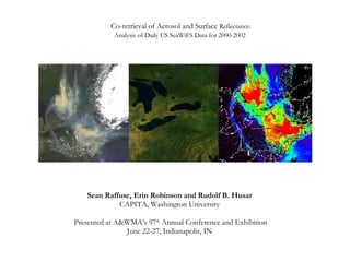
- 1. Co-retrieval of Aerosol and Surface Reflectance: Analysis of Daily US SeaWiFS Data for 2000-2002 Sean Raffuse, Erin Robinson and Rudolf B. Husar CAPITA, Washington University Presented at A&WMA’s 97 th Annual Conference and Exhibition June 22-27, Indianapolis, IN
- 4. Aerosol effects on surface color and Surface effects on aerosol color The image was synthesized from the blue (0.412 μm), green (0.555 μm), and red (0.67 μm) channels of the 8 channel SeaWiFS sensor. Air scattering has been removed to highlight the haze and surface reflectance.
- 13. Results – Seasonal surface reflectance, Eastern US April 29, 2000, Day 120 July 18, 2000, Day 200 October 16, 2000, Day 290
- 14. Results – Seasonal surface reflectance, Western US April 29, 2000, Day 120 July 18, 2000, Day 200 October 16, 2000, Day 290
- 15. Results – Eight month animation
- 18. July 10, 2002 July 9, 2002 July 8, 2002 July 7, 2002 July 6, 22002 July 5, 2002