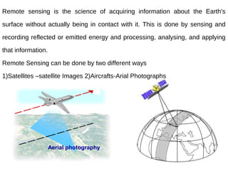
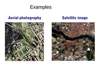
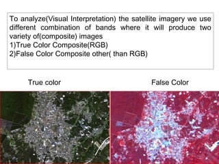
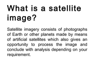
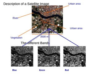
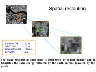
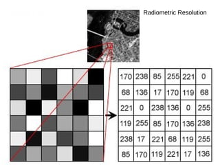
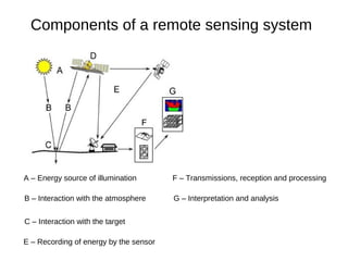
This document provides an overview of the fundamentals of remote sensing. It discusses that remote sensing involves acquiring information about the Earth's surface without direct contact through sensing and recording reflected or emitted energy. It describes how remote sensing can be done via satellites, which capture satellite images, and aircrafts, which capture aerial photographs. The document outlines different types of satellite images like true color composite and false color composite images. It also discusses key concepts in remote sensing like spatial resolution, radiometric resolution, spectral resolution, and components of a remote sensing system. Finally, it provides an overview of the electromagnetic spectrum and how the atmosphere can impact the quantity and quality of electromagnetic radiation captured by satellites.
A remote sensing system uses a detector to sense the reflected or emitted energy from the earth's surface, perhaps modified by the intervening atmosphere. The sensor can be on a satellite, aircraft, or drone. The sensor turns the energy into a voltage, which an analog to digital converter turns into a single integer value (called the Digital Number, or DN) for the energy. Alternatively a digital detector can store the DN directly. We can then display this value with an appropriate color to build up an image of the region sensed by the system. The DN represents the energy sensed by the sensor in a particular part of the electromagnetic spectrum, emitted or reflected from a particular region. The principles can also be applied to sonar imagery, especially useful in water where sound penetrates readily whereas electromagnetic energy attenuates rapidly.
Definitions,
Remote sensing systems can be active or passive: active systems put out their own source of energy (a large "flash bulb") whereas passive systems use solar energy reflected from the surface or thermal energy emitted by the surface. Active systems can achieve higher resolution.
Satellite resolution considers four things: spatial, spectral, radiometric, and temporal resolution.
Electromagnetic radiation and the atmosphere control many aspects of a remote sensing system.
Satellite orbits determine many characteristics of the imagery, what the satellite sees, and how often it revisits an area.
The signal to noise ratio is important for the design of remote sensing systems.
Satellite band tradeoffs.
Interpreting satellite reflectance patterns and images uses various statistical measures to assess surface properties in the image.
The colors used on the display are gray shading for single bands, and RGB for multi-band composites. We can also perform image merge and sharpening to combine the advantages of both panchromatic (higher spatial resolution) and color imagery (better differentiation of surface materials).
Keys for image analysis
Hyperspectral imagery
Spectral reflectance library--different materials reflect radiation differently
Types of Platforms
1. Airbrone Platforms
2. Spacebrone Platforms
Platforms are Vital Role in remote sensing data acquisition
Necessary to correct the position the remote sensors that collect data from the objects of interest
Radiometric corrections include correcting the data for sensor irregularities and unwanted sensor or atmospheric noise, and converting the data so they accurately represent the reflected or emitted radiation measured by the sensor.
This document help you to prepare Triangulation Network (TIN), Hillshade Map, Slope map, interpolation and Digital Elevation Model (DEM) in a area and how to interpret them.
What is Remote Sensing?
Process of Remote Sensing
Electromagnetic Radiations
Electromagnetic Spectrum
Interaction with Atmosphere
Radiations-Target Interactions
Passive Vs Active Sensing
IMAGE INTERPRETATION TECHNIQUES of surveyKaran Patel
Image interpretation is the process of examining an aerial photo or digital remote sensing image and manually identifying the features in that image. This method can be highly reliable and a wide variety of features can be identified, such as riparian vegetation type and condition, and anthropogenic features
APPLICATION OF REMOTE SENSING AND GIS IN AGRICULTURELagnajeetRoy
India is a country that depends on agriculture. Today in this era of technological supremacy, agriculture is also using different new technologies like some robotic machinery to remote sensing and Geographical Information System (GIS) for the betterment of agriculture. It is easy to get the information about that area where human cannot check the condition everyday and help in gathering the data with the help of remote sensing. Whereas GIS helps in preparation of map that shows an accurate representation of data we get through remote sensing. From disease estimation to stress factor due to water, from ground water quality index to acreage estimation in various way agriculture is being profited by the application of remote sensing and GIS in agriculture. The applications of those software or techniques are very new to the agriculture domain still much more exploration is needed in this part. New software’s are developing in different parts of the world and remote sensing. Today farmers understand the beneficiaries of these kinds of techniques to the farm field which help in increasing productivity that will help future generation as technology is hype in traditional system of farming.
This is all about remote sensing. Remote sensing is the acquisition of information about an object or phenomenon without making physical contact with the object and thus in contrast to on-site observation, especially the Earth.Remote sensing is the process of detecting and monitoring the physical characteristics of an area by measuring its reflected and emitted radiation at a distance from the targeted area. Special cameras collect remotely sensed imagesof the Earth, which help researchers "sense" things about the Earth.
Introduction to Remote Sensing- Remote sensing” is the science (and to some e...Ange Felix NSANZIYERA
"Remote sensing” is the science (and to some extent, art) of acquiring information about the Earth's surface without actually being in contact with it. This is done by sensing and recording reflected or emitted energy and processing, analyzing, and applying that information."
In much of remote sensing, the process involves an interaction between incident radiationand the targets of interest. This is exemplified by the use of imaging systems where thefollowing seven elements are involved. Note, however that remote sensing also involves thesensing of emitted energy and the use of non-imaging sensors.
physics of remote sensing,ideal remote sensing,swath,platform,sensor,orbit and its characteristics,electromagnetic radiations,EMR solar radiations and its application,shortwave and long waves,spectrul reflectance curve, resolution AND multi concept,FCC,
In the past two decades, there is a remarkable difference in the way life has evolved. I am a mid-80’s kid and proud to be one of them. There is huge difference between the present generation kids and our generation
You can do anything in 30 days. In this year be brave and try out something new. If you like and it
makes you feel good, keep it as a good habit. If you are not made for each other then try something
new!
A geographic information system (GIS) is a collection of hardware,
software, geographicdata, and personnel designed to create, store, edit,
manipulate, analyze and display geographically referenced information.
In this exercise you will explore ArcCatalog and learn how it is used within
the wider ArcGIS environment. You will practice the most important functions only. If necessary, additional functions will be introduced later in the course. First, you will familiarize with the interface, then with specific functions such as browsing and exploring data, creating metadata, etc. Finally you will learn that ArcCatalog can be used as a gateway to ArcMap.
ArcMap is ArcGIS’s desktop application for all map-based tasks, like data
and map analysis, editing and production of maps. In ArcMap, a user can
display data, make selections, analyse data, manipulate data, create data,
assign symbols and produce maps. ArcMap also serves as gateway to a
number of software extensions that perform specific tasks and analyses (extensions will be discussed later in the course).
Attraction is a strange thing which helps you in make things impossible to possible. A person can be perfectly handsome or beautiful, but if they are not attractive, their beauty can go unnoticed. Being attractive doesn't mean that we should be pretty
Transcript: Selling digital books in 2024: Insights from industry leaders - T...BookNet Canada
The publishing industry has been selling digital audiobooks and ebooks for over a decade and has found its groove. What’s changed? What has stayed the same? Where do we go from here? Join a group of leading sales peers from across the industry for a conversation about the lessons learned since the popularization of digital books, best practices, digital book supply chain management, and more.
Link to video recording: https://bnctechforum.ca/sessions/selling-digital-books-in-2024-insights-from-industry-leaders/
Presented by BookNet Canada on May 28, 2024, with support from the Department of Canadian Heritage.
Epistemic Interaction - tuning interfaces to provide information for AI supportAlan Dix
Paper presented at SYNERGY workshop at AVI 2024, Genoa, Italy. 3rd June 2024
https://alandix.com/academic/papers/synergy2024-epistemic/
As machine learning integrates deeper into human-computer interactions, the concept of epistemic interaction emerges, aiming to refine these interactions to enhance system adaptability. This approach encourages minor, intentional adjustments in user behaviour to enrich the data available for system learning. This paper introduces epistemic interaction within the context of human-system communication, illustrating how deliberate interaction design can improve system understanding and adaptation. Through concrete examples, we demonstrate the potential of epistemic interaction to significantly advance human-computer interaction by leveraging intuitive human communication strategies to inform system design and functionality, offering a novel pathway for enriching user-system engagements.
Securing your Kubernetes cluster_ a step-by-step guide to success !KatiaHIMEUR1
Today, after several years of existence, an extremely active community and an ultra-dynamic ecosystem, Kubernetes has established itself as the de facto standard in container orchestration. Thanks to a wide range of managed services, it has never been so easy to set up a ready-to-use Kubernetes cluster.
However, this ease of use means that the subject of security in Kubernetes is often left for later, or even neglected. This exposes companies to significant risks.
In this talk, I'll show you step-by-step how to secure your Kubernetes cluster for greater peace of mind and reliability.
Elevating Tactical DDD Patterns Through Object CalisthenicsDorra BARTAGUIZ
After immersing yourself in the blue book and its red counterpart, attending DDD-focused conferences, and applying tactical patterns, you're left with a crucial question: How do I ensure my design is effective? Tactical patterns within Domain-Driven Design (DDD) serve as guiding principles for creating clear and manageable domain models. However, achieving success with these patterns requires additional guidance. Interestingly, we've observed that a set of constraints initially designed for training purposes remarkably aligns with effective pattern implementation, offering a more ‘mechanical’ approach. Let's explore together how Object Calisthenics can elevate the design of your tactical DDD patterns, offering concrete help for those venturing into DDD for the first time!
JMeter webinar - integration with InfluxDB and GrafanaRTTS
Watch this recorded webinar about real-time monitoring of application performance. See how to integrate Apache JMeter, the open-source leader in performance testing, with InfluxDB, the open-source time-series database, and Grafana, the open-source analytics and visualization application.
In this webinar, we will review the benefits of leveraging InfluxDB and Grafana when executing load tests and demonstrate how these tools are used to visualize performance metrics.
Length: 30 minutes
Session Overview
-------------------------------------------
During this webinar, we will cover the following topics while demonstrating the integrations of JMeter, InfluxDB and Grafana:
- What out-of-the-box solutions are available for real-time monitoring JMeter tests?
- What are the benefits of integrating InfluxDB and Grafana into the load testing stack?
- Which features are provided by Grafana?
- Demonstration of InfluxDB and Grafana using a practice web application
To view the webinar recording, go to:
https://www.rttsweb.com/jmeter-integration-webinar
Connector Corner: Automate dynamic content and events by pushing a buttonDianaGray10
Here is something new! In our next Connector Corner webinar, we will demonstrate how you can use a single workflow to:
Create a campaign using Mailchimp with merge tags/fields
Send an interactive Slack channel message (using buttons)
Have the message received by managers and peers along with a test email for review
But there’s more:
In a second workflow supporting the same use case, you’ll see:
Your campaign sent to target colleagues for approval
If the “Approve” button is clicked, a Jira/Zendesk ticket is created for the marketing design team
But—if the “Reject” button is pushed, colleagues will be alerted via Slack message
Join us to learn more about this new, human-in-the-loop capability, brought to you by Integration Service connectors.
And...
Speakers:
Akshay Agnihotri, Product Manager
Charlie Greenberg, Host
State of ICS and IoT Cyber Threat Landscape Report 2024 previewPrayukth K V
The IoT and OT threat landscape report has been prepared by the Threat Research Team at Sectrio using data from Sectrio, cyber threat intelligence farming facilities spread across over 85 cities around the world. In addition, Sectrio also runs AI-based advanced threat and payload engagement facilities that serve as sinks to attract and engage sophisticated threat actors, and newer malware including new variants and latent threats that are at an earlier stage of development.
The latest edition of the OT/ICS and IoT security Threat Landscape Report 2024 also covers:
State of global ICS asset and network exposure
Sectoral targets and attacks as well as the cost of ransom
Global APT activity, AI usage, actor and tactic profiles, and implications
Rise in volumes of AI-powered cyberattacks
Major cyber events in 2024
Malware and malicious payload trends
Cyberattack types and targets
Vulnerability exploit attempts on CVEs
Attacks on counties – USA
Expansion of bot farms – how, where, and why
In-depth analysis of the cyber threat landscape across North America, South America, Europe, APAC, and the Middle East
Why are attacks on smart factories rising?
Cyber risk predictions
Axis of attacks – Europe
Systemic attacks in the Middle East
Download the full report from here:
https://sectrio.com/resources/ot-threat-landscape-reports/sectrio-releases-ot-ics-and-iot-security-threat-landscape-report-2024/
Smart TV Buyer Insights Survey 2024 by 91mobiles.pdf91mobiles
91mobiles recently conducted a Smart TV Buyer Insights Survey in which we asked over 3,000 respondents about the TV they own, aspects they look at on a new TV, and their TV buying preferences.
Accelerate your Kubernetes clusters with Varnish CachingThijs Feryn
A presentation about the usage and availability of Varnish on Kubernetes. This talk explores the capabilities of Varnish caching and shows how to use the Varnish Helm chart to deploy it to Kubernetes.
This presentation was delivered at K8SUG Singapore. See https://feryn.eu/presentations/accelerate-your-kubernetes-clusters-with-varnish-caching-k8sug-singapore-28-2024 for more details.
UiPath Test Automation using UiPath Test Suite series, part 3DianaGray10
Welcome to UiPath Test Automation using UiPath Test Suite series part 3. In this session, we will cover desktop automation along with UI automation.
Topics covered:
UI automation Introduction,
UI automation Sample
Desktop automation flow
Pradeep Chinnala, Senior Consultant Automation Developer @WonderBotz and UiPath MVP
Deepak Rai, Automation Practice Lead, Boundaryless Group and UiPath MVP
The Art of the Pitch: WordPress Relationships and SalesLaura Byrne
Clients don’t know what they don’t know. What web solutions are right for them? How does WordPress come into the picture? How do you make sure you understand scope and timeline? What do you do if sometime changes?
All these questions and more will be explored as we talk about matching clients’ needs with what your agency offers without pulling teeth or pulling your hair out. Practical tips, and strategies for successful relationship building that leads to closing the deal.
Dev Dives: Train smarter, not harder – active learning and UiPath LLMs for do...UiPathCommunity
💥 Speed, accuracy, and scaling – discover the superpowers of GenAI in action with UiPath Document Understanding and Communications Mining™:
See how to accelerate model training and optimize model performance with active learning
Learn about the latest enhancements to out-of-the-box document processing – with little to no training required
Get an exclusive demo of the new family of UiPath LLMs – GenAI models specialized for processing different types of documents and messages
This is a hands-on session specifically designed for automation developers and AI enthusiasts seeking to enhance their knowledge in leveraging the latest intelligent document processing capabilities offered by UiPath.
Speakers:
👨🏫 Andras Palfi, Senior Product Manager, UiPath
👩🏫 Lenka Dulovicova, Product Program Manager, UiPath
Encryption in Microsoft 365 - ExpertsLive Netherlands 2024Albert Hoitingh
In this session I delve into the encryption technology used in Microsoft 365 and Microsoft Purview. Including the concepts of Customer Key and Double Key Encryption.
Slack (or Teams) Automation for Bonterra Impact Management (fka Social Soluti...Jeffrey Haguewood
Sidekick Solutions uses Bonterra Impact Management (fka Social Solutions Apricot) and automation solutions to integrate data for business workflows.
We believe integration and automation are essential to user experience and the promise of efficient work through technology. Automation is the critical ingredient to realizing that full vision. We develop integration products and services for Bonterra Case Management software to support the deployment of automations for a variety of use cases.
This video focuses on the notifications, alerts, and approval requests using Slack for Bonterra Impact Management. The solutions covered in this webinar can also be deployed for Microsoft Teams.
Interested in deploying notification automations for Bonterra Impact Management? Contact us at sales@sidekicksolutionsllc.com to discuss next steps.
2. Remote sensing is the science of acquiring information about the Earth's
surface without actually being in contact with it. This is done by sensing and
recording reflected or emitted energy and processing, analysing, and applying
that information.
Remote Sensing can be done by two different ways
1)Satellites –satellite Images 2)Aircrafts-Arial Photographs
Satellite image
Aerial photography
4. To analyze(Visual Interpretation) the satellite imagery we use
different combination of bands where it will produce two
variety of(composite) images
1)True Color Composite(RGB)
2)False Color Composite other( than RGB)
True color False Color
7. What is a satellite
image?
Satellite imagery consists of photographs
of Earth or other planets made by means
of artificial satellites which also gives an
opportunity to process the image and
conclude with analysis depending on your
requirement.
8. Description of a Satellite Image Urban area
River
Urban area
Vegetation 3500 m
The different Bands
Blue Green Red
9. Spatial resolution
23
40
Landsat TM 30 m 10
SPOT XS 10 m 70
NOAA/AVHRR 1100 m
120
IKONOS 4m
The value retained in each pixel is designated by digital number and it
translates the solar energy reflected by the earth surface (covered by the
pixel).
12. Blue Gree Red Spectral Resolution
TM 1 nTM 2 TM 3
Near Infrared Middle Infrared Middle Infrared
TM 4 TM 5 TM
7
432
743
13. Components of a remote sensing system
A – Energy source of illumination F – Transmissions, reception and processing
B – Interaction with the atmosphere G – Interpretation and analysis
C – Interaction with the target
E – Recording of energy by the sensor
14. v = frequency
(number of cycles per second
passing a fixed point)
Wavelength is measured in meters (m) or some factor of meters such as nanometres
(nm, 10-9 m), micrometers (μm, 10-6 m) or centimeters (cm, 10-2 m).
Frequency is normally measured in hertz (Hz), equivalent to one cycle per second, and
various multiples of hertz.
15. Quantity of radiant energy is expressed in energy units.
Quality of radiant energy is characterised by frequency
(u) or wavelength (l).
c=lu
c - velocity of light (3x10⁸m/s)
Wavelength and frequency are inversely related to each
other:
• the shorter the wavelength, the higher the
frequency;
• the longer the wavelength, the lower the frequency.
16.
17. Electromagnetic spectrum
The electromagnetic spectrum is the range of all
possible frequencies of electromagnetic
radiation.* The "electromagnetic spectrum" of an
object has a different meaning, and is instead the
characteristic distribution of electromagnetic
radiation emitted or absorbed by that particular
object.
*The energy in remote sensing is in the form of
electromagnetic radiation.Electro magnetic Radiation is
a particular form of energy emitted and absorbed by
charged particles
18.
19. The visible portion of the spectrum is a
very small part of the whole spectrum:
•blue - 0.4 a 0.5 mm
•green - 0.5 a 0.6 mm
•red - 0.6 a 0.7 mm.
1 mm = 10-6 m
The wavelengths smaller than 0.4
mm entails:
• gamma rays
• x rays
• ultraviolet radiation
20. The part of the electromagnetic spectrum with
wavelengths larger than 0.7 mm entails:
• infrared (0.7-10 mm),
• microwaves (1mm-1m)
• radio waves.
Infrared goes from 0.7 mm to 10 mm and can
be divided in three areas:
• Near infrared (0.7-1.0 mm),
• medium infrared (1.3-3.0 mm)
• thermal infrared (> 3 mm).
21. Interaction of electromagnetic radiation
with atmosphere
The atmosphere has a strong effect on the quantity
and quality of the electromagnetic radiation captured
by the satellite.
The atmosphere effect varies with:
• radiation path (airplane, satellite)
• wavelength
• atmospheric conditions (particles, gases, …)
• ...
22. Before radiation used for remote sensing reaches the
Earth's surface it has to travel through some distance of
the Earth's atmosphere.
Particles and gases in the atmosphere can affect the
incoming light and radiation. These effects are caused
by the mechanisms of:
• scattering
• absorption.
What is the effect of atmosphere in the satellite
images?
• Atmosphere reduces contrast
• Atmosphere may blur the images
• Atmospheres may reduce the quantity of
radiation