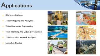
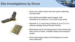
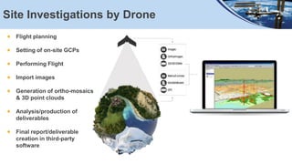
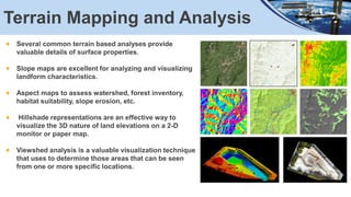
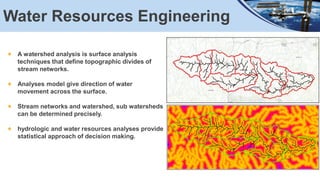
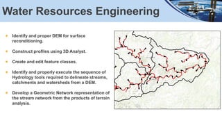
This document summarizes geospatial applications in civil engineering. It discusses how remote sensing and GIS techniques can be used for site investigations, terrain mapping and analysis, water resources engineering, town planning and urban development, transportation network analysis, and landslide studies. Specific applications are described, including using drones for site investigations, terrain analysis tools like slope and aspect maps, watershed and hydrologic modeling, and urban planning. Data sources, tools, and workflows are also outlined.
identification of ground water potential zones using gis and remote sensingtp jayamohan
the identification of ground water potential zones using gis and remote sensing.The study is conducted in the Muvattupuzha block.The various parameters used are geology,geomorphology,rainfall,soil type,etc.
Applications of GIS in Municipal Solid Waste ManagementVignesh Sekar
Geographic Information System (GIS) is used to input, store, retrieve, manipulate, analyze and output geographically referenced data. In order to support decision making for planning and management of land use, natural resources, environment, transportation, urban facilities, and other administrative records.The Role of GIS is very large as many aspects of its planning and operations are highly dependent on spatial data & also provides a digital data bank for future monitoring program of the site…….etc
This document help you to prepare Triangulation Network (TIN), Hillshade Map, Slope map, interpolation and Digital Elevation Model (DEM) in a area and how to interpret them.
DEFINITION :
GIS is a powerful set of tools for collecting, storing , retrieving at will, transforming and displaying spatial data from the real world for a particular set of purposes
APPLICATION AREAS OF GIS
Agriculture
Business
Electric/Gas utilities
Environment
Forestry
Geology
Hydrology
Land-use planning
Local government
Mapping
11. Military
12. Risk management
13. Site planning
14. Transportation
15. Water / Waste water industry
COMPONENTS OF GIS
DATA INPUT
SPATIAL DATA MODEL
Data Model:
It describes in an abstract way how the data is represented in an information system or in DBMS
Spatial Data Model :
The models or abstractions of reality that are intended to have some similarity with selected aspects of the real world
Creation of analogue and digital spatial data sets involves seven levels of model development and abstraction
SPATIAL DATA MODEL
Conceptual model : A view of reality
Analog model : Human conceptualization leads to analogue abstraction
Spatial data models : Formalization of analogue abstractions without any conventions
Database model : How the data are recorded in the computer
Physical computational model : Particular representation of the data structures in computer memory
Data manipulation model : Accepted axioms and rules for handling the data
SPATIAL DATA MODEL
SPATIAL DATA MODEL
Objects on the earth surface are shown as continuous and discrete objects in spatial data models
Types of data models
Raster data model
vector data models
RASTER DATA MODEL
Basic Elements :
Extent
Rows
Columns
Origin
Orientation
Resolution: pixel = grain = grid cell
Ex: Bit Map Image (BMP),Joint Photographic Expert Group (JPEG), Portable Network Graphics(PNG) etc
RASTER DATA MODEL
VECTOR DATA MODEL
Basic Elements:
Location (x,y) or (x,y,z)
Explicit, i.e. pegged to a coordinate system
Different coordinate system (and precision) require different values
o e.g. UTM as integer (but large)
o Lat, long as two floating point numbers +/-
Points are used to build more complex features
Ex: Auto CAD Drawing File(DWG), Data Interchange(exchange) File(DXF), Vector Product Format (VPF) etc
VECTOR DATA MODEL
RASTER vs VECTORRaster is faster but Vector is corrector
TESSELLATIONS OF CONTINUOUS FIELDS
Triangular Irregular Network: (TIN)
TIN is a vector data structure for representing geographical information that is continuous
Digital elevation model
TIN is generally used to create Digital Elevation Model (DEM)
DIGITAL ELEVATION MODEL
DATA STRUCTURES
Data structure tells about how the data is stored
Data organization in raster data structures
Each cell is referenced directly
Each overlay Is referenced directly
Each mapping unit is referenced directly
Each overlay is separate file with general header
A network is a system of interconnected elements, such as edges (lines) and connecting junctions (points), that represent possible routes from one location to another.
Here I explained introduction to the network analysis in GIS.
Conference poster In 5th International Conference on PErvasive Technologies Related to Assistive Environments (PETRA), Hersonissos, Crete (GR), June 6-8, 2012
Geospatial Data and Key Characteristics of Geospatial Data Analysis and ScienceLuis Bermudez
The growing complexity and interdisciplinarity of research and applied science questions requires the developments of standards to exchange data within continuously growing communities as well as across domains. In most domains, geo-spatial data is the fundamental base layer for data science and analysis, as the vast majority have some spatial characteristics or apply to elements in space. Using the available standards, a good level of interoperability can already be realized. Nevertheless, the increasing complexity of research questions, the growing number of available data, and the increasing range of data providers, ranging from citizen scientists to fully automated sensor networks making their data directly available at the Internet, require even richer models that need to be developed to enhance the level of interoperability.
National level strategy for Open Principles in GeospatialSuchith Anand
This session at FOSS4G UK conference 2016 at the Ordnance Survey UK is aims to start the process of bringing together interested participants from government, industry and academia to discuss ideas on best practices in open source geospatial implementations, open data, open standards, opportunities for geo industry, migration to open source GIS ,economic benefits, accelerating innovation ecosystems , skills development and educational opportunities, creating highly skilled jobs, expanding startups and accelerating the digital economy. There is a need for having a national level strategy for enabling the public sector to save money, innovate and make more effective policy decisions.
IMGS Geospatial User Group 2014: Hexagon Geospatial Vision, Mission and StrategyIMGS
Fusing the Real and Digital Worlds i.e. the world we live in and its digital reflection.
We need to close the productivity gap in order to increase efficiency and productivity.
The world is not build of single customers but of ecosystems that integrate technology between sectors and so gain synergies. Hexagon offers the possibility to use smart data to make smart decisions.
An overview of Docker and Linux containers. There are three parts:
An introduction to Docker and containers
A demo that the audience can try out
An overview of the various vendors and groups in this space
The demo is meant to be a simple, step-by-step recipe that introduces the basic commands and ends by spinning up a node.js app using two linked containers: node and redis.
The final section explores the companies and groups that are working on containers, either complementing Docker's contributions or in direct competition with them.
Docker Container Lifecycles, Problem or Opportunity? by Baruch Sadogursky, JFrogDocker, Inc.
Docker is hot. However, as Docker container use spreads into more mature production pipelines, there can be issues about control of Docker images to ensure they are production-ready. Is a promotion-based model appropriate to control and track the flow of Docker images from development to production? We will demonstrate how to implement a promotion model for docker images, and then show how to distribute them to any kind of consumer, being it a customer or a data center.
Geospatial technology is about using a range of modern tools used for geographic mapping and analysis of the earth & human societies. We keep Information & Technology at the core of all our offerings
Surveying for Civil engineering is a
particular type of surveying known as "land surveying", it is the
detailed study or inspection, as by gathering information through
observations, measurements in the field, questionnaires, or
research of legal instruments, and data analysis in the support of
planning, designing, and establishing of property boundaries.
Land surveying can include associated services such as mapping
and related data accumulation, construction layout surveys,
precision measurements of length, angle, elevation, area, and
volume, as well as horizontal and vertical control surveys, and
the analysis and utilization of land survey data. Surveyors use
various tools to do their work successfully and accurately, such
as total stations, robotic total stations, GPS receivers, prisms, 3D
scanners, radio communicators, handheld tablets, digital levels,
and surveying software.
Survey data can be directly entered into a GIS from digital
data collection systems on survey instruments. When data is
captured, the user should consider if the data should be captured
with either a relative accuracy or absolute accuracy, since this
could not only influence how information will be interpreted but
also the cost of data captured.
In this paper GIS maps were developed depending on the
field surveying data made for a two traverses. First one has ribs
less than 50m length and the other larger than 50m. Each
traverse is holding five times using five equipments and
instruments: Tape, Level, Digital level, Digital theodolite and
Laser tape. Also those maps were drawn by using both of ACAD
and ArcView softwares. Then a detail surveying map was
produced. The precision was computed for both traverses in each
method. Its value is range from 1/140 to 1/10000.
Use of Satellite Data for Feasibility Study And Preliminary Design Project Re...IJERDJOURNAL
ABSTRACT: In the developing countries like India, need of infrastructure is very high as compared to the available resources. The various organizations put their demands to state and center government for sanction of their project, government depends upon its various department to provide an approximate cost so that priorities can be assigned. The conventional procedure depends upon the land surveying, collection of data from various departments resulting in delay in necessary decision making or some time shelving due to unreasonable cost estimate due to field data being very old. Survey of India, The National Survey and Mapping Organization single handily taking this responsibility thus up gradation of data is far behind the actual development. From the satellite data, which is available in the form of images and terrains (even in 3d LiDAR points for some areas) is very useful for Feasibility Study, and Preliminary Project Report. In the present study natural drain named „Chai Nala‟ meanders through the prime property of Greater Mohali Area Development Authority (GMADA) thus making a big chunk of commercial land inoperative. It was proposed to straighten and channelize to reclaim the land from drain regime. Being the precious land department wanted the most economical and technically sound design without taking any risk. It was decided to counter check the hydraulic data, ground profile, acquired from the Punjab Irrigation Department with the satellite data and Differential Global Positioning System (DGPS). The data from the Google Earth was acquired using Cad Earth software and water shed analysis was carried out using Autodesk Civil 3D software. Comparison of results shows that this technique is quite useful and can be for preliminary feasibility and project preparation. Thus saving huge money and time.
Technological advances have created efficiencies in both land and topographical surveying. Total stations, satellite positioning systems, GIS software and 3D scanners have advanced the capabilities of surveying. Municipalities benefit from these advances with reduction in staffing needs; creation of safer and quicker processes; and production of more precise work.
Topographic Information System as a Tool for Environmental Management, a Case...iosrjce
IOSR Journal of Environmental Science, Toxicology and Food Technology (IOSR-JESTFT) multidisciplinary peer-reviewed Journal with reputable academics and experts as board member. IOSR-JESTFT is designed for the prompt publication of peer-reviewed articles in all areas of subject. The journal articles will be accessed freely online.
Similar to Geospatial Applications in Civil Engineering (20)
About
Indigenized remote control interface card suitable for MAFI system CCR equipment. Compatible for IDM8000 CCR. Backplane mounted serial and TCP/Ethernet communication module for CCR remote access. IDM 8000 CCR remote control on serial and TCP protocol.
• Remote control: Parallel or serial interface.
• Compatible with MAFI CCR system.
• Compatible with IDM8000 CCR.
• Compatible with Backplane mount serial communication.
• Compatible with commercial and Defence aviation CCR system.
• Remote control system for accessing CCR and allied system over serial or TCP.
• Indigenized local Support/presence in India.
• Easy in configuration using DIP switches.
Technical Specifications
Indigenized remote control interface card suitable for MAFI system CCR equipment. Compatible for IDM8000 CCR. Backplane mounted serial and TCP/Ethernet communication module for CCR remote access. IDM 8000 CCR remote control on serial and TCP protocol.
Key Features
Indigenized remote control interface card suitable for MAFI system CCR equipment. Compatible for IDM8000 CCR. Backplane mounted serial and TCP/Ethernet communication module for CCR remote access. IDM 8000 CCR remote control on serial and TCP protocol.
• Remote control: Parallel or serial interface
• Compatible with MAFI CCR system
• Copatiable with IDM8000 CCR
• Compatible with Backplane mount serial communication.
• Compatible with commercial and Defence aviation CCR system.
• Remote control system for accessing CCR and allied system over serial or TCP.
• Indigenized local Support/presence in India.
Application
• Remote control: Parallel or serial interface.
• Compatible with MAFI CCR system.
• Compatible with IDM8000 CCR.
• Compatible with Backplane mount serial communication.
• Compatible with commercial and Defence aviation CCR system.
• Remote control system for accessing CCR and allied system over serial or TCP.
• Indigenized local Support/presence in India.
• Easy in configuration using DIP switches.
Forklift Classes Overview by Intella PartsIntella Parts
Discover the different forklift classes and their specific applications. Learn how to choose the right forklift for your needs to ensure safety, efficiency, and compliance in your operations.
For more technical information, visit our website https://intellaparts.com
Water scarcity is the lack of fresh water resources to meet the standard water demand. There are two type of water scarcity. One is physical. The other is economic water scarcity.
Quality defects in TMT Bars, Possible causes and Potential Solutions.PrashantGoswami42
Maintaining high-quality standards in the production of TMT bars is crucial for ensuring structural integrity in construction. Addressing common defects through careful monitoring, standardized processes, and advanced technology can significantly improve the quality of TMT bars. Continuous training and adherence to quality control measures will also play a pivotal role in minimizing these defects.
Industrial Training at Shahjalal Fertilizer Company Limited (SFCL)MdTanvirMahtab2
This presentation is about the working procedure of Shahjalal Fertilizer Company Limited (SFCL). A Govt. owned Company of Bangladesh Chemical Industries Corporation under Ministry of Industries.
Immunizing Image Classifiers Against Localized Adversary Attacksgerogepatton
This paper addresses the vulnerability of deep learning models, particularly convolutional neural networks
(CNN)s, to adversarial attacks and presents a proactive training technique designed to counter them. We
introduce a novel volumization algorithm, which transforms 2D images into 3D volumetric representations.
When combined with 3D convolution and deep curriculum learning optimization (CLO), itsignificantly improves
the immunity of models against localized universal attacks by up to 40%. We evaluate our proposed approach
using contemporary CNN architectures and the modified Canadian Institute for Advanced Research (CIFAR-10
and CIFAR-100) and ImageNet Large Scale Visual Recognition Challenge (ILSVRC12) datasets, showcasing
accuracy improvements over previous techniques. The results indicate that the combination of the volumetric
input and curriculum learning holds significant promise for mitigating adversarial attacks without necessitating
adversary training.
CFD Simulation of By-pass Flow in a HRSG module by R&R Consult.pptxR&R Consult
CFD analysis is incredibly effective at solving mysteries and improving the performance of complex systems!
Here's a great example: At a large natural gas-fired power plant, where they use waste heat to generate steam and energy, they were puzzled that their boiler wasn't producing as much steam as expected.
R&R and Tetra Engineering Group Inc. were asked to solve the issue with reduced steam production.
An inspection had shown that a significant amount of hot flue gas was bypassing the boiler tubes, where the heat was supposed to be transferred.
R&R Consult conducted a CFD analysis, which revealed that 6.3% of the flue gas was bypassing the boiler tubes without transferring heat. The analysis also showed that the flue gas was instead being directed along the sides of the boiler and between the modules that were supposed to capture the heat. This was the cause of the reduced performance.
Based on our results, Tetra Engineering installed covering plates to reduce the bypass flow. This improved the boiler's performance and increased electricity production.
It is always satisfying when we can help solve complex challenges like this. Do your systems also need a check-up or optimization? Give us a call!
Work done in cooperation with James Malloy and David Moelling from Tetra Engineering.
More examples of our work https://www.r-r-consult.dk/en/cases-en/
TECHNICAL TRAINING MANUAL GENERAL FAMILIARIZATION COURSEDuvanRamosGarzon1
AIRCRAFT GENERAL
The Single Aisle is the most advanced family aircraft in service today, with fly-by-wire flight controls.
The A318, A319, A320 and A321 are twin-engine subsonic medium range aircraft.
The family offers a choice of engines
2. Agenda
Introduction about Remote Sensing and GIS
Geospatial Applications In Civil Engineering
Data, Tools & Workflow
Data Accessibility
3. Remote sensing observations provide data on earth’s surface objects in a
spatial format and it has the advantage of synoptic view and large area
coverage.
This Spatial data can be efficiently handled using Geographic Information
System (GIS) and its also allows data integration.
In civil engineering projects, RS and GIS techniques became potential and
necessary tools.
Introduction
4. Site Investigations
Terrain Mapping and Analysis
Water Resources Engineering
Town Planning And Urban Development
Transportation Network Analysis
Landslide Studies
Applications
5. Site Investigations by Drone
Drone can vastly reduce the time spent collecting
accurate data
Geo-referenced digital aerial images, with
resolutions as sharp as 1.5 cm (0.6 in) per pixel.
Absolute X, Y, Z accuracy of down to 3 cm (1.2 in) –
without needing Ground Control Points.
Minimizing risk to surveying teams when measuring
sites such as mines, unstable slopes and transport
routes.
Drone technology allows Civil Engineers to work
more efficiently
6. Site Investigations by Drone
Flight planning
Setting of on-site GCPs
Performing Flight
Import images
Generation of ortho-mosaics
& 3D point clouds
Analysis/production of
deliverables
Final report/deliverable
creation in third-party
software
7. Terrain Mapping and Analysis
Several common terrain based analyses provide
valuable details of surface properties.
Slope maps are excellent for analyzing and visualizing
landform characteristics.
Aspect maps to assess watershed, forest inventory,
habitat suitability, slope erosion, etc.
Hillshade representations are an effective way to
visualize the 3D nature of land elevations on a 2-D
monitor or paper map.
Viewshed analysis is a valuable visualization technique
that uses to determine those areas that can be seen
from one or more specific locations.
8. Water Resources Engineering
A watershed analysis is surface analysis
techniques that define topographic divides of
stream networks.
Analyses model give direction of water
movement across the surface.
Stream networks and watershed, sub watersheds
can be determined precisely.
hydrologic and water resources analyses provide
statistical approach of decision making.
9. Water Resources Engineering
Identify and proper DEM for surface
reconditioning.
Construct profiles using 3D Analyst.
Create and edit feature classes.
Identify and properly execute the sequence of
Hydrology tools required to delineate streams,
catchments and watersheds from a DEM.
Develop a Geometric Network representation of
the stream network from the products of terrain
analysis.
10. Town Planning & Urban Development
Easy management of housing, sanitation, power, water supply, disposal of
effluents and environmental pollution.
Optimal master plan for development and management of urban settlements
can be prepared.
Monitoring of urban land use changes and future planning, management and
policy making.
11. Data, Tools & Workflow
1. Find suitable locations for School or Collage By combining spatial data, find
areas that are the most suitable, such as siting a new building or determining
high-risk areas for flooding or landslides.
2. Calculate low cost of travel path surfaces to identify optimum corridors, in
economic and environmental conditions with other objectives.
3. Watershed and stream network delineation based on digital elevation models
using the Hydrology tools in the Geoprocessing toolbox.