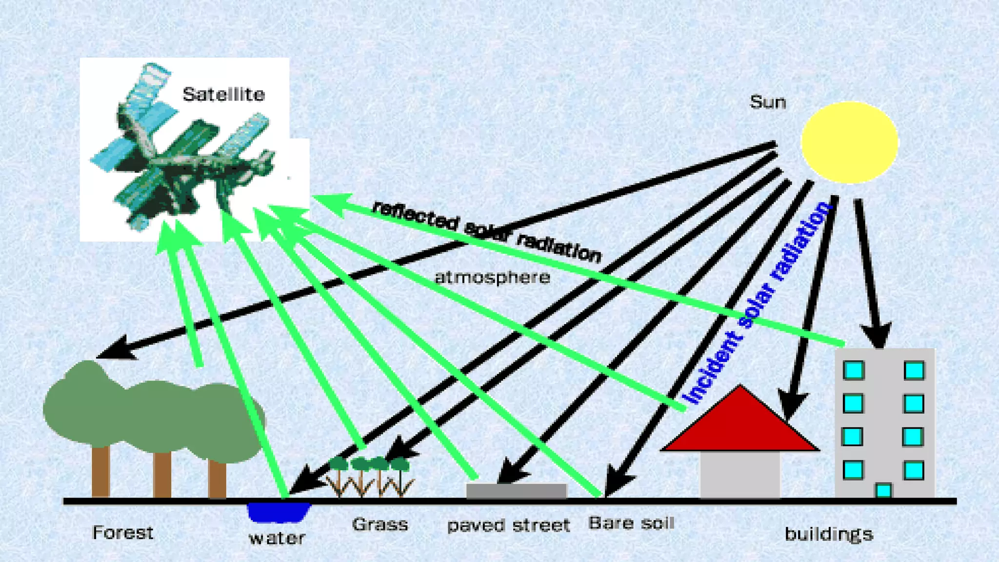
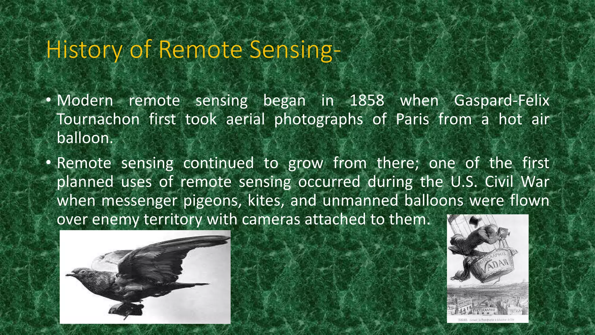
Presentation on Remote Sensing. This presentation is very short and simple and is very easy to understand you .all the best for your future
with regards- Harvendra singh
Remote sensing involves collecting information about an object or area without physical contact using devices like satellites and aircraft. There are two main types: passive sensing which detects natural radiation like sunlight, and active sensing which emits energy like radar. The first weather satellite, TIROS-1, was launched in 1960 and used cameras to scan wide areas, revolutionizing remote sensing. Satellites provide an extended view of Earth and allow data collection in dangerous or inaccessible places without disturbing the environment. Remote sensing is used in fields like natural resource management and agriculture.
This document discusses remote sensing and meteorology. It defines remote sensing as obtaining information about physical objects through non-contact sensors. Meteorology is the study of atmospheric phenomena like weather. Meteorological satellites and weather radars are important tools for monitoring weather. Satellites provide global coverage of cloud patterns and weather systems from space. They capture visible, infrared, and water vapor images to study cloud formations, temperatures, and moisture in the atmosphere. Radar emits microwaves that bounce off water droplets in clouds to measure precipitation and cloud locations. Satellite weather monitoring improves forecasts, especially over oceans with sparse weather station data.
The document discusses the use of meteorological satellites, weather balloons, and sounding rockets for weather forecasting. It provides background on severe weather events that have caused major damage, highlighting the need for improved forecasting. It then describes some of the first meteorological satellites, including TIROS-1, which was the first to transmit cloud photos from space. It also discusses the NIMBUS satellites, which had improved coverage over the TIROS satellites and helped enable long-term observations of phenomena like the ozone hole.
Remote sensing involves acquiring information about the Earth's surface from a distance, without direct contact, by sensing and recording reflected or emitted energy and processing the data. It uses artificial sensors, either active sensors that emit their own illumination source or passive sensors that detect naturally available sunlight or thermal radiation. The remote sensing process involves an energy source, interaction with the atmosphere and target, recording by a sensor, transmission and processing of the data, interpretation and analysis to extract information, and application of the results. Some key applications of remote sensing include agriculture, mapping land use and cover changes, ocean monitoring, and environmental and disaster management.
This document discusses satellite communication and the different types of satellite orbits. It provides details on some of the key events and innovations in satellite technology. The three main types of orbits discussed are low Earth orbit (LEO), medium Earth orbit (MEO), and geostationary Earth orbit (GEO). LEO satellites orbit closer to Earth while GEO satellites orbit at an altitude that matches Earth's rotation so they remain stationary over one position. The document also summarizes how satellites are used to relay communications between two ground stations on Earth.
Meteorology is a discipline concerned with observational earth sciences and theoretical physics. It has the task of providing an accurate knowledge of the state of the atmosphere. Before the advent of weather satellites the weathermen had been severely handicapped by having only a very limited knowledge of the state of the atmosphere at any given time. Meteorological satellites have to a large extent has enabled to overcome this deficiency.
Remote sensing involves obtaining information about objects through analysis of data collected by instruments without physical contact. It uses electromagnetic radiation as a physical carrier to transmit information from objects to sensors through an intervening medium. The output is usually an image representing the observed scene. Remote sensing has a long history dating back to the 1840s with cameras on balloons, and emerged in the 1950s as a technique using various sensors on spacecraft. It involves an energy source, radiation interaction with the object, sensor recording, transmission and processing, interpretation and applications. Active sensors use artificial sources while passive sensors rely on natural sources like the sun. Platforms include ground, airborne and spaceborne. Applications are in meteorology, oceanography, geology, agriculture,
Remote sensing involves collecting information about objects without physical contact. It was first defined in the 1960s and the first earth observation satellite, Landsat-1, was launched in 1972. Remote sensing uses sensors on airborne and spaceborne platforms to detect electromagnetic radiation reflected or emitted from the object of interest. Common platforms include aircraft, balloons, and satellites. Satellites provide global coverage and frequent revisits. Remote sensing data has various applications such as agriculture, forestry, and soil mapping.
This document provides an overview of a seminar on remote sensing, GIS and their application for soil fertility mapping. It introduces remote sensing concepts like passive and active sensing, platforms like aircraft and satellites, and multispectral sensors. It discusses how GIS organizes geographic data and examples of data sources. The document presents a case study that mapped soil properties in Mathura District, India using remote sensing and GIS techniques. It describes the digitizing process in ArcGIS and studies on mapping clay minerals and soil contamination with spectroscopy. The document concludes that remote sensing and GIS can efficiently map large areas to aid in crop selection and productivity.
Optical and Microwave Remote Sensing for Crop Monitoring in MexicoCIMMYT
Remote sensing –Beyond images
Mexico 14-15 December 2013
The workshop was organized by CIMMYT Global Conservation Agriculture Program (GCAP) and funded by the Bill & Melinda Gates Foundation (BMGF), the Mexican Secretariat of Agriculture, Livestock, Rural Development, Fisheries and Food (SAGARPA), the International Maize and Wheat Improvement Center (CIMMYT), CGIAR Research Program on Maize, the Cereal System Initiative for South Asia (CSISA) and the Sustainable Modernization of the Traditional Agriculture (MasAgro)
This document provides an overview of remote sensing. It defines remote sensing as acquiring information about objects from a distance using sensors, without direct contact. Remote sensing occurs from various platforms, including ground, airplanes, and satellites. The history of remote sensing is discussed, beginning with aerial photography in 1909 and expanding to use of satellites, hyperspectral imaging, and more advanced technologies. A variety of applications of remote sensing are outlined, including uses in agriculture, forestry, geology, hydrology, land cover/land use mapping, and addressing national priorities such as disaster management and energy management.
Remote sensing is the science of obtaining information about objects through analysis of sensor data without physical contact. Electromagnetic radiation is used for remote sensing and propagates as waves through the electromagnetic spectrum. Platforms for remote sensing include ground, aerial, and space-based sensors. Spaceborne sensors on satellites provide large area coverage at regular intervals. Common satellite sensors discussed are Cartosat, RISAT, MODIS, and ASTER.
Remote Sensing - A tool of plant disease managementAnand Choudhary
The document provides an overview of remote sensing in plant pathology. It discusses the history and fundamentals of remote sensing, including different types of platforms, resolutions, and the objectives and case studies of remote sensing in plant disease management. Key objectives of remote sensing in plant pathology include assessing diseases over large areas, understanding disease-environment relationships, detecting and identifying plant diseases, and aiding disease management. Case studies demonstrate uses of remote sensing for various crop diseases.
Remote sensing and its applications in environmentMuhammad Sajjad
This document provides an overview of remote sensing including its history, sensors, platforms, applications, software, and use in Pakistan. Remote sensing allows obtaining information about objects through analysis of data collected by instruments without physical contact. It uses electromagnetic radiation as an information carrier. Common sensors are active like LIDAR and RADAR, or passive. Platforms include ground, airborne, and spaceborne. Applications span meteorology, oceanography, geology, agriculture, and more. Popular software for analysis includes ERDAS, ENVI, and ESRI. Pakistan is developing its own remote sensing satellite called PRSS and using the technology to improve flood management.
Remote sensing uses sensors on satellites and aircraft to measure electromagnetic radiation from the Earth's surface. This data can be used to support fisheries and aquaculture management by providing information on sea surface temperature, ocean color, ocean salinity, land cover, and the location of coastal aquaculture structures over large geographic areas. A case study demonstrated how satellite images could map fish ponds and cages in a coastal region of the Philippines. Remote sensing will continue playing an important role in monitoring fisheries and aquaculture by providing global and repeated observations in a cost-effective manner.
Indian remote sensing satellite,potentials with a revolutionSamikshya Kar
Indian Remote Sensing satellites provide remote sensing services to India. Data from these satellites are used for various applications like crop production estimation, drought monitoring, land use mapping, and more. The Cartosat-1 satellite has panchromatic cameras with a spatial resolution of 2.5 meters. It collects data that is processed and analyzed to derive information about vegetation, water bodies, and other landscape features with various applications such as malaria risk mapping. Remote sensing technologies allow analyzing large regions from space and measuring energy beyond human vision to enable global monitoring.
All the information, facts, statements, figures, and other data used in this presentation are collected from different internet sources and literature. The sources of data are appropriately disclosed in all the slides or in reference. The data was used for education purposes only.
Also, I do not claim ownership/copyright of any image that has been obtained from the public domain and literature. I have acknowledged sources of all the information as much as possible.
The educator/student can use this presentation for education/learning purposes by acknowledging the sources of the data being used in this presentation.
Thank you.
Remote sensing involves obtaining information about objects through sensors without direct contact. It has applications in many fields including urban planning, agriculture, forestry, and land use mapping. Some key information obtained from remote sensing includes crop acreage, forest resource mapping, flood damage assessment, and monitoring of changes over time. Advantages include rapid information updating, infrastructure monitoring, and improved decision making for management and planning.
Remote sensing involves collecting data about objects from a distance without direct contact. It works by measuring reflected electromagnetic energy from targets using sensors on platforms like satellites. There are several key components, including the energy source (sun), its interaction with the atmosphere and earth surfaces, sensors to record the energy, and processing of the data. Remote sensing provides digital imagery that can be analyzed for applications like land use mapping. Global positioning systems (GPS) provide location data by triangulating signals from satellite constellations. India is developing its own regional GPS network called IRNSS and has also launched satellites for other countries to gain experience in space technologies.
Remote sensing history and its application in Pakistan GCUF
Remote sensing involves obtaining information about objects through analysis of data collected by instruments without physical contact. The history of remote sensing began with the camera obscura and photography in the 1800s. It has since involved various platforms including balloons, aircraft, rockets and satellites. The process involves energy source, atmosphere interaction, sensor recording, processing and analysis. Applications include meteorology, oceanography, geology, agriculture, hydrology and disaster management. Pakistan is developing its own remote sensing satellite and using the technology to improve flood management.
A presention on remote sensing & its application (1)Ankit Singh
This document discusses remote sensing, which involves acquiring information about Earth's surface using sensors from a distance. Key points covered include:
- Remote sensing uses reflected or emitted electromagnetic energy to determine characteristics of objects without physical contact.
- Data is collected by sensors on various platforms including aircraft and satellites. This remotely sensed data is then processed and analyzed.
- It is used in applications like agriculture, land use, geology, and environmental monitoring.
Remote sensing is a method of obtaining information about an object without physical contact. It involves capturing electromagnetic radiation reflected or emitted from the Earth's surface using sensors on satellites or aircraft. Satellites provide global coverage and allow monitoring of large areas over time. Data from remote sensing is used for applications like monitoring weather, climate change, agriculture, forestry, geology and more. It provides valuable data efficiently but requires expert analysis and may lack detail.
Element Of Civil Engineering and surveying subject as per GTU syllabus 1st sem carry out all content. also usefull for general idea about civil branch.
The document summarizes key aspects of pest surveillance using remote sensing and GIS techniques. It discusses pest surveillance methods like roving surveys and fixed plot surveys to monitor pest populations. It also describes using remote sensing from different platforms like ground-based, airborne and spaceborne sensors to collect spectral data on crop health and pest stress. GIS is used to store spatial data collected through remote sensing and surveillance that can help with pest management and decision making.
Remote sensing involves acquiring information about the Earth's surface without direct contact using sensors to detect electromagnetic radiation. There are 7 steps in the remote sensing process: illumination, interaction with the atmosphere, interaction with the target, recording by sensors, transmission and processing, interpretation and analysis, and application. Remote sensing uses different parts of the electromagnetic spectrum and has many applications including mapping agriculture, forests, geology, hydrology, and land cover. It is used to monitor crops, estimate yields, assess forest health, explore for minerals and hydrocarbons, map wetlands and floodplains, and create land use maps.
Remote sensing involves gathering information about an object without direct contact. It has been used since the 1850s for aerial photography from balloons and developed further for military purposes. Satellites now allow remote sensing on a global scale. Common applications include geology, environmental monitoring, forestry, agriculture, and mapping land use. Remote sensing uses sensors that detect reflected electromagnetic radiation to form images. Key concepts include spectral signatures, spatial and spectral resolution, and multispectral imaging. Active sensors like radar and lidar also measure distance using electromagnetic pulses.
Ronny Boesing, CEO of CoinsBank, presents their company's blockchain services including a digital wallet, debit card, exchange, merchant payments, charts, and mobile app. CoinsBank aims to make payments and transactions accessible, transparent, traceable, decentralized and open source. The wallet, cards, exchange and merchant services allow users to store, transfer and spend cryptocurrencies as well as convert between crypto and fiat currencies. The charts provide real-time market data across exchanges and currencies.
AMIN RAFIEE is an active user of bitcoin communities and a respected member that is constantly involved with the dedicated developers and leaders of this exciting industry. With a keen eye for the latest advancements and a diverse background, including Industrial Design, Engineering, R&D, Marketing, International Business, Philosophy and Psychology, in turn providing a strong foundation to understand and communicate with a large number of members across different fields.
If the Design Process were a boy band, Feature Prioritization would never be the fan favorite with a breakout solo career. Prioritization isn’t sexy. It hurts to let go of the beloved features created during brainstorming. The decision-making design phase often involves negotiation and compromise in an uncomfortable social environment. Prioritization can be downright painful!
If only you could recapture the enthusiasm and creative glow of brainstorming. Well, wish no longer! Design fairy godmothers Carolyn Chandler and Anna van Slee are here to transform this pumpkin into a stage coach. Strap in!
Is your business ready for the holiday season? Learn how you can use email to effectively increase sales in this busy time of year. Presentation originally given at the Greater Philly Email Marketers Meetup.
Search Engine Optimization - Even the little guys can win...Greg Gifford
Presented at The Emerging Tech Conference in Dallas, Texas, on Sunday July 21, 2013. The hour session covered SEO from a basic explanation of how search engines work up to specific trips for local search success.
Principales planteamientos de la Didáctica Crítica. Se presenta una situación de aprendizaje en la asignatura de Español, segundo grado de primaria, con el tema "La Descripción".
Leveraging Social Media for Your Law PracticeLouellen Coker
Workshop conducted by Louellen S. Coker of Content Solutions at the LawPact (http://www. lawpact.org) Fall 2010 Conference in Las Vegas, NV on November 5, 2010.
Learn more about Content Solutions and Social Media Marketing on our website (http://www.yourcontentsolutions.com) and blog, Content Notes (http://www.yourcontentnotes.com).
Conectar pessoas através de informação para inspirar uns aos outros. Compartilhar conhecimento para promover a compreensão mútua e o progresso da humanidade. Unir as mentes em busca da verdade e do significado.
Public annual report for the MOLTO project for year 2011. MOLTO is funded by the European Union Seventh Framework Programme (FP7/2007-2013) under grant agreement FP7-ICT-247914.
Presentation by Julie Topoleski, Chief of the Long-Term Analysis Unit in CBO's Health, Retirement, and Long-Term Analysis Division, at the 2016 Annual Meeting of the Population Association of America.
CBO uses a variety of demographic data. Those data underlie CBO’s budget and economic projections, and some cost estimates for legislation. Demographic data played an important role in estimating savings from an increase in the full retirement age for Social Security, estimating the costs of federal subsidies for health insurance coverage, and estimating the impact of changes in immigration policy, for example.
Remote sensing involves obtaining information about objects without physical contact using sensors. It has a long history dating back to the 1840s and became more advanced with satellite technology. Remote sensing is used for applications like urban planning, agriculture, natural resource management, and more. India has developed its own remote sensing program using satellites to support the economy and monitor issues like agriculture, forestry, and disasters. Remote sensing provides large-area coverage and repetitive monitoring but requires specialized training and may have accuracy issues.
Remote sensing has been used since the early 1800s, beginning with photography from hot air balloons and kites. It involves obtaining information about an object without direct contact through measuring reflected or emitted energy. There are two main types - passive sensing which measures natural energy like sunlight, and active sensing which emits energy like radar towards the target. Remote sensing has many applications like agriculture, forestry, hydrology, mapping land use and monitoring natural hazards. It allows studying large or inaccessible areas quickly and repeatedly over time.
Remote sensing involves obtaining information about objects through analysis of sensor data without physical contact. It uses electromagnetic radiation as an information carrier. Key elements include an energy source, sensors to record energy interactions with objects, and transmission/processing of sensor data. Platforms can be ground, airborne, or space-based. Remote sensing provides regional views over broad portions of the electromagnetic spectrum and geo-referenced digital data. Applications include weather forecasting, mapping, monitoring vegetation/soils in agriculture, assessing water resources, and disaster control.
This document provides an overview of remote sensing. It defines remote sensing as acquiring information about an object without physical contact. The history of remote sensing is outlined from early uses of photography from balloons and planes to modern satellite systems. The key principles of remote sensing are described, including the electromagnetic spectrum, energy sources, atmospheric interactions, and how radiation is absorbed, transmitted or reflected when interacting with targets. Remote sensing applications and different sensor types are also mentioned.
Remote sensing by Priyanshu kumar, 9608684800PRIYANSHU KUMAR
1. The document discusses remote sensing, including its history, types, principles, stages, and applications.
2. Remote sensing involves acquiring information about an object without physical contact using propagated signals like electromagnetic radiation from aerial sensors.
3. It has military, commercial, and scientific uses such as mapping terrain and monitoring the environment.
Remote sensing involves acquiring information about objects from a distance using sensors, without physically touching the objects. Sensors detect electromagnetic radiation from objects in different regions of the electromagnetic spectrum, including visible light as well as infrared, microwave and ultraviolet wavelengths. Remote sensing is commonly performed using satellites, aircraft, and ground-based equipment. Applications of remote sensing include uses in agriculture, forestry, geology, hydrology, land use mapping and more.
Remote sensing uses sensors on airborne or spaceborne platforms to detect and record electromagnetic radiation from objects. It has two main phases - data acquisition through sensors and data analysis. In geology, remote sensing is used to map lithology, structures, and monitor hazards. It helps identify rock types and map faults, which aids mineral and hydrocarbon exploration. Structural lineaments identified from remote sensing help locate ore deposits. Remote sensing also assists with geological mapping, geomorphology studies, hydrology monitoring, and other environmental applications.
Applications of remote sensing in geological aspectsPramoda Raj
Remote sensing uses sensors on airborne or spaceborne platforms to detect and record electromagnetic radiation from the Earth's surface. It has two main phases - data acquisition through sensors and data analysis. In geology, remote sensing is used to map lithology, structural features, and monitor hazards. It helps identify rock types and structures that can indicate mineral or oil and gas deposits. Remote sensing provides synoptic data to study geomorphology, hydrology, and other Earth processes over large areas.
35001320006_Saraswati Mahato_Remote sensing and gis_ca 1_2024_even.pdfbarunmahato3
Remote sensing is the science of obtaining information about objects or areas from a distance, without physical contact. It involves the use of electromagnetic radiation and sensors to detect and classify objects on Earth through platforms like satellites, aircraft and drones. The document discusses the components of remote sensing including electromagnetic radiation, sensors and sensor platforms. It provides examples of active and passive sensors and describes several important applications of remote sensing in fields like agriculture, forestry, weather monitoring and more.
Remote sensing and application by Nikhil PakwanneNIKHIL PAKWANNE
Remote sensing is the process of obtaining information about objects or areas from a distance, without physical contact. It involves the use of electromagnetic radiation to detect and classify objects on Earth through aerial sensors or satellites. The key components of a remote sensing system include an energy source, a sensor to record electromagnetic radiation, transmission of data to a receiving station, and processing to extract information. Remote sensing provides advantages like rapid coverage of large areas, accessibility to remote or dangerous regions, and collection of geo-referenced digital data. Common applications of remote sensing include agriculture, geology, urban planning, hydrology, land use mapping, forestry, and ocean monitoring.
Remote sensing involves obtaining information about objects without physical contact. It works by recording electromagnetic energy reflected or emitted from objects using sensors on platforms like satellites and aircraft. The data collected is then analyzed to provide information about the object. Common uses of remote sensing include monitoring agriculture, natural resources, and weather patterns from space.
This document provides information on digitizing the Jogipara-Jobe Road area in Guwahati, India using geographic information systems (GIS). It includes an attribute table with data on 95 houses in the area, including the house condition, access to electricity, drainage, road access, water supply, and whether the use is residential or mixed. The digitization process involved creating shapefiles to represent residential houses, mixed use houses, highways, and roads as polygons and lines. Features such as a north arrow, legend, frames and grid were added to the final map layout.
This document provides an overview of remote sensing. It defines remote sensing as acquiring information about the Earth's surface without physical contact using sensors. It discusses various remote sensing platforms, data sources, processes, applications, organizations, and history. The key applications of remote sensing mentioned are land use mapping, agriculture, forestry, water management, and environmental monitoring. Satellite images are provided as examples to illustrate monitoring of deforestation and flood damage assessment.
This document provides an overview of remote sensing through a seminar presented by Ashwathy Babu Paul. It defines remote sensing as obtaining information about an object without physical contact through electromagnetic radiation. It describes the basic components and process of remote sensing systems including energy sources, sensor recording, transmission and processing. Various sensors and platforms are discussed along with advantages and applications in fields like agriculture, natural resource management, national security, geology, meteorology, and more. Challenges are addressed but advantages of remote sensing are said to far outweigh these.
Remote sensing involves obtaining information about objects through analysis of sensor data without physical contact. It has its origins in aerial photography from tethered balloons in the 1840s. Modern remote sensing uses platforms like satellites carrying active sensors that emit energy or passive sensors that record natural energy like sunlight. Sensors collect data on environmental factors that is processed and can be applied to fields like agriculture, geology, oceanography and more.
A tunnel is an underground passageway enclosed except for openings at each end. Tunnels can be built for roads, railways, canals, or utilities. They allow obstacles like mountains to be bypassed without surface disruption. Geological challenges in tunneling include directing excavation relative to geological structures like folds, faults, and joints. Excavating through tight folds or fault zones risks rock falls and groundwater inflows. Assessments of route, design, costs, stability, and environmental factors are required before tunneling.
PPT Obstructs: Outline about Meteorological satellites and their types. principle of Satellite remote sensing - Electro Magnetic Spectrum, Data from weather satellites.
Understanding Inductive Bias in Machine LearningSUTEJAS
This presentation explores the concept of inductive bias in machine learning. It explains how algorithms come with built-in assumptions and preferences that guide the learning process. You'll learn about the different types of inductive bias and how they can impact the performance and generalizability of machine learning models.
The presentation also covers the positive and negative aspects of inductive bias, along with strategies for mitigating potential drawbacks. We'll explore examples of how bias manifests in algorithms like neural networks and decision trees.
By understanding inductive bias, you can gain valuable insights into how machine learning models work and make informed decisions when building and deploying them.
Optimizing Gradle Builds - Gradle DPE Tour Berlin 2024Sinan KOZAK
Sinan from the Delivery Hero mobile infrastructure engineering team shares a deep dive into performance acceleration with Gradle build cache optimizations. Sinan shares their journey into solving complex build-cache problems that affect Gradle builds. By understanding the challenges and solutions found in our journey, we aim to demonstrate the possibilities for faster builds. The case study reveals how overlapping outputs and cache misconfigurations led to significant increases in build times, especially as the project scaled up with numerous modules using Paparazzi tests. The journey from diagnosing to defeating cache issues offers invaluable lessons on maintaining cache integrity without sacrificing functionality.
Embedded machine learning-based road conditions and driving behavior monitoringIJECEIAES
Car accident rates have increased in recent years, resulting in losses in human lives, properties, and other financial costs. An embedded machine learning-based system is developed to address this critical issue. The system can monitor road conditions, detect driving patterns, and identify aggressive driving behaviors. The system is based on neural networks trained on a comprehensive dataset of driving events, driving styles, and road conditions. The system effectively detects potential risks and helps mitigate the frequency and impact of accidents. The primary goal is to ensure the safety of drivers and vehicles. Collecting data involved gathering information on three key road events: normal street and normal drive, speed bumps, circular yellow speed bumps, and three aggressive driving actions: sudden start, sudden stop, and sudden entry. The gathered data is processed and analyzed using a machine learning system designed for limited power and memory devices. The developed system resulted in 91.9% accuracy, 93.6% precision, and 92% recall. The achieved inference time on an Arduino Nano 33 BLE Sense with a 32-bit CPU running at 64 MHz is 34 ms and requires 2.6 kB peak RAM and 139.9 kB program flash memory, making it suitable for resource-constrained embedded systems.
Using recycled concrete aggregates (RCA) for pavements is crucial to achieving sustainability. Implementing RCA for new pavement can minimize carbon footprint, conserve natural resources, reduce harmful emissions, and lower life cycle costs. Compared to natural aggregate (NA), RCA pavement has fewer comprehensive studies and sustainability assessments.
Literature Review Basics and Understanding Reference Management.pptxDr Ramhari Poudyal
Three-day training on academic research focuses on analytical tools at United Technical College, supported by the University Grant Commission, Nepal. 24-26 May 2024
KuberTENes Birthday Bash Guadalajara - K8sGPT first impressionsVictor Morales
K8sGPT is a tool that analyzes and diagnoses Kubernetes clusters. This presentation was used to share the requirements and dependencies to deploy K8sGPT in a local environment.
Using recycled concrete aggregates (RCA) for pavements is crucial to achieving sustainability. Implementing RCA for new pavement can minimize carbon footprint, conserve natural resources, reduce harmful emissions, and lower life cycle costs. Compared to natural aggregate (NA), RCA pavement has fewer comprehensive studies and sustainability assessments.
ML Based Model for NIDS MSc Updated Presentation.v2.pptx
Presentation on Remote sensing
1.
2. What is Remote Sensing ?
Remote sensing is the art of science of recording , measuring and
analyzing information about a phenomenon from a distance.
OR
Remote Sensing is the science and art of acquiring information
(spectral, spatial, and temporal) about material, objects, area, or
phenomenon, without coming into physical contact with the objects,
or area, or phenomenon under investigation.
3.
4. History of Remote Sensing-
• Modern remote sensing began in 1858 when Gaspard-Felix
Tournachon first took aerial photographs of Paris from a hot air
balloon.
• Remote sensing continued to grow from there; one of the first
planned uses of remote sensing occurred during the U.S. Civil War
when messenger pigeons, kites, and unmanned balloons were flown
over enemy territory with cameras attached to them.
5. Types of Remote Sensing -
There are two types of Remote Sensing-
1. Passive Sensors
A passive sensor system needs an external energy source. In most cases
this source is the sun.
2. Active System
An active sensor system provides its own energy source.
Ex- A Radar sensor sends out sound waves and records the reflection
waves coming back from the surface.
6.
7. Satellites on which remote sensing works-
Satellite may be of two types:-
1. Natural ex- Moon
2. Artificial ex- IRSECT
Artificial satellite may be classified into two
types-
Geostationary Satellite-
A Satellite which is stationary with
respect
to a given position of the Earth is known
as Geostationary Satellite.
8. Sun Synchronous
Satellite
When the orbit plane of a
satellite is nearly polar
and rotates at the same
rate as the mean rotation
rate of the around the
sun , the satellite is
known as Sun
Synchronous Satellite.
9. Applications of Remote Sensing -
1. Urban –
Determining the status of growing crop.
2. Rock-
Recognizing rock type.
3. Military-
Developing precise maps for planning and monitoring ships.
4. Geology
Identification of rock type and structure .
10. Applications of Remote Sensing in Civil Engg.:-
1. Regional Planning and Site Investigations
Site investigations in general require topographic and geologic
considerations. Remote sensing data permits such an assessment.
In case of dam site investigation, information on topography is
essential.
In selecting river-crossing sites for bridges and pipelines, an
important consideration is the stability of slopes leading down to
and up from the water crossing.
11. Example:-
Tagwai Dam using Remote
Sensing Technique, Minna Niger State, Nigeria
Niger
State
Showing
Tagwai
Dam
13. 2. Water Resources Engineering
By analyzing multi-date RS data, it would be possible to monitor the
effects of dam construction. Remotely sensed data of pre and post
dam construction can reveal the forest and other land at different
water levels.
To study the feasibility of inter basin transfer of surplus flood flows,
RS data can be cost effective.
14. Remote sensing in India-
A. The satellite for Earth observations(SEO) now called BHASKARA was
1st Indian Remote Sensing Satellite.
B. In 1973, ISRO started construction of Satellite.
C. The 1st two IRS spacecrafts are-
1. IRS 1A in March 1988.
2. IRS 1B in August 1991.
15. Software used For Remote Sensing are-
Google Earth
Grass GIS
Open EV
Opticks
Remote View