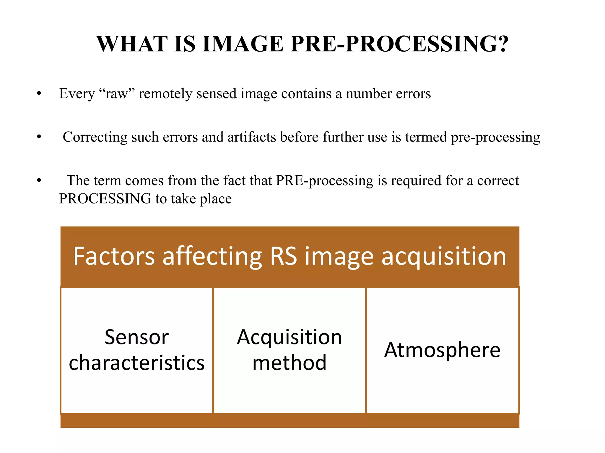
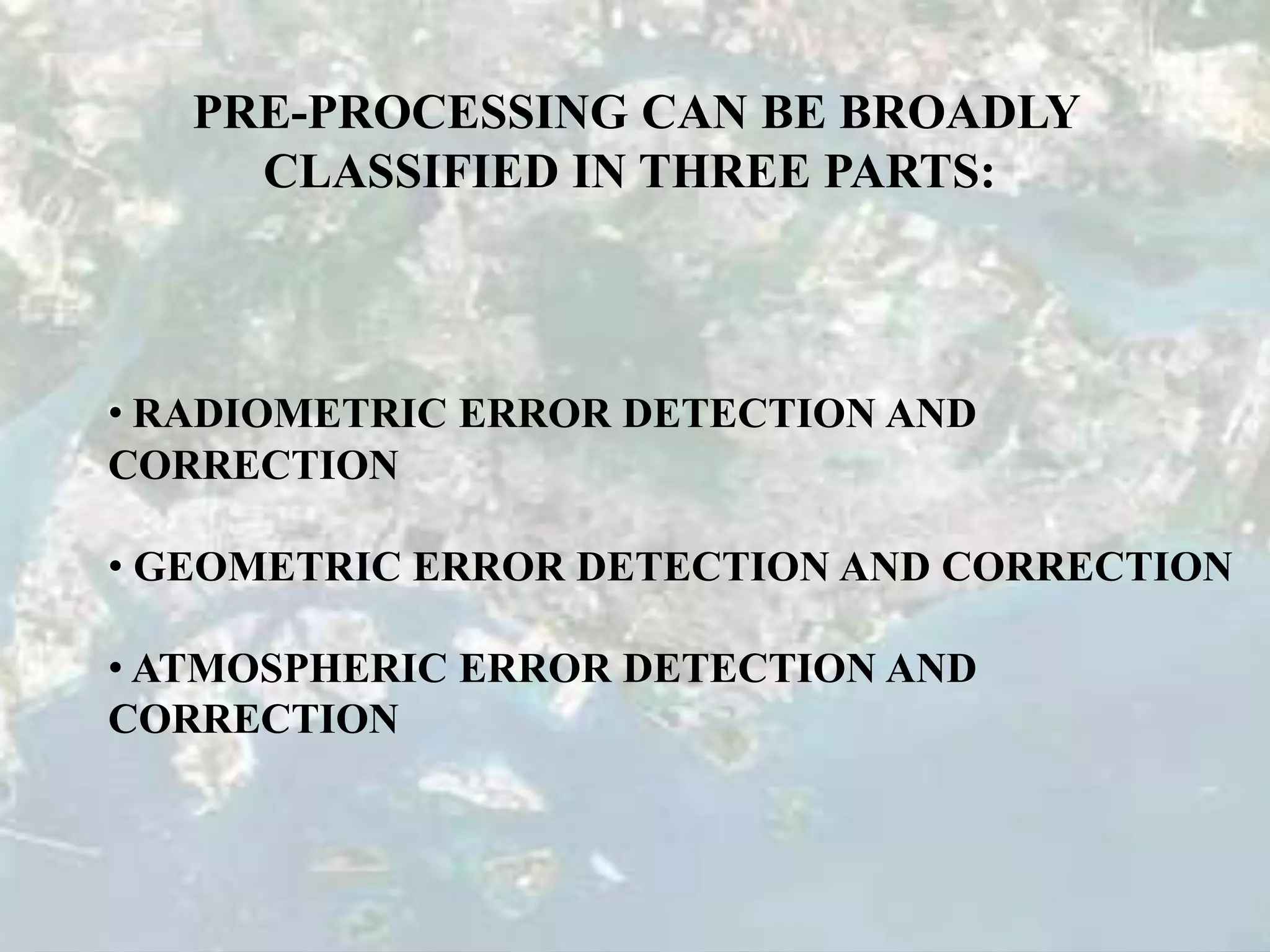
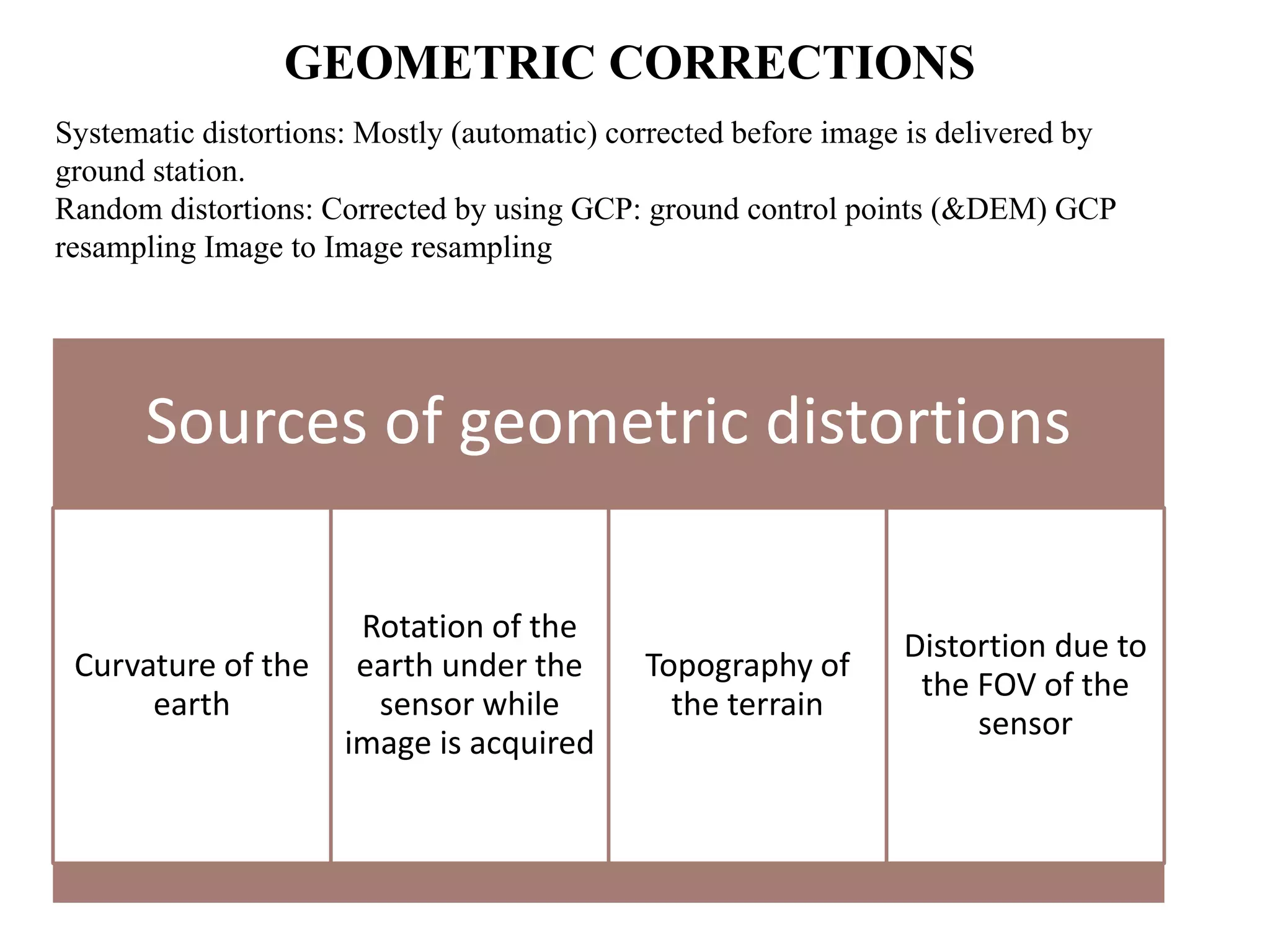
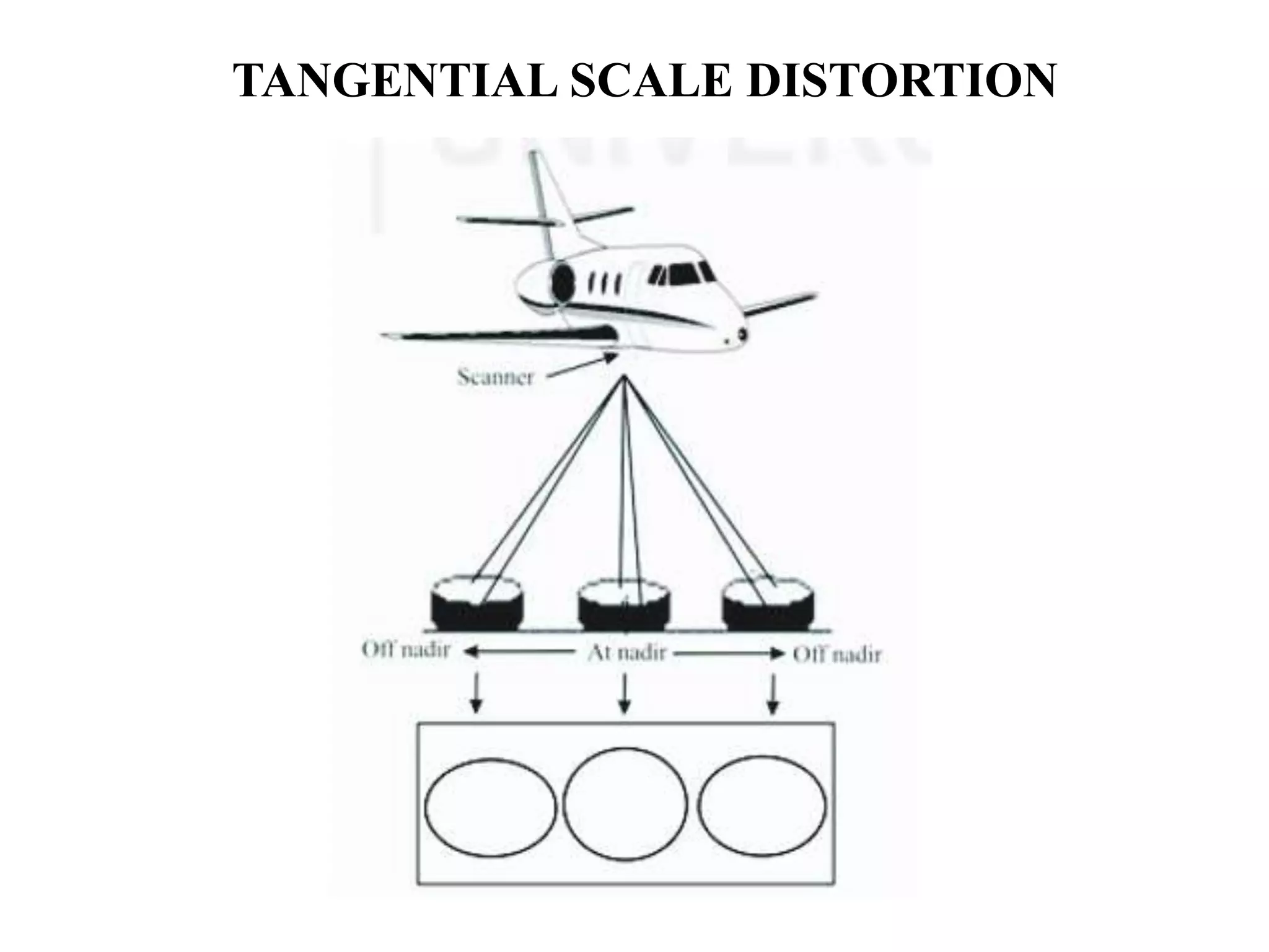
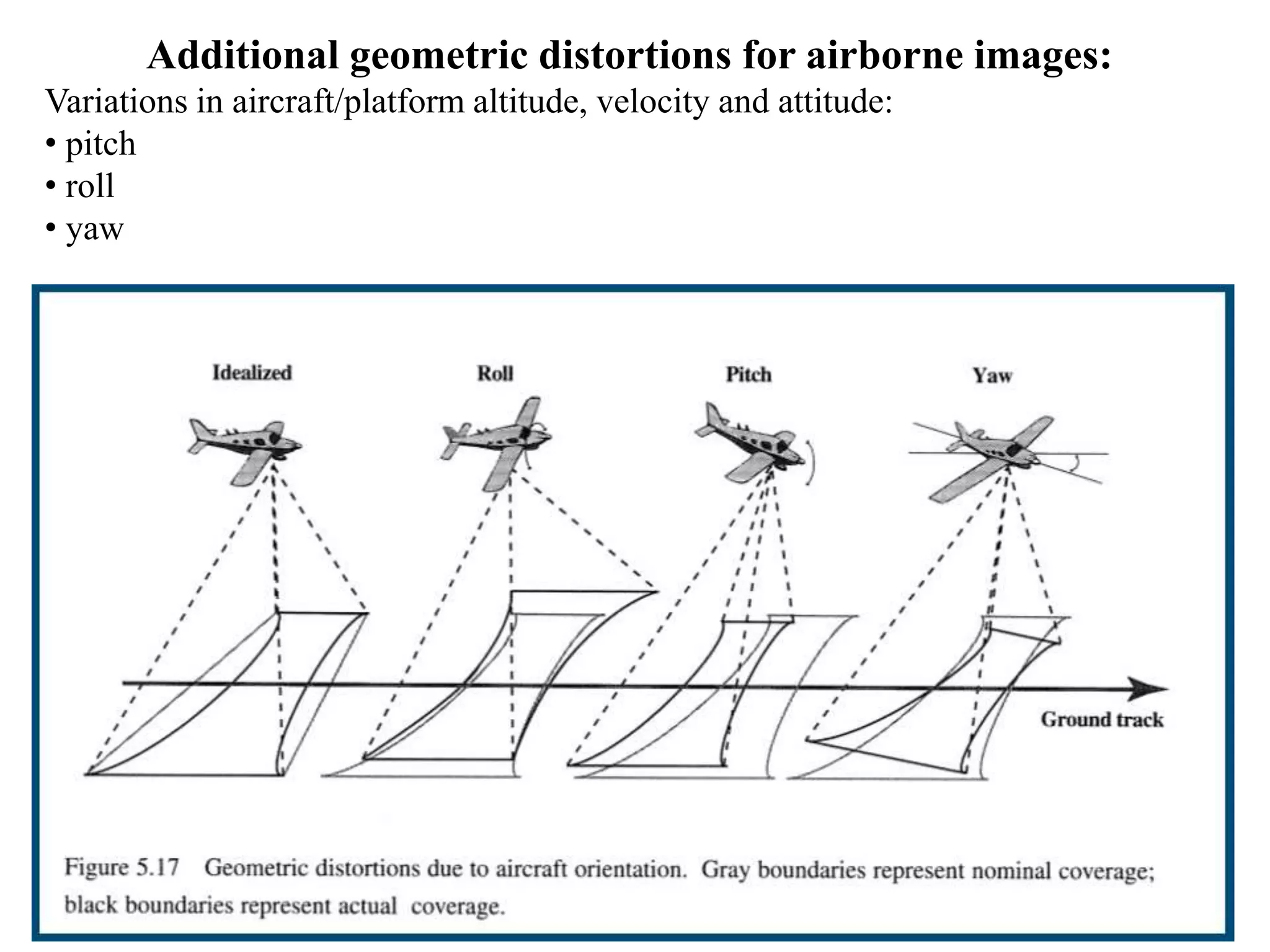
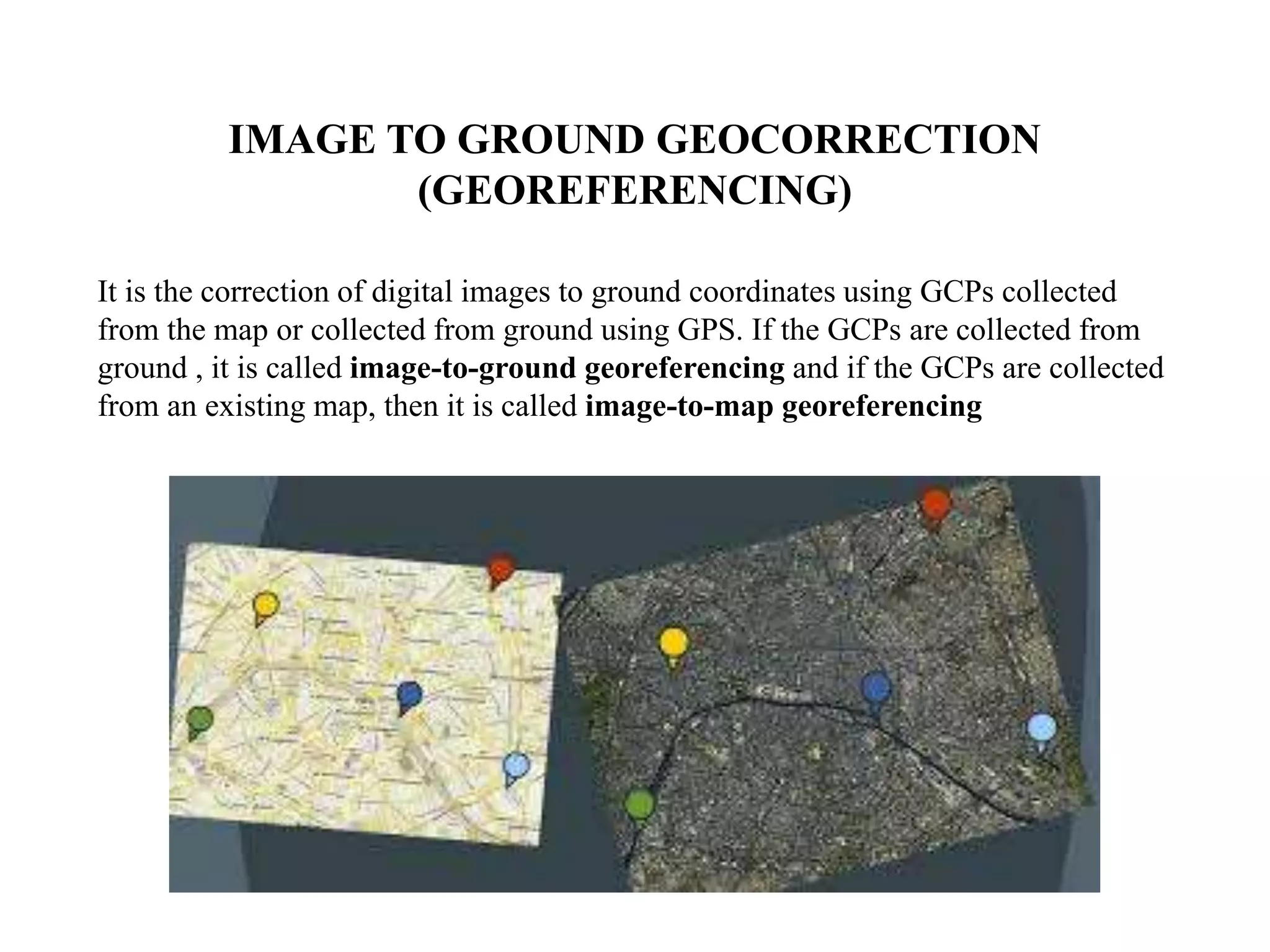
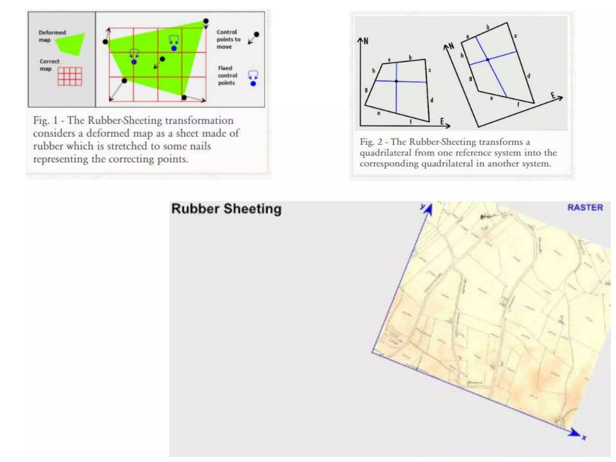
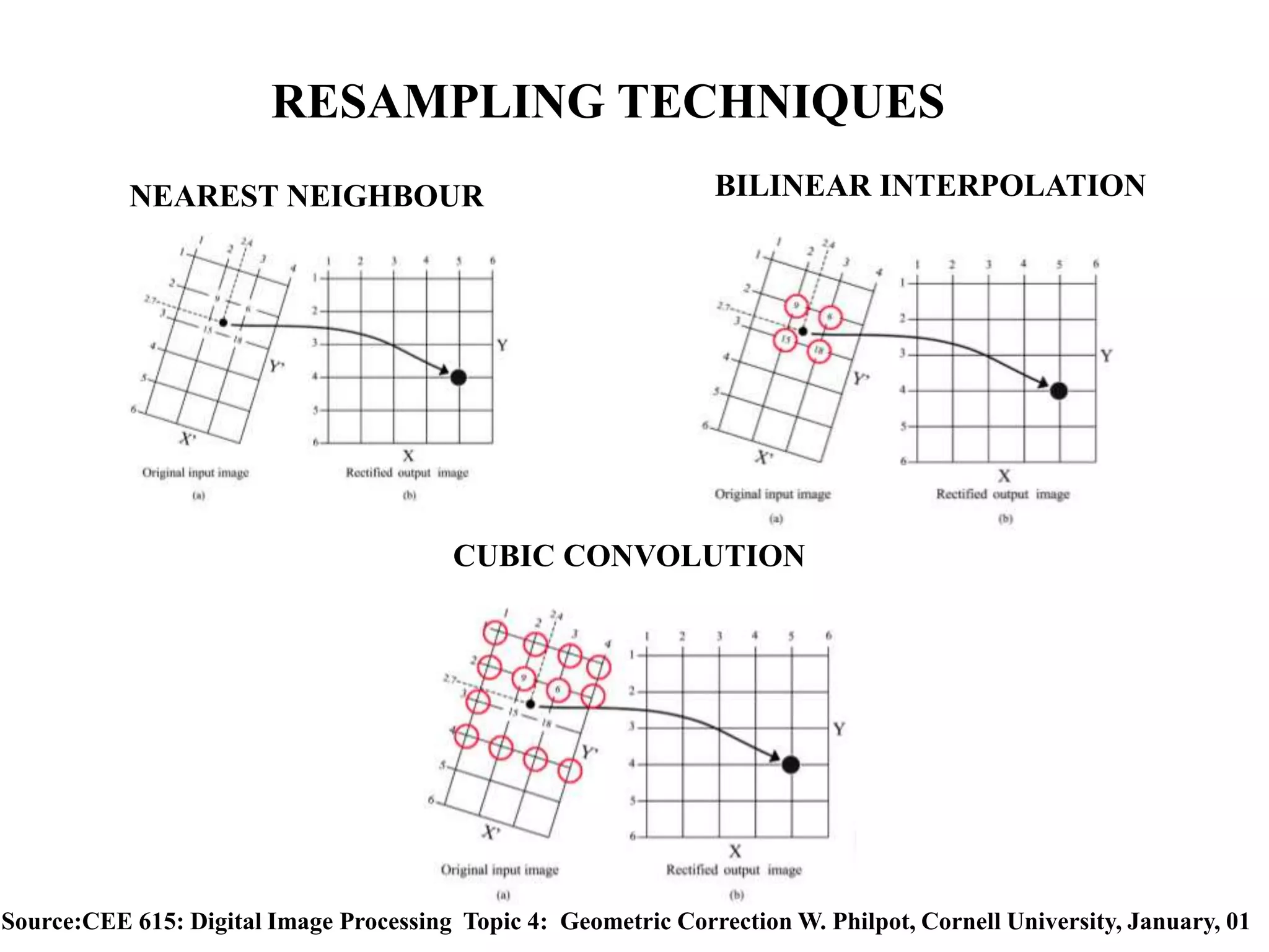
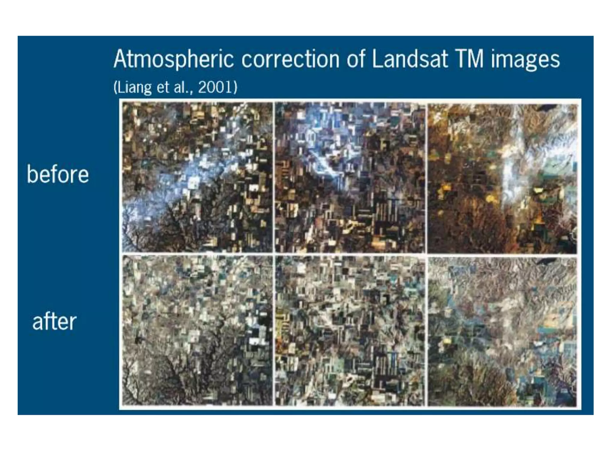
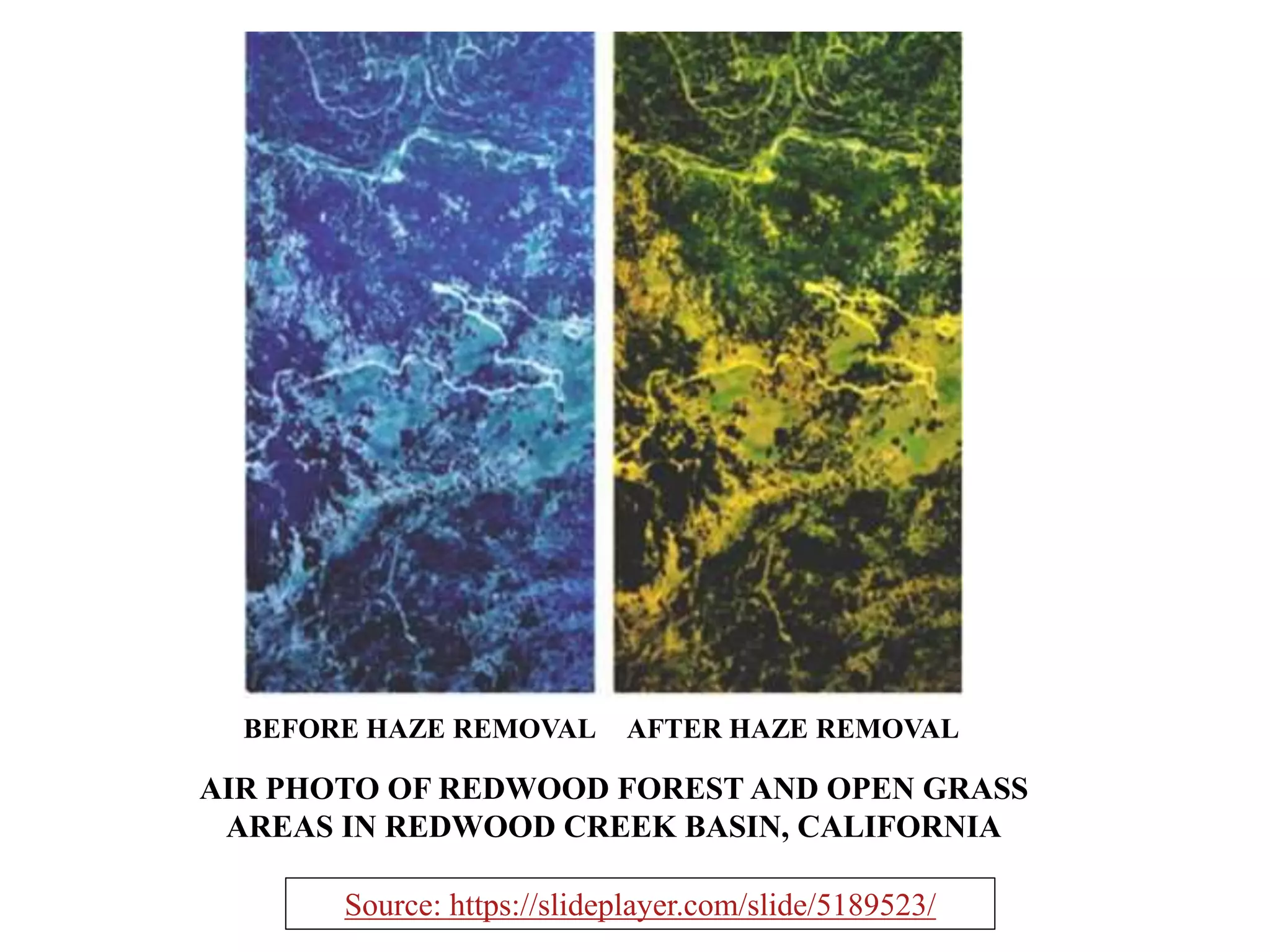
PRE-PROCESSING OF RAW
REMOTE SENSING IMAGES
PRESENTED BY
NIVRITA GHOSH
MGI/10001/19
WHAT IS IMAGE PRE-PROCESSING?
• Every “raw” remotely sensed image contains a number errors
• Correcting such errors and artifacts before further use is termed pre-processing
• The term comes from the fact that PRE-processing is required for a correct
PROCESSING to take place
Factors affecting RS image acquisition
Sensor
characteristics
Acquisition
method
Atmosphere
• Remotely sensed images of the environment are typically taken at a great
distance from the earth's surface. As a result, there is a substantial atmospheric
path that electromagnetic energy must pass through before it reaches the sensor.
Depending upon the wavelengths involved and atmospheric conditions (such as
particulate matter, moisture content and turbulence), the incoming energy may be
substantially modified.
• The sensor itself may then modify the character of that data since it may combine
a variety of mechanical, optical and electrical components that serve to modify or
mask the measured radiant energy.
• In addition, during the time the image is being scanned, the satellite is following
a path that is subject to minor variations at the same time that the earth is moving
underneath. The geometry of the image is thus in constant flux.
• Finally, the signal needs to be sent back to earth, and subsequently received and
processed to yield the final data we receive. Consequently, a variety of systematic
and apparently random disturbances can combine to degrade the quality of the
image we finally receive. Image restoration seeks to remove these degradation
effects.
WHY IS PRE-PROCESSING REQUIRED?
PRE-PROCESSING CAN BE BROADLY
CLASSIFIED IN THREE PARTS:
• RADIOMETRIC ERROR DETECTION AND
CORRECTION
• GEOMETRIC ERROR DETECTION AND CORRECTION
• ATMOSPHERIC ERROR DETECTION AND
CORRECTION
Radiometric correction refers to the removal or diminishment of distortions in the degree of
electromagnetic energy. A variety of agents can cause distortion in the values recorded for
image cells.
Some of the most common distortions for which correction procedures exist include:
• random bad pixel or short noise, due to unpredictable and unsystematic performance of
the sensor or transmission of the data;
• scan line drop out, due to signal loss from specific detectors
• N-Line striping, due to detectors going out of calibration;
RADIOMETRIC CORRECTIONS
First image is of Landsat TM band 7 data with shot noise (two black dots in the region
within the white box), second image is zoomed image of the box portion showing the bad
pixels along with DNs of the neighboring eight pixels for each bad pixel and third image
portion after the shot noise removal showing the pixel values which has replaced the bad
pixels
(source: Lecture slides of Prof. J. R. Jensen, University of South Carolina)
ILLUSTRATION OF SHORT NOISE AND
ITS REMOVAL
Data from a GER DAIS
3715 dataset of the Mixed
Waste Management
Facility on the Savannah
River Site near Aiken, SC.
The 35-band dataset was
obtained at 2 x 2 m spatial
resolution. The radiance
values along the horizontal
(X) and vertical (Y) profiles
are summarized in the next
figure. b) Enlargement of
band 10 data. c) Band 10
data after destriping. d) An
enlargement of the
destriped data
DE-STRIPPING
SCAN LINE DROP OUT
Scan line drop for LANDSAT 7
Effect of a Missing scan line;
Zero brightness value
appears black on the image
Systematic distortions: Mostly (automatic) corrected before image is delivered by
ground station.
Random distortions: Corrected by using GCP: ground control points (&DEM) GCP
resampling Image to Image resampling
GEOMETRIC CORRECTIONS
Sources of geometric distortions
Curvature of the
earth
Rotation of the
earth under the
sensor while
image is acquired
Topography of
the terrain
Distortion due to
the FOV of the
sensor
TANGENTIAL SCALE DISTORTION
Additional geometric distortions for airborne images:
Variations in aircraft/platform altitude, velocity and attitude:
• pitch
• roll
• yaw
IMAGE TO GROUND GEOCORRECTION
(GEOREFERENCING)
It is the correction of digital images to ground coordinates using GCPs collected
from the map or collected from ground using GPS. If the GCPs are collected from
ground , it is called image-to-ground georeferencing and if the GCPs are collected
from an existing map, then it is called image-to-map georeferencing
WHAT IF RUBBER-SHEETING DOES NOT
WORK?
• Photogrammetry is the science of taking spatial measurements from aerial
photographs. In order to provide a full rectification, it is necessary to have
stereoscopic images—photographs which overlap enough (e.g., 60% in the along-
track direction and 10% between flight lines) to provide two independent images of
each part of the landscape.
• Using these stereoscopic pairs and ground control points of known position and
height, it is possible to fully recreate the geometry of the viewing conditions, and
thereby not only rectify measurements from such images, but also derive
measurements of terrain height.
• The rectified photographs are called orthophotos. The height measurements may
be used to produce digital elevation models.
RESAMPLING TECHNIQUES
NEAREST NEIGHBOUR BILINEAR INTERPOLATION
CUBIC CONVOLUTION
Source:CEE 615: Digital Image Processing Topic 4: Geometric Correction W. Philpot, Cornell University, January, 01
ATMOSPHERIC CORRECTIONS
This basically happens due to absorption and scattering.
Absorption reduces the intensity with a haziness effect. Scattering redirects EM
energy in the atmosphere causing an adjacent effect where neighboring pixels are
shared.
These two processes affect the quality of an image and are the main driver for
atmospheric correction.
DOS ( Dark Object Subtraction) is perhaps the simplest yet most widely used
image-based absolute atmospheric correction approach (Chavez, 1989).
The dark object subtraction technique is the simplest and most used for image
atmospheric correction. This method assumes the existence of zero or small
surface reflectance. The minimum DN value in the histogram from an entire scene
is subtracted from all pixels.
AIR PHOTO OF REDWOOD FOREST AND OPEN GRASS
AREAS IN REDWOOD CREEK BASIN, CALIFORNIA
BEFORE HAZE REMOVAL AFTER HAZE REMOVAL
Source: https://slideplayer.com/slide/5189523/
MISCELLANEOUS PRE-PROCESSING
SUBSETTING: refers to breaking out a portion of a large area into smaller area
(Area of Interest). Also in some cases not all the bands are required for working. That
is called spectral sub setting.
REFERENCES
• https://gisgeography.com/atmospheric-correction/
• http://desktop.arcgis.com/en/arcmap/10.3/manage-data/editing-existing-
features/about-spatial-adjustment-rubbersheeting.htm
• http://www.corrmap.com/features/rubber-sheeting_transformation.php
• https://www.sciencedirect.com/science/article/abs/pii/S0034425700001693
•https://en.wikipedia.org/wiki/MODTRAN
•https://www.geospatialworld.net/article/banding-and-line-drop-errors-detection-in-
remotely-sensed-satellite-data-through-transition-count-technique/
• Remote sensing and GIS (second edition), Basudeb Bhatta
•https://www.google.com/search?q=geometrical+correction+in+remote+sensing&rlz=1C1
GGRV_enIN859IN859&oq=geometrical+correction+in+remote+sensing&aqs=chrome..69i5
7.17615j0j7&sourceid=chrome&ie=UTF-8
•https://www.google.com/search?rlz=1C1GGRV_enIN859IN859&q=missing+scan+line
s+in+remote+sensing+images&tbm=isch&source=univ&sa=X&ved=2ahUKEwi5qJC9
m-
• https://slideplayer.com/slide/5189523/
• Introduction to Digital Image Processing of Remote Sensed Data (August 22,2010)
• CEE 615: Digital Image Processing Topic 4: Geometric Correction W. Philpot, Cornell
University, January, 01
Pre processing of raw rs data

Pre processing of raw rs data

  • 1.
    PRE-PROCESSING OF RAW REMOTESENSING IMAGES PRESENTED BY NIVRITA GHOSH MGI/10001/19
  • 2.
    WHAT IS IMAGEPRE-PROCESSING? • Every “raw” remotely sensed image contains a number errors • Correcting such errors and artifacts before further use is termed pre-processing • The term comes from the fact that PRE-processing is required for a correct PROCESSING to take place Factors affecting RS image acquisition Sensor characteristics Acquisition method Atmosphere
  • 3.
    • Remotely sensedimages of the environment are typically taken at a great distance from the earth's surface. As a result, there is a substantial atmospheric path that electromagnetic energy must pass through before it reaches the sensor. Depending upon the wavelengths involved and atmospheric conditions (such as particulate matter, moisture content and turbulence), the incoming energy may be substantially modified. • The sensor itself may then modify the character of that data since it may combine a variety of mechanical, optical and electrical components that serve to modify or mask the measured radiant energy. • In addition, during the time the image is being scanned, the satellite is following a path that is subject to minor variations at the same time that the earth is moving underneath. The geometry of the image is thus in constant flux. • Finally, the signal needs to be sent back to earth, and subsequently received and processed to yield the final data we receive. Consequently, a variety of systematic and apparently random disturbances can combine to degrade the quality of the image we finally receive. Image restoration seeks to remove these degradation effects. WHY IS PRE-PROCESSING REQUIRED?
  • 4.
    PRE-PROCESSING CAN BEBROADLY CLASSIFIED IN THREE PARTS: • RADIOMETRIC ERROR DETECTION AND CORRECTION • GEOMETRIC ERROR DETECTION AND CORRECTION • ATMOSPHERIC ERROR DETECTION AND CORRECTION
  • 5.
    Radiometric correction refersto the removal or diminishment of distortions in the degree of electromagnetic energy. A variety of agents can cause distortion in the values recorded for image cells. Some of the most common distortions for which correction procedures exist include: • random bad pixel or short noise, due to unpredictable and unsystematic performance of the sensor or transmission of the data; • scan line drop out, due to signal loss from specific detectors • N-Line striping, due to detectors going out of calibration; RADIOMETRIC CORRECTIONS
  • 6.
    First image isof Landsat TM band 7 data with shot noise (two black dots in the region within the white box), second image is zoomed image of the box portion showing the bad pixels along with DNs of the neighboring eight pixels for each bad pixel and third image portion after the shot noise removal showing the pixel values which has replaced the bad pixels (source: Lecture slides of Prof. J. R. Jensen, University of South Carolina) ILLUSTRATION OF SHORT NOISE AND ITS REMOVAL
  • 7.
    Data from aGER DAIS 3715 dataset of the Mixed Waste Management Facility on the Savannah River Site near Aiken, SC. The 35-band dataset was obtained at 2 x 2 m spatial resolution. The radiance values along the horizontal (X) and vertical (Y) profiles are summarized in the next figure. b) Enlargement of band 10 data. c) Band 10 data after destriping. d) An enlargement of the destriped data DE-STRIPPING
  • 8.
    SCAN LINE DROPOUT Scan line drop for LANDSAT 7 Effect of a Missing scan line; Zero brightness value appears black on the image
  • 9.
    Systematic distortions: Mostly(automatic) corrected before image is delivered by ground station. Random distortions: Corrected by using GCP: ground control points (&DEM) GCP resampling Image to Image resampling GEOMETRIC CORRECTIONS Sources of geometric distortions Curvature of the earth Rotation of the earth under the sensor while image is acquired Topography of the terrain Distortion due to the FOV of the sensor
  • 10.
  • 11.
    Additional geometric distortionsfor airborne images: Variations in aircraft/platform altitude, velocity and attitude: • pitch • roll • yaw
  • 12.
    IMAGE TO GROUNDGEOCORRECTION (GEOREFERENCING) It is the correction of digital images to ground coordinates using GCPs collected from the map or collected from ground using GPS. If the GCPs are collected from ground , it is called image-to-ground georeferencing and if the GCPs are collected from an existing map, then it is called image-to-map georeferencing
  • 14.
    WHAT IF RUBBER-SHEETINGDOES NOT WORK? • Photogrammetry is the science of taking spatial measurements from aerial photographs. In order to provide a full rectification, it is necessary to have stereoscopic images—photographs which overlap enough (e.g., 60% in the along- track direction and 10% between flight lines) to provide two independent images of each part of the landscape. • Using these stereoscopic pairs and ground control points of known position and height, it is possible to fully recreate the geometry of the viewing conditions, and thereby not only rectify measurements from such images, but also derive measurements of terrain height. • The rectified photographs are called orthophotos. The height measurements may be used to produce digital elevation models.
  • 15.
    RESAMPLING TECHNIQUES NEAREST NEIGHBOURBILINEAR INTERPOLATION CUBIC CONVOLUTION Source:CEE 615: Digital Image Processing Topic 4: Geometric Correction W. Philpot, Cornell University, January, 01
  • 16.
    ATMOSPHERIC CORRECTIONS This basicallyhappens due to absorption and scattering. Absorption reduces the intensity with a haziness effect. Scattering redirects EM energy in the atmosphere causing an adjacent effect where neighboring pixels are shared. These two processes affect the quality of an image and are the main driver for atmospheric correction. DOS ( Dark Object Subtraction) is perhaps the simplest yet most widely used image-based absolute atmospheric correction approach (Chavez, 1989). The dark object subtraction technique is the simplest and most used for image atmospheric correction. This method assumes the existence of zero or small surface reflectance. The minimum DN value in the histogram from an entire scene is subtracted from all pixels.
  • 18.
    AIR PHOTO OFREDWOOD FOREST AND OPEN GRASS AREAS IN REDWOOD CREEK BASIN, CALIFORNIA BEFORE HAZE REMOVAL AFTER HAZE REMOVAL Source: https://slideplayer.com/slide/5189523/
  • 19.
    MISCELLANEOUS PRE-PROCESSING SUBSETTING: refersto breaking out a portion of a large area into smaller area (Area of Interest). Also in some cases not all the bands are required for working. That is called spectral sub setting.
  • 20.
    REFERENCES • https://gisgeography.com/atmospheric-correction/ • http://desktop.arcgis.com/en/arcmap/10.3/manage-data/editing-existing- features/about-spatial-adjustment-rubbersheeting.htm •http://www.corrmap.com/features/rubber-sheeting_transformation.php • https://www.sciencedirect.com/science/article/abs/pii/S0034425700001693 •https://en.wikipedia.org/wiki/MODTRAN •https://www.geospatialworld.net/article/banding-and-line-drop-errors-detection-in- remotely-sensed-satellite-data-through-transition-count-technique/ • Remote sensing and GIS (second edition), Basudeb Bhatta •https://www.google.com/search?q=geometrical+correction+in+remote+sensing&rlz=1C1 GGRV_enIN859IN859&oq=geometrical+correction+in+remote+sensing&aqs=chrome..69i5 7.17615j0j7&sourceid=chrome&ie=UTF-8 •https://www.google.com/search?rlz=1C1GGRV_enIN859IN859&q=missing+scan+line s+in+remote+sensing+images&tbm=isch&source=univ&sa=X&ved=2ahUKEwi5qJC9 m- • https://slideplayer.com/slide/5189523/ • Introduction to Digital Image Processing of Remote Sensed Data (August 22,2010) • CEE 615: Digital Image Processing Topic 4: Geometric Correction W. Philpot, Cornell University, January, 01