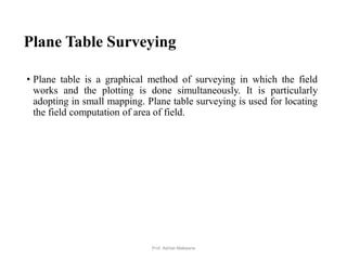
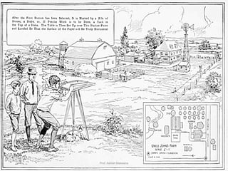
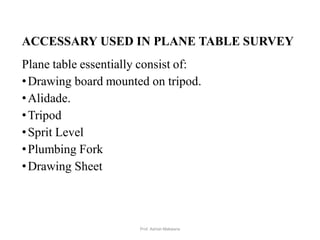
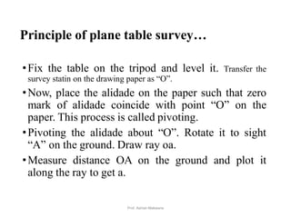
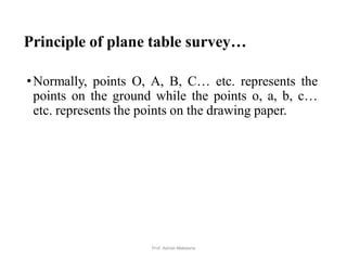
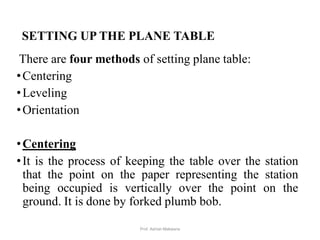
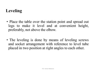
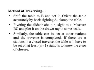
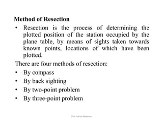
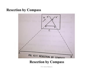
Prepared By
Prof. Ashish Makwana
Civil Engg. Dept.
Prof. Ashish Makwana 1
PRESENTATION OUTLINE…
•Plane Table Surveying
•Accessary used in Plane Table Survey
•Merits
•Demerits
•Principle of Plane Table Survey
•Setting Up the Plane Table
Prof. Ashish Makwana 2
PRESENTATION OUTLINE…
•Methods of Orientation
•Method of Radiation
•Method of Intersection
•Method of Traversing
•Method of Resection
•Points to be kept in mind in Plane Table
Prof. Ashish Makwana 3
Plane Table Surveying
• Plane table is a graphical method of surveying in which the field
works and the plotting is done simultaneously. It is particularly
adopting in small mapping. Plane table surveying is used for locating
the field computation of area of field.
4Prof. Ashish Makwana
5Prof. Ashish Makwana
ACCESSARY USED IN PLANE TABLE SURVEY
Plane table essentially consist of:
•Drawing board mounted on tripod.
•Alidade.
•Tripod
•Sprit Level
•Plumbing Fork
•Drawing Sheet
6Prof. Ashish Makwana
Drawing board mounted on tripod
•A sheet of drawing paper, called plane table sheet is
fastened to the board. Board is made up of well
seasoned wood such as teak of size 40x30 to
75x60cm.
•it had plane and smooth top. It is mounted on a
tripod in manner that it can be leveled. Leveling up
of the table is done by shifting the legs of tripod.
•Some tripod provided with leveling screw or by ball
and socket head for accurate leveling.
7Prof. Ashish Makwana
Alidade
• Alidade consists of two vertical sight vane fitted at
end the end of straightedge. The straight edge ruler
usually made of brass or teak wood graduated
beloved edge.
• One of the sight veins is provided with narrow slit
and the other with a central vertical wire or hair.
Beveled working edge alidade is called Fiducial
edge.
8Prof. Ashish Makwana
An early model Alidade
9Prof. Ashish Makwana
Measurements with the Alidade and Stadia Rod
Setup of the instrument includes:
1. Leveling the plane table
2. Drawing magnetic north reference line.
3. Measuring the instrument height.
4. Recording of scale (ensure all features to be
mapped will fit on map).
5. Recording of ground elevation directly below the
center of the plane table.
10Prof. Ashish Makwana
11Prof. Ashish Makwana
Accessories
•A through campus for marking the direction
magnetic meridian on paper.
•Sprit level for leveling the table.
•Forked plumb for centering the table.
•Water proof cover to protect the sheet from rain.
12Prof. Ashish Makwana
Merits
• It is most suitable for preparing small scale map or
surveying small area.
• It is most rapid method.
• Field book is not necessary.
• No great skill is required for satisfactory map.
• It is particularly suitable for magnetic area where
prismatic compass is not reliable.
• Contour and irregular object may be represented
accurately.
• It is less costly.
13Prof. Ashish Makwana
Demerits
•Plane Table Essentially a tropical instruments.
•It is not suitable to work in wet climate.
•There are several accessories to be carried out and
therefore they are likely to be lost.
•It is not suitable for accurate work.
14Prof. Ashish Makwana
Principle of plane table survey
•Principle: “All the rays drawn through various
details should pass through the survey station.”
•The position of plane table at each survey station
must be identical, i.e. At each survey station the
table must be oriented in the direction of magnetic
north.
15Prof. Ashish Makwana
Principle of Plane Table Survey
16Prof. Ashish Makwana
Principle of plane table survey…
•Fix the table on the tripod and level it. Transfer the
survey statin on the drawing paper as “O”.
•Now, place the alidade on the paper such that zero
mark of alidade coincide with point “O” on the
paper. This process is called pivoting.
•Pivoting the alidade about “O”. Rotate it to sight
“A” on the ground. Draw ray oa.
•Measure distance OA on the ground and plot it
along the ray to get a.
17Prof. Ashish Makwana
Principle of plane table survey…
•Normally, points O, A, B, C… etc. represents the
points on the ground while the points o, a, b, c…
etc. represents the points on the drawing paper.
18Prof. Ashish Makwana
SETTING UP THE PLANE TABLE
There are four methods of setting plane table:
•Centering
•Leveling
•Orientation
•Centering
•It is the process of keeping the table over the station
that the point on the paper representing the station
being occupied is vertically over the point on the
ground. It is done by forked plumb bob.
19Prof. Ashish Makwana
Leveling
• Place the table over the station point and spread out
legs to make it level and at convenient height,
preferably, not above the elbow.
• The leveling is done by means of leveling screws
and socket arrangement with reference to level tube
placed in two position at right angles to each other.
20Prof. Ashish Makwana
Orientation
• When the table has to be set up at more than one
station it is necessary that it is be oriented so that the
lines on the paper remain parallel to the lie which
they represent on the ground.
• So orientation is “the process of keeping the table to
the position which is occupied at the first station”.
21Prof. Ashish Makwana
Methods of Orientation
• Orientation is done by two methods are as
follows:
1. By use of the magnetic needle.
2. Orientation by back sighting.
22Prof. Ashish Makwana
Orientation by the magnetic needle
•To orient the table at any subsequent station, the
through compass(or circular box compass) is placed
along the line representing the magnetic meridian
which has been drawn on the paper at the first
station, and the board is then turned until the ends of
the needle oare opposite the zeros of the scale.
•The board is then clamped in position. It is suitable
for rough small scale mapping.
23Prof. Ashish Makwana
Orientation by back sighting
• This is the most accurate method of orientation and
is always be preferred. Suppose a table is set up
over station Q on the line PQ which has been
previously drowned as PQ from station p.
• The alidade is placed along the line QP and board
then turned until the line of sight bisects the ranging
rod at P. Board is then properly clamped.
24Prof. Ashish Makwana
THREE POINT PROBLEM BY BESSEL METHOD
• Let P be the plane-table station and A, B, C be the
three well defined ground points, which are
represented as a, b, c, respectively on the plan When
resectors drawn through a, b, and c meet at a point p,
then the table is said to be correctly oriented at P,
giving the location of the plane-table station.
• This may be obtained using Bessel’s graphical
solution available in a number of sources.
25Prof. Ashish Makwana
 The procedure is summarized as follows:
• Set the plane table at station P. Keep the edge of the alidade on the
ba line and rotate the table until A is bisected. Clamp the table;
• Pivot the alidade about b and sight to C. Draw the ray xy along the
edge of the alidade Fig. 1(a).
• Keep the alidade along the ab line and rotate the table until B is
bisected. Clamp the table.
• Pivot the alidade about a and sight to C. Draw the ray along the edge
of the alidade to intersect the ray xy in c Fig. 1(b). Join cc.
26Prof. Ashish Makwana
• Keep the alidade along the cc line and rotate the table until C is
bisected. Clamp the table. The table is correctly oriented Fig. 1(c) and
• Pivot the alidade about b, sight to B. Draw the ray to intersect cc in p.
Similarly, if the alidade is pivoted about a and A is sighted, the ray will
pass through p if the work is accurate.
27Prof. Ashish Makwana
28Prof. Ashish Makwana
Advantages
•It is one of the most rapid methods of surveying.
•Checking of plotted details can be done easily.
•Office works is practically reduced to nil.
•Less costly as compared to other methods of
surveying.
•Since notes of measurements are not recorded, it is
great inconvenient to reproduce the map to another
scale.
29Prof. Ashish Makwana
Disadvantages
• It is not very accurate.
• It is inconvenient in rainy reason or in wet climate.
• It requires many accessories on the field.
• Due to heaviness, it is inconvenient to transport.
30Prof. Ashish Makwana
METHOD OF PLANE TABLING
There are four distinct methods of plane tabling:
• Method of Radiation
• Method of Intersection
• Method of Traversing
• Method of Resection
31Prof. Ashish Makwana
Method of Radiation
32
Method of Radiation
Prof. Ashish Makwana
Method of Radiation:
• This is the simplest method and it is useful only
when the whole traverse can be commanded
from a single station.
• Set the table at ‘O’ and level it. Transfer point O,
on to the sheet by means of plumbing fork.
• Keep the alidade touching O and sight to A.
Draw the ray along the fiducial edge of the
alidade. Measure distance OA, on ground and put
this length to a suitable scale on paper which will
give point a on the paper.
33Prof. Ashish Makwana
• Similarly, obtain points b, c, d and e on paper by
drawing lines of sight for stations B, C, D and E
and measuring the distances OB, OC, OD and
OE on ground respectively.
• Join a, b, c, d and e on paper.
• For checking the accuracy of work, measure the
distances AB, BC, CD, DE and EA and compare
them with the lengths ab, bc, cd, de and ca
respectively on paper.
34Prof. Ashish Makwana
Method of Intersection
35
Method of Intersection
Prof. Ashish Makwana
• Method of Intersection:
• This method is useful where it is not possible to
measure the distances on ground.
• The location of an object is determined by
sighting at the object from two plane table
stations and drawing the rays. The intersection of
these rays will give the position of the object.
36Prof. Ashish Makwana
• Set the plane table at A, level it and transfer the
point A on to the sheet by way of plumbing fork.
Clamp the table.
• With the help of trough compass, mark the north
direction on the sheet.
• Pivoting the alidade about a, sight it to B.
Measure AB and plot it along the ray to get b.
The base line ab is thus drawn.
• Pivoting the alidade about a, sight the details C,
D etc. and draw corresponding rays.
37Prof. Ashish Makwana
• Shift the table at B and set it there orient the table
by back sighting A.
• Pivot the alidade about b, sight the details C, D
etc. and draw the corresponding rays to intersect
the previously drawn rays at c, d etc.
• Thus, the plot ABCD can be plotted on paper as
abcd.
38Prof. Ashish Makwana
Method of Traversing
39
Method of Traversing
Prof. Ashish Makwana
• Method of Traversing
• This method resembles the work of a compass
survey and it is useful for the survey work of
roads, rivers etc.
• Set the plane table at A. Use plumbing fork for
transferring A on to the sheet. Draw the direction
of magnetic meridian with the help of trough
compass.
• With the alidade pivoted about a, sight it to B and
draw the ray. Measure AB and scale of ab to
some scale. Similarly, draw a ray towards E,
measure AE and plot e.
40Prof. Ashish Makwana
Method of Traversing…
• Shift the table to B and set it. Orient the table
accurately by back sighting A. clamp the table.
• Pivoting the alidade about b, sight to c. Measure
BC and plot it on the drawn ray to some scale.
• Similarly, the table can be set at other stations
and the traverse is completed. If there are n
stations in a closed traverse, the table will have to
be set on at least (n - 1) stations to know the error
of closure.
41Prof. Ashish Makwana
Method of Resection
• Resection is the process of determining the
plotted position of the station occupied by the
plane table, by means of sights taken towards
known points, locations of which have been
plotted.
There are four methods of resection:
• By compass
• By back sighting
• By two-point problem
• By three-point problem
42Prof. Ashish Makwana
Resection by Compass
43
Resection by Compass
Prof. Ashish Makwana
• By compass
• This method is used only for small scale or rough
mapping.
• Let A and B be two visible stations which have
been plotted on the sheet as a and b. Let C be the
instrument station to be located on the plan.
• Set the table at C and orient it with compass.
Clamp the table.
• Pivoting the alidade about a, draw a ray
(resector) towards A, aa’. Similarly, pivoting the
alidade about b, draw a ray towards B, as bb’.
The intersection of aa’ and bb’ will give point c
on the paper.
44Prof. Ashish Makwana
• Points to be kept in mind in Plane Table
• The following points should be kept in mind while
doing plane table survey.
1. Ground points shall be marked as A, B, C … etc.
and plan points (on paper) shall be marked as a, b,
c…etc.
2. The rays from survey stations to the objects shall be
drawn by dashed line.
3. The alidade should be properly pivoted while
sighting the objects.
4. The first survey station and the scale of the map
shall be so chosen that the entire area can be plotted on
the paper.
45Prof. Ashish Makwana
Points to be kept in mind in Plane Table…
5. While establishing magnetic north on the paper
using trough compass, things causing local attraction
shall be kept away of the table.
6. The plane table should be clamped after centering
and levelling. The table should be rotated only at the
time of orientation.
46Prof. Ashish Makwana
• Errors in Plane Tabling
The various sources of errors are classified as:
1. Instrumental errors
2. Errors in manipulation and sighting
3. Errors in plotting
1. Instrumental errors
 The surface of drawing boards is not plane.
 The edge of alidade is not straight.
 The object vane and sight vane are not
perpendicular to the alidade.
 The edge of alidade is not parallel to the line of
sight.
 The fixing clamp is not proper.
47Prof. Ashish Makwana
2. Errors in manipulation and sighting
 Defective levelling
 Defective sighting
 Defective orientation
 Defective centering
 Movement of board between sights
3. Errors in plotting
 Defective scale of map
 Wrongly intersecting the rays drawn from two
different stations
48Prof. Ashish Makwana
THANK YOU
49Prof. Ashish Makwana

Plane table survey_Surveying, Civil Engineering

  • 1.
    Prepared By Prof. AshishMakwana Civil Engg. Dept. Prof. Ashish Makwana 1
  • 2.
    PRESENTATION OUTLINE… •Plane TableSurveying •Accessary used in Plane Table Survey •Merits •Demerits •Principle of Plane Table Survey •Setting Up the Plane Table Prof. Ashish Makwana 2
  • 3.
    PRESENTATION OUTLINE… •Methods ofOrientation •Method of Radiation •Method of Intersection •Method of Traversing •Method of Resection •Points to be kept in mind in Plane Table Prof. Ashish Makwana 3
  • 4.
    Plane Table Surveying •Plane table is a graphical method of surveying in which the field works and the plotting is done simultaneously. It is particularly adopting in small mapping. Plane table surveying is used for locating the field computation of area of field. 4Prof. Ashish Makwana
  • 5.
  • 6.
    ACCESSARY USED INPLANE TABLE SURVEY Plane table essentially consist of: •Drawing board mounted on tripod. •Alidade. •Tripod •Sprit Level •Plumbing Fork •Drawing Sheet 6Prof. Ashish Makwana
  • 7.
    Drawing board mountedon tripod •A sheet of drawing paper, called plane table sheet is fastened to the board. Board is made up of well seasoned wood such as teak of size 40x30 to 75x60cm. •it had plane and smooth top. It is mounted on a tripod in manner that it can be leveled. Leveling up of the table is done by shifting the legs of tripod. •Some tripod provided with leveling screw or by ball and socket head for accurate leveling. 7Prof. Ashish Makwana
  • 8.
    Alidade • Alidade consistsof two vertical sight vane fitted at end the end of straightedge. The straight edge ruler usually made of brass or teak wood graduated beloved edge. • One of the sight veins is provided with narrow slit and the other with a central vertical wire or hair. Beveled working edge alidade is called Fiducial edge. 8Prof. Ashish Makwana
  • 9.
    An early modelAlidade 9Prof. Ashish Makwana
  • 10.
    Measurements with theAlidade and Stadia Rod Setup of the instrument includes: 1. Leveling the plane table 2. Drawing magnetic north reference line. 3. Measuring the instrument height. 4. Recording of scale (ensure all features to be mapped will fit on map). 5. Recording of ground elevation directly below the center of the plane table. 10Prof. Ashish Makwana
  • 11.
  • 12.
    Accessories •A through campusfor marking the direction magnetic meridian on paper. •Sprit level for leveling the table. •Forked plumb for centering the table. •Water proof cover to protect the sheet from rain. 12Prof. Ashish Makwana
  • 13.
    Merits • It ismost suitable for preparing small scale map or surveying small area. • It is most rapid method. • Field book is not necessary. • No great skill is required for satisfactory map. • It is particularly suitable for magnetic area where prismatic compass is not reliable. • Contour and irregular object may be represented accurately. • It is less costly. 13Prof. Ashish Makwana
  • 14.
    Demerits •Plane Table Essentiallya tropical instruments. •It is not suitable to work in wet climate. •There are several accessories to be carried out and therefore they are likely to be lost. •It is not suitable for accurate work. 14Prof. Ashish Makwana
  • 15.
    Principle of planetable survey •Principle: “All the rays drawn through various details should pass through the survey station.” •The position of plane table at each survey station must be identical, i.e. At each survey station the table must be oriented in the direction of magnetic north. 15Prof. Ashish Makwana
  • 16.
    Principle of PlaneTable Survey 16Prof. Ashish Makwana
  • 17.
    Principle of planetable survey… •Fix the table on the tripod and level it. Transfer the survey statin on the drawing paper as “O”. •Now, place the alidade on the paper such that zero mark of alidade coincide with point “O” on the paper. This process is called pivoting. •Pivoting the alidade about “O”. Rotate it to sight “A” on the ground. Draw ray oa. •Measure distance OA on the ground and plot it along the ray to get a. 17Prof. Ashish Makwana
  • 18.
    Principle of planetable survey… •Normally, points O, A, B, C… etc. represents the points on the ground while the points o, a, b, c… etc. represents the points on the drawing paper. 18Prof. Ashish Makwana
  • 19.
    SETTING UP THEPLANE TABLE There are four methods of setting plane table: •Centering •Leveling •Orientation •Centering •It is the process of keeping the table over the station that the point on the paper representing the station being occupied is vertically over the point on the ground. It is done by forked plumb bob. 19Prof. Ashish Makwana
  • 20.
    Leveling • Place thetable over the station point and spread out legs to make it level and at convenient height, preferably, not above the elbow. • The leveling is done by means of leveling screws and socket arrangement with reference to level tube placed in two position at right angles to each other. 20Prof. Ashish Makwana
  • 21.
    Orientation • When thetable has to be set up at more than one station it is necessary that it is be oriented so that the lines on the paper remain parallel to the lie which they represent on the ground. • So orientation is “the process of keeping the table to the position which is occupied at the first station”. 21Prof. Ashish Makwana
  • 22.
    Methods of Orientation •Orientation is done by two methods are as follows: 1. By use of the magnetic needle. 2. Orientation by back sighting. 22Prof. Ashish Makwana
  • 23.
    Orientation by themagnetic needle •To orient the table at any subsequent station, the through compass(or circular box compass) is placed along the line representing the magnetic meridian which has been drawn on the paper at the first station, and the board is then turned until the ends of the needle oare opposite the zeros of the scale. •The board is then clamped in position. It is suitable for rough small scale mapping. 23Prof. Ashish Makwana
  • 24.
    Orientation by backsighting • This is the most accurate method of orientation and is always be preferred. Suppose a table is set up over station Q on the line PQ which has been previously drowned as PQ from station p. • The alidade is placed along the line QP and board then turned until the line of sight bisects the ranging rod at P. Board is then properly clamped. 24Prof. Ashish Makwana
  • 25.
    THREE POINT PROBLEMBY BESSEL METHOD • Let P be the plane-table station and A, B, C be the three well defined ground points, which are represented as a, b, c, respectively on the plan When resectors drawn through a, b, and c meet at a point p, then the table is said to be correctly oriented at P, giving the location of the plane-table station. • This may be obtained using Bessel’s graphical solution available in a number of sources. 25Prof. Ashish Makwana
  • 26.
     The procedureis summarized as follows: • Set the plane table at station P. Keep the edge of the alidade on the ba line and rotate the table until A is bisected. Clamp the table; • Pivot the alidade about b and sight to C. Draw the ray xy along the edge of the alidade Fig. 1(a). • Keep the alidade along the ab line and rotate the table until B is bisected. Clamp the table. • Pivot the alidade about a and sight to C. Draw the ray along the edge of the alidade to intersect the ray xy in c Fig. 1(b). Join cc. 26Prof. Ashish Makwana
  • 27.
    • Keep thealidade along the cc line and rotate the table until C is bisected. Clamp the table. The table is correctly oriented Fig. 1(c) and • Pivot the alidade about b, sight to B. Draw the ray to intersect cc in p. Similarly, if the alidade is pivoted about a and A is sighted, the ray will pass through p if the work is accurate. 27Prof. Ashish Makwana
  • 28.
  • 29.
    Advantages •It is oneof the most rapid methods of surveying. •Checking of plotted details can be done easily. •Office works is practically reduced to nil. •Less costly as compared to other methods of surveying. •Since notes of measurements are not recorded, it is great inconvenient to reproduce the map to another scale. 29Prof. Ashish Makwana
  • 30.
    Disadvantages • It isnot very accurate. • It is inconvenient in rainy reason or in wet climate. • It requires many accessories on the field. • Due to heaviness, it is inconvenient to transport. 30Prof. Ashish Makwana
  • 31.
    METHOD OF PLANETABLING There are four distinct methods of plane tabling: • Method of Radiation • Method of Intersection • Method of Traversing • Method of Resection 31Prof. Ashish Makwana
  • 32.
    Method of Radiation 32 Methodof Radiation Prof. Ashish Makwana
  • 33.
    Method of Radiation: •This is the simplest method and it is useful only when the whole traverse can be commanded from a single station. • Set the table at ‘O’ and level it. Transfer point O, on to the sheet by means of plumbing fork. • Keep the alidade touching O and sight to A. Draw the ray along the fiducial edge of the alidade. Measure distance OA, on ground and put this length to a suitable scale on paper which will give point a on the paper. 33Prof. Ashish Makwana
  • 34.
    • Similarly, obtainpoints b, c, d and e on paper by drawing lines of sight for stations B, C, D and E and measuring the distances OB, OC, OD and OE on ground respectively. • Join a, b, c, d and e on paper. • For checking the accuracy of work, measure the distances AB, BC, CD, DE and EA and compare them with the lengths ab, bc, cd, de and ca respectively on paper. 34Prof. Ashish Makwana
  • 35.
    Method of Intersection 35 Methodof Intersection Prof. Ashish Makwana
  • 36.
    • Method ofIntersection: • This method is useful where it is not possible to measure the distances on ground. • The location of an object is determined by sighting at the object from two plane table stations and drawing the rays. The intersection of these rays will give the position of the object. 36Prof. Ashish Makwana
  • 37.
    • Set theplane table at A, level it and transfer the point A on to the sheet by way of plumbing fork. Clamp the table. • With the help of trough compass, mark the north direction on the sheet. • Pivoting the alidade about a, sight it to B. Measure AB and plot it along the ray to get b. The base line ab is thus drawn. • Pivoting the alidade about a, sight the details C, D etc. and draw corresponding rays. 37Prof. Ashish Makwana
  • 38.
    • Shift thetable at B and set it there orient the table by back sighting A. • Pivot the alidade about b, sight the details C, D etc. and draw the corresponding rays to intersect the previously drawn rays at c, d etc. • Thus, the plot ABCD can be plotted on paper as abcd. 38Prof. Ashish Makwana
  • 39.
    Method of Traversing 39 Methodof Traversing Prof. Ashish Makwana
  • 40.
    • Method ofTraversing • This method resembles the work of a compass survey and it is useful for the survey work of roads, rivers etc. • Set the plane table at A. Use plumbing fork for transferring A on to the sheet. Draw the direction of magnetic meridian with the help of trough compass. • With the alidade pivoted about a, sight it to B and draw the ray. Measure AB and scale of ab to some scale. Similarly, draw a ray towards E, measure AE and plot e. 40Prof. Ashish Makwana
  • 41.
    Method of Traversing… •Shift the table to B and set it. Orient the table accurately by back sighting A. clamp the table. • Pivoting the alidade about b, sight to c. Measure BC and plot it on the drawn ray to some scale. • Similarly, the table can be set at other stations and the traverse is completed. If there are n stations in a closed traverse, the table will have to be set on at least (n - 1) stations to know the error of closure. 41Prof. Ashish Makwana
  • 42.
    Method of Resection •Resection is the process of determining the plotted position of the station occupied by the plane table, by means of sights taken towards known points, locations of which have been plotted. There are four methods of resection: • By compass • By back sighting • By two-point problem • By three-point problem 42Prof. Ashish Makwana
  • 43.
    Resection by Compass 43 Resectionby Compass Prof. Ashish Makwana
  • 44.
    • By compass •This method is used only for small scale or rough mapping. • Let A and B be two visible stations which have been plotted on the sheet as a and b. Let C be the instrument station to be located on the plan. • Set the table at C and orient it with compass. Clamp the table. • Pivoting the alidade about a, draw a ray (resector) towards A, aa’. Similarly, pivoting the alidade about b, draw a ray towards B, as bb’. The intersection of aa’ and bb’ will give point c on the paper. 44Prof. Ashish Makwana
  • 45.
    • Points tobe kept in mind in Plane Table • The following points should be kept in mind while doing plane table survey. 1. Ground points shall be marked as A, B, C … etc. and plan points (on paper) shall be marked as a, b, c…etc. 2. The rays from survey stations to the objects shall be drawn by dashed line. 3. The alidade should be properly pivoted while sighting the objects. 4. The first survey station and the scale of the map shall be so chosen that the entire area can be plotted on the paper. 45Prof. Ashish Makwana
  • 46.
    Points to bekept in mind in Plane Table… 5. While establishing magnetic north on the paper using trough compass, things causing local attraction shall be kept away of the table. 6. The plane table should be clamped after centering and levelling. The table should be rotated only at the time of orientation. 46Prof. Ashish Makwana
  • 47.
    • Errors inPlane Tabling The various sources of errors are classified as: 1. Instrumental errors 2. Errors in manipulation and sighting 3. Errors in plotting 1. Instrumental errors  The surface of drawing boards is not plane.  The edge of alidade is not straight.  The object vane and sight vane are not perpendicular to the alidade.  The edge of alidade is not parallel to the line of sight.  The fixing clamp is not proper. 47Prof. Ashish Makwana
  • 48.
    2. Errors inmanipulation and sighting  Defective levelling  Defective sighting  Defective orientation  Defective centering  Movement of board between sights 3. Errors in plotting  Defective scale of map  Wrongly intersecting the rays drawn from two different stations 48Prof. Ashish Makwana
  • 49.