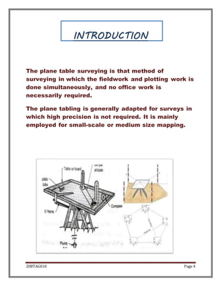
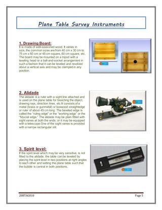
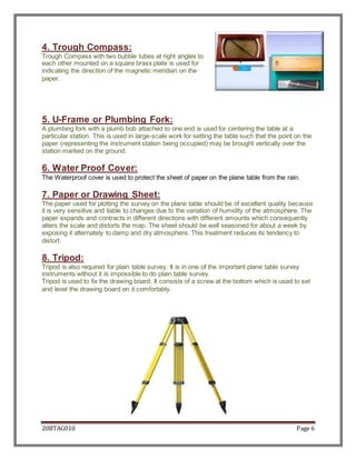
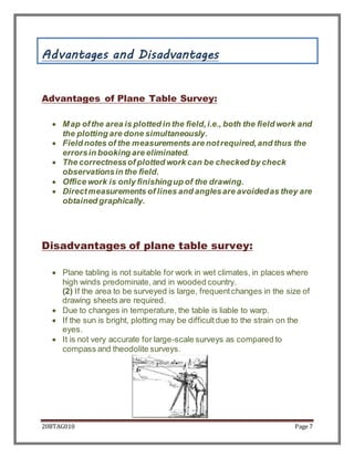
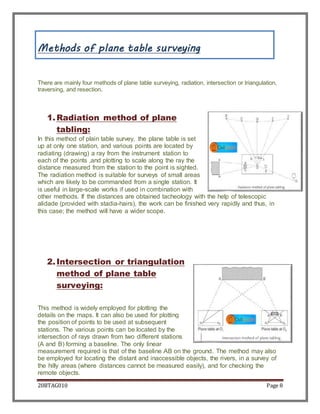
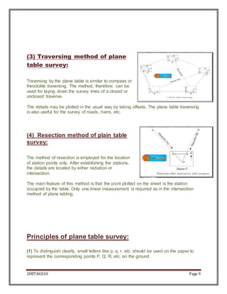
This document discusses plane table surveying. It begins with an acknowledgement and introduction. It then describes the common instruments used in plane table surveying like the drawing board, alidade, spirit level, trough compass, U-frame, paper, and tripod. The next sections cover the advantages and disadvantages of the plane table method, and the main methods used: radiation, intersection, traversing, and resection. Principles of plane table surveying are also outlined. Bibliographic references are provided at the end.
2. 20BTAG010 Page 2
Table of content
01
02
03
04
05
INTRODUCTION
INSTRUMENTS
ADVANTAGES &
DISADVANTAGES
METHODS OF
PLANE SURVEY
PRINCIPLE OF
PLANE SURVEY
3. 20BTAG010 Page 3
ACKNOWLEDGEMENT
It is a matter of pleasure of acknowledgement by
indebtedness to my Survey and leveling professor
“name” for his great and needy half in the
completion of this project. I excess my thanks and
gratitude to them. They helped me and provided with
his valuable guidance at each and every step.
Name
4. 20BTAG010 Page 4
INTRODUCTION
The plane table surveying is that method of
surveying in which the fieldwork and plotting work is
done simultaneously, and no office work is
necessarily required.
The plane tabling is generally adapted for surveys in
which high precision is not required. It is mainly
employed for small-scale or medium size mapping.
5. 20BTAG010 Page 5
Plane Table Survey Instruments
1. Drawing Board:
It is made of well-seasoned wood. It varies in
size, the common sizes are from 40 cm x 30 cm to
75 cm x 60 cm or 45 cm square, 60 cm square, etc.
The board may be mounted on a tripod with a
leveling head or a ball-and-socket arrangement in
such a fashion that it can be leveled and revolved
about a vertical axis and may be clamped in any
position.
2. Alidade
The alidade is a ruler with a sight line attached and
is used on the plane table for bisecting the object,
drawing rays, direction lines, etc.It consists of a
metal (brass or gunmetal) or boxwood straightedge
or ruler of about 45 cm long. The beveled edge is
called the “ruling edge” or the “working edge” or the
“fiducial edge.” The alidade may be plain fitted with
sight vanes at both the ends, or it may be equipped
with a telescope.One of the sight vanes is provided
with a narrow rectangular slit.
3. Spirit level:
If the spirit level which may be very sensitive, is not
fitted to the alidade, the table can be leveled by
placing the spirit level in two positions at right angles
to each other and setting the plane table such that
the bubble is central in both positions.
6. 20BTAG010 Page 6
4. Trough Compass:
Trough Compass with two bubble tubes at right angles to
each other mounted on a square brass plate is used for
indicating the direction of the magnetic meridian on the
paper.
5. U-Frame or Plumbing Fork:
A plumbing fork with a plumb bob attached to one end is used for centering the table at a
particular station. This is used in large-scale work for setting the table such that the point on the
paper (representing the instrument station being occupied) may be brought vertically over the
station marked on the ground.
6. Water Proof Cover:
The Waterproof cover is used to protect the sheet of paper on the plane table from the rain.
7. Paper or Drawing Sheet:
The paper used for plotting the survey on the plane table should be of excellent quality because
it is very sensitive and liable to changes due to the variation of humidity of the atmosphere. The
paper expands and contracts in different directions with different amounts which consequently
alters the scale and distorts the map. The sheet should be well seasoned for about a week by
exposing it alternately to damp and dry atmosphere. This treatment reduces its tendency to
distort.
8. Tripod:
Tripod is also required for plain table survey. It is in one of the important plane table survey
instruments without it is impossible to do plain table survey.
Tripod is used to fix the drawing board. It consists of a screw at the bottom which is used to set
and level the drawing board on it comfortably.
7. 20BTAG010 Page 7
Advantages and Disadvantages
Advantages of Plane Table Survey:
Map ofthe area is plotted in the field,i.e., both the field work and
the plotting are done simultaneously.
Field notes of the measurements are notrequired,and thus the
errorsin booking are eliminated.
The correctnessof plotted work can be checked by check
observationsin the field.
Office work is only finishingup of the drawing.
Directmeasurements of lines and anglesare avoidedas they are
obtained graphically.
Disadvantages of plane table survey:
Plane tabling is not suitable for work in wet climates, in places where
high winds predominate, and in wooded country.
(2) If the area to be surveyed is large, frequentchanges in the size of
drawing sheets are required.
Due to changes in temperature, the table is liable to warp.
If the sun is bright, plotting may be difficultdue to the strain on the
eyes.
It is not very accurate for large-scale surveys as compared to
compass and theodolite surveys.
8. 20BTAG010 Page 8
Methods of plane table surveying
There are mainly four methods of plane table surveying, radiation, intersection or triangulation,
traversing, and resection.
1.Radiation method of plane
tabling:
In this method of plain table survey, the plane table is set
up at only one station, and various points are located by
radiating (drawing) a ray from the instrument station to
each of the points ,and plotting to scale along the ray the
distance measured from the station to the point is sighted.
The radiation method is suitable for surveys of small areas
which are likely to be commanded from a single station. It
is useful in large-scale works if used in combination with
other methods. If the distances are obtained tacheology with the help of telescopic
alidade (provided with stadia-hairs), the work can be finished very rapidly and thus, in
this case; the method will have a wider scope.
2.Intersection or triangulation
method of plane table
surveying:
This method is widely employed for plotting the
details on the maps. It can also be used for plotting
the position of points to be used at subsequent
stations. The various points can be located by the
intersection of rays drawn from two different stations
(A and B) forming a baseline. The only linear
measurement required is that of the baseline AB on the ground. The method may also
be employed for locating the distant and inaccessible objects, the rivers, in a survey of
the hilly areas (where distances cannot be measured easily), and for checking the
remote objects.
9. 20BTAG010 Page 9
(3) Traversing method of plane
table survey:
Traversing by the plane table is similar to compass or
theodolite traversing. The method, therefore, can be
used for laying down the survey lines of a closed or
unclosed traverse.
The details may be plotted in the usual way by taking offsets. The plane table traversing
is also useful for the survey of roads, rivers, etc.
(4) Resection method of plain table
survey:
The method of resection is employed for the location
of station points only. After establishing the stations,
the details are located by either radiation or
intersection.
The main feature of this method is that the point plotted on the sheet is the station
occupied by the table. Only one linear measurement is required as in the intersection
method of plane tabling.
Principles of plane table survey:
(1) To distinguish clearly, small letters like p, q, r, etc. should be used on the paper to
represent the corresponding points P, Q, R, etc. on the ground.
10. 20BTAG010 Page 10
(2) While taking the sights, the table should be clamped in position, and the alidade
must be centered on the plotted station point on the paper or drawing sheet.
(3) The table must only be turned for orientation, and when it is correctly oriented, it
should be again clamped in position.
11. 20BTAG010 Page 11
BIBLIOGRAPHY
www.google.com
www.wikipedia.com
www.civiltoday.com
www.civilknowlege.com
www.civilseek.com
Surveying and leveling by NN Bask