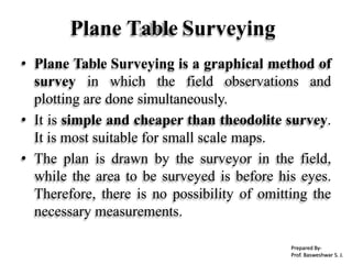
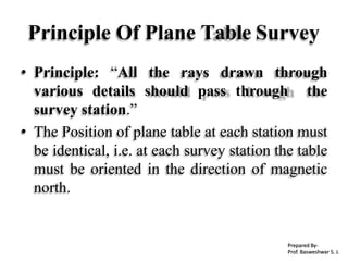
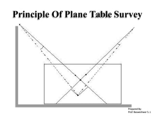
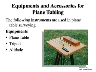
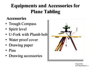
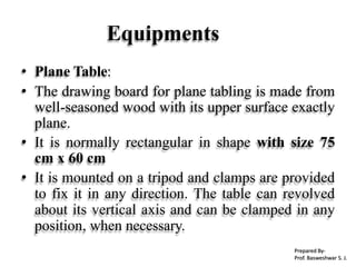
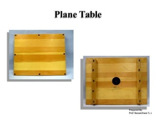
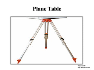
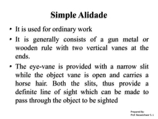
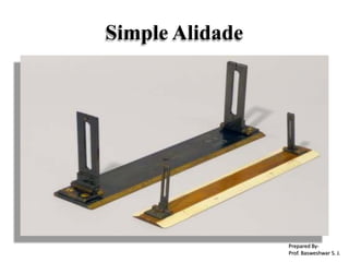
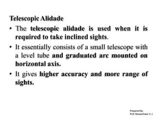
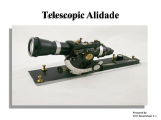
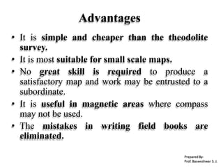
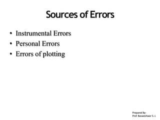
Plane Table Survey
Prepared By-
Prof. Basweshwar S. J.
• Plane Table Surveying
• Principle
• Instruments
• Setting up the plane table
• Methods of plane tabling
• Advantages & Disadvantages
• sources of Errors.
Content
Prepared By-
Prof. Basweshwar S. J.
Plane Table Surveying
• Plane Table Surveying is a graphical method of
survey in which the field observations and
plotting are done simultaneously.
• It is simple and cheaper than theodolite survey.
It is most suitable for small scale maps.
• The plan is drawn by the surveyor in the field,
while the area to be surveyed is before his eyes.
Therefore, there is no possibility of omitting the
necessary measurements.
Prepared By-
Prof. Basweshwar S. J.
Principle Of Plane Table Survey
• Principle: “All the rays drawn through
various details should pass through the
survey station.”
• The Position of plane table at each station must
be identical, i.e. at each survey station the table
must be oriented in the direction of magnetic
north.
Prepared By-
Prof. Basweshwar S. J.
Principle Of Plane Table Survey
Prepared By-
Prof. Basweshwar S. J.
Equipments and Accessories for
Plane Tabling
The following instruments are used in plane
table surveying.
Equipments
• Plane Table
• Tripod
• Alidade
Prepared By-
Prof. Basweshwar S. J.
Equipments and Accessories for
Plane Tabling
Accessories
• Trough Compass
• Spirit level
• U-Fork with Plumb bob
• Water proof cover
• Drawing paper
• Pins
• Drawing accessories
Prepared By-
Prof. Basweshwar S. J.
Equipments
• Plane Table:
• The drawing board for plane tabling is made from
well-seasoned wood with its upper surface exactly
plane.
• It is normally rectangular in shape with size 75
cm x 60 cm
• It is mounted on a tripod and clamps are provided
to fix it in any direction. The table can revolved
about its vertical axis and can be clamped in any
position, when necessary.
Prepared By-
Prof. Basweshwar S. J.
Plane Table
Prepared By-
Prof. Basweshwar S. J.
Plane Table
Prepared By-
Prof. Basweshwar S. J.
• The plane table is mounted on a tripod
• The tripod is generally of open frame type,
combined rigidity with lightness. The tripod
may be made to fold for convenience of
transportation.
• Tripod is provided with three foot screws at its
top for leveling of the plane table.
Tripod
Prepared By-
Prof. Basweshwar S. J.
Tripod
Prepared By-
Prof. Basweshwar S. J.
Alidade
• The alidade is useful for establishing a line of
sight.
• Two Types of alidade are used.
1. Simple alidade
2. Telescopic alidade
Prepared By-
Prof. Basweshwar S. J.
Simple Alidade
• It is used for ordinary work
• It is generally consists of a gun metal or
wooden rule with two vertical vanes at the
ends.
• The eye-vane is provided with a narrow slit
while the object vane is open and carries a
horse hair. Both the slits, thus provide a
definite line of sight which can be made to
pass through the object to be sighted
Prepared By-
Prof. Basweshwar S. J.
Simple Alidade
Prepared By-
Prof. Basweshwar S. J.
Simple Alidade
• To draw the rays, one of the edge of alidade is
beveled and this perfectly smooth working
edge is known as the fiducially edge.
• The fiducially edge is graduated to facilitate
the plotting of distances to a scale.
Prepared By-
Prof. Basweshwar S. J.
TelescopicAlidade
• The telescopic alidade is used when it is
required to take inclined sights.
• It essentially consists of a small telescope with
a level tube and graduated arc mounted on
horizontal axis.
• It gives higher accuracy and more range of
sights.
Prepared By-
Prof. Basweshwar S. J.
Telescopic Alidade
Prepared By-
Prof. Basweshwar S. J.
Telescopic Alidade
Prepared By-
Prof. Basweshwar S. J.
Accessories
Trough Compass
• The trough compass is required for drawing
the line showing magnetic meridian on the
paper. It is used to orient the table to the
magnetic meridian.
• When the freely suspended needle shows 00
at each end, a line is drawn on the drawing
paper which represents the magnetic north.
Prepared By-
Prof. Basweshwar S. J.
Trough Compass
Prepared By-
Prof. Basweshwar S. J.
Spirit Level
• A Spirit Level is used for ascertaining If the
table is properly level.
• The Table is leveled by placing the level on
the board in two positions at right angles
and getting the bubble central in both
positions.
Prepared By-
Prof. Basweshwar S. J.
Spirit Level
Prepared By-
Prof. Basweshwar S. J.
U-Fork With Plumb bob
• U-fork with plumb bob is used for centering
the table over the point or station occupied by
the plane table when the plotted position of
that point is already on the sheet.
• Also, in the beginning of the work, it is used
for transferring the ground point on the
sheet.
Prepared By-
Prof. Basweshwar S. J.
U-Fork With Plumb Bob
Prepared By-
Prof. Basweshwar S. J.
Water Proof Cover
• An umbrella is used to protect the drawing
paper from rain.
Prepared By-
Prof. Basweshwar S. J.
Drawing Paper
• Drawing paper is used for plotting the ground
details.
Prepared By-
Prof. Basweshwar S. J.
Setting Up the Planetable
i. Fixing the plane table on the tripod stand
ii. Leveling the table
iii. Centering the table
iv. Marking the North-line
v. Orientation
1. Orientation by magnetic needle
2. Orientation by backsighting
Prepared By-
Prof. Basweshwar S. J.
Methods Of PlaneTabling
1. Radiation
2. Intersection
3. Traversing
4. Resection
– Special Methods of Resection
I. Compass Method
II. Back-ray Method
III. Two-point problem
IV. Three-point problem
Prepared By-
Prof. Basweshwar S. J.
RadiationMethod
Itrequires the plane table to occupy a single station.
Orientation table is notrequired.
Toconduct the survey of an area ,the table is kept at aconvenient station P
commanding a full view of the area to be surveyed.
Prepared By-
Prof. Basweshwar S. J.
IntersectionMethod
This method requires setting the table up at minimum of two stations.
Orientation is essential and be can done by back sighting.
Twostation P and Q are selected so that they command a full view of
the area to besurveyed.
Prepared By-
Prof. Basweshwar S. J.
TraversingMethod
This method is used to connect the two or more stations , however it is
similar to the compass traversing but are done simultaneously.
Traversingis a method of surveying where by a series of lines aresurveyed.
Traversemay be open or closedone.
Prepared By-
Prof. Basweshwar S. J.
Re-SectionMethod
This is the method of orienting the table. A characteristic feature of resection is that
rather thanthe objective is to plot the station occupied by the table on the sheet
obtaining the other stations or plotting details.
Two method of orienting thetable.
Method of back sighting.
Method using troughcompass.
Prepared By-
Prof. Basweshwar S. J.
TWO POINT PROBLEM
Prepared By-
Prof. Basweshwar S. J.
Advantages and Disadvantages of
Plane Table Surveying
Advantages:
• The plan is drawn by the surveyor himself
while the area to be surveyed is before his
eyes. Therefore, there is no possibility of
omitting the necessary measurements.
• The surveyor Can compare the plotted work
with the actual features of the area.
Prepared By-
Prof. Basweshwar S. J.
Advantages
• It is simple and cheaper than the theodolite
survey.
• It is most suitable for small scale maps.
• No great skill is required to produce a
satisfactory map and work may be entrusted to a
subordinate.
• It is useful in magnetic areas where compass
may not be used.
• The mistakes in writing field books are
eliminated.
Prepared By-
Prof. Basweshwar S. J.
Disadvantages
Disadvantages (Limitations):
• It is not intended for very accurate work.
• It is not suitable in monsoon.
• It is essentially a tropical instrument.
• Due to heaviness, it is inconvenient to
transport.
• Since there are so many accessories, there is
likelihood of them being lost.
Prepared By-
Prof. Basweshwar S. J.
Sources ofErrors
• Instrumental Errors
• Personal Errors
• Errors of plotting
Prepared By-
Prof. Basweshwar S. J.

Module-III SURVEYING-I [BTCVC304]

  • 1.
    Plane Table Survey PreparedBy- Prof. Basweshwar S. J.
  • 2.
    • Plane TableSurveying • Principle • Instruments • Setting up the plane table • Methods of plane tabling • Advantages & Disadvantages • sources of Errors. Content Prepared By- Prof. Basweshwar S. J.
  • 3.
    Plane Table Surveying •Plane Table Surveying is a graphical method of survey in which the field observations and plotting are done simultaneously. • It is simple and cheaper than theodolite survey. It is most suitable for small scale maps. • The plan is drawn by the surveyor in the field, while the area to be surveyed is before his eyes. Therefore, there is no possibility of omitting the necessary measurements. Prepared By- Prof. Basweshwar S. J.
  • 4.
    Principle Of PlaneTable Survey • Principle: “All the rays drawn through various details should pass through the survey station.” • The Position of plane table at each station must be identical, i.e. at each survey station the table must be oriented in the direction of magnetic north. Prepared By- Prof. Basweshwar S. J.
  • 5.
    Principle Of PlaneTable Survey Prepared By- Prof. Basweshwar S. J.
  • 6.
    Equipments and Accessoriesfor Plane Tabling The following instruments are used in plane table surveying. Equipments • Plane Table • Tripod • Alidade Prepared By- Prof. Basweshwar S. J.
  • 7.
    Equipments and Accessoriesfor Plane Tabling Accessories • Trough Compass • Spirit level • U-Fork with Plumb bob • Water proof cover • Drawing paper • Pins • Drawing accessories Prepared By- Prof. Basweshwar S. J.
  • 8.
    Equipments • Plane Table: •The drawing board for plane tabling is made from well-seasoned wood with its upper surface exactly plane. • It is normally rectangular in shape with size 75 cm x 60 cm • It is mounted on a tripod and clamps are provided to fix it in any direction. The table can revolved about its vertical axis and can be clamped in any position, when necessary. Prepared By- Prof. Basweshwar S. J.
  • 9.
  • 10.
  • 11.
    • The planetable is mounted on a tripod • The tripod is generally of open frame type, combined rigidity with lightness. The tripod may be made to fold for convenience of transportation. • Tripod is provided with three foot screws at its top for leveling of the plane table. Tripod Prepared By- Prof. Basweshwar S. J.
  • 12.
  • 13.
    Alidade • The alidadeis useful for establishing a line of sight. • Two Types of alidade are used. 1. Simple alidade 2. Telescopic alidade Prepared By- Prof. Basweshwar S. J.
  • 14.
    Simple Alidade • Itis used for ordinary work • It is generally consists of a gun metal or wooden rule with two vertical vanes at the ends. • The eye-vane is provided with a narrow slit while the object vane is open and carries a horse hair. Both the slits, thus provide a definite line of sight which can be made to pass through the object to be sighted Prepared By- Prof. Basweshwar S. J.
  • 15.
  • 16.
    Simple Alidade • Todraw the rays, one of the edge of alidade is beveled and this perfectly smooth working edge is known as the fiducially edge. • The fiducially edge is graduated to facilitate the plotting of distances to a scale. Prepared By- Prof. Basweshwar S. J.
  • 17.
    TelescopicAlidade • The telescopicalidade is used when it is required to take inclined sights. • It essentially consists of a small telescope with a level tube and graduated arc mounted on horizontal axis. • It gives higher accuracy and more range of sights. Prepared By- Prof. Basweshwar S. J.
  • 18.
  • 19.
  • 20.
    Accessories Trough Compass • Thetrough compass is required for drawing the line showing magnetic meridian on the paper. It is used to orient the table to the magnetic meridian. • When the freely suspended needle shows 00 at each end, a line is drawn on the drawing paper which represents the magnetic north. Prepared By- Prof. Basweshwar S. J.
  • 21.
  • 22.
    Spirit Level • ASpirit Level is used for ascertaining If the table is properly level. • The Table is leveled by placing the level on the board in two positions at right angles and getting the bubble central in both positions. Prepared By- Prof. Basweshwar S. J.
  • 23.
  • 24.
    U-Fork With Plumbbob • U-fork with plumb bob is used for centering the table over the point or station occupied by the plane table when the plotted position of that point is already on the sheet. • Also, in the beginning of the work, it is used for transferring the ground point on the sheet. Prepared By- Prof. Basweshwar S. J.
  • 25.
    U-Fork With PlumbBob Prepared By- Prof. Basweshwar S. J.
  • 26.
    Water Proof Cover •An umbrella is used to protect the drawing paper from rain. Prepared By- Prof. Basweshwar S. J.
  • 27.
    Drawing Paper • Drawingpaper is used for plotting the ground details. Prepared By- Prof. Basweshwar S. J.
  • 28.
    Setting Up thePlanetable i. Fixing the plane table on the tripod stand ii. Leveling the table iii. Centering the table iv. Marking the North-line v. Orientation 1. Orientation by magnetic needle 2. Orientation by backsighting Prepared By- Prof. Basweshwar S. J.
  • 29.
    Methods Of PlaneTabling 1.Radiation 2. Intersection 3. Traversing 4. Resection – Special Methods of Resection I. Compass Method II. Back-ray Method III. Two-point problem IV. Three-point problem Prepared By- Prof. Basweshwar S. J.
  • 30.
    RadiationMethod Itrequires the planetable to occupy a single station. Orientation table is notrequired. Toconduct the survey of an area ,the table is kept at aconvenient station P commanding a full view of the area to be surveyed. Prepared By- Prof. Basweshwar S. J.
  • 31.
    IntersectionMethod This method requiressetting the table up at minimum of two stations. Orientation is essential and be can done by back sighting. Twostation P and Q are selected so that they command a full view of the area to besurveyed. Prepared By- Prof. Basweshwar S. J.
  • 32.
    TraversingMethod This method isused to connect the two or more stations , however it is similar to the compass traversing but are done simultaneously. Traversingis a method of surveying where by a series of lines aresurveyed. Traversemay be open or closedone. Prepared By- Prof. Basweshwar S. J.
  • 33.
    Re-SectionMethod This is themethod of orienting the table. A characteristic feature of resection is that rather thanthe objective is to plot the station occupied by the table on the sheet obtaining the other stations or plotting details. Two method of orienting thetable. Method of back sighting. Method using troughcompass. Prepared By- Prof. Basweshwar S. J.
  • 34.
    TWO POINT PROBLEM PreparedBy- Prof. Basweshwar S. J.
  • 35.
    Advantages and Disadvantagesof Plane Table Surveying Advantages: • The plan is drawn by the surveyor himself while the area to be surveyed is before his eyes. Therefore, there is no possibility of omitting the necessary measurements. • The surveyor Can compare the plotted work with the actual features of the area. Prepared By- Prof. Basweshwar S. J.
  • 36.
    Advantages • It issimple and cheaper than the theodolite survey. • It is most suitable for small scale maps. • No great skill is required to produce a satisfactory map and work may be entrusted to a subordinate. • It is useful in magnetic areas where compass may not be used. • The mistakes in writing field books are eliminated. Prepared By- Prof. Basweshwar S. J.
  • 37.
    Disadvantages Disadvantages (Limitations): • Itis not intended for very accurate work. • It is not suitable in monsoon. • It is essentially a tropical instrument. • Due to heaviness, it is inconvenient to transport. • Since there are so many accessories, there is likelihood of them being lost. Prepared By- Prof. Basweshwar S. J.
  • 38.
    Sources ofErrors • InstrumentalErrors • Personal Errors • Errors of plotting Prepared By- Prof. Basweshwar S. J.