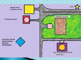
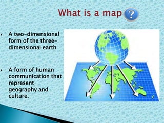
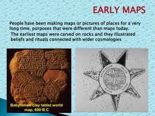
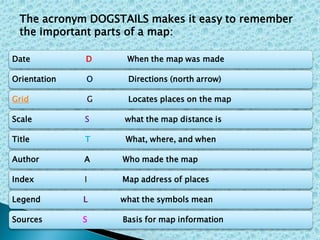
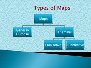
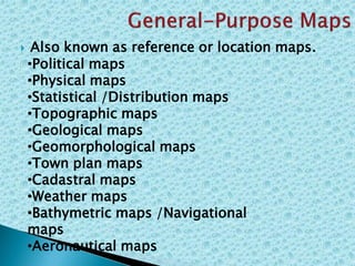
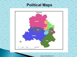
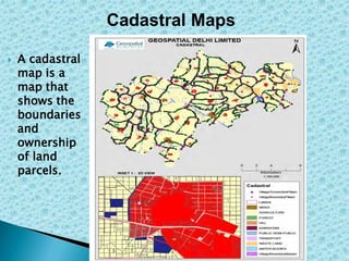
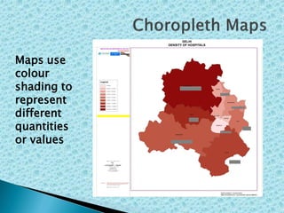
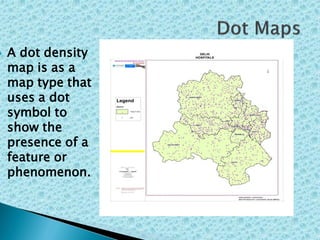
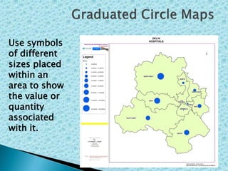
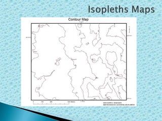
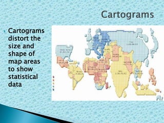
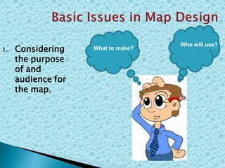
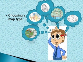
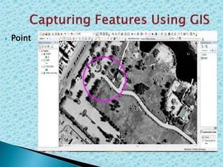
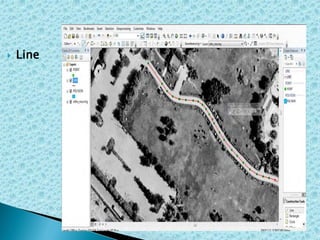
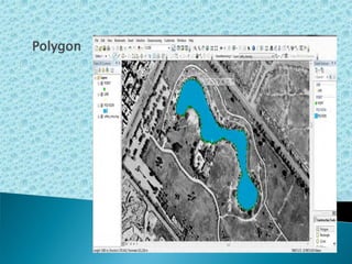
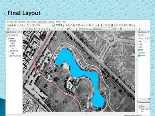
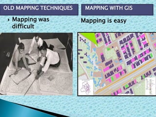
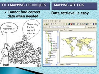
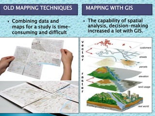
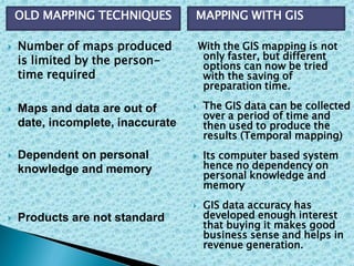
 Introduction to maps
 What is a map?
 Uses of maps
 Map elements
 Types of maps
 Map making
 Basic Issues in Map Design
 Map making process
 GIS In Map Making
 A two-dimensional
form of the three-
dimensional earth
 A form of human
communication that
represent
geography and
culture.
The earliest maps were carved on rocks and they illustrated
beliefs and rituals connected with wider cosmologies.
EARLY MAPS
People have been making maps or pictures of places for a very
long time, purposes that were different than maps today.
Babylonian clay tablet world
map, 600 B.C
 Some represented a way of
seeing the world , for
example, the ancient T-O
maps used by Jews in
Jerusalem were intended to
show Jerusalem as the holy
centre of the world.
.
 The fool's cap world map,
about 1590. Maps are
human representations of
the world, as seen through
the eyes of a clown in this
example.
 As nations
expanded
military
ventures
demanded,
the need for
maps
became
more
evident.
Why did people need maps?
Source: WHKMLA Historical Maps
 To make a
very large
area look
small and
understand
able.
DELHI
Source: GSDL
Why people need maps now?
 Maps are
used as
tools for
planning
(i.e. dams,
highways,
urban
developmen
t).
...Why people need maps?
 To help
us find
our way
to
different
areas.
 Show us
where
major
places
are.
...Why people need maps?
 To Show us
distribution
of resources
 Bring out
relationship
amongst
geographic
elements.
...Why people need maps?
 Maps have several elements, which are necessary
to read and understand them .
Date D When the map was made
Orientation O Directions (north arrow)
Grid G Locates places on the map
Scale S what the map distance is
Title T What, where, and when
Author A Who made the map
Index I Map address of places
Legend L what the symbols mean
Sources S Basis for map information
The acronym DOGSTAILS makes it easy to remember
the important parts of a map:
Maps
General-
Purpose
Thematic
Qualitative Quantitative
 Also known as reference or location maps.
•Political maps
•Physical maps
•Statistical /Distribution maps
•Topographic maps
•Geological maps
•Geomorphological maps
•Town plan maps
•Cadastral maps
•Weather maps
•Bathymetric maps /Navigational
maps
•Aeronautical maps
Political Maps
Source:India Maps site
Cadastral Maps
 A cadastral
map is a
map that
shows the
boundaries
and
ownership
of land
parcels.
 Also known as (Special Purpose) maps.
Also known as descriptive maps ,are
 Region Map : In which geographic shapes
have been grouped into larger regions, with
each region appearing as a single entity
(usually with the same colour).
 Path Map :map that shows paths between
locations, or directions of flow.
 Facility Map: map that shows the locations of
facilities using point symbols.
 Resource Map : map which shows the
locations of resources.
 indicate the quantity of a data attribute at
different locations on a map.
Maps use
colour
shading to
represent
different
quantities
or values
 A dot density
map is as a
map type that
uses a dot
symbol to
show the
presence of a
feature or
phenomenon.
Use symbols
of different
sizes placed
within an
area to show
the value or
quantity
associated
with it.
 Cartograms
distort the
size and
shape of
map areas
to show
statistical
data
1. Considering
the purpose
of and
audience for
the map.
What to make?
Who will use?
 Choosing a
map type
 Choosing
appropriate
map
projection
 Selecting
a title that
represents
what is
shown
India
Resource
Map?
Resource
Map of
India?
Resources
In India?
 Selecting and
placing text
Title
Date
Map
Source
1. Designing
an overall
layout for
easy
understand
ing
There are five important steps to produce a map
of the Earth's Surface. These are:
Map making process
1.A reference system which is used to
describe the locations of points on the
surface of the Earth.
For maps of large areas of the Earth
this would be latitude/longitude and
for simpler 'sketches' or maps of local
areas this would be a grid.
2. A Datum which defines the
geometry/mathematics of how to
transfer this coordinate system
onto the surface of the Earth.
3. Thirdly, a measurement system
which is used calculate the
coordinates of points on the
surface of the Earth.
4. A projection which allows the
coordinates which have been
calculated using a measuring
system, to be displayed on a flat
piece of paper.
5. The Map Maker's Art.
GIS In Map Making
 Point
 Line
Polygon
 Final Layout
 Mapping was
difficult
Mapping is easy
OLD MAPPING TECHNIQUES MAPPING WITH GIS
 Cannot find correct
data when needed
Searching
for the
correct
map sir…
Data retrieval is easy
OLD MAPPING TECHNIQUES MAPPING WITH GIS
 Combining data and
maps for a study is time-
consuming and difficult
 The capability of spatial
analysis, decision-making
increased a lot with GIS.
OLD MAPPING TECHNIQUES MAPPING WITH GIS
 Number of maps produced
is limited by the person-
time required
 Maps and data are out of
date, incomplete, inaccurate
 Dependent on personal
knowledge and memory
 Products are not standard
With the GIS mapping is not
only faster, but different
options can now be tried
with the saving of
preparation time.
 The GIS data can be collected
over a period of time and
then used to produce the
results (Temporal mapping)
 Its computer based system
hence no dependency on
personal knowledge and
memory
 GIS data accuracy has
developed enough interest
that buying it makes good
business sense and helps in
revenue generation.
OLD MAPPING TECHNIQUES MAPPING WITH GIS
 In Future any design and implementation of the new
development review system project cannot be
discussed without the mention of GIS and the
necessity that this new review system be linked to
its database.
 GIS has proven to be a valuable tool for the persons
and organizational units.
 Implementation of GIS technology can mature and
adapt to the current trends in the industry (i.e., 3D)
and continue to serve the Country.
 As GIS increasingly penetrates a number of
academic subjects and integrates further into
mainstream business, the need to build close
relationships between academia and the business
community is stronger than ever.
MapMaker.pdf

MapMaker.pdf

  • 2.
     Introduction tomaps  What is a map?  Uses of maps  Map elements  Types of maps  Map making  Basic Issues in Map Design  Map making process  GIS In Map Making
  • 8.
     A two-dimensional formof the three- dimensional earth  A form of human communication that represent geography and culture.
  • 10.
    The earliest mapswere carved on rocks and they illustrated beliefs and rituals connected with wider cosmologies. EARLY MAPS People have been making maps or pictures of places for a very long time, purposes that were different than maps today. Babylonian clay tablet world map, 600 B.C
  • 11.
     Some representeda way of seeing the world , for example, the ancient T-O maps used by Jews in Jerusalem were intended to show Jerusalem as the holy centre of the world. .  The fool's cap world map, about 1590. Maps are human representations of the world, as seen through the eyes of a clown in this example.
  • 12.
     As nations expanded military ventures demanded, theneed for maps became more evident. Why did people need maps? Source: WHKMLA Historical Maps
  • 13.
     To makea very large area look small and understand able. DELHI Source: GSDL Why people need maps now?
  • 14.
     Maps are usedas tools for planning (i.e. dams, highways, urban developmen t). ...Why people need maps?
  • 15.
     To help usfind our way to different areas.  Show us where major places are. ...Why people need maps?
  • 16.
    ...Why people needmaps?  To Show us distribution of resources
  • 17.
  • 18.
     Maps haveseveral elements, which are necessary to read and understand them .
  • 19.
    Date D Whenthe map was made Orientation O Directions (north arrow) Grid G Locates places on the map Scale S what the map distance is Title T What, where, and when Author A Who made the map Index I Map address of places Legend L what the symbols mean Sources S Basis for map information The acronym DOGSTAILS makes it easy to remember the important parts of a map:
  • 20.
  • 21.
     Also knownas reference or location maps. •Political maps •Physical maps •Statistical /Distribution maps •Topographic maps •Geological maps •Geomorphological maps •Town plan maps •Cadastral maps •Weather maps •Bathymetric maps /Navigational maps •Aeronautical maps
  • 22.
  • 23.
    Cadastral Maps  Acadastral map is a map that shows the boundaries and ownership of land parcels.
  • 24.
     Also knownas (Special Purpose) maps.
  • 25.
    Also known asdescriptive maps ,are  Region Map : In which geographic shapes have been grouped into larger regions, with each region appearing as a single entity (usually with the same colour).  Path Map :map that shows paths between locations, or directions of flow.  Facility Map: map that shows the locations of facilities using point symbols.  Resource Map : map which shows the locations of resources.
  • 26.
     indicate thequantity of a data attribute at different locations on a map.
  • 27.
  • 28.
     A dotdensity map is as a map type that uses a dot symbol to show the presence of a feature or phenomenon.
  • 29.
    Use symbols of different sizesplaced within an area to show the value or quantity associated with it.
  • 31.
     Cartograms distort the sizeand shape of map areas to show statistical data
  • 33.
    1. Considering the purpose ofand audience for the map. What to make? Who will use?
  • 34.
  • 35.
  • 36.
     Selecting a titlethat represents what is shown India Resource Map? Resource Map of India? Resources In India?
  • 37.
     Selecting and placingtext Title Date Map Source
  • 38.
    1. Designing an overall layoutfor easy understand ing
  • 39.
    There are fiveimportant steps to produce a map of the Earth's Surface. These are: Map making process 1.A reference system which is used to describe the locations of points on the surface of the Earth. For maps of large areas of the Earth this would be latitude/longitude and for simpler 'sketches' or maps of local areas this would be a grid.
  • 40.
    2. A Datumwhich defines the geometry/mathematics of how to transfer this coordinate system onto the surface of the Earth. 3. Thirdly, a measurement system which is used calculate the coordinates of points on the surface of the Earth. 4. A projection which allows the coordinates which have been calculated using a measuring system, to be displayed on a flat piece of paper.
  • 41.
    5. The MapMaker's Art.
  • 42.
    GIS In MapMaking
  • 43.
  • 44.
  • 45.
  • 46.
  • 47.
     Mapping was difficult Mappingis easy OLD MAPPING TECHNIQUES MAPPING WITH GIS
  • 48.
     Cannot findcorrect data when needed Searching for the correct map sir… Data retrieval is easy OLD MAPPING TECHNIQUES MAPPING WITH GIS
  • 49.
     Combining dataand maps for a study is time- consuming and difficult  The capability of spatial analysis, decision-making increased a lot with GIS. OLD MAPPING TECHNIQUES MAPPING WITH GIS
  • 50.
     Number ofmaps produced is limited by the person- time required  Maps and data are out of date, incomplete, inaccurate  Dependent on personal knowledge and memory  Products are not standard With the GIS mapping is not only faster, but different options can now be tried with the saving of preparation time.  The GIS data can be collected over a period of time and then used to produce the results (Temporal mapping)  Its computer based system hence no dependency on personal knowledge and memory  GIS data accuracy has developed enough interest that buying it makes good business sense and helps in revenue generation. OLD MAPPING TECHNIQUES MAPPING WITH GIS
  • 51.
     In Futureany design and implementation of the new development review system project cannot be discussed without the mention of GIS and the necessity that this new review system be linked to its database.
  • 52.
     GIS hasproven to be a valuable tool for the persons and organizational units.  Implementation of GIS technology can mature and adapt to the current trends in the industry (i.e., 3D) and continue to serve the Country.  As GIS increasingly penetrates a number of academic subjects and integrates further into mainstream business, the need to build close relationships between academia and the business community is stronger than ever.