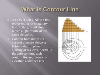
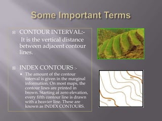
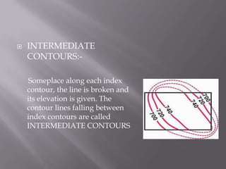
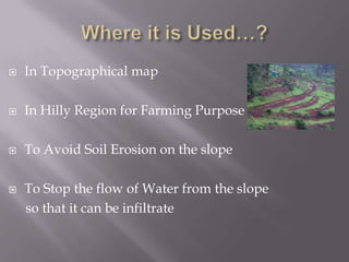
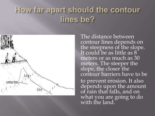
 A CONTOUR LINE is a line
representing an imaginary
line on the ground along
which all points are at the
same elevation.
 Contour lines indicate a
vertical distance above or
below a datum plane.
Starting at sea level, normally
the zero contour, each
contour line represents an
elevation above sea level
 CONTOUR INTERVAL:-
It is the vertical distance
between adjacent contour
lines.
 INDEX CONTOURS :-
 The amount of the contour
interval is given in the marginal
information. On most maps, the
contour lines are printed in
brown. Starting at zero elevation,
every fifth contour line is drawn
with a heavier line. These are
known as INDEX CONTOURS.
 INTERMEDIATE
CONTOURS:-
Someplace along each index
contour, the line is broken and
its elevation is given. The
contour lines falling between
index contours are called
INTERMEDIATE CONTOURS
 In Topographical map
 In Hilly Region for Farming Purpose
 To Avoid Soil Erosion on the slope
 To Stop the flow of Water from the slope
so that it can be infiltrate
You can mark contour lines out with a home made
A-frame.
1. MAKING AN A-FRAME
 2 pieces of wood, approximately 5cm x 2.5cm and
2m long
 1 piece of wood, 1m long
 3 nails or screws, 5cm long (if not available, you
can use string instead)
 a short length of string
 a weight (for example a stone)
1. Lay the two longer pieces of
wood on the ground, with
their ends touching and the
other ends 2m away from
each other. Fasten the 2
pieces together at one end
with a nail or screw. If you
have not got nails or screws,
cut notches and use string to
bind the two ends together.
Fix them loosely at first.
2. Fix the third piece of wood
(1m) at exactly the middle
of each of the long pieces.
When the3 pieces are in
position
3. Hang a string down from
the tip of the A frame, and
attach a weight to it, so
that it swings below the
cross-bar
4. Calibrate the A-frame by placing
it upright on ground you know
is level. When the stone stops
swinging, mark the position
where the string crosses the
crossbar. Turn the A frame
around, putting the legs in
exactly the opposite position,
and measure the centre-point
again. If it is in the same place,
then it is the level ground marker
Start near the top of the
slope. Stand on the
hillside with the
A-frame, adjusting it
until you find level
ground as indicated
when the weighted
string hangs at the level
ground marker.
The distance between
contour lines depends on
the steepness of the slope.
It could be as little as 8
meters or as much as 30
meters. The steeper the
slope, the closer the
contour barriers have to be
to prevent erosion. It also
depends upon the amount
of rain that falls, and on
what you are going to do
with the land.
Lines are
with respect
to the Slope
 The Major advantage of
Contour lines is in the field
Agriculture..
 It is very necessary to stop
the flow of water on the
slope so that water can be
infiltrate
 By this we can stop the soil
erosion
 Provide water to crops during drought years
 Trap nutrients washed away from the field
 Can be converted to compost pits
 Reduce siltation to river systems down slope
 Can be used to grow crops
 Can be used for fish-farming
contourlines-130527092046-phpapp02.pdf

contourlines-130527092046-phpapp02.pdf

  • 3.
     A CONTOURLINE is a line representing an imaginary line on the ground along which all points are at the same elevation.  Contour lines indicate a vertical distance above or below a datum plane. Starting at sea level, normally the zero contour, each contour line represents an elevation above sea level
  • 4.
     CONTOUR INTERVAL:- Itis the vertical distance between adjacent contour lines.  INDEX CONTOURS :-  The amount of the contour interval is given in the marginal information. On most maps, the contour lines are printed in brown. Starting at zero elevation, every fifth contour line is drawn with a heavier line. These are known as INDEX CONTOURS.
  • 5.
     INTERMEDIATE CONTOURS:- Someplace alongeach index contour, the line is broken and its elevation is given. The contour lines falling between index contours are called INTERMEDIATE CONTOURS
  • 6.
     In Topographicalmap  In Hilly Region for Farming Purpose  To Avoid Soil Erosion on the slope  To Stop the flow of Water from the slope so that it can be infiltrate
  • 7.
    You can markcontour lines out with a home made A-frame. 1. MAKING AN A-FRAME  2 pieces of wood, approximately 5cm x 2.5cm and 2m long  1 piece of wood, 1m long  3 nails or screws, 5cm long (if not available, you can use string instead)  a short length of string  a weight (for example a stone)
  • 8.
    1. Lay thetwo longer pieces of wood on the ground, with their ends touching and the other ends 2m away from each other. Fasten the 2 pieces together at one end with a nail or screw. If you have not got nails or screws, cut notches and use string to bind the two ends together. Fix them loosely at first.
  • 9.
    2. Fix thethird piece of wood (1m) at exactly the middle of each of the long pieces. When the3 pieces are in position 3. Hang a string down from the tip of the A frame, and attach a weight to it, so that it swings below the cross-bar
  • 10.
    4. Calibrate theA-frame by placing it upright on ground you know is level. When the stone stops swinging, mark the position where the string crosses the crossbar. Turn the A frame around, putting the legs in exactly the opposite position, and measure the centre-point again. If it is in the same place, then it is the level ground marker
  • 11.
    Start near thetop of the slope. Stand on the hillside with the A-frame, adjusting it until you find level ground as indicated when the weighted string hangs at the level ground marker.
  • 12.
    The distance between contourlines depends on the steepness of the slope. It could be as little as 8 meters or as much as 30 meters. The steeper the slope, the closer the contour barriers have to be to prevent erosion. It also depends upon the amount of rain that falls, and on what you are going to do with the land.
  • 13.
  • 14.
     The Majoradvantage of Contour lines is in the field Agriculture..  It is very necessary to stop the flow of water on the slope so that water can be infiltrate  By this we can stop the soil erosion
  • 15.
     Provide waterto crops during drought years  Trap nutrients washed away from the field  Can be converted to compost pits  Reduce siltation to river systems down slope  Can be used to grow crops  Can be used for fish-farming