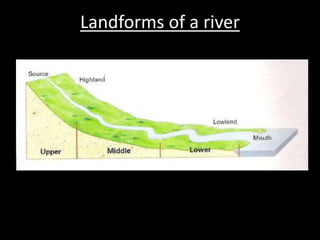
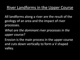
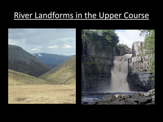
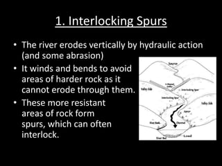
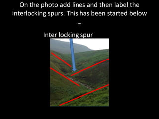
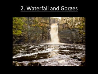
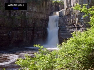
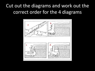
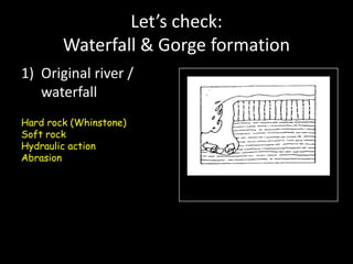
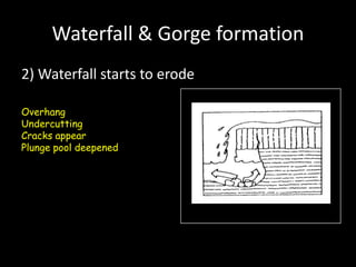
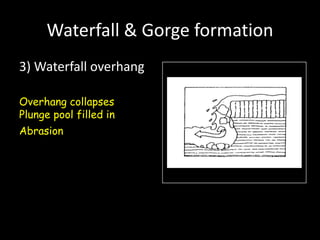
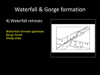
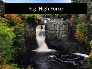
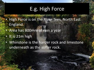
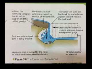
Landforms of a river
River Landforms in the Upper Course
All landforms along a river are the result of the
geology of an area and the impact of river
processes.
What are the dominant river processes in the
upper course?
Erosion is the main process in the upper course
and cuts down vertically to form a V shaped
valley.
River Landforms in the Upper Course
1. Interlocking Spurs
• The river erodes vertically by hydraulic action
(and some abrasion)
• It winds and bends to avoid
areas of harder rock as it
cannot erode through them.
• These more resistant
areas of rock form
spurs, which can often
interlock.
1. Interlocking Spurs
• The river erodes vertically by hydraulic action
(and some abrasion)
• It winds and bends to avoid
areas of harder rock as it
cannot erode through them.
• These more resistant
areas of rock form
spurs, which can often
interlock.
On the photo add lines and then label the
interlocking spurs. This has been started below
…
Inter locking spur
2. Waterfall and Gorges
Waterfall video
here
Cut out the diagrams and work out the
correct order for the 4 diagrams
a
b
c d
Let’s check:
Waterfall & Gorge formation
1) Original river /
waterfall
Hard rock (Whinstone)
Soft rock
Hydraulic action
Abrasion
Waterfall & Gorge formation
2) Waterfall starts to erode
Overhang
Undercutting
Cracks appear
Plunge pool deepened
Waterfall & Gorge formation
3) Waterfall overhang
Overhang collapses
Plunge pool filled in
Abrasion
Waterfall & Gorge formation
4) Waterfall retreats
Waterfall retreats upstream
Gorge forms
Steep sides
E.g. High Force
E.g. High Force
• High Force is on the River Tees, North East
England.
• Area has 800mm of rain a year
• It is 21m high
• Whinstone is the harder rock and limestone
underneath as the softer rock.
TASK:
• In 2/3s use the play-doh to make a waterfall!
• Make sure that you label it’s features clearly
and EXPLAIN how it forms, (E.G. GRAVITY,
OVERHANG, HYDRAULIC ACTION)
• Take a photo on your iPad and upload it on to
Showbie so I can see it – print off at home and
stick into your book too
Homework
• Find and print off a photo of a waterall (be
selective as you want a good photo e.g. of High
Force Waterfall) and label the following parts of it
by hand and stick it into your exercise book
• Less Resistant Rock
• Plunge Pool
• Resistant rock
• Undercutting
• Overhang
• Gorge
Watch this
• Watch all the 7 episodes on the YouTube
playlist below about the river Tees in North
East England.
• https://www.youtube.com/watch?v=j3m0Hzy
NJE0&list=PL4bINZBFxm3lSAa8d9eLEMhF6pv
ml0xz1

L3 ap upper course features

  • 2.
  • 3.
    River Landforms inthe Upper Course All landforms along a river are the result of the geology of an area and the impact of river processes. What are the dominant river processes in the upper course? Erosion is the main process in the upper course and cuts down vertically to form a V shaped valley.
  • 4.
    River Landforms inthe Upper Course
  • 5.
    1. Interlocking Spurs •The river erodes vertically by hydraulic action (and some abrasion) • It winds and bends to avoid areas of harder rock as it cannot erode through them. • These more resistant areas of rock form spurs, which can often interlock.
  • 6.
    1. Interlocking Spurs •The river erodes vertically by hydraulic action (and some abrasion) • It winds and bends to avoid areas of harder rock as it cannot erode through them. • These more resistant areas of rock form spurs, which can often interlock.
  • 7.
    On the photoadd lines and then label the interlocking spurs. This has been started below … Inter locking spur
  • 8.
  • 9.
  • 10.
    Cut out thediagrams and work out the correct order for the 4 diagrams a b c d
  • 11.
    Let’s check: Waterfall &Gorge formation 1) Original river / waterfall Hard rock (Whinstone) Soft rock Hydraulic action Abrasion
  • 12.
    Waterfall & Gorgeformation 2) Waterfall starts to erode Overhang Undercutting Cracks appear Plunge pool deepened
  • 13.
    Waterfall & Gorgeformation 3) Waterfall overhang Overhang collapses Plunge pool filled in Abrasion
  • 14.
    Waterfall & Gorgeformation 4) Waterfall retreats Waterfall retreats upstream Gorge forms Steep sides
  • 15.
  • 16.
    E.g. High Force •High Force is on the River Tees, North East England. • Area has 800mm of rain a year • It is 21m high • Whinstone is the harder rock and limestone underneath as the softer rock.
  • 19.
    TASK: • In 2/3suse the play-doh to make a waterfall! • Make sure that you label it’s features clearly and EXPLAIN how it forms, (E.G. GRAVITY, OVERHANG, HYDRAULIC ACTION) • Take a photo on your iPad and upload it on to Showbie so I can see it – print off at home and stick into your book too
  • 21.
    Homework • Find andprint off a photo of a waterall (be selective as you want a good photo e.g. of High Force Waterfall) and label the following parts of it by hand and stick it into your exercise book • Less Resistant Rock • Plunge Pool • Resistant rock • Undercutting • Overhang • Gorge
  • 22.
    Watch this • Watchall the 7 episodes on the YouTube playlist below about the river Tees in North East England. • https://www.youtube.com/watch?v=j3m0Hzy NJE0&list=PL4bINZBFxm3lSAa8d9eLEMhF6pv ml0xz1