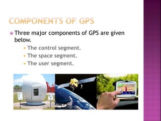
S.JANANI
IV ECE
 Introduction
 The GPS satellite system
 Working of GPS
 Components of a GPS
 Applications
 Advantages and disadvantages
 Conclusion
 GPS was created and realised by US
department of defence(USDOD).
 GPS is a space-based global navigation
satellite(GNSS).
 Used for reliable location and time
information.
 It works in all weather conditions and all
times and day where on or near the earth.
 There is no subscription fee and setup
charges to use GPS.
 GPS is a useful tool for Commerce,Scientific
uses,Tracking and surveillance.
 GPS system is made up of a network of 24
satellites placed into the orbit by the US.
 It is placed 20,000 Km above the earth.
 Travelling speed is roughly 7,000 miles per
hour.
 It’s lifetime is about 10 years and the
replacement are constantly being built and
launched into the orbit.
 Satellite weight is about 2,000 pounds and it
is 17 feet across the solar panels extended.
 It is powered by solar panels.
 They also have back up batteries onboard to
keep them running even in solar eclipse
time,where there is no solar power.
 Small rocket boosters on each satellite keep
them flying in correct path(station keeping).
 The goal of GPS is to determine the User’s
position on earth in three dimensions:east-
west,north-south and vertical.
 GPS uses satellites and computers to
compute positions anywhere on earth.
 It is based on satellite ranging.
 Basic formula used in this process is
Distance=speed * Time.
Geometric Principle:
You can find one’s location if you know
its distance from other, already-known
locations.
Things which need to be determined:
 Time taken by the signals to reach the GPS
receiver.
 The Distance Between Receiver’s Position and
the GPS Satellites.
 SATELLITE RANGING – determining the
position on the earth by measuring the
distance from a group of satellites in space
to the receiver.
 To determine user’s position signals we use
four overhead satellites to determine it’s
position and the time of emission of the
signal.
GPS receivers store this orbit information
for all of the GPS satellites.
A GPS receiver can tell its own position
by using the position data of itself, and
compares that data with 3 or more GPS
satellite.
 By measuring the amount of time taken by
radio signal (the GPS signal) to travel from
the satellite to the receiver.
 GPS receiver has built in microprocessor to
display the location of the user.
 The user’s position is displayed on the unit’s
electronic map.
 Three major components of GPS are given
below.
 The control segment.
 The space segment.
 The user segment.
 The CS consists of following entities:
 Monitor Stations
 Ground Antennas
 Powered by solar cells.
 GPS satellites fly in circular orbits at an
altitude of 20,200 km.
 Falcon Air Force Base in Colorado.
 Cape Canaveral.
 Florida.
 Hawaii.
 Ascension Island in the Atlantic Ocean.
 Diego Garcia Atoll in the Indian Ocean.
 Kwajalein Island in the South Pacific Ocean.
 Ground antennas monitor and
Track the satellites from
horizon to horizon.
 They also transmit correction information to
individual satellites.
 Communicate with the GPS satellites for
command and control purposes.
 The space segment is composed of 24 to 32
satellites in MEO.
 Contains payload adaptors to the boosters
required to launch them into the orbit.
 GPS receivers are generally
Composed of
1.An antenna( tuned to the frequencies
transmitted by the satellites),
2.Receiver-processors, and
3.Highly-stable clock( commonly a crystal
oscillator).
 They can also include a display for showing
location and speed information to the user.
 Surveying : Surveyors use
absolute locations to make
maps and determine
boundaries.
 Missile and Propulsion
guidance.
 Tectonics:GPS enables direct fault motion
measurements in earth quakes.
 Navigation.
 Target tracking.
 Missile guidance.
 Search and rescue.
 Remote sensing.
 Materials used to manufacture GPS are
affordable.
 GPS can provide worldwide, three-
dimensional positions, 24 hours a day, in any
type of weather.
 It uses one way transmission,hence GPS
transmitter is not needed.
 Size is small.
 There must be a relatively clear "line of
sight" between the GPS antenna and four or
more satellites.
 Difficulties may occur while tracking in urban
areas.
 The GPS constellation, like manmade stars in
the sky, can be used for guiding and
navigation.
Global positioning system

Global positioning system

  • 1.
  • 2.
     Introduction  TheGPS satellite system  Working of GPS  Components of a GPS  Applications  Advantages and disadvantages  Conclusion
  • 3.
     GPS wascreated and realised by US department of defence(USDOD).  GPS is a space-based global navigation satellite(GNSS).  Used for reliable location and time information.  It works in all weather conditions and all times and day where on or near the earth.
  • 4.
     There isno subscription fee and setup charges to use GPS.  GPS is a useful tool for Commerce,Scientific uses,Tracking and surveillance.
  • 5.
     GPS systemis made up of a network of 24 satellites placed into the orbit by the US.  It is placed 20,000 Km above the earth.  Travelling speed is roughly 7,000 miles per hour.  It’s lifetime is about 10 years and the replacement are constantly being built and launched into the orbit.
  • 6.
     Satellite weightis about 2,000 pounds and it is 17 feet across the solar panels extended.  It is powered by solar panels.  They also have back up batteries onboard to keep them running even in solar eclipse time,where there is no solar power.  Small rocket boosters on each satellite keep them flying in correct path(station keeping).
  • 7.
     The goalof GPS is to determine the User’s position on earth in three dimensions:east- west,north-south and vertical.  GPS uses satellites and computers to compute positions anywhere on earth.  It is based on satellite ranging.  Basic formula used in this process is Distance=speed * Time.
  • 10.
    Geometric Principle: You canfind one’s location if you know its distance from other, already-known locations. Things which need to be determined:  Time taken by the signals to reach the GPS receiver.  The Distance Between Receiver’s Position and the GPS Satellites.
  • 11.
     SATELLITE RANGING– determining the position on the earth by measuring the distance from a group of satellites in space to the receiver.  To determine user’s position signals we use four overhead satellites to determine it’s position and the time of emission of the signal.
  • 12.
    GPS receivers storethis orbit information for all of the GPS satellites. A GPS receiver can tell its own position by using the position data of itself, and compares that data with 3 or more GPS satellite.  By measuring the amount of time taken by radio signal (the GPS signal) to travel from the satellite to the receiver.
  • 13.
     GPS receiverhas built in microprocessor to display the location of the user.  The user’s position is displayed on the unit’s electronic map.
  • 14.
     Three majorcomponents of GPS are given below.  The control segment.  The space segment.  The user segment.
  • 15.
     The CSconsists of following entities:  Monitor Stations  Ground Antennas  Powered by solar cells.  GPS satellites fly in circular orbits at an altitude of 20,200 km.
  • 16.
     Falcon AirForce Base in Colorado.  Cape Canaveral.  Florida.  Hawaii.  Ascension Island in the Atlantic Ocean.  Diego Garcia Atoll in the Indian Ocean.  Kwajalein Island in the South Pacific Ocean.
  • 17.
     Ground antennasmonitor and Track the satellites from horizon to horizon.  They also transmit correction information to individual satellites.  Communicate with the GPS satellites for command and control purposes.
  • 18.
     The spacesegment is composed of 24 to 32 satellites in MEO.  Contains payload adaptors to the boosters required to launch them into the orbit.
  • 19.
     GPS receiversare generally Composed of 1.An antenna( tuned to the frequencies transmitted by the satellites), 2.Receiver-processors, and 3.Highly-stable clock( commonly a crystal oscillator).  They can also include a display for showing location and speed information to the user.
  • 20.
     Surveying :Surveyors use absolute locations to make maps and determine boundaries.  Missile and Propulsion guidance.
  • 22.
     Tectonics:GPS enablesdirect fault motion measurements in earth quakes.  Navigation.  Target tracking.  Missile guidance.  Search and rescue.  Remote sensing.
  • 23.
     Materials usedto manufacture GPS are affordable.  GPS can provide worldwide, three- dimensional positions, 24 hours a day, in any type of weather.  It uses one way transmission,hence GPS transmitter is not needed.  Size is small.
  • 24.
     There mustbe a relatively clear "line of sight" between the GPS antenna and four or more satellites.  Difficulties may occur while tracking in urban areas.  The GPS constellation, like manmade stars in the sky, can be used for guiding and navigation.