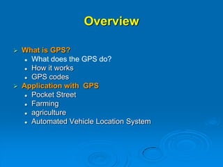
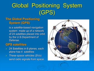
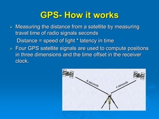
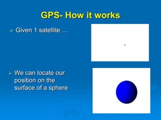
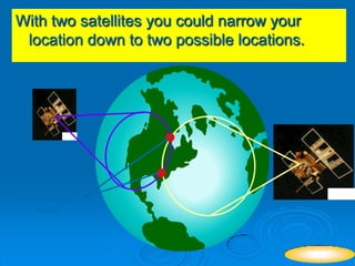
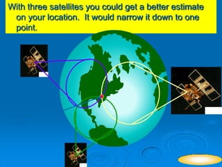
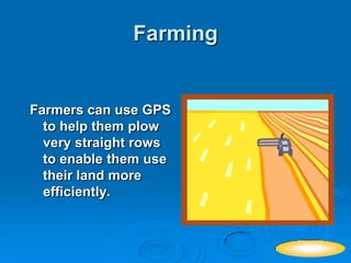
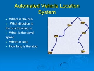
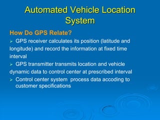
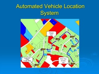
An Introduction GPS
Technology
PANKAJ AGARWAL
March 12, 2014
ICL GROUP OF COLLEGE
Overview
 What is GPS?
 What does the GPS do?
 How it works
 GPS codes
 Application with GPS
 Pocket Street
 Farming
 agriculture
 Automated Vehicle Location System
Global Positioning System
(GPS)
The Global Positioning
System (GPS)
is a satellite-based navigation
system made up of a network
of 24 satellites placed into orbit
by the U.S.Department of
Defense.
GPS satellites
 24 Satellites in 6 planes, each
plane has 4 satellites
 These space vehicles (SVs)
send radio signals from space.
What does the GPS do
 Satellite signals can be
processed in a GPS receiver.
 GPS receiver will show your
EXACT location on the Earth
(latitude and longitude)
 Helps you find your way to a
specified location
 Let’s you know what direction
you are heading and how fast
you are going
GPS- How it works
 Measuring the distance from a satellite by measuring
travel time of radio signals seconds
Distance = speed of light * latency in time
 Four GPS satellite signals are used to compute positions
in three dimensions and the time offset in the receiver
clock.
GPS- How it works
 Given 1 satellite …
 We can locate our
position on the
surface of a sphere
With two satellites you could narrow your
location down to two possible locations.
You Could Be
Here?
NEXT
With three satellites you could get a better estimate
on your location. It would narrow it down to one
point.
YOU ARE
HERE
NEXT
YOUR ARE
DEFFINATELY RIGHT
HERE
NEXT
for your location to be accurately measured. you have
at least four satellites.
“”
 The GPS receiver compares the time a signal was
transmitted by a satellite with the time it was received.
The time difference tells the GPS receiver how far away
the satellite is.
 With four or more satellites in view, the receiver can
determine the user's 3D position (latitude, longitude and
altitude).
When GPS receives a signal
 It compares that signal with all the known codes
(there are currently 37).
 The receiver determines which satellite it is.
 It decodes the timing information, multiplies by
the speed of light to find the radius of the
sphere.
 Once it has done that for 3 satellites, it can
determine the location.
How do GPS signals send all
this information?
 They use codes! Binary codes.
 Each satellite has a different code.
00001000101001110000111001001000100001000101011000111101110010101101100111101011
00101100101001100111111011001111001001100110100011100010010001011000101101110000
00110110010001000101101000101001000000011111000110001011111011111100110111001011
01111000111111010100101000010101001110000110100111011000111101111100001111111111
01001001001001100111010101111100001000101101001111110000100110111100111000110110
10110110101000010110100101000101001000111001110001010010111010111010101000001011
01110011011001101000000000001110111011000110110101010110110001110001100110011111
01011111001110101010000011111100100101000000111010001111011010010110110000010010
01001100001101100001111011101110001101110110100111001000110101010000110110100101
11001011111111101100011100000011011100011000000100000000100000110101000101011110
11000111011010001100101011111001111010000000110111100110011101011110000011110110
01000100101011100000000100001010101001111101100111011011111100101111000100110101
For example, here are the first 1000 numbers of the code
for satellite 1
10011110111010001001101111111110111100101101111011001101111101010100011111011000
11000100110011010000100000101111111000010000110101101011101011010011000001101000
01100010101011001000100100000110000011110000111010000011100100111011000000010110
01111000100101010111110101001111001011111011001010001011100001001110000111110111
01011101011011001111001001101011100100011011011111011001101011100001110101110001
10001111000001000111011011100010000011010011001001110000100010111000100100011011
11100011101010100110000000011001111001110101000010010001110010101010011100101101
11110011111110011010011101100111011001010010100110010101110111001110001101111001
10000010100011110011011110110011110100110111010011100110101010110100000101110001
11000111010110001111000100101001110101011000011000100011001010111001100001111100
00011111000100100011010001010001010010010001100001100100000110001100010100001101
10010110100110011000101101110011110010001010010100011110011101100001111101100101
This is the code for satellite 6
Strategy
 First we need to learn how GPS creates
these codes
 Then we need to come up with a way to
quickly tell the codes apart.
How do you create codes?
 You use binary addition rules.
 0+0=0
 1+0=1
 0+1=1
 1+1=10 (but only use the last bit, 0)
 GPS uses “shift registers.”
 The more shift registers you have, the more
complicated you can make your code.
Register1 Register2 Register3 Code
1 1 1 -
Start with all 1’s in your shift registers
Add Register 1 and Register 3
The answer 0 goes into Register 1 and
everything shifts to the right.
Here is an example with 3 shift registers
For this example, 1+1 =10 ==> 0
After 2N -1 steps (N is the number of
registers), the code repeats
Register1 Register2 Register3 Code
1 1 1 -
0 1 1 1
1 0 1 1
0 1 0 1
0 0 1 0
1 0 0 1
1 1 0 0
1 1 1 0
For 3 shift registers, the code repeats after 7 steps.
Real GPS
 Uses 10 shift registers.
 They add different registers to produce the
codes for different satellites.
 Satellite 1 uses 2 and 6.
 Satellite 2 uses 3 and 7, and so on.
 A 10-shift register code repeats after 210-1,
or 1023.
How do you compare codes?
100111101110100010011011111111101
000010001010011100001110010010001
Every time the numbers agree, add 1.
Every time the numbers disagree, subtract 1.
This example: 2 different satellites
100111101110100010011011111111111
000010001010011100001110010010001
14 agree
11 disagree
Total score: 3
Perfect agreement would be 35
Why are the codes shifted? The shift gives the
GPS receiver the time difference.
Time Difference (in seconds) * 2.99792458 108 meters/second =
Distance (in meters)
What is a typical Time Difference? GPS
satellites are ~20,000,000 meters above
the Earth.
20,000,000/300,000,000~ 70 milliseconds
Pocket Streets- an example with
GPS
 Pocket Streets offers exciting
features such as street-smart
mapping, map customization,
GPS and Microsoft Outlook
integration.
 With Pocket Streets on your
Pocket PC, you will take a smart
map with you wherever you go.
Pocket Streets- an example with
GPS
 Download the map for the city.
 Connect the GPS receiver to
Pocket PC.
 Choose "Track Position" from the
GPS menu to show your current
position on the map.
 The position moves when you move.
Farming
Farmers can use GPS
to help them plow
very straight rows
to enable them use
their land more
efficiently.
NEXT
Agriculture
Farmers can use GPS to help
mark areas for pesticide or
fertilizer application. Thus
reducing waste.
NEXT
Automated Vehicle Location
System
 Where is the bus
 What direction is
the bus traveling to
 What is the travel
speed
 Where is stop
 How long is the stop
Automated Vehicle Location
System
How Do GPS Relate?
 GPS receiver calculates its position (latitude and
longitude) and record the information at fixed time
interval
 GPS transmitter transmits location and vehicle
dynamic data to control center at prescribed interval
 Control center system process data accoding to
customer specifications
Automated Vehicle Location
System
Applications – Military
 Military GPS user equipment has been
integrated into fighters, bombers, tankers,
helicopters, ships, submarines, tanks,
jeeps, and soldiers' equipment.
 To prevent GPS interception by the
enemy, the government controls GPS
receiver exports
Another GPS application?
 Besides being used by the military, GPS is
used in forestry, biology, fishing, hunting,
boating, racing, nursing, and many other
fields.
 GPS technology can be effectively used in
your classroom as well.
Conclusions
 GPS can show your EXACT location on the Earth
(latitude and longitude)
**
THANKS

BEST concept on Global positioning system(GPS)