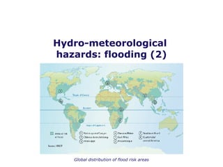
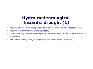
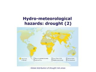
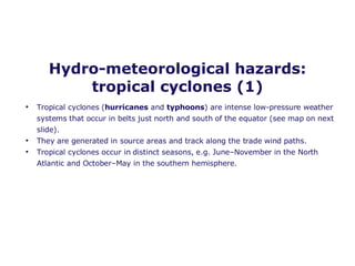
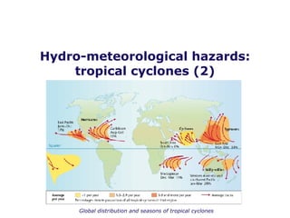
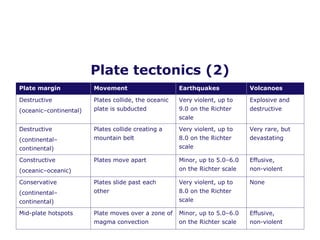
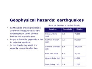
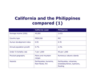
World at risk Global hazard patterns
Hazards in the UK On 27 February 2008 an  earthquake  of 5.2 on the Richter scale hit Market Rasen in Lincolnshire. Little damage was done, but the event illustrates that hazards are an ever-present threat.  Grimsby and Doncaster were both  flooded  on 27 June 2007 during the ‘summer of floods’. The Yorkshire Water area suffered a severe  drought  in 1995. High temperatures and low rainfall led to reservoir levels falling to 25% of capacity by August. Water was transported into the Yorkshire Water area by road tanker to increase supply, but at a cost of $47 million.
Researching your own area Old maps, photos and newspaper articles can indicate the ‘hazard history’ of your locality.  Environment Agency flood maps reveal the risk of river and coastal flooding. The UK Climate Impacts Programme has regional climate change assessments which allow future risk trends to be assessed.
Hydro-meteorological  hazards: flooding (1) Flooding is a common hazard, both at the coast and along rivers. Risk is related to both  physical   factors  (e.g. heavy rain, impermeable rock/soil, sparse vegetation cover, steep slopes) and  human factors  (e.g. urbanisation, deforestation, poor river management, building on floodplains, lack of preparedness).  Flooding is possible in numerous locations (see map on next slide) and is likely to increase in frequency in many areas due to climate change.
Hydro-meteorological  hazards: flooding (2) Global distribution of flood risk areas
Hydro-meteorological  hazards: drought (1) Drought occurs when precipitation falls below ‘normal’ and expected levels. Drought is a slow-onset, creeping hazard. Those who rely directly on food production and natural water sources are most vulnerable. In extreme cases, drought may contribute to the onset of famine.
Hydro-meteorological  hazards: drought (2) Global distribution of drought risk areas
Hydro-meteorological hazards: tropical cyclones (1) Tropical cyclones ( hurricanes  and  typhoons ) are intense low-pressure weather systems that occur in belts just north and south of the equator (see map on next slide). They are generated in source areas and track along the trade wind paths.  Tropical cyclones occur in distinct seasons, e.g. June–November in the North Atlantic and October–May in the southern hemisphere.
Hydro-meteorological hazards: tropical cyclones (2) Global distribution and seasons of tropical cyclones
Hydro-meteorological hazards: hurricanes Hurricane intensity is measured on the  Saffir-Simpson scale  which ranges from 1 to 5, with 5 the most devastating storm. Storms that make landfall have severe impacts: low pressure creates a  storm surge , flooding low-lying coastal areas intense rainfall  contributes to flooding winds  of up to 280 km h –1  cause structural damage and often many deaths
Plate tectonics (1) The movement of the Earth’s tectonic plates is responsible for most  earthquakes  and  volcanoes .  Oceanic plates are normally thicker and more dense than continental plates.  Most hazards occur at the boundaries where two plates meet. The risk from these hazards is closely related to the type of plate boundary, with some boundaries more hazardous than others.
Plate tectonics (2) Plate margin Movement  Earthquakes Volcanoes Destructive  (oceanic–continental) Plates collide, the oceanic plate is subducted  Very violent, up to 9.0 on the Richter scale Explosive and destructive Destructive  (continental– continental) Plates collide creating a mountain belt Very violent, up to 8.0 on the Richter scale Very rare, but devastating Constructive (oceanic–oceanic) Plates move apart Minor, up to 5.0–6.0 on the Richter scale Effusive,  non-violent Conservative  (continental– continental) Plates slide past each other Very violent, up to 8.0 on the Richter scale None Mid-plate hotspots  Plate moves over a zone of magma convection Minor, up to 5.0–6.0 on the Richter scale Effusive,  non-violent
Geophysical hazards: volcanoes Volcanoes occur in well-known, localised areas. Monitoring and prediction can often reduce risk. The most devastating volcanoes are located on destructive plate boundaries in densely populated developing countries.  A single volcano can generate a range of hazards, including lava flows, ash fall, pyroclastic flows and lahars, often occurring simultaneously.
Geophysical hazards: earthquakes Earthquakes are not predictable, and their consequences can be catastrophic in terms of both human and economic loss. Large, vulnerable  populations live in high-risk locations.  In the developing world, the capacity to cope is often low. Worst earthquakes in the last decade Location Magnitude Deaths  Sichuan, China 2008 7.8 70,000 Kashmir, Pakistan  2005 7.6 80,000+ Sumatra, Indonesia 2004 8.9 200,000+ Bam, Iran  2003 6.6  26,000 Gujarat, India 2001 8.1  20,000 Izmit,Turkey 1999 7.4 17,000
Slides Landslides  and  avalanches  are two types of mass movement. Landslides are most common in geologically young mountains and tectonically active areas. Water movement and precipitation, plus land-use change (e.g. deforestation), are important factors in generating landslides. Avalanches are most common in Alpine environments where winter snowfall is disturbed by periodic thaws, wind, further snowfall and alpine sports.  Landslides may be triggered by earthquakes, for example up to a third of deaths in the 2005 Kashmir earthquake were a result of landslides.
Disaster hotspots Disaster hotspots occur when two or more hazards occur in the same location. In many cases, one hazard triggers or exacerbates another — earthquakes trigger landslides, and typhoon rainfall triggers lahars. Disaster hotspots are the world’s most unpredictable and dangerous locations. The  Philippines  and the  California coast  are compulsory case studies for this specification.
California and the Philippines compared (1) Earthquakes, volcanoes, landslides/lahars, typhoons, flooding Earthquakes, tsunamis, flash floods, fire Hazards Numerous volcanic islands Plains and mountain ranges Physical geography 40 per 1,000 7 per 1,000 Under 5 mortality rate 2.3% 0.7% Annual population growth 0.78 0.95 Human development index RIC MEDC/G8 Country type 1,415 45,000 Average income (US$) Philippines California coast
California and the Philippines compared (2) The two hotspots contrast in terms of physical geography.  The Philippines sit on a destructive plate margin, where the Eurasian plate and the Philippines plate collide (explosive volcanic activity and frequent earthquakes). California sits on a conservative plate boundary (earthquakes).

Global Hazards Patterns

  • 1.
    World at riskGlobal hazard patterns
  • 2.
    Hazards in theUK On 27 February 2008 an earthquake of 5.2 on the Richter scale hit Market Rasen in Lincolnshire. Little damage was done, but the event illustrates that hazards are an ever-present threat. Grimsby and Doncaster were both flooded on 27 June 2007 during the ‘summer of floods’. The Yorkshire Water area suffered a severe drought in 1995. High temperatures and low rainfall led to reservoir levels falling to 25% of capacity by August. Water was transported into the Yorkshire Water area by road tanker to increase supply, but at a cost of $47 million.
  • 3.
    Researching your ownarea Old maps, photos and newspaper articles can indicate the ‘hazard history’ of your locality. Environment Agency flood maps reveal the risk of river and coastal flooding. The UK Climate Impacts Programme has regional climate change assessments which allow future risk trends to be assessed.
  • 4.
    Hydro-meteorological hazards:flooding (1) Flooding is a common hazard, both at the coast and along rivers. Risk is related to both physical factors (e.g. heavy rain, impermeable rock/soil, sparse vegetation cover, steep slopes) and human factors (e.g. urbanisation, deforestation, poor river management, building on floodplains, lack of preparedness). Flooding is possible in numerous locations (see map on next slide) and is likely to increase in frequency in many areas due to climate change.
  • 5.
    Hydro-meteorological hazards:flooding (2) Global distribution of flood risk areas
  • 6.
    Hydro-meteorological hazards:drought (1) Drought occurs when precipitation falls below ‘normal’ and expected levels. Drought is a slow-onset, creeping hazard. Those who rely directly on food production and natural water sources are most vulnerable. In extreme cases, drought may contribute to the onset of famine.
  • 7.
    Hydro-meteorological hazards:drought (2) Global distribution of drought risk areas
  • 8.
    Hydro-meteorological hazards: tropicalcyclones (1) Tropical cyclones ( hurricanes and typhoons ) are intense low-pressure weather systems that occur in belts just north and south of the equator (see map on next slide). They are generated in source areas and track along the trade wind paths. Tropical cyclones occur in distinct seasons, e.g. June–November in the North Atlantic and October–May in the southern hemisphere.
  • 9.
    Hydro-meteorological hazards: tropicalcyclones (2) Global distribution and seasons of tropical cyclones
  • 10.
    Hydro-meteorological hazards: hurricanesHurricane intensity is measured on the Saffir-Simpson scale which ranges from 1 to 5, with 5 the most devastating storm. Storms that make landfall have severe impacts: low pressure creates a storm surge , flooding low-lying coastal areas intense rainfall contributes to flooding winds of up to 280 km h –1 cause structural damage and often many deaths
  • 11.
    Plate tectonics (1)The movement of the Earth’s tectonic plates is responsible for most earthquakes and volcanoes . Oceanic plates are normally thicker and more dense than continental plates. Most hazards occur at the boundaries where two plates meet. The risk from these hazards is closely related to the type of plate boundary, with some boundaries more hazardous than others.
  • 12.
    Plate tectonics (2)Plate margin Movement Earthquakes Volcanoes Destructive (oceanic–continental) Plates collide, the oceanic plate is subducted Very violent, up to 9.0 on the Richter scale Explosive and destructive Destructive (continental– continental) Plates collide creating a mountain belt Very violent, up to 8.0 on the Richter scale Very rare, but devastating Constructive (oceanic–oceanic) Plates move apart Minor, up to 5.0–6.0 on the Richter scale Effusive, non-violent Conservative (continental– continental) Plates slide past each other Very violent, up to 8.0 on the Richter scale None Mid-plate hotspots Plate moves over a zone of magma convection Minor, up to 5.0–6.0 on the Richter scale Effusive, non-violent
  • 13.
    Geophysical hazards: volcanoesVolcanoes occur in well-known, localised areas. Monitoring and prediction can often reduce risk. The most devastating volcanoes are located on destructive plate boundaries in densely populated developing countries. A single volcano can generate a range of hazards, including lava flows, ash fall, pyroclastic flows and lahars, often occurring simultaneously.
  • 14.
    Geophysical hazards: earthquakesEarthquakes are not predictable, and their consequences can be catastrophic in terms of both human and economic loss. Large, vulnerable populations live in high-risk locations. In the developing world, the capacity to cope is often low. Worst earthquakes in the last decade Location Magnitude Deaths Sichuan, China 2008 7.8 70,000 Kashmir, Pakistan 2005 7.6 80,000+ Sumatra, Indonesia 2004 8.9 200,000+ Bam, Iran 2003 6.6 26,000 Gujarat, India 2001 8.1 20,000 Izmit,Turkey 1999 7.4 17,000
  • 15.
    Slides Landslides and avalanches are two types of mass movement. Landslides are most common in geologically young mountains and tectonically active areas. Water movement and precipitation, plus land-use change (e.g. deforestation), are important factors in generating landslides. Avalanches are most common in Alpine environments where winter snowfall is disturbed by periodic thaws, wind, further snowfall and alpine sports. Landslides may be triggered by earthquakes, for example up to a third of deaths in the 2005 Kashmir earthquake were a result of landslides.
  • 16.
    Disaster hotspots Disasterhotspots occur when two or more hazards occur in the same location. In many cases, one hazard triggers or exacerbates another — earthquakes trigger landslides, and typhoon rainfall triggers lahars. Disaster hotspots are the world’s most unpredictable and dangerous locations. The Philippines and the California coast are compulsory case studies for this specification.
  • 17.
    California and thePhilippines compared (1) Earthquakes, volcanoes, landslides/lahars, typhoons, flooding Earthquakes, tsunamis, flash floods, fire Hazards Numerous volcanic islands Plains and mountain ranges Physical geography 40 per 1,000 7 per 1,000 Under 5 mortality rate 2.3% 0.7% Annual population growth 0.78 0.95 Human development index RIC MEDC/G8 Country type 1,415 45,000 Average income (US$) Philippines California coast
  • 18.
    California and thePhilippines compared (2) The two hotspots contrast in terms of physical geography. The Philippines sit on a destructive plate margin, where the Eurasian plate and the Philippines plate collide (explosive volcanic activity and frequent earthquakes). California sits on a conservative plate boundary (earthquakes).