SlideShare a Scribd company logo
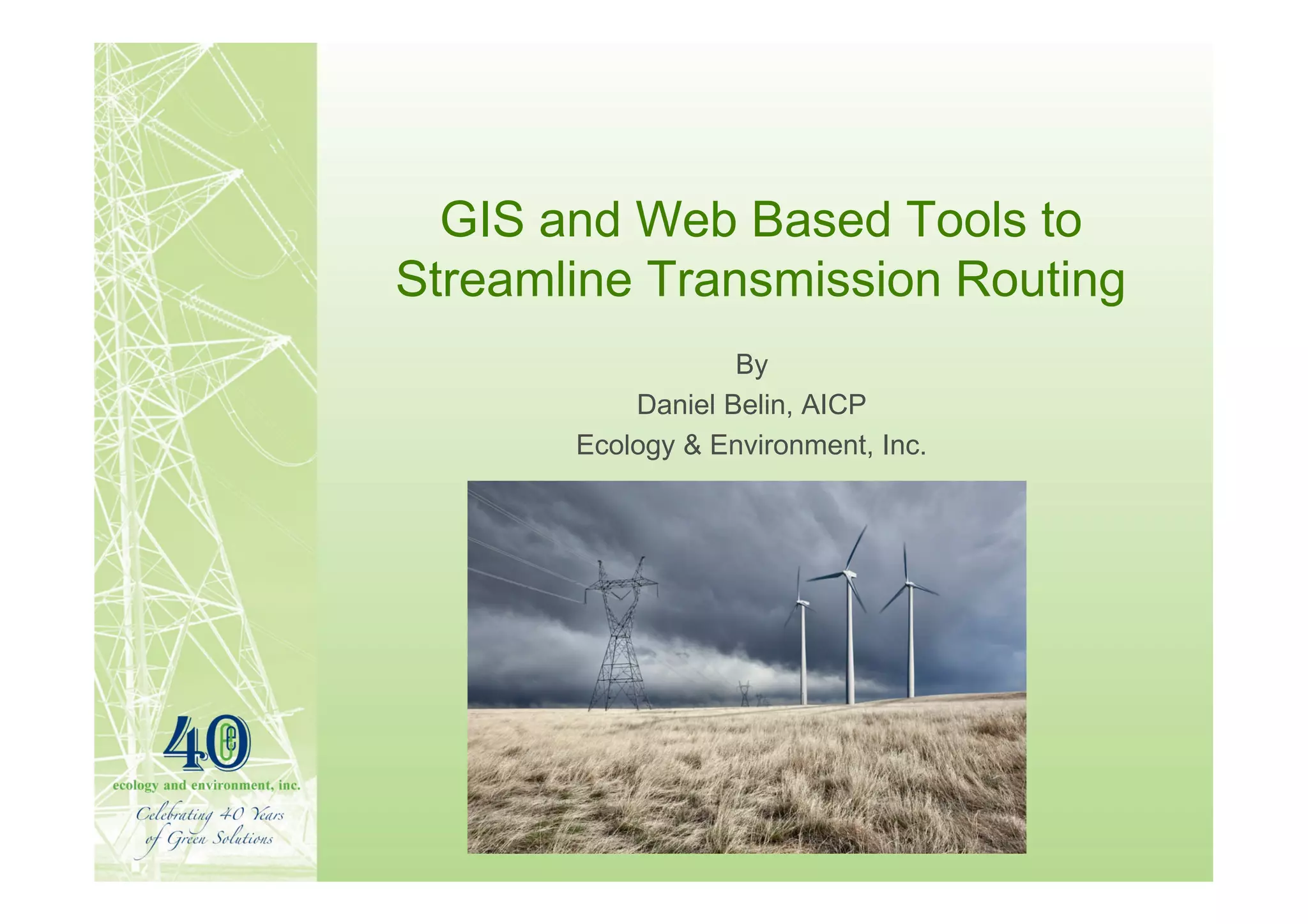
GIS and Web Based Tools to
Streamline Transmission Routing
                   By
           Daniel Belin, AICP
       Ecology & Environment, Inc.
Presentation Topics
• Background
• Corridor Routing Opportunities and
  Challenges
• Benefits of web based GIS Tools for
  Transmission Line Routing
Background
• Resource Planning vs. Transmission
  Routing
• WECC / WGA initiatives
• HVDC emergence
Background
• Resource Planning
  – Reliability modeling (congestion)
  – Corridor separation
  – Load growth scenarios – time horizon
• Transmission Routing
  – Natural resource planning (integrity)
  – Corridor co-location
  – Impact scenarios – time horizon
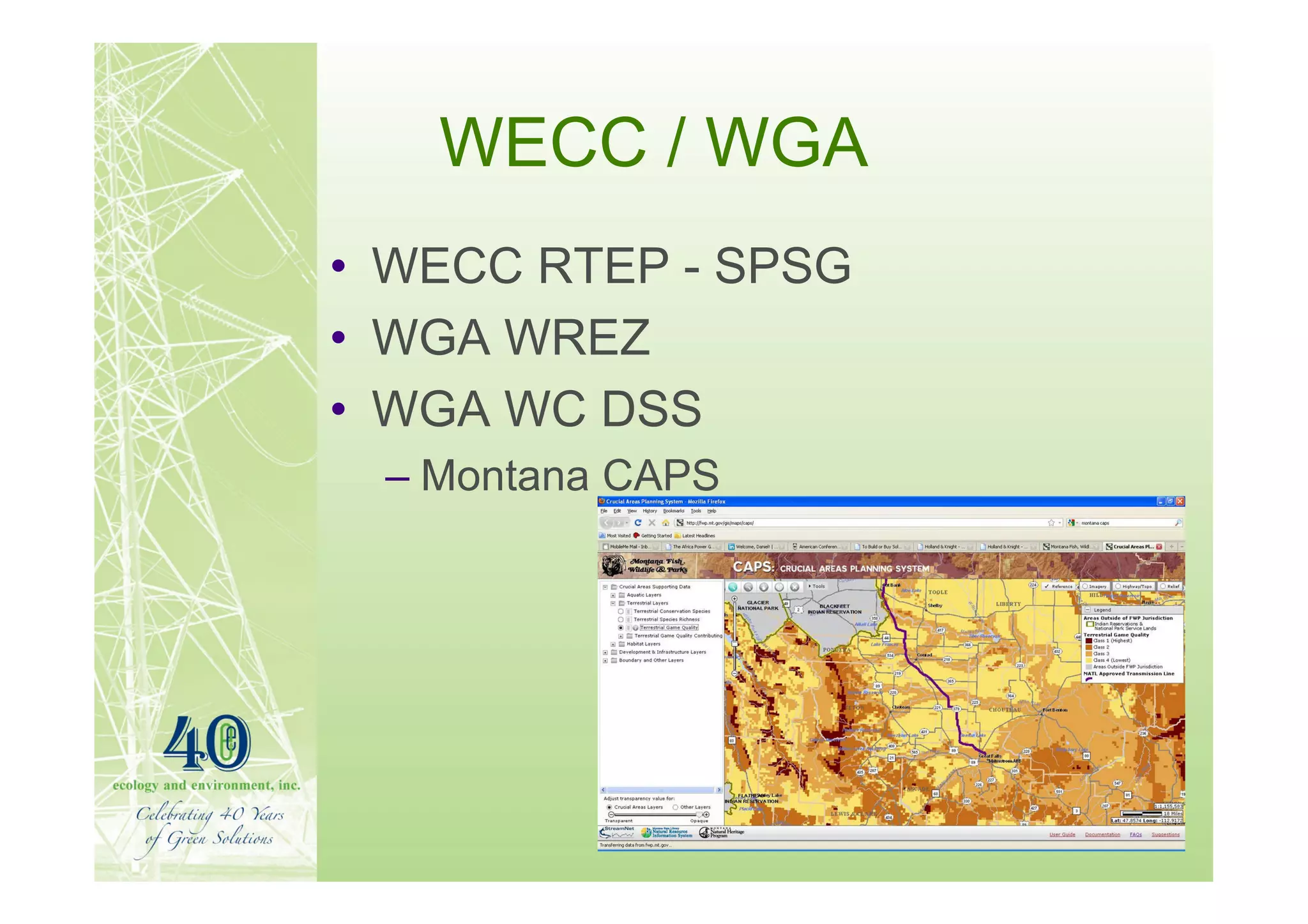
WECC / WGA
• WECC RTEP - SPSG
• WGA WREZ
• WGA WC DSS
 – Montana CAPS
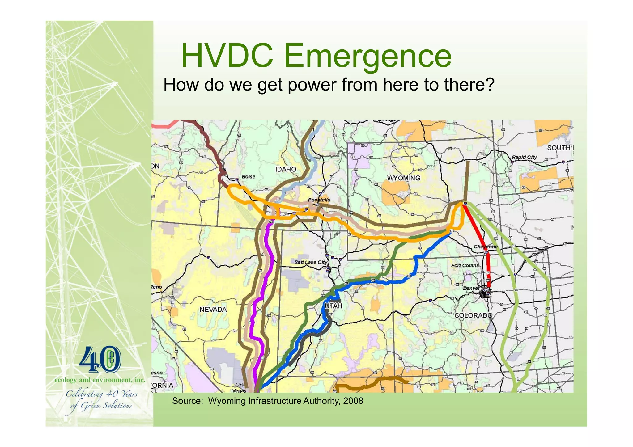
HVDC Emergence
How do we get power from here to there?


 Source: Wyoming Infrastructure Authority, 2008
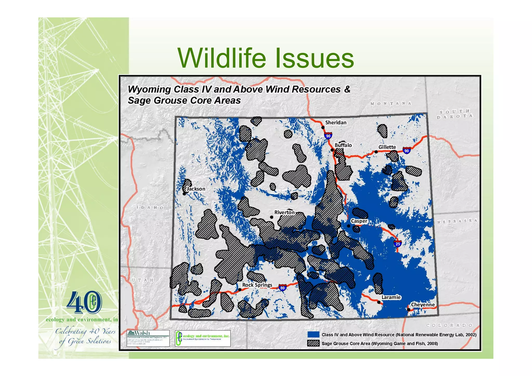
Wildlife Issues
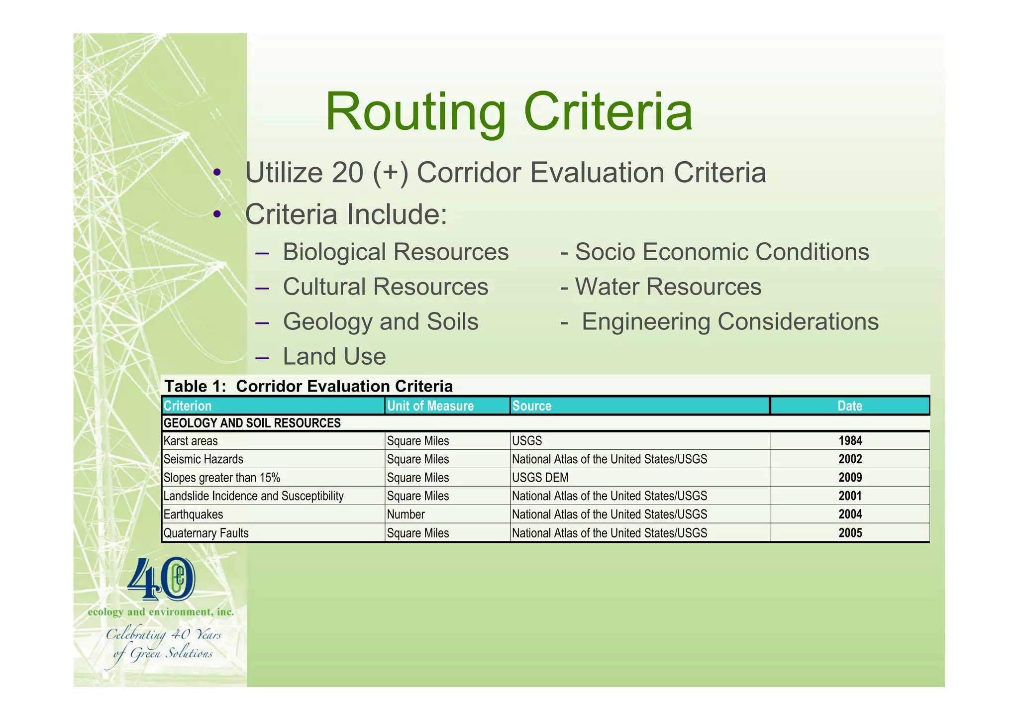
Routing Criteria
            • Utilize 20 (+) Corridor Evaluation Criteria
            • Criteria Include:
                   –     Biological Resources                       - Socio Economic Conditions
                   –     Cultural Resources                         - Water Resources
                   –     Geology and Soils                          - Engineering Considerations
                   –     Land Use
Table 1: Corridor Evaluation Criteria
Criterion                                Unit of Measure   Source                                     Date
GEOLOGY AND SOIL RESOURCES
Karst areas                              Square Miles      USGS                                       1984
Seismic Hazards                          Square Miles      National Atlas of the United States/USGS   2002
Slopes greater than 15%                  Square Miles      USGS DEM                                   2009
Landslide Incidence and Susceptibility   Square Miles      National Atlas of the United States/USGS   2001
Earthquakes                              Number            National Atlas of the United States/USGS   2004
Quaternary Faults                        Square Miles      National Atlas of the United States/USGS   2005
Routing Opportunities
Parallel Existing Infrastructure / ROW
• Transmission Line ROW
• Pipelines
• Interstate Highways and State Routes
• Railroads
• Previously disturbed corridors
Non-Parallel Routing
• Utilize Undeveloped Corridors, as needed
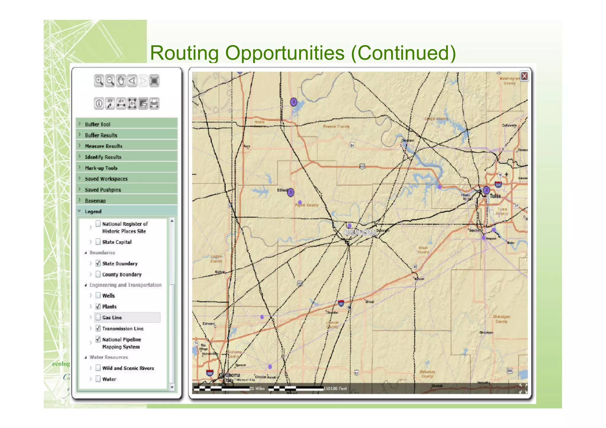
Routing Opportunities (Continued)
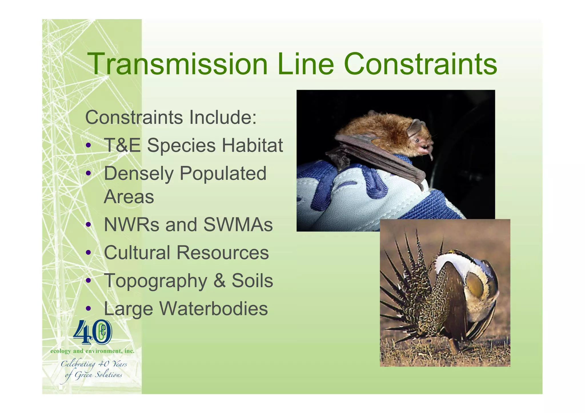
Transmission Line Constraints
Constraints Include:
• T&E Species Habitat
• Densely Populated
  Areas
• NWRs and SWMAs
• Cultural Resources
• Topography & Soils
• Large Waterbodies
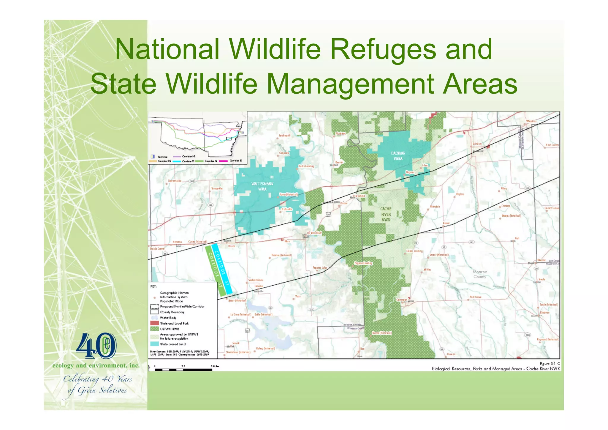
National Wildlife Refuges and
State Wildlife Management Areas
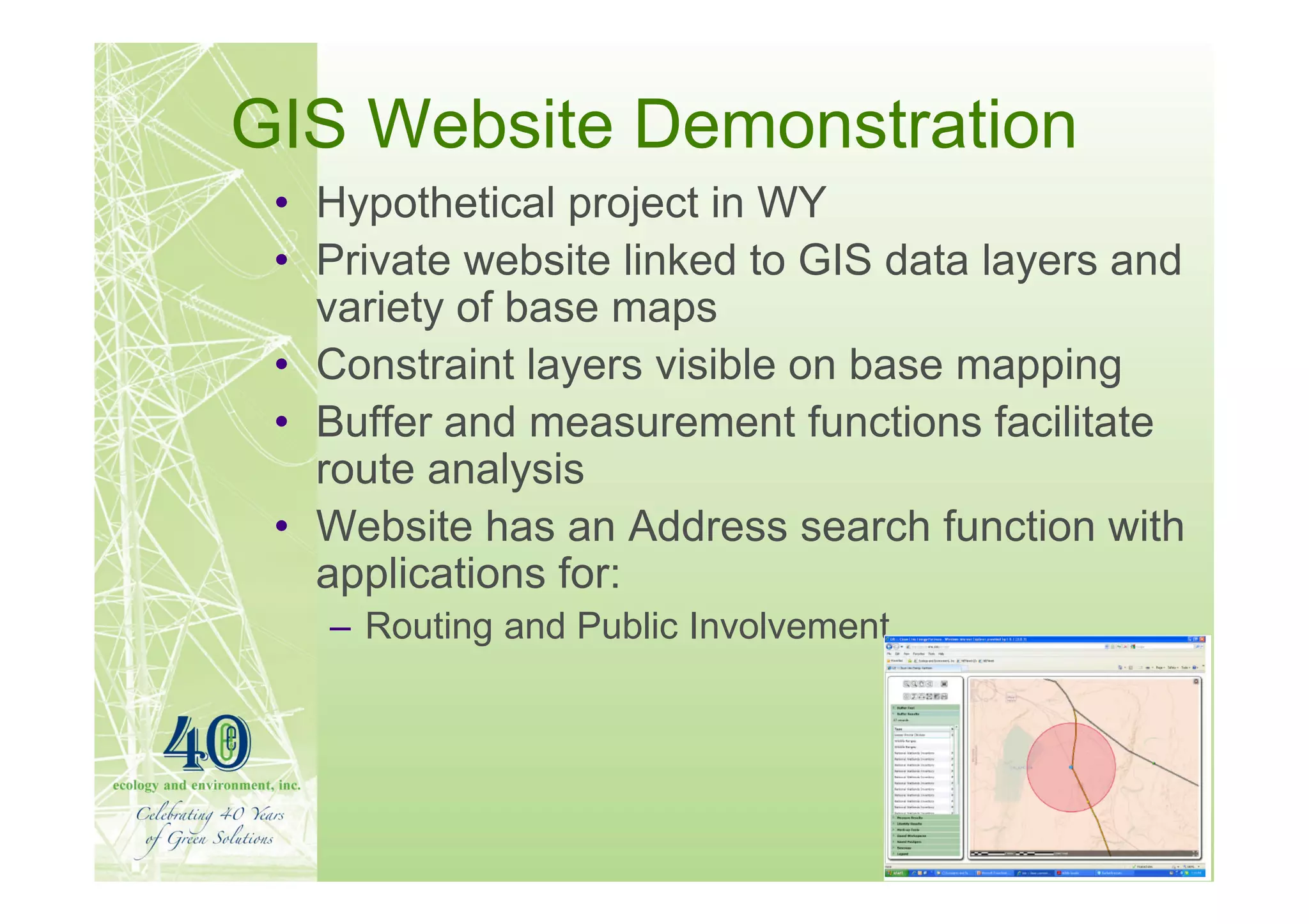
GIS Website Demonstration
 • Hypothetical project in WY
 • Private website linked to GIS data layers and
   variety of base maps
 • Constraint layers visible on base mapping
 • Buffer and measurement functions facilitate
   route analysis
 • Website has an Address search function with
   applications for:
   – Routing and Public Involvement
GIS Website Case Study
     (Continued)


   Corridor Routing Tool
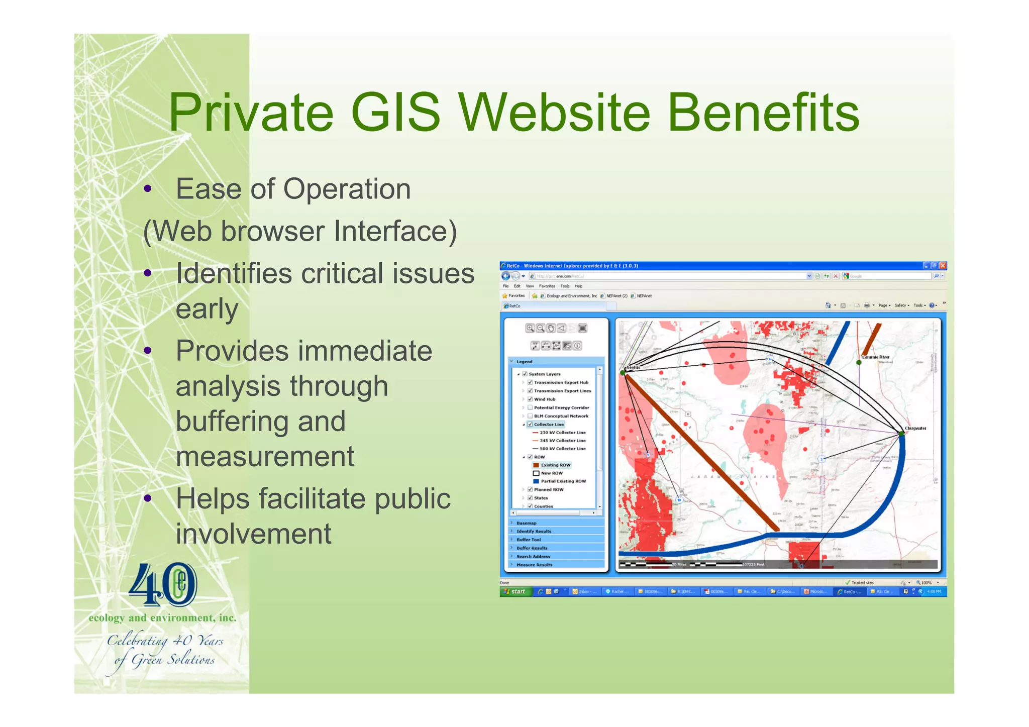
Private GIS Website Benefits
• Ease of Operation
(Web browser Interface)
• Identifies critical issues
  early
• Provides immediate
  analysis through
  buffering and
  measurement
• Helps facilitate public
  involvement
Conclusion
• New paradigm in transmission planning in the US
• Many more factors and stakeholders
• Web based GIS sites expedite routing study tasks
   – Provide critical information early
   – Keep project team coordinated
   – Identify stakeholders quicker
   – Consult with agencies sooner
   – Eliminate costly alternatives proactively
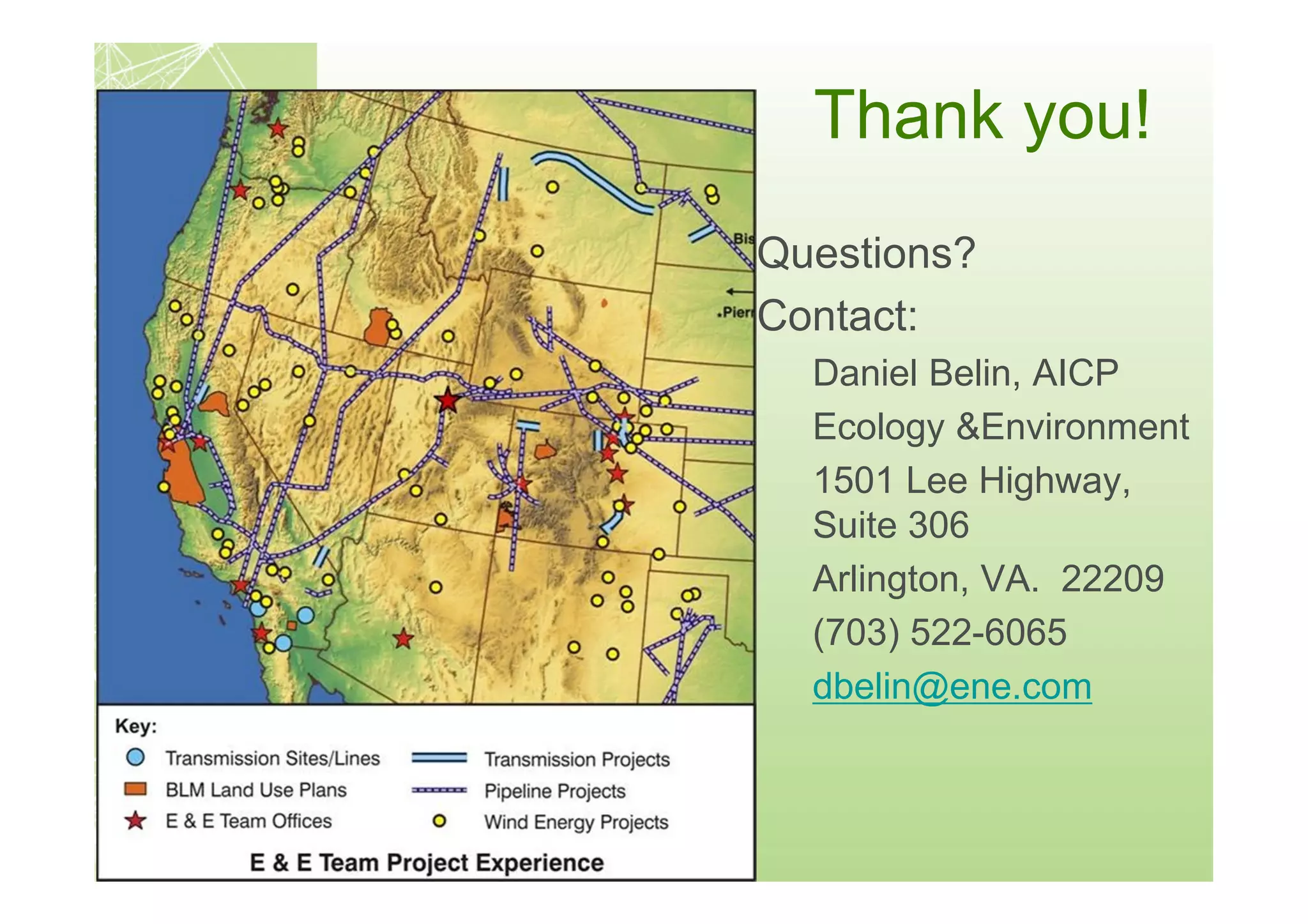
Thank you!
Questions?
Contact:
  Daniel Belin, AICP
  Ecology &Environment
  1501 Lee Highway,
  Suite 306
  Arlington, VA. 22209
  (703) 522-6065
  dbelin@ene.com

More Related Content

What's hot

Watershed delineation and LULC mapping
Watershed delineation and LULC mappingWatershed delineation and LULC mapping
Watershed delineation and LULC mapping
Kapil Thakur
 
Spatial Database Systems
Spatial Database SystemsSpatial Database Systems
Spatial Database Systems
Asifuzzaman Hridoy
 
Hardware and software requirements for gis
Hardware and software requirements for gisHardware and software requirements for gis
Hardware and software requirements for gis
Sumant Diwakar
 
Application of GIS (Geographical information system)
Application of GIS (Geographical information system)Application of GIS (Geographical information system)
Application of GIS (Geographical information system)
Fayaz Ahamed A P
 
Web GIS using Google Map and QGIS
Web GIS using Google Map and QGISWeb GIS using Google Map and QGIS
Web GIS using Google Map and QGIS
IndranilChakraborty42
 
Application of gis in urban planning
Application of gis in urban planningApplication of gis in urban planning
Application of gis in urban planning
WESLEY MELI
 
Vector data model
Vector data model Vector data model
Vector data model
Pramoda Raj
 
Digital Cartography
Digital CartographyDigital Cartography
Digital Cartography
Patrick Woessner
 
TYBSC IT PGIS Unit I Chapter I- Introduction to Geographic Information Systems
TYBSC IT PGIS Unit I  Chapter I- Introduction to Geographic Information SystemsTYBSC IT PGIS Unit I  Chapter I- Introduction to Geographic Information Systems
TYBSC IT PGIS Unit I Chapter I- Introduction to Geographic Information Systems
Arti Parab Academics
 
River Discharge and Hydrographs
River Discharge and HydrographsRiver Discharge and Hydrographs
River Discharge and Hydrographs
Steven Heath
 
Flood modelling and prediction 1
Flood modelling and prediction 1Flood modelling and prediction 1
Flood modelling and prediction 1
tp jayamohan
 
Theoretical framework for gis
Theoretical framework for gisTheoretical framework for gis
Theoretical framework for gis
srinivas2036
 
Introduction to GIS
Introduction to GISIntroduction to GIS
Introduction to GIS
Uday kumar Devalla
 
Morphometric Analysis and prioritization of watersheds of Mahanadi River Basi...
Morphometric Analysis and prioritization of watersheds of Mahanadi River Basi...Morphometric Analysis and prioritization of watersheds of Mahanadi River Basi...
Morphometric Analysis and prioritization of watersheds of Mahanadi River Basi...
RINKU MEENA
 
WEB GIS AND WEB MAP.pptx
WEB GIS AND WEB MAP.pptxWEB GIS AND WEB MAP.pptx
WEB GIS AND WEB MAP.pptx
Asim Pt
 
Remote Sensing: Overlay Analysis
Remote Sensing: Overlay AnalysisRemote Sensing: Overlay Analysis
Remote Sensing: Overlay Analysis
Kamlesh Kumar
 
Introduction to Groundwater Modelling
Introduction to Groundwater ModellingIntroduction to Groundwater Modelling
Introduction to Groundwater Modelling
C. P. Kumar
 
Introduction to gis and its application
Introduction to gis and its application Introduction to gis and its application
Introduction to gis and its application
gandhinagar
 
TYBSC IT PGIS Unit I Chapter II Geographic Information and Spacial Database
TYBSC IT PGIS Unit I Chapter II Geographic Information and Spacial DatabaseTYBSC IT PGIS Unit I Chapter II Geographic Information and Spacial Database
TYBSC IT PGIS Unit I Chapter II Geographic Information and Spacial Database
Arti Parab Academics
 
Methods of route assignment
Methods of route assignmentMethods of route assignment
Methods of route assignment
Kathan Sindhvad
 

What's hot (20)

Watershed delineation and LULC mapping
Watershed delineation and LULC mappingWatershed delineation and LULC mapping
Watershed delineation and LULC mapping
 
Spatial Database Systems
Spatial Database SystemsSpatial Database Systems
Spatial Database Systems
 
Hardware and software requirements for gis
Hardware and software requirements for gisHardware and software requirements for gis
Hardware and software requirements for gis
 
Application of GIS (Geographical information system)
Application of GIS (Geographical information system)Application of GIS (Geographical information system)
Application of GIS (Geographical information system)
 
Web GIS using Google Map and QGIS
Web GIS using Google Map and QGISWeb GIS using Google Map and QGIS
Web GIS using Google Map and QGIS
 
Application of gis in urban planning
Application of gis in urban planningApplication of gis in urban planning
Application of gis in urban planning
 
Vector data model
Vector data model Vector data model
Vector data model
 
Digital Cartography
Digital CartographyDigital Cartography
Digital Cartography
 
TYBSC IT PGIS Unit I Chapter I- Introduction to Geographic Information Systems
TYBSC IT PGIS Unit I  Chapter I- Introduction to Geographic Information SystemsTYBSC IT PGIS Unit I  Chapter I- Introduction to Geographic Information Systems
TYBSC IT PGIS Unit I Chapter I- Introduction to Geographic Information Systems
 
River Discharge and Hydrographs
River Discharge and HydrographsRiver Discharge and Hydrographs
River Discharge and Hydrographs
 
Flood modelling and prediction 1
Flood modelling and prediction 1Flood modelling and prediction 1
Flood modelling and prediction 1
 
Theoretical framework for gis
Theoretical framework for gisTheoretical framework for gis
Theoretical framework for gis
 
Introduction to GIS
Introduction to GISIntroduction to GIS
Introduction to GIS
 
Morphometric Analysis and prioritization of watersheds of Mahanadi River Basi...
Morphometric Analysis and prioritization of watersheds of Mahanadi River Basi...Morphometric Analysis and prioritization of watersheds of Mahanadi River Basi...
Morphometric Analysis and prioritization of watersheds of Mahanadi River Basi...
 
WEB GIS AND WEB MAP.pptx
WEB GIS AND WEB MAP.pptxWEB GIS AND WEB MAP.pptx
WEB GIS AND WEB MAP.pptx
 
Remote Sensing: Overlay Analysis
Remote Sensing: Overlay AnalysisRemote Sensing: Overlay Analysis
Remote Sensing: Overlay Analysis
 
Introduction to Groundwater Modelling
Introduction to Groundwater ModellingIntroduction to Groundwater Modelling
Introduction to Groundwater Modelling
 
Introduction to gis and its application
Introduction to gis and its application Introduction to gis and its application
Introduction to gis and its application
 
TYBSC IT PGIS Unit I Chapter II Geographic Information and Spacial Database
TYBSC IT PGIS Unit I Chapter II Geographic Information and Spacial DatabaseTYBSC IT PGIS Unit I Chapter II Geographic Information and Spacial Database
TYBSC IT PGIS Unit I Chapter II Geographic Information and Spacial Database
 
Methods of route assignment
Methods of route assignmentMethods of route assignment
Methods of route assignment
 

Viewers also liked

TerraWorld
TerraWorldTerraWorld
Julie Rediker GIS Professional
Julie Rediker GIS ProfessionalJulie Rediker GIS Professional
Julie Rediker GIS Professional
Julie Rediker
 
Problems in overhead transmission line
Problems in overhead transmission lineProblems in overhead transmission line
Problems in overhead transmission line
Dr. Bibhu Prasad Ganthia
 
Electrical transmission line
Electrical transmission lineElectrical transmission line
Electrical transmission line
Dhananjay Jha
 
Sistem Persekutuan di Malaysia
Sistem Persekutuan di MalaysiaSistem Persekutuan di Malaysia
Sistem Persekutuan di MalaysiaFaizol Haffiz
 
CV imran-Asghar
CV imran-AsgharCV imran-Asghar
CV imran-Asghar
Imran Asghar
 
AMCO Electrical and Engineering Co, Kolkata
AMCO Electrical and Engineering Co, Kolkata AMCO Electrical and Engineering Co, Kolkata
AMCO Electrical and Engineering Co, Kolkata
amcoelectricals
 
SUBSTATION OVERVIEW - A presentation on substation
SUBSTATION OVERVIEW - A presentation on substationSUBSTATION OVERVIEW - A presentation on substation
SUBSTATION OVERVIEW - A presentation on substation
raiamitesh8
 
Joint Informi GIS / IBM presentation at Esri UC 2014
Joint Informi GIS / IBM presentation at Esri UC 2014Joint Informi GIS / IBM presentation at Esri UC 2014
Joint Informi GIS / IBM presentation at Esri UC 2014
Jens Dalsgaard
 
Power in visayas
Power in visayasPower in visayas
Power in visayas
Mark Frencer Lozada
 
Future Inspection of Overhead Transmission Lines
 Future Inspection of Overhead Transmission Lines Future Inspection of Overhead Transmission Lines
Future Inspection of Overhead Transmission Lines
Corporación Eléctrica del Ecuador, CELEC EP
 
KPTL - OUR CSR ACTIVITIES
KPTL -  OUR CSR ACTIVITIESKPTL -  OUR CSR ACTIVITIES
KPTL - OUR CSR ACTIVITIES
AYODHYADAS MANIKPURI
 
Surge impedance sil
Surge impedance silSurge impedance sil
Surge impedance sil
h-nouri
 
TechM GIS Telecom
TechM GIS TelecomTechM GIS Telecom
TechM GIS Telecom
TechM-GIS
 
GIS Telecom ROI
GIS Telecom ROIGIS Telecom ROI
GIS Telecom ROI
ktrowbri
 
Representation of short & medium transmission lines
Representation of short & medium transmission linesRepresentation of short & medium transmission lines
Representation of short & medium transmission lines
vishalgohel12195
 
Intelligent power transmission asset management solutions
Intelligent power transmission asset management solutionsIntelligent power transmission asset management solutions
Intelligent power transmission asset management solutions
Ravindranatha Reddy Bandi
 
Gis for-telecomm
Gis for-telecommGis for-telecomm
Gis for-telecomm
Esri
 
FINAL 31,12,10
FINAL 31,12,10FINAL 31,12,10
FINAL 31,12,10
Khurram Butt
 
Transformer asset management
Transformer asset managementTransformer asset management
Transformer asset management
Muthar Hussain
 

Viewers also liked (20)

TerraWorld
TerraWorldTerraWorld
TerraWorld
 
Julie Rediker GIS Professional
Julie Rediker GIS ProfessionalJulie Rediker GIS Professional
Julie Rediker GIS Professional
 
Problems in overhead transmission line
Problems in overhead transmission lineProblems in overhead transmission line
Problems in overhead transmission line
 
Electrical transmission line
Electrical transmission lineElectrical transmission line
Electrical transmission line
 
Sistem Persekutuan di Malaysia
Sistem Persekutuan di MalaysiaSistem Persekutuan di Malaysia
Sistem Persekutuan di Malaysia
 
CV imran-Asghar
CV imran-AsgharCV imran-Asghar
CV imran-Asghar
 
AMCO Electrical and Engineering Co, Kolkata
AMCO Electrical and Engineering Co, Kolkata AMCO Electrical and Engineering Co, Kolkata
AMCO Electrical and Engineering Co, Kolkata
 
SUBSTATION OVERVIEW - A presentation on substation
SUBSTATION OVERVIEW - A presentation on substationSUBSTATION OVERVIEW - A presentation on substation
SUBSTATION OVERVIEW - A presentation on substation
 
Joint Informi GIS / IBM presentation at Esri UC 2014
Joint Informi GIS / IBM presentation at Esri UC 2014Joint Informi GIS / IBM presentation at Esri UC 2014
Joint Informi GIS / IBM presentation at Esri UC 2014
 
Power in visayas
Power in visayasPower in visayas
Power in visayas
 
Future Inspection of Overhead Transmission Lines
 Future Inspection of Overhead Transmission Lines Future Inspection of Overhead Transmission Lines
Future Inspection of Overhead Transmission Lines
 
KPTL - OUR CSR ACTIVITIES
KPTL -  OUR CSR ACTIVITIESKPTL -  OUR CSR ACTIVITIES
KPTL - OUR CSR ACTIVITIES
 
Surge impedance sil
Surge impedance silSurge impedance sil
Surge impedance sil
 
TechM GIS Telecom
TechM GIS TelecomTechM GIS Telecom
TechM GIS Telecom
 
GIS Telecom ROI
GIS Telecom ROIGIS Telecom ROI
GIS Telecom ROI
 
Representation of short & medium transmission lines
Representation of short & medium transmission linesRepresentation of short & medium transmission lines
Representation of short & medium transmission lines
 
Intelligent power transmission asset management solutions
Intelligent power transmission asset management solutionsIntelligent power transmission asset management solutions
Intelligent power transmission asset management solutions
 
Gis for-telecomm
Gis for-telecommGis for-telecomm
Gis for-telecomm
 
FINAL 31,12,10
FINAL 31,12,10FINAL 31,12,10
FINAL 31,12,10
 
Transformer asset management
Transformer asset managementTransformer asset management
Transformer asset management
 

Similar to GIS tools for transmission line routing

Introduction to the U.S. Geological Survey and USGS-GCD Cooperative Studies, ...
Introduction to the U.S. Geological Survey and USGS-GCD Cooperative Studies, ...Introduction to the U.S. Geological Survey and USGS-GCD Cooperative Studies, ...
Introduction to the U.S. Geological Survey and USGS-GCD Cooperative Studies, ...
Texas Alliance of Groundwater Districts
 
Karst Systems of Hays County and the Edwards and Trinity Aquifers
Karst Systems of Hays County and the Edwards and Trinity Aquifers Karst Systems of Hays County and the Edwards and Trinity Aquifers
Karst Systems of Hays County and the Edwards and Trinity Aquifers
David Baker
 
7 - AECOM Water Resources Seminar World Bank -16-Sept
7 - AECOM Water Resources Seminar World Bank -16-Sept7 - AECOM Water Resources Seminar World Bank -16-Sept
7 - AECOM Water Resources Seminar World Bank -16-Sept
indiawrm
 
Opportunities for open spatial data
Opportunities for open spatial dataOpportunities for open spatial data
Opportunities for open spatial data
Caribbean Open Data Conference & Code Sprint
 
Metz Lateral Conservation Project
Metz Lateral Conservation ProjectMetz Lateral Conservation Project
Metz Lateral Conservation Project
Soil and Water Conservation Society
 
Greater Baltimore Wilderness Coalition 9/15 update
Greater Baltimore Wilderness Coalition 9/15 updateGreater Baltimore Wilderness Coalition 9/15 update
Greater Baltimore Wilderness Coalition 9/15 update
Michael Galvin
 
Site selection and justification
Site selection and justificationSite selection and justification
Site selection and justification
Anupama Krishnan
 
Certificate of Environmental Compliance
Certificate of Environmental ComplianceCertificate of Environmental Compliance
Certificate of Environmental Compliance
Hudbay Minerals Inc.
 
Decision supporting framework for soil erosion control and ecosystem services...
Decision supporting framework for soil erosion control and ecosystem services...Decision supporting framework for soil erosion control and ecosystem services...
Decision supporting framework for soil erosion control and ecosystem services...
ExternalEvents
 
2013 GISCO Track, Wildfire and Water: Utilizing LANDSAT imagery, GIS, and Sta...
2013 GISCO Track, Wildfire and Water: Utilizing LANDSAT imagery, GIS, and Sta...2013 GISCO Track, Wildfire and Water: Utilizing LANDSAT imagery, GIS, and Sta...
2013 GISCO Track, Wildfire and Water: Utilizing LANDSAT imagery, GIS, and Sta...
GIS in the Rockies
 
Petroleum seminar 28
Petroleum seminar 28Petroleum seminar 28
Petroleum seminar 28
Geodata AS
 
2016 GMekong Forum - Session 6 - Intro to SERVIR Mekong and dam inundation pr...
2016 GMekong Forum - Session 6 - Intro to SERVIR Mekong and dam inundation pr...2016 GMekong Forum - Session 6 - Intro to SERVIR Mekong and dam inundation pr...
2016 GMekong Forum - Session 6 - Intro to SERVIR Mekong and dam inundation pr...
Water, Land and Ecosystems (WLE)
 
Navigating the Marine Geophysical Data Life Cycle
Navigating the Marine Geophysical Data Life CycleNavigating the Marine Geophysical Data Life Cycle
Navigating the Marine Geophysical Data Life Cycle
Vicki Ferrini
 
Breakout Session Presentation: Partnering to Implement Conservation.pptx
Breakout Session Presentation: Partnering to Implement Conservation.pptxBreakout Session Presentation: Partnering to Implement Conservation.pptx
Breakout Session Presentation: Partnering to Implement Conservation.pptx
National Association of Conservation Districts
 
Conservation Innovation - Tools and Trends in GIS
Conservation Innovation - Tools and Trends in GISConservation Innovation - Tools and Trends in GIS
Conservation Innovation - Tools and Trends in GIS
WV Assocation of Geospatial Professionals
 
Raber west saltcreeklandslide
Raber west saltcreeklandslideRaber west saltcreeklandslide
Raber west saltcreeklandslide
GeCo in the Rockies
 
Raber west saltcreeklandslide
Raber west saltcreeklandslideRaber west saltcreeklandslide
Raber west saltcreeklandslide
GeCo in the Rockies
 
Coastal Landcover Trends & Applications in the NW
Coastal Landcover Trends & Applications in the NWCoastal Landcover Trends & Applications in the NW
Coastal Landcover Trends & Applications in the NW
Eric Morris
 
Lake Accotink Dredge Public Meeting Combined Presentation July 29 & aug 5...
Lake Accotink Dredge Public Meeting Combined Presentation July 29 & aug 5...Lake Accotink Dredge Public Meeting Combined Presentation July 29 & aug 5...
Lake Accotink Dredge Public Meeting Combined Presentation July 29 & aug 5...
Fairfax County
 
Gis in urban
Gis in urbanGis in urban
Gis in urban
Dilhan Bandara
 

Similar to GIS tools for transmission line routing (20)

Introduction to the U.S. Geological Survey and USGS-GCD Cooperative Studies, ...
Introduction to the U.S. Geological Survey and USGS-GCD Cooperative Studies, ...Introduction to the U.S. Geological Survey and USGS-GCD Cooperative Studies, ...
Introduction to the U.S. Geological Survey and USGS-GCD Cooperative Studies, ...
 
Karst Systems of Hays County and the Edwards and Trinity Aquifers
Karst Systems of Hays County and the Edwards and Trinity Aquifers Karst Systems of Hays County and the Edwards and Trinity Aquifers
Karst Systems of Hays County and the Edwards and Trinity Aquifers
 
7 - AECOM Water Resources Seminar World Bank -16-Sept
7 - AECOM Water Resources Seminar World Bank -16-Sept7 - AECOM Water Resources Seminar World Bank -16-Sept
7 - AECOM Water Resources Seminar World Bank -16-Sept
 
Opportunities for open spatial data
Opportunities for open spatial dataOpportunities for open spatial data
Opportunities for open spatial data
 
Metz Lateral Conservation Project
Metz Lateral Conservation ProjectMetz Lateral Conservation Project
Metz Lateral Conservation Project
 
Greater Baltimore Wilderness Coalition 9/15 update
Greater Baltimore Wilderness Coalition 9/15 updateGreater Baltimore Wilderness Coalition 9/15 update
Greater Baltimore Wilderness Coalition 9/15 update
 
Site selection and justification
Site selection and justificationSite selection and justification
Site selection and justification
 
Certificate of Environmental Compliance
Certificate of Environmental ComplianceCertificate of Environmental Compliance
Certificate of Environmental Compliance
 
Decision supporting framework for soil erosion control and ecosystem services...
Decision supporting framework for soil erosion control and ecosystem services...Decision supporting framework for soil erosion control and ecosystem services...
Decision supporting framework for soil erosion control and ecosystem services...
 
2013 GISCO Track, Wildfire and Water: Utilizing LANDSAT imagery, GIS, and Sta...
2013 GISCO Track, Wildfire and Water: Utilizing LANDSAT imagery, GIS, and Sta...2013 GISCO Track, Wildfire and Water: Utilizing LANDSAT imagery, GIS, and Sta...
2013 GISCO Track, Wildfire and Water: Utilizing LANDSAT imagery, GIS, and Sta...
 
Petroleum seminar 28
Petroleum seminar 28Petroleum seminar 28
Petroleum seminar 28
 
2016 GMekong Forum - Session 6 - Intro to SERVIR Mekong and dam inundation pr...
2016 GMekong Forum - Session 6 - Intro to SERVIR Mekong and dam inundation pr...2016 GMekong Forum - Session 6 - Intro to SERVIR Mekong and dam inundation pr...
2016 GMekong Forum - Session 6 - Intro to SERVIR Mekong and dam inundation pr...
 
Navigating the Marine Geophysical Data Life Cycle
Navigating the Marine Geophysical Data Life CycleNavigating the Marine Geophysical Data Life Cycle
Navigating the Marine Geophysical Data Life Cycle
 
Breakout Session Presentation: Partnering to Implement Conservation.pptx
Breakout Session Presentation: Partnering to Implement Conservation.pptxBreakout Session Presentation: Partnering to Implement Conservation.pptx
Breakout Session Presentation: Partnering to Implement Conservation.pptx
 
Conservation Innovation - Tools and Trends in GIS
Conservation Innovation - Tools and Trends in GISConservation Innovation - Tools and Trends in GIS
Conservation Innovation - Tools and Trends in GIS
 
Raber west saltcreeklandslide
Raber west saltcreeklandslideRaber west saltcreeklandslide
Raber west saltcreeklandslide
 
Raber west saltcreeklandslide
Raber west saltcreeklandslideRaber west saltcreeklandslide
Raber west saltcreeklandslide
 
Coastal Landcover Trends & Applications in the NW
Coastal Landcover Trends & Applications in the NWCoastal Landcover Trends & Applications in the NW
Coastal Landcover Trends & Applications in the NW
 
Lake Accotink Dredge Public Meeting Combined Presentation July 29 & aug 5...
Lake Accotink Dredge Public Meeting Combined Presentation July 29 & aug 5...Lake Accotink Dredge Public Meeting Combined Presentation July 29 & aug 5...
Lake Accotink Dredge Public Meeting Combined Presentation July 29 & aug 5...
 
Gis in urban
Gis in urbanGis in urban
Gis in urban
 

Recently uploaded

HCL Notes und Domino Lizenzkostenreduzierung in der Welt von DLAU
HCL Notes und Domino Lizenzkostenreduzierung in der Welt von DLAUHCL Notes und Domino Lizenzkostenreduzierung in der Welt von DLAU
HCL Notes und Domino Lizenzkostenreduzierung in der Welt von DLAU
panagenda
 
Energy Efficient Video Encoding for Cloud and Edge Computing Instances
Energy Efficient Video Encoding for Cloud and Edge Computing InstancesEnergy Efficient Video Encoding for Cloud and Edge Computing Instances
Energy Efficient Video Encoding for Cloud and Edge Computing Instances
Alpen-Adria-Universität
 
Best 20 SEO Techniques To Improve Website Visibility In SERP
Best 20 SEO Techniques To Improve Website Visibility In SERPBest 20 SEO Techniques To Improve Website Visibility In SERP
Best 20 SEO Techniques To Improve Website Visibility In SERP
Pixlogix Infotech
 
Azure API Management to expose backend services securely
Azure API Management to expose backend services securelyAzure API Management to expose backend services securely
Azure API Management to expose backend services securely
Dinusha Kumarasiri
 
Columbus Data & Analytics Wednesdays - June 2024
Columbus Data & Analytics Wednesdays - June 2024Columbus Data & Analytics Wednesdays - June 2024
Columbus Data & Analytics Wednesdays - June 2024
Jason Packer
 
5th LF Energy Power Grid Model Meet-up Slides
5th LF Energy Power Grid Model Meet-up Slides5th LF Energy Power Grid Model Meet-up Slides
5th LF Energy Power Grid Model Meet-up Slides
DanBrown980551
 
Fueling AI with Great Data with Airbyte Webinar
Fueling AI with Great Data with Airbyte WebinarFueling AI with Great Data with Airbyte Webinar
Fueling AI with Great Data with Airbyte Webinar
Zilliz
 
Introduction of Cybersecurity with OSS at Code Europe 2024
Introduction of Cybersecurity with OSS  at Code Europe 2024Introduction of Cybersecurity with OSS  at Code Europe 2024
Introduction of Cybersecurity with OSS at Code Europe 2024
Hiroshi SHIBATA
 
Your One-Stop Shop for Python Success: Top 10 US Python Development Providers
Your One-Stop Shop for Python Success: Top 10 US Python Development ProvidersYour One-Stop Shop for Python Success: Top 10 US Python Development Providers
Your One-Stop Shop for Python Success: Top 10 US Python Development Providers
akankshawande
 
Unlock the Future of Search with MongoDB Atlas_ Vector Search Unleashed.pdf
Unlock the Future of Search with MongoDB Atlas_ Vector Search Unleashed.pdfUnlock the Future of Search with MongoDB Atlas_ Vector Search Unleashed.pdf
Unlock the Future of Search with MongoDB Atlas_ Vector Search Unleashed.pdf
Malak Abu Hammad
 
A Comprehensive Guide to DeFi Development Services in 2024
A Comprehensive Guide to DeFi Development Services in 2024A Comprehensive Guide to DeFi Development Services in 2024
A Comprehensive Guide to DeFi Development Services in 2024
Intelisync
 
WeTestAthens: Postman's AI & Automation Techniques
WeTestAthens: Postman's AI & Automation TechniquesWeTestAthens: Postman's AI & Automation Techniques
WeTestAthens: Postman's AI & Automation Techniques
Postman
 
Letter and Document Automation for Bonterra Impact Management (fka Social Sol...
Letter and Document Automation for Bonterra Impact Management (fka Social Sol...Letter and Document Automation for Bonterra Impact Management (fka Social Sol...
Letter and Document Automation for Bonterra Impact Management (fka Social Sol...
Jeffrey Haguewood
 
Building Production Ready Search Pipelines with Spark and Milvus
Building Production Ready Search Pipelines with Spark and MilvusBuilding Production Ready Search Pipelines with Spark and Milvus
Building Production Ready Search Pipelines with Spark and Milvus
Zilliz
 
HCL Notes and Domino License Cost Reduction in the World of DLAU
HCL Notes and Domino License Cost Reduction in the World of DLAUHCL Notes and Domino License Cost Reduction in the World of DLAU
HCL Notes and Domino License Cost Reduction in the World of DLAU
panagenda
 
Presentation of the OECD Artificial Intelligence Review of Germany
Presentation of the OECD Artificial Intelligence Review of GermanyPresentation of the OECD Artificial Intelligence Review of Germany
Presentation of the OECD Artificial Intelligence Review of Germany
innovationoecd
 
Salesforce Integration for Bonterra Impact Management (fka Social Solutions A...
Salesforce Integration for Bonterra Impact Management (fka Social Solutions A...Salesforce Integration for Bonterra Impact Management (fka Social Solutions A...
Salesforce Integration for Bonterra Impact Management (fka Social Solutions A...
Jeffrey Haguewood
 
Trusted Execution Environment for Decentralized Process Mining
Trusted Execution Environment for Decentralized Process MiningTrusted Execution Environment for Decentralized Process Mining
Trusted Execution Environment for Decentralized Process Mining
LucaBarbaro3
 
Finale of the Year: Apply for Next One!
Finale of the Year: Apply for Next One!Finale of the Year: Apply for Next One!
Finale of the Year: Apply for Next One!
GDSC PJATK
 
GenAI Pilot Implementation in the organizations
GenAI Pilot Implementation in the organizationsGenAI Pilot Implementation in the organizations
GenAI Pilot Implementation in the organizations
kumardaparthi1024
 

Recently uploaded (20)

HCL Notes und Domino Lizenzkostenreduzierung in der Welt von DLAU
HCL Notes und Domino Lizenzkostenreduzierung in der Welt von DLAUHCL Notes und Domino Lizenzkostenreduzierung in der Welt von DLAU
HCL Notes und Domino Lizenzkostenreduzierung in der Welt von DLAU
 
Energy Efficient Video Encoding for Cloud and Edge Computing Instances
Energy Efficient Video Encoding for Cloud and Edge Computing InstancesEnergy Efficient Video Encoding for Cloud and Edge Computing Instances
Energy Efficient Video Encoding for Cloud and Edge Computing Instances
 
Best 20 SEO Techniques To Improve Website Visibility In SERP
Best 20 SEO Techniques To Improve Website Visibility In SERPBest 20 SEO Techniques To Improve Website Visibility In SERP
Best 20 SEO Techniques To Improve Website Visibility In SERP
 
Azure API Management to expose backend services securely
Azure API Management to expose backend services securelyAzure API Management to expose backend services securely
Azure API Management to expose backend services securely
 
Columbus Data & Analytics Wednesdays - June 2024
Columbus Data & Analytics Wednesdays - June 2024Columbus Data & Analytics Wednesdays - June 2024
Columbus Data & Analytics Wednesdays - June 2024
 
5th LF Energy Power Grid Model Meet-up Slides
5th LF Energy Power Grid Model Meet-up Slides5th LF Energy Power Grid Model Meet-up Slides
5th LF Energy Power Grid Model Meet-up Slides
 
Fueling AI with Great Data with Airbyte Webinar
Fueling AI with Great Data with Airbyte WebinarFueling AI with Great Data with Airbyte Webinar
Fueling AI with Great Data with Airbyte Webinar
 
Introduction of Cybersecurity with OSS at Code Europe 2024
Introduction of Cybersecurity with OSS  at Code Europe 2024Introduction of Cybersecurity with OSS  at Code Europe 2024
Introduction of Cybersecurity with OSS at Code Europe 2024
 
Your One-Stop Shop for Python Success: Top 10 US Python Development Providers
Your One-Stop Shop for Python Success: Top 10 US Python Development ProvidersYour One-Stop Shop for Python Success: Top 10 US Python Development Providers
Your One-Stop Shop for Python Success: Top 10 US Python Development Providers
 
Unlock the Future of Search with MongoDB Atlas_ Vector Search Unleashed.pdf
Unlock the Future of Search with MongoDB Atlas_ Vector Search Unleashed.pdfUnlock the Future of Search with MongoDB Atlas_ Vector Search Unleashed.pdf
Unlock the Future of Search with MongoDB Atlas_ Vector Search Unleashed.pdf
 
A Comprehensive Guide to DeFi Development Services in 2024
A Comprehensive Guide to DeFi Development Services in 2024A Comprehensive Guide to DeFi Development Services in 2024
A Comprehensive Guide to DeFi Development Services in 2024
 
WeTestAthens: Postman's AI & Automation Techniques
WeTestAthens: Postman's AI & Automation TechniquesWeTestAthens: Postman's AI & Automation Techniques
WeTestAthens: Postman's AI & Automation Techniques
 
Letter and Document Automation for Bonterra Impact Management (fka Social Sol...
Letter and Document Automation for Bonterra Impact Management (fka Social Sol...Letter and Document Automation for Bonterra Impact Management (fka Social Sol...
Letter and Document Automation for Bonterra Impact Management (fka Social Sol...
 
Building Production Ready Search Pipelines with Spark and Milvus
Building Production Ready Search Pipelines with Spark and MilvusBuilding Production Ready Search Pipelines with Spark and Milvus
Building Production Ready Search Pipelines with Spark and Milvus
 
HCL Notes and Domino License Cost Reduction in the World of DLAU
HCL Notes and Domino License Cost Reduction in the World of DLAUHCL Notes and Domino License Cost Reduction in the World of DLAU
HCL Notes and Domino License Cost Reduction in the World of DLAU
 
Presentation of the OECD Artificial Intelligence Review of Germany
Presentation of the OECD Artificial Intelligence Review of GermanyPresentation of the OECD Artificial Intelligence Review of Germany
Presentation of the OECD Artificial Intelligence Review of Germany
 
Salesforce Integration for Bonterra Impact Management (fka Social Solutions A...
Salesforce Integration for Bonterra Impact Management (fka Social Solutions A...Salesforce Integration for Bonterra Impact Management (fka Social Solutions A...
Salesforce Integration for Bonterra Impact Management (fka Social Solutions A...
 
Trusted Execution Environment for Decentralized Process Mining
Trusted Execution Environment for Decentralized Process MiningTrusted Execution Environment for Decentralized Process Mining
Trusted Execution Environment for Decentralized Process Mining
 
Finale of the Year: Apply for Next One!
Finale of the Year: Apply for Next One!Finale of the Year: Apply for Next One!
Finale of the Year: Apply for Next One!
 
GenAI Pilot Implementation in the organizations
GenAI Pilot Implementation in the organizationsGenAI Pilot Implementation in the organizations
GenAI Pilot Implementation in the organizations
 

GIS tools for transmission line routing

  • 1. GIS and Web Based Tools to Streamline Transmission Routing By Daniel Belin, AICP Ecology & Environment, Inc.
  • 2. Presentation Topics • Background • Corridor Routing Opportunities and Challenges • Benefits of web based GIS Tools for Transmission Line Routing
  • 3. Background • Resource Planning vs. Transmission Routing • WECC / WGA initiatives • HVDC emergence
  • 4. Background • Resource Planning – Reliability modeling (congestion) – Corridor separation – Load growth scenarios – time horizon • Transmission Routing – Natural resource planning (integrity) – Corridor co-location – Impact scenarios – time horizon
  • 5. WECC / WGA • WECC RTEP - SPSG • WGA WREZ • WGA WC DSS – Montana CAPS
  • 6. HVDC Emergence How do we get power from here to there? Source: Wyoming Infrastructure Authority, 2008
  • 8. Routing Criteria • Utilize 20 (+) Corridor Evaluation Criteria • Criteria Include: – Biological Resources - Socio Economic Conditions – Cultural Resources - Water Resources – Geology and Soils - Engineering Considerations – Land Use Table 1: Corridor Evaluation Criteria Criterion Unit of Measure Source Date GEOLOGY AND SOIL RESOURCES Karst areas Square Miles USGS 1984 Seismic Hazards Square Miles National Atlas of the United States/USGS 2002 Slopes greater than 15% Square Miles USGS DEM 2009 Landslide Incidence and Susceptibility Square Miles National Atlas of the United States/USGS 2001 Earthquakes Number National Atlas of the United States/USGS 2004 Quaternary Faults Square Miles National Atlas of the United States/USGS 2005
  • 9. Routing Opportunities Parallel Existing Infrastructure / ROW • Transmission Line ROW • Pipelines • Interstate Highways and State Routes • Railroads • Previously disturbed corridors Non-Parallel Routing • Utilize Undeveloped Corridors, as needed
  • 11. Transmission Line Constraints Constraints Include: • T&E Species Habitat • Densely Populated Areas • NWRs and SWMAs • Cultural Resources • Topography & Soils • Large Waterbodies
  • 12. National Wildlife Refuges and State Wildlife Management Areas
  • 13. GIS Website Demonstration • Hypothetical project in WY • Private website linked to GIS data layers and variety of base maps • Constraint layers visible on base mapping • Buffer and measurement functions facilitate route analysis • Website has an Address search function with applications for: – Routing and Public Involvement
  • 14. GIS Website Case Study (Continued) Corridor Routing Tool
  • 15. Private GIS Website Benefits • Ease of Operation (Web browser Interface) • Identifies critical issues early • Provides immediate analysis through buffering and measurement • Helps facilitate public involvement
  • 16. Conclusion • New paradigm in transmission planning in the US • Many more factors and stakeholders • Web based GIS sites expedite routing study tasks – Provide critical information early – Keep project team coordinated – Identify stakeholders quicker – Consult with agencies sooner – Eliminate costly alternatives proactively
  • 17. Thank you! Questions? Contact: Daniel Belin, AICP Ecology &Environment 1501 Lee Highway, Suite 306 Arlington, VA. 22209 (703) 522-6065 dbelin@ene.com