Carsten Kessler
Hunter Geography Seminar ¦ Nov 18, 2013

GIS
r the
fo
sses!
ma

Volunteered
Geographic Information
Linked
Open Data

Participatory GIS

Disaster
Response

Volunteered
Geographic
Information
Volunteered... what?
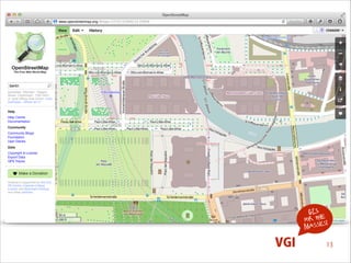
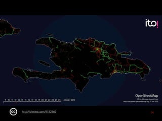
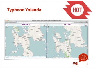
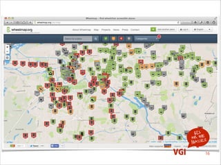
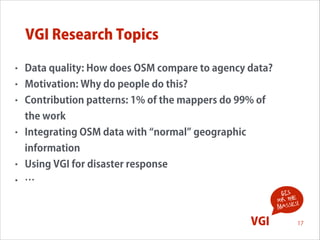
Volunteered geographic information 

(VGI) is the harnessing of tools to 

create, assemble, and 

disseminate geographic data 

provided voluntarily by 

individuals.


GIS
for the !
s
masse

http://en.wikipedia.org/wiki/VGI

VGI

3
Volunteered... what?
•

User generated geographic content

•

Came up with Web 2.0

•

Affordable GPS devices

•

Free (both as in free thought and as in free beer)

•

Faster

•

Non-authoritative

•

Labeled VGI by Mike Goodchild in 2007
!
GIS
for the !
s
masse
Michael F. Goodchild (2007) Citizens as sensors: the world of 

volunteered geography. GeoJournal 69(4): 211‒221

VGI

4
Some VGI Projects: WikiMapia

GIS
for the !
s
masse

VGI

5
Some VGI Projects: Google Maps Maker

GIS
for the !
s
masse

VGI

6
Twitter, Facebook, Foursquare, 

Flickr ‒ VGI?
•

Commercial platforms

•

Geographic information is often only a byproduct

•

Still often considered VGI

GIS
for the !
s
masse

VGI

7
GIS
for the !
s
masse

VGI

8
http://vimeo.com/62289901
Some VGI Projects: OpenStreetMap

GIS
for the !
s
masse

VGI

9
OpenStreetMap
•

The elephant in the room!

•

Started in 2004 by Steve Coast at University College London

•

Now operated by OpenStreetMap Foundation

•

1.4 million registered users

•

About 2 billion nodes and 200 million ways mapped

•

Data used at Mapquest, CartoDB, Foursquare, MapBox, ...

•

OSM dataset for the whole planet is currently 400GB
GIS
for the !
s
masse

VGI

10
Contributing to OpenStreetMap
•

Data imports

•

Record GPS tracks 

and upload them

•

Heads-up digitizing
!

GIS
for the !
s
masse

VGI

11
http://vimeo.com/31910541

12
GIS
for the !
s
masse

VGI

13
http://vimeo.com/9182869

14
Typhoon Yolanda

GIS
for the !
s
masse

VGI

15
GIS
for the !
s
masse

VGI

16
VGI Research Topics
•

Data quality: How does OSM compare to agency data?

•

Motivation: Why do people do this?

•

Contribution patterns: 1% of the mappers do 99% of
the work

•

Integrating OSM data with normal geographic
information

•

Using VGI for disaster response

•

…
GIS
for the !
s
masse

!

VGI

17
Quality Assessment

Carsten Keßler and René Theodore Anton de Groot (2013) Trust as a Proxy Measure for the Quality of 

Volunteered Geographic Information in the Case of OpenStreetMap. In Danny Vandenbroucke,

Bénédicte Bucher, and Joep Crompvoets: Geographic Information Science at the Heart of Europe. 

Proceedings the 16th AGILE Conference on Geographic Information Science, 14‒17 May 2013, Leuven, 

Belgium. Springer Lecture Notes in Geoinformation and Cartography 2013: 21‒37.

GIS
for the !
s
masse

VGI

18
Quality Assessment

GIS
for the !
s
masse

VGI

19
Quality Assessment

GIS
for the !
s
masse

VGI

20
Tracking Editing Processes

GIS
for the !
s
masse
Johannes Trame and Carsten Keßler (2011) Exploring the Lineage of Volunteered Geographic Information 

with Heat Maps. GeoViz 2011, Hamburg, Germany.

VGI

21
Tracking Editing Processes

Carsten Keßler, Johannes Trame and Tomi Kauppinen (2011) Tracking Editing Processes in Volunteered
Geographic Information: The Case of OpenStreetMap. In Matt Duckham, Antony Galton and Mike
Worboys (Eds.): Identifying Objects, Processes and Events in Spatio-Temporally Distributed Data (IOPE),
workshop at Conference on Spatial Information Theory 2011 (COSIT 11). 12 September 2011, Belfast, Maine, USA.

GIS
for the !
s
masse

VGI

22
VGI in Education

GIS
for the !
s
masse
Thomas Bartoschek and Carsten Keßler (2013) VGI in education: From K-12 to graduate studies. 

In Daniel Sui, Sarah Elwood, and Michael Goodchild (Eds.): Crowdsourcing Geographic Knowledge. 

Volunteered Geographic Information (VGI) in Theory and Practice, Part 3: 341‒360. Springer.

VGI

23
VGI in Education

GIS
for the !
s
masse

VGI

24
Semantic Referencing in VGI
•

Current approach in OSM: key-value pairs, e.g. amenity=cafe

•

Not handy if you look for a certain function of a place:
•
•

•

Do they have wifi?
Do they offer lunch?

Proposal: Functional descriptions instead of feature types

Simon Scheider, Carsten Keßler, Jens Ortmann, Anusuriya Devaraju, Johannes Trame, Tomi Kauppinen, 

Werner Kuhn (2011) Semantic Referencing of Geosensor Data and Volunteered Geographic Information. 

In Naveen Ashish and Amit Sheth (Eds.): Geospatial Semantics and Semantic-Web: Foundations, Algorithms, 

Applications. Springer book series, Semantic Web and Beyond: Computing for Human Experience, 

Vol. 12, pp.27‐59.

GIS
for the !
s
masse

VGI

25
Indoor VGI
•

Transfer the idea of OSM to indoor environments:
OpenFloorMap

•

Tool to capture and visualize indoor models in
OpenStreetMap

•

Project with 10 students for 2 semesters

GIS
for the !
s
masse

VGI

26
GIS
for the !
s
masse

VGI

27
Indirect VGI

Carsten Keßler, Patrick Maué, Jan Torben Heuer and Thomas Bartoschek (2009) Bottom-Up Gazetteers: 

Learning from the Implicit Semantics of Geotags. In Krzysztof Janowicz, Martin Raubal, and Sergei 

Levashkin: Third International Conference on GeoSpatial Semantics (GeoS 2009). December 3‒4 2009,
Mexico City. Springer Lecture Notes in Computer Science 5892: 83‒102.

GIS
for the !
s
masse

VGI

28
Indirect VGI

GIS
for the !
s
masse

VGI

29
Indirect VGI

GIS
for the !
s
masse

VGI

30
Wrapping up
•

VGI transfers the idea of the prosumer to geographic
information

•

Everybody can contribute ‒ no need to know a lot about GIS

•

Think about open vs. commercial

•

Technology in the hands of people has the potential to
produce data be used by everyone (not just those who can
afford a license)
!
GIS
for the !
s
masse

VGI

31
ank
Th
you!

Carsten Kessler
Hunter Geography Seminar ¦ Nov 18, 2013

GIS for the Masses: Volunteered Geographic Information

  • 1.
    Carsten Kessler Hunter GeographySeminar ¦ Nov 18, 2013 GIS r the fo sses! ma Volunteered Geographic Information
  • 2.
  • 3.
    Volunteered... what? Volunteered geographicinformation 
 (VGI) is the harnessing of tools to 
 create, assemble, and 
 disseminate geographic data 
 provided voluntarily by 
 individuals.
 
 GIS for the ! s masse http://en.wikipedia.org/wiki/VGI VGI 3
  • 4.
    Volunteered... what? • User generatedgeographic content • Came up with Web 2.0 • Affordable GPS devices • Free (both as in free thought and as in free beer) • Faster • Non-authoritative • Labeled VGI by Mike Goodchild in 2007 ! GIS for the ! s masse Michael F. Goodchild (2007) Citizens as sensors: the world of 
 volunteered geography. GeoJournal 69(4): 211‒221 VGI 4
  • 5.
    Some VGI Projects:WikiMapia GIS for the ! s masse VGI 5
  • 6.
    Some VGI Projects:Google Maps Maker GIS for the ! s masse VGI 6
  • 7.
    Twitter, Facebook, Foursquare,
 Flickr ‒ VGI? • Commercial platforms • Geographic information is often only a byproduct • Still often considered VGI GIS for the ! s masse VGI 7
  • 8.
  • 9.
    Some VGI Projects:OpenStreetMap GIS for the ! s masse VGI 9
  • 10.
    OpenStreetMap • The elephant inthe room! • Started in 2004 by Steve Coast at University College London • Now operated by OpenStreetMap Foundation • 1.4 million registered users • About 2 billion nodes and 200 million ways mapped • Data used at Mapquest, CartoDB, Foursquare, MapBox, ... • OSM dataset for the whole planet is currently 400GB GIS for the ! s masse VGI 10
  • 11.
    Contributing to OpenStreetMap • Dataimports • Record GPS tracks 
 and upload them • Heads-up digitizing ! GIS for the ! s masse VGI 11
  • 12.
  • 13.
  • 14.
  • 15.
  • 16.
  • 17.
    VGI Research Topics • Dataquality: How does OSM compare to agency data? • Motivation: Why do people do this? • Contribution patterns: 1% of the mappers do 99% of the work • Integrating OSM data with normal geographic information • Using VGI for disaster response • … GIS for the ! s masse ! VGI 17
  • 18.
    Quality Assessment Carsten Keßlerand René Theodore Anton de Groot (2013) Trust as a Proxy Measure for the Quality of 
 Volunteered Geographic Information in the Case of OpenStreetMap. In Danny Vandenbroucke,
 Bénédicte Bucher, and Joep Crompvoets: Geographic Information Science at the Heart of Europe. 
 Proceedings the 16th AGILE Conference on Geographic Information Science, 14‒17 May 2013, Leuven, 
 Belgium. Springer Lecture Notes in Geoinformation and Cartography 2013: 21‒37. GIS for the ! s masse VGI 18
  • 19.
  • 20.
  • 21.
    Tracking Editing Processes GIS forthe ! s masse Johannes Trame and Carsten Keßler (2011) Exploring the Lineage of Volunteered Geographic Information 
 with Heat Maps. GeoViz 2011, Hamburg, Germany. VGI 21
  • 22.
    Tracking Editing Processes CarstenKeßler, Johannes Trame and Tomi Kauppinen (2011) Tracking Editing Processes in Volunteered Geographic Information: The Case of OpenStreetMap. In Matt Duckham, Antony Galton and Mike Worboys (Eds.): Identifying Objects, Processes and Events in Spatio-Temporally Distributed Data (IOPE), workshop at Conference on Spatial Information Theory 2011 (COSIT 11). 12 September 2011, Belfast, Maine, USA. GIS for the ! s masse VGI 22
  • 23.
    VGI in Education GIS forthe ! s masse Thomas Bartoschek and Carsten Keßler (2013) VGI in education: From K-12 to graduate studies. 
 In Daniel Sui, Sarah Elwood, and Michael Goodchild (Eds.): Crowdsourcing Geographic Knowledge. 
 Volunteered Geographic Information (VGI) in Theory and Practice, Part 3: 341‒360. Springer. VGI 23
  • 24.
    VGI in Education GIS forthe ! s masse VGI 24
  • 25.
    Semantic Referencing inVGI • Current approach in OSM: key-value pairs, e.g. amenity=cafe • Not handy if you look for a certain function of a place: • • • Do they have wifi? Do they offer lunch? Proposal: Functional descriptions instead of feature types Simon Scheider, Carsten Keßler, Jens Ortmann, Anusuriya Devaraju, Johannes Trame, Tomi Kauppinen, 
 Werner Kuhn (2011) Semantic Referencing of Geosensor Data and Volunteered Geographic Information. 
 In Naveen Ashish and Amit Sheth (Eds.): Geospatial Semantics and Semantic-Web: Foundations, Algorithms, 
 Applications. Springer book series, Semantic Web and Beyond: Computing for Human Experience, 
 Vol. 12, pp.27‐59. GIS for the ! s masse VGI 25
  • 26.
    Indoor VGI • Transfer theidea of OSM to indoor environments: OpenFloorMap • Tool to capture and visualize indoor models in OpenStreetMap • Project with 10 students for 2 semesters GIS for the ! s masse VGI 26
  • 27.
  • 28.
    Indirect VGI Carsten Keßler,Patrick Maué, Jan Torben Heuer and Thomas Bartoschek (2009) Bottom-Up Gazetteers: 
 Learning from the Implicit Semantics of Geotags. In Krzysztof Janowicz, Martin Raubal, and Sergei 
 Levashkin: Third International Conference on GeoSpatial Semantics (GeoS 2009). December 3‒4 2009, Mexico City. Springer Lecture Notes in Computer Science 5892: 83‒102. GIS for the ! s masse VGI 28
  • 29.
    Indirect VGI GIS for the! s masse VGI 29
  • 30.
    Indirect VGI GIS for the! s masse VGI 30
  • 31.
    Wrapping up • VGI transfersthe idea of the prosumer to geographic information • Everybody can contribute ‒ no need to know a lot about GIS • Think about open vs. commercial • Technology in the hands of people has the potential to produce data be used by everyone (not just those who can afford a license) ! GIS for the ! s masse VGI 31
  • 32.