
Report
Share

Recommended
Hc. lab report presentation
Trichomoniasis is a common sexually transmitted infection caused by the protozoan Trichomonas vaginalis. In women, it causes vaginal infections and symptoms like discharge, itching, burning and odor. In men, it can cause urethral infections and burning after urination. While most men are asymptomatic, some experience discharge or burning. The infection is treated with antibiotics. Using condoms correctly during sex can help prevent transmission, as can limiting partners and abstaining from sex if infected.
Madagascar sow
This document analyzes the content knowledge covered in a Year 9 inquiry-based unit on Madagascar's uncertain future. It shows how students acquired foundational knowledge about Madagascar's location, development, and biodiversity in early lessons. Later lessons required applying and linking this content knowledge, as well as developing procedural knowledge through activities on illegal rosewood logging and sustainable decision making. The unit assessed students' understanding of why Madagascar faces an uncertain future based on three possible futures scenarios.
George and Sandy's Best of OAT Trip Heart of India March 2015
Pics taken during March 2015 OAT Trip "Heart of India" including Old and New Delhi, Jaipur, Agra, Ranthumbhore, Erotic Temples, and Varanasi
Trichomoniasis
This document summarizes the symptoms, signs, facts, treatment, and prognosis of trichomoniasis. Key symptoms in women include vaginal discharge and itching or swelling of the labia, while men may experience burning after urination. Diagnosis involves examining vaginal discharge under a microscope. Trichomoniasis is treated with antibiotics, and partners must be treated to prevent reinfection. Left untreated, it can increase HIV transmission risk.
Google Earth CPD Brighton
This document discusses using Google Earth to enhance geography teaching and learning. It provides examples of mapping data using polygons, embedding multimedia like videos and photos for geographical inquiry, and presenting fieldwork data. Specific skills are outlined, like using polygons and overlays to map crime data in London or rosewood logging in Madagascar. Presenting coastal fieldwork data is discussed using history mode, overlays and GE Graphs. The document also introduces tools for creating global thematic maps and presenting data with GE Graphs.
Geographical inquiry
The document discusses different perspectives on curriculum design and knowledge acquisition in geography education. It presents three potential futures for geography education: 1) "Govian Elitism" which focuses only on procedural knowledge, 2) A "Knowledge Society" which balances procedural, content, and core knowledge, and 3) "Objective Knowledge" which focuses only on core knowledge. The key idea is that students need all three types of knowledge (core, content, and procedural) to fully understand geography. Geographical inquiry is presented as a way to connect these different types of knowledge through activities that create needs to know, use data, make sense of information, and reflect on learning.
Multimedia Geography through Google Earth
This document discusses using Google Earth to teach multimedia geography. Google Earth allows students to explore the world through geolocated photos, videos, and audio. Examples are given of projects like tours of tribes, sporting events, biomes, and fieldwork. The document explains how to embed multimedia from sites like Flickr, YouTube, Audioboo, and others directly into Google Earth placemarks. It also describes using snapshot views to focus on embedded media. An example is given of an investigation into rosewood logging using geolocated materials from Madagascar, China, and the USA.
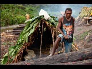
Loggers turn to bush meat as supplies run dry up
Loggers trapped inside Marojejy National Park with dwindling food supplies have turned to hunting lemurs, including critically endangered Silky Sifaka, to survive. One logger reported that they have run out of rice and have not been paid for dangerous work, floating heavy logs down rivers without equipment. The logger questioned why China, who receives the logs, does not help the loggers transport more logs out of the forest if they are benefiting from the operation.
The 'Knowledge Turn' in the UK National Curriculum
A presentation for staff at The Coopers' Company and Coborn School on the 'Knowledge Turn' in the National Curriculum
Madagscar Elvis Night
An Elvis tribute night will be held on February 24th from 7-10:30 pm at Coopers' Company and Coborn School Theatre to raise money to build a school in Madagascar. Tickets cost £12 each and can be purchased from George West or by completing the ticket request form and returning it with cash or a cheque made payable to Coopers' Company and Coborn School to Mrs. Clark in the finance office. The event will include musical entertainment, fun, games, dancing, and attendees should bring their own drinks and nibbles.
Bangladesh Climate Change
Bangladesh is highly vulnerable to climate change due to its location in a delta region with high population density and most areas being less than 5 meters above sea level. Climate change is expected to exacerbate existing threats like sea level rise, stronger cyclones, heavier monsoon rains, flooding from the Ganges and Brahmaputra Rivers, and drought in northern areas. This will negatively impact the lives and livelihoods of Bangladeshis, many of whom work in fishing and rice farming. Heavier rains could wash away homes and crops, while flooding and drought could destroy harvests and force people into debt.
Assembly Madagascar PPT
The Madagascar Expedition 2012 School Building Project aims to build a secondary school in Andranosoa Village, Madagascar with funds raised by UK students. A group of 34 year 12 and 13 students will travel to Madagascar in July-August 2012 to construct the school using £20,000 which will cover building materials, furniture, resources, and salaries for 2 teachers. The project seeks to help the country's vulnerable populations through education and is promoting fundraising efforts including raffles, events, and merchandise sales.
Madagascar Itinerary
The itinerary provides details for a 12 day expedition to Madagascar organized by The Coopers’ Company and Coborn School. The expedition involves multiple modes of transportation including flights, buses, and river trips. Activities include exploring national parks, participating in a village project, hiking, camping, and visiting local communities. Locations that will be visited include Andasibe National Park, Tsiribihina River, Bekopaka and the Tsingy de Bemaraha UNESCO site, Kirindy Forest Reserve, Mangily village, Belo sur Mer eco-lodge, Morondava, and the capital city of Antananarivo.
Example Word Document
This document provides an overview of a new marketing campaign for a client. The campaign will target customers ages 25-45 in major cities through Facebook ads, influencer marketing, and a new landing page on the company website. The goal is to increase brand awareness by 15% and online sales by 20% over the next 6 months through this multi-channel approach.
Sustainable Curitiba
The document discusses Curitiba's sustainable practices around recycling, transport, industry, parks, flood control, land use, and return home schemes. It describes how:
1) Curitiba has a unique recycling program called the "green swap" where residents can exchange recyclables for food/bus tickets at recycling points.
2) The city developed an extensive bus rapid transit system with dedicated lanes that over 75% of commuters use, reducing congestion.
3) An industrial city was built 10km outside Curitiba to avoid pollution and provide jobs for citizens.
4) The city turned flood plains into parks and increased green space to over 50 square meters per person to handle flooding and
Las Vegas: An Unsustainable City
Las Vegas is located in the Mojave Desert of Nevada, but has grown rapidly from a small rural town to a major urban center with a population of over 1.5 million. While surrounded by rural desert, Las Vegas itself is considered urban due to its large population and density. The rapid growth and development of Las Vegas has transformed what was once undeveloped desert into a sprawling city, through a process known as greenfield development on previously unused land. The city faces significant sustainability challenges associated with its arid desert location, including high water and energy consumption as well as impacts to local wildlife and climate change.
Migration UK
Migration has significantly changed the demographics of the UK. There are several types of migrants, including illegal migrants, displaced migrants, and voluntary migrants who move willingly. Recent trends show increases in UK migration, with migrants living and working predominantly in major cities like London. The population distribution shapes a pyramid structure, with more working-age migrants and fewer children or elderly, reflecting voluntary economic migration patterns.
Unit 1 Exam Question Revision
The document provides guidance for students taking Unit 1 Exam. It outlines the format which includes 6 short answer questions worth 65 marks total and 1 long answer question worth 25 marks from a choice of 4. It describes the different question types and offers tips to avoid common pitfalls like not carefully examining resource materials or misusing command words. Students are advised to spend no more than 1 hour on short answers and 30-35 minutes on the long response.
Crime in London
The document provides instructions for students to use Google Earth to map and analyze crime levels in different boroughs of London relative to their distance from central London. Students are asked to:
1) Map the total crime levels in different boroughs by changing the altitude of each borough polygon based on total crime numbers.
2) Color-code the boroughs based on levels of a specific crime chosen by the student.
3) Consider a map showing deprivation levels in London and examine whether there is a link between deprivation and crime levels.
Students are asked to take a screenshot of their final map, discuss whether the hypothesis that crime increases the closer one gets to central London is supported, and suggest other data that could
Flip Video
This document discusses ways that Flip Video cameras can be used to enhance teaching and learning. It provides examples of how Flip Videos can be used for starters and plenaries, mysteries, explaining concepts, discussions and debates, vox pops, assessing students, evaluating projects, conducting field work, supporting special needs and gifted students, staff training, and capturing student voice. It also covers editing videos and sharing them through websites like Vimeo and blogs to present results.
El Nino
El Niño Southern Oscillation (ENSO) is a climate pattern that occurs across the tropical Pacific Ocean approximately every 3 to 7 years, characterized by the warming of eastern Pacific Ocean waters and low atmospheric pressure in that region. El Niño events can have widespread global impacts, including severe droughts in some areas like the Philippines as well as floods in other regions such as California during the strong 1997-1998 El Niño when abnormally high sea levels caused hundreds of millions in flood damage in the San Francisco Bay area.
Powerpoint
The document outlines plans for an International Day event organized by a Geography Department to promote education for all globally. Students will be split into groups to create videos, case studies, and other materials for a new website called onegoal.tv. The website will highlight inequality in access to education worldwide and campaign for world leaders to commit to universal primary education by 2015, in line with UN Development Goal 2. Groups will produce an introductory video, case studies of countries making progress or struggling with education, a video wall with personal stories, a letter to world leaders, and a blog with ongoing coverage until 2015.
GeoIndia Presentation
The document summarizes an educational tour to Northern India organized by GeoIndia Tours. The 11-day tour will visit Rajasthan, Punjab, and Himachal Pradesh, focusing on religion, poverty, development, geography, history, and wildlife. It provides an itinerary, accommodation details, transport information, payment details, safety measures, and travel advice.
Unit 3 contested planet biodiversity under threat
The document discusses biodiversity under threat. It defines biodiversity as the variety of genes, species, and ecosystems in an area. Biodiversity hotspots are areas with high species richness and endemism that face severe threats. Major threats include deforestation, overfishing, pollution, invasive species, mining and climate change. Managing biodiversity involves sustainable use below maximum sustainable yields and conserving biodiversity hotspots, keystone species, and ecosystems through protected areas and international cooperation.
New Developments in Primary Geography
The document discusses developing a primary geography curriculum in schools. It introduces the Primary Geography Quality Mark, which is an award for schools that demonstrates quality in geography leadership, curriculum development, teaching and learning. It provides a self-assessment framework to help schools evaluate their geography program and identify areas for improvement. The framework is designed to improve the quality of geography education for all students and raise the profile of the subject in primary schools. It also discusses providing online professional development for geography leaders and teachers to support curriculum development.
Fishing in the Firth of Clyde
The document summarizes pressures facing the Firth of Clyde in Scotland including commercial fishing, tourism, sewage, and military activity. Cod, whiting, and haddock fisheries have collapsed with catches declining over 95%. Local divers formed COAST to help establish no-take zones in Lamlesh Bay to protect maerl and reverse fish declines. COAST aims to improve the marine environment, sustain tourism and fishing livelihoods, and increase the area's popularity. The no-take zones have caused some conflict between stakeholders who agree and disagree with the restrictions. The COAST project balances environmental, social, and economic considerations to work towards sustainability.
More Related Content
More from Mr Cornish
Loggers turn to bush meat as supplies run dry up
Loggers trapped inside Marojejy National Park with dwindling food supplies have turned to hunting lemurs, including critically endangered Silky Sifaka, to survive. One logger reported that they have run out of rice and have not been paid for dangerous work, floating heavy logs down rivers without equipment. The logger questioned why China, who receives the logs, does not help the loggers transport more logs out of the forest if they are benefiting from the operation.
The 'Knowledge Turn' in the UK National Curriculum
A presentation for staff at The Coopers' Company and Coborn School on the 'Knowledge Turn' in the National Curriculum
Madagscar Elvis Night
An Elvis tribute night will be held on February 24th from 7-10:30 pm at Coopers' Company and Coborn School Theatre to raise money to build a school in Madagascar. Tickets cost £12 each and can be purchased from George West or by completing the ticket request form and returning it with cash or a cheque made payable to Coopers' Company and Coborn School to Mrs. Clark in the finance office. The event will include musical entertainment, fun, games, dancing, and attendees should bring their own drinks and nibbles.
Bangladesh Climate Change
Bangladesh is highly vulnerable to climate change due to its location in a delta region with high population density and most areas being less than 5 meters above sea level. Climate change is expected to exacerbate existing threats like sea level rise, stronger cyclones, heavier monsoon rains, flooding from the Ganges and Brahmaputra Rivers, and drought in northern areas. This will negatively impact the lives and livelihoods of Bangladeshis, many of whom work in fishing and rice farming. Heavier rains could wash away homes and crops, while flooding and drought could destroy harvests and force people into debt.
Assembly Madagascar PPT
The Madagascar Expedition 2012 School Building Project aims to build a secondary school in Andranosoa Village, Madagascar with funds raised by UK students. A group of 34 year 12 and 13 students will travel to Madagascar in July-August 2012 to construct the school using £20,000 which will cover building materials, furniture, resources, and salaries for 2 teachers. The project seeks to help the country's vulnerable populations through education and is promoting fundraising efforts including raffles, events, and merchandise sales.
Madagascar Itinerary
The itinerary provides details for a 12 day expedition to Madagascar organized by The Coopers’ Company and Coborn School. The expedition involves multiple modes of transportation including flights, buses, and river trips. Activities include exploring national parks, participating in a village project, hiking, camping, and visiting local communities. Locations that will be visited include Andasibe National Park, Tsiribihina River, Bekopaka and the Tsingy de Bemaraha UNESCO site, Kirindy Forest Reserve, Mangily village, Belo sur Mer eco-lodge, Morondava, and the capital city of Antananarivo.
Example Word Document
This document provides an overview of a new marketing campaign for a client. The campaign will target customers ages 25-45 in major cities through Facebook ads, influencer marketing, and a new landing page on the company website. The goal is to increase brand awareness by 15% and online sales by 20% over the next 6 months through this multi-channel approach.
Sustainable Curitiba
The document discusses Curitiba's sustainable practices around recycling, transport, industry, parks, flood control, land use, and return home schemes. It describes how:
1) Curitiba has a unique recycling program called the "green swap" where residents can exchange recyclables for food/bus tickets at recycling points.
2) The city developed an extensive bus rapid transit system with dedicated lanes that over 75% of commuters use, reducing congestion.
3) An industrial city was built 10km outside Curitiba to avoid pollution and provide jobs for citizens.
4) The city turned flood plains into parks and increased green space to over 50 square meters per person to handle flooding and
Las Vegas: An Unsustainable City
Las Vegas is located in the Mojave Desert of Nevada, but has grown rapidly from a small rural town to a major urban center with a population of over 1.5 million. While surrounded by rural desert, Las Vegas itself is considered urban due to its large population and density. The rapid growth and development of Las Vegas has transformed what was once undeveloped desert into a sprawling city, through a process known as greenfield development on previously unused land. The city faces significant sustainability challenges associated with its arid desert location, including high water and energy consumption as well as impacts to local wildlife and climate change.
Migration UK
Migration has significantly changed the demographics of the UK. There are several types of migrants, including illegal migrants, displaced migrants, and voluntary migrants who move willingly. Recent trends show increases in UK migration, with migrants living and working predominantly in major cities like London. The population distribution shapes a pyramid structure, with more working-age migrants and fewer children or elderly, reflecting voluntary economic migration patterns.
Unit 1 Exam Question Revision
The document provides guidance for students taking Unit 1 Exam. It outlines the format which includes 6 short answer questions worth 65 marks total and 1 long answer question worth 25 marks from a choice of 4. It describes the different question types and offers tips to avoid common pitfalls like not carefully examining resource materials or misusing command words. Students are advised to spend no more than 1 hour on short answers and 30-35 minutes on the long response.
Crime in London
The document provides instructions for students to use Google Earth to map and analyze crime levels in different boroughs of London relative to their distance from central London. Students are asked to:
1) Map the total crime levels in different boroughs by changing the altitude of each borough polygon based on total crime numbers.
2) Color-code the boroughs based on levels of a specific crime chosen by the student.
3) Consider a map showing deprivation levels in London and examine whether there is a link between deprivation and crime levels.
Students are asked to take a screenshot of their final map, discuss whether the hypothesis that crime increases the closer one gets to central London is supported, and suggest other data that could
Flip Video
This document discusses ways that Flip Video cameras can be used to enhance teaching and learning. It provides examples of how Flip Videos can be used for starters and plenaries, mysteries, explaining concepts, discussions and debates, vox pops, assessing students, evaluating projects, conducting field work, supporting special needs and gifted students, staff training, and capturing student voice. It also covers editing videos and sharing them through websites like Vimeo and blogs to present results.
El Nino
El Niño Southern Oscillation (ENSO) is a climate pattern that occurs across the tropical Pacific Ocean approximately every 3 to 7 years, characterized by the warming of eastern Pacific Ocean waters and low atmospheric pressure in that region. El Niño events can have widespread global impacts, including severe droughts in some areas like the Philippines as well as floods in other regions such as California during the strong 1997-1998 El Niño when abnormally high sea levels caused hundreds of millions in flood damage in the San Francisco Bay area.
Powerpoint
The document outlines plans for an International Day event organized by a Geography Department to promote education for all globally. Students will be split into groups to create videos, case studies, and other materials for a new website called onegoal.tv. The website will highlight inequality in access to education worldwide and campaign for world leaders to commit to universal primary education by 2015, in line with UN Development Goal 2. Groups will produce an introductory video, case studies of countries making progress or struggling with education, a video wall with personal stories, a letter to world leaders, and a blog with ongoing coverage until 2015.
GeoIndia Presentation
The document summarizes an educational tour to Northern India organized by GeoIndia Tours. The 11-day tour will visit Rajasthan, Punjab, and Himachal Pradesh, focusing on religion, poverty, development, geography, history, and wildlife. It provides an itinerary, accommodation details, transport information, payment details, safety measures, and travel advice.
Unit 3 contested planet biodiversity under threat
The document discusses biodiversity under threat. It defines biodiversity as the variety of genes, species, and ecosystems in an area. Biodiversity hotspots are areas with high species richness and endemism that face severe threats. Major threats include deforestation, overfishing, pollution, invasive species, mining and climate change. Managing biodiversity involves sustainable use below maximum sustainable yields and conserving biodiversity hotspots, keystone species, and ecosystems through protected areas and international cooperation.
New Developments in Primary Geography
The document discusses developing a primary geography curriculum in schools. It introduces the Primary Geography Quality Mark, which is an award for schools that demonstrates quality in geography leadership, curriculum development, teaching and learning. It provides a self-assessment framework to help schools evaluate their geography program and identify areas for improvement. The framework is designed to improve the quality of geography education for all students and raise the profile of the subject in primary schools. It also discusses providing online professional development for geography leaders and teachers to support curriculum development.
Fishing in the Firth of Clyde
The document summarizes pressures facing the Firth of Clyde in Scotland including commercial fishing, tourism, sewage, and military activity. Cod, whiting, and haddock fisheries have collapsed with catches declining over 95%. Local divers formed COAST to help establish no-take zones in Lamlesh Bay to protect maerl and reverse fish declines. COAST aims to improve the marine environment, sustain tourism and fishing livelihoods, and increase the area's popularity. The no-take zones have caused some conflict between stakeholders who agree and disagree with the restrictions. The COAST project balances environmental, social, and economic considerations to work towards sustainability.
More from Mr Cornish (20)
The 'Knowledge Turn' in the UK National Curriculum
The 'Knowledge Turn' in the UK National Curriculum