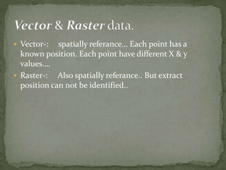
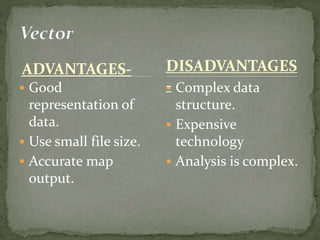
H.K.S.L.AKSHAMAL
USJP
• GIS……?????
Computer based system.
The term discribes information
system designed to capture, store,
edit, analysis,manage and display
all type of spatial or geographical
data………
 Computer
 Scaner
 Pen plotter
 Printer
 Spatial database- Those are spatially referance data.
Ex: roads, house, bus stop…
 Attribute database- They are not spatially referance.
But always add values for spatial data.
Data
queriee
Data
modelling
Decision
making
Real world
Data
input
 Forest cover monitoring.
 Resource inventory.
 Forest clasification.
 Damage assessment.
 Management plan preparation.
 Landuse planning and management.
 EIA
 Natural resource mapping. (Soil, water)
 Highway/Expressway mapping.
 Mineral exploration
 Quick reproduction in different scales.
 Easy interpretation.
 Quick update.
 Linking multi thematic maps.
 Accurate data.
 Better prediction and analysis.
 Expensive software.
 Difficult to intergrate with traditional maps.
 Scale manipulation. (zooming.)
 Map update.
 Logical operation.
 Reclassification of maps.
 Map overlay.
 Proximity analysis/ Buffer zone.
 Vector-: spatially referance… Each point has a
known position. Each point have different X & y
values….
 Raster-: Also spatially referance.. But extract
position can not be identified..
ADVANTAGES-
 Good
representation of
data.
 Use small file size.
 Accurate map
output.
 Complex data
structure.
 Expensive
technology
 Analysis is complex.
DISADVANTAGES
-
ADVANTAGES
 Simple data
structure.
 Cheap technology.
 Analysis is simple.
 Same grid cell for
several attribute.
 Large data volume.
 Inefficient use of
computer storage.
 Difficult network
analysis.
 Less accurate &
attractive maps.
 Loss of information
when using large cell.
DISADVANTAGES
THANK YOU………

GIS