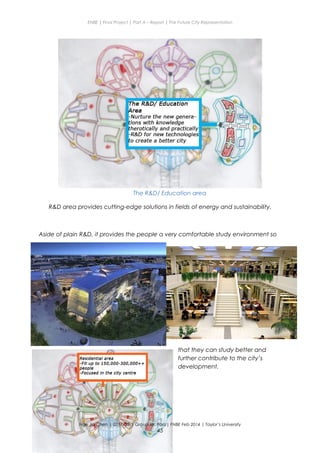
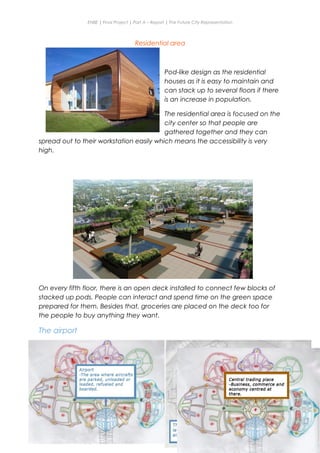
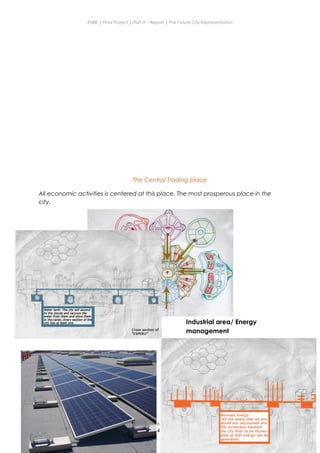
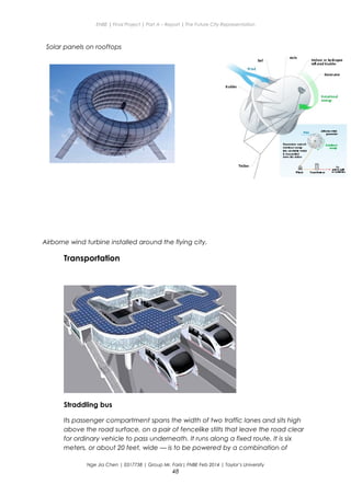
This document provides an overview and analysis of cities from ancient to modern times in order to inform the design of a future city. It examines the definitions, components, and characteristics of cities throughout history, including ancient cities like Mohenjo Daro and present-day cities like Sydney. Key aspects that make a city "good" are identified as resilience, inclusiveness, and authenticity. Sustainable practices are discussed as important considerations for future city development, with a focus on areas like sustainable energy, agriculture, and architecture. The document serves as background research to propose a new future city called ESPERO that addresses the shortcomings of the current city.
This document is a project report by Peerun Bibi Ameerah for a class called Foundation Program in Natural and Built Environment at Taylor's University in April 2013. The report proposes a design for a future city called "Sky-City" for the Malaysian population. It includes sections on the shape and zoning of the city, interior design, transportation, amenities, activities, and places of worship. The focus point of the city is a large nature park in the shape of a star located in the city center. The report provides details on how the city would be planned and organized to meet the needs of its residents.
This document discusses an ancient city called Mohenjo-daro as research for a student project to design a new future city. It provides background on Mohenjo-daro, including its history as a major city from the Indus Valley Civilization around 2600 BCE, and details of its advanced urban planning with a organized street grid layout and public buildings. The document analyzes what made Mohenjo-daro a significant ancient city and concludes that the student can draw on its well-planned grid structure for their new proposed future city design.
This document provides information about an ENBE final project report on designing a better livable town in Malaysia called SELPUTARIA. It discusses investigating ancient and present cities/towns to learn from their strengths and weaknesses. Key sections summarize the definition of cities and towns, what makes a good township, and the future of towns, which are expected to focus on sustainability and climate change adaptation. The document also examines the ancient Greek island of Thera and Phoenician city of Tyre to understand their historical urban planning.
This document provides guidelines for a final project in a course on natural and built environments. The project involves proposing a new town. It is divided into two parts:
Part A is an individual component requiring an A4 report and 3-minute video presentation proposing a basic plan for a new "X" Town.
Part B is a group component involving a physical model of the selected town and up to 3 presentation boards further explaining the proposal. Groups will choose from town types centered around a lake, river, island, or sea. The proposal must consider population size, zoning, infrastructure, sustainability, and other factors.
The document outlines objectives, learning outcomes, tasks, submission requirements, and assessment criteria for both parts
1. This document outlines the requirements for a two-part final project on built environments and future cities.
2. For Part A (individual), students must create a pamphlet and process journal proposing a new city called "X City".
3. For Part B (group), students will create a physical model and presentation boards further detailing their assigned "X City".
4. The project aims to have students investigate and propose elements of sustainable, livable future cities through these deliverables.
This document provides details about a student's final project for a class on better cities of the future. It includes an introduction describing the project requirements to plan a new city and produce a pamphlet. It then gives background information on what defines a city, the history of city formation, components of cities like networks and buildings, and common issues faced by modern cities. The document also summarizes the student's investigations into guidelines for better cities, and data collected on the ancient cities of Machu Picchu and Rome.
The document discusses the future of cities and sustainable city planning. It begins with an introduction to the assigned project to design a future city called City X. It then provides background on what defines a city, the history of cities, factors that make a good city, and case studies of the ancient city of Priene and current city planning approaches. The goal is to understand different city models and apply lessons from the past and present to create a sustainable design for City X to address the challenges of the future.
This document presents a report on planning a better livable town. It begins with an introduction describing the project of planning a new town as the current one has become overcrowded. It then examines the definitions and histories of towns and cities. Case studies of ancient, present and future towns are investigated, including Grammichele, Italy and Copenhagen, Denmark. The proposed new town, called "The Oasis," is presented with details on its hexagonal layout, zoning, transportation and sustainability features. The conclusion reflects on lessons learned about designing livable, harmonious communities.
Promoting Urban Environment Through Eco- CitiesJIT KUMAR GUPTA
Paper tries to define the role and importance of environmentally sustainable cities to promote urban environment , minimises carbon footprints and reduce global warmng
This document discusses sustainable urban development and building greener cities. It covers topics like sustainability, community planning, green buildings, mass transit, and planning with nature. The goal of sustainability is to meet present needs without compromising future generations' ability to meet their own needs. Sustainable community planning considers social, environmental, and economic impacts of policies. Tools like energy efficiency and conservation block grants can fund projects that reduce energy use and fossil fuel emissions.
Strategy and Options for Planning Inclusive CitiesJIT KUMAR GUPTA
Presentation looks at the context of inclusive cities, its relevance in the Indian context, problems faced by Indian cities and what are the options to make cities inclusive, and sustainable
The document describes a future underwater city called B.O.JOE. It was created after the mayor's original city was destroyed by animals who had turned immortal due to deforestation. B.O.JOE is located underwater for safety and provides everything its 100,000 citizens need, including jobs, schools, hospitals, parks, and energy from geothermal, solar, and biomass sources. It is shaped like a diamond to maximize light intake for agriculture. Transportation includes trains along straight lines with multiple stations. The city aims to provide a peaceful life for residents protected from disasters that affect land and air.
This document provides an overview of a student project to propose a better and livable town for Malaysians. It includes definitions of cities and towns, the differences between them, guidelines for townships, and concepts for future towns. Sections discuss investigating ancient and current towns as well as proposing a new town called "HEXICO" that incorporates sustainability principles. The document outlines the student's research process and relates the project to elements of the natural and built environment.
Human dimension & cities - The Human ScalePratham Pincha
This document discusses the concept of human scale in urban planning. It defines human scale as comprising three dimensions: population size, physical size of the space, and heterogeneity. Maintaining an ideal balance across these three dimensions has been a challenge for planners. The document argues that as city size and population increase, social relationships decrease and become more indirect. It examines how human scale affects individuals and their relationships within cities. Historical examples of efforts to define limits on city size and population are provided. The conclusion emphasizes the importance of considering scale in planning approaches to identify an appropriate human scale.
This document summarizes a student's final project report on proposing a better livable town. It includes an introduction outlining the project goals and requirements. Sections analyze the components of towns throughout history, including investigating ancient Rome and present-day Cape Town. Elements from these cities, such as hierarchical town planning, are identified for inclusion in the student's proposed future town design.
Making Cities Zero Carbon -- issues and optionJIT KUMAR GUPTA
Cities are known for their dualities and contradictions, positivity and negativities, inclusion and exclusion, poverty and prosperity, luxury housing and slums, planned and unplanned development, innovations and depravity, good and bad, pleasant and ugliness. All these contradictions are the outcome of the way we are planning, designing and managing cities. If cities are bringing prosperity, they are also creating global crisis. Majority of global ills of global warming, rising temperature, natural crisis is the outcome of how we are treating the cities. Cities are being conceived as anti-thesis to nature and accordingly they are creating crisis including crisis of very human existence. Cities need to be treated in a better and rational manner by planning and designing them in logical manner. Cities need to be looked as integral part of nature and not looked as a commodity for sale and making profit. Cities not to be treated as a market place where one hopes to earn money and generate wealth. They have to be looked as places for human living – giving human beings an environment, where they can lead happy and healthy life. Cities need to be planned with nature using natural resources. They need to be made more effective and efficient. Cities need to be made producers rather than consumers of natural and non-renewable resources. They need to be made more livable and supportive to human living and nature. Cities need respect and care. We need to heal its wounds. If cites continue to be treated like they are being treated now, they are going to become major source of impending crisis , making human living most challenging on this planet. Accordingly, we need to relook, review, redefine and revise our options of planning, travel and creating built environment.
This document provides an overview of a student's final project for a class on better cities of the future. It includes an introduction describing the two-part project and guidelines. Sections then cover investigations into what makes a city, better city guidelines and issues, data collected on ancient/old and present cities, and concepts for future cities. Examples discussed include Masdar City and a proposal for Athens. The document aims to understand elements of a sustainable smart city in order to plan a new city called Kardia.
Elmlund, P. - The importance of data innovation for analysis on citiesOECDregions
The importance of data innovation for analysis on cities - Peter Elmlund, Ax:son Jonson FoundatioWorkshop on Modernising Statistical Systems, OECD 2018.
This document is the newsletter of the International School of Urban Sciences (ISUS) at the University of Seoul.
It summarizes the 1st Global Friends Night event held by ISUS in August 2015, which was a homecoming party for current and alumni students. It also summarizes the SMG-UOS Global Urban Development Forum, also known as the Seoul Smart City Forum, held in December 2015. The forum brought together 100 experts from governments and companies to discuss urban development issues like transportation, disaster management, and e-government. Site visits were also made to local smart city facilities.
The purpose of this report is to take 50 of the world’s most prominent cities and look at how viable they are as places to live, their environmental impact, their financial stability, and how these elements complement one another.
All 50 of these brilliantly different cities are in various stages of evolution – some being further along the sustainability journey than others. Each possesses its own geolocation and cultural distinctions but shares common urban challenges in the areas of job creation, mobility, resiliency and improving the quality of life of its residents.
NB: Press Cutting Service
This article is culled from daily press coverage from around the world. It is posted on the Urban Gateway by way of keeping all users informed about matters of interest. The opinion expressed in this article is that of the author and in no way reflects the opinion of UN-Habitat
Author: ARCADIS
Category: Report
Role of Cities and towns as engines of Regional planning in KenyaPETER NAIBEI
This document discusses the roles and functions of towns and cities as engines of development in Kenya. It begins by defining regional planning and the criteria for classifying an area as a city. It then outlines the regional roles of towns/cities, including their social-cultural, economic, environmental, and political importance. The local roles of towns/cities are also examined, focusing on their roles in providing housing, work, recreation, transportation, and communication. In conclusion, the document stresses that urbanization is an inevitable part of development and that cities are more productive and provide greater infrastructure and opportunities than rural areas.
This document provides an overview of a course on the city as metabolism. It introduces key concepts about how cities can be understood as complex ecosystems and metabolic systems. It discusses how networks of resources, materials, and people flow within and sustain cities. It also addresses how the built environment and urban planning can influence a city's metabolism in positive or negative ways. The document outlines various assessment methods for the course, including quizzes, exams, and a personal research project. It includes a calendar of lecture topics that will cover definitions of metabolism, relevant social science theories, case studies of metabolic cities, and theoretical concepts relating urban flows and metabolism.
ENBE - Project 3 ( Final Project ) ~ Built Environments - A Better Future TownRyan Kerry Jy
The document is a report for a final project that proposes a better livable town called AINDCRAD. It includes an introduction, investigations of ancient and present towns, and characteristics of a future town. Specifically, it analyzes Pompeii for its efficient urban planning and water management, and Sylvan Lake Township in Canada for its utilization of a lake for recreation and agriculture. Elements that could be implemented in the new town include coordinated urban planning, utilizing existing water sources, and incorporating recreational green spaces.
An ecosystem refers to the community of organisms living together in the same habitat along with the non-living environment. It is made up of biotic components (living organisms) like producers, consumers, and decomposers, as well as abiotic components (non-living factors). There are usually multiple habitats within a single ecosystem, and the primary energy source for all living things is sunlight.
This document provides details about a student project to design a better livable town. It begins with background research on ancient Roman Paris and present-day Siem Reap Town in Cambodia to understand how they utilize water sources. This informs the design of a new proposed town called Allegro centered around a lake. The town aims to be self-sustainable, eco-friendly, and provide a comfortable living environment through green features and smart technology. Key aspects of the plan include zoning, transportation, green spaces, and ensuring sustainable water and energy supplies.
The document proposes an underground city. It summarizes an ancient underground city called Derinkuyu in Turkey that had 18 levels extending 60 meters deep and could shelter 20,000 people. Key features discussed are its ventilation shafts, tunnels, and wells to provide fresh water. These characteristics will influence the design of the proposed underground city. The document also briefly mentions another ancient underground city in Burlington, UK but provides few details. Overall the document researches and investigates existing underground cities as part of developing a proposal for a new underground city.
The document provides details about a future city project. It summarizes the history and elements of ancient cities like Babylon and Mohenjo-Daro. It then discusses the present cities of Tokyo and Seoul, focusing on Tokyo. Elements from Aincrad, a fictional floating castle from an anime, are also discussed. The document proposes a new floating city called "Orasul Etaje" for 150,000-500,000 Malaysian residents. Orasul Etaje would have 8 levels dedicated to different functions like government, public spaces, business, residences, and industry. Transportation would be provided by public buses, subways, and lifts between levels.
This document outlines the requirements for Project 1 of the Elements of Natural and Built Environment course. Students will visit Sungai Sedim Recreational Forest to explore and document the natural elements in a 10x10m site. They must then create an info graphic pop-up poster representing the site, a travelogue video of their experience, and an individual scrapbook journal. The poster and video are group works worth 20% and 5% respectively, while the journal is an individual 10% assignment. Students will be evaluated based on understanding the brief, content quality, creativity, and team collaboration.
The document provides information on the ancient city of Cairns, Australia and the present town of Ang Mo Kio in Singapore. Cairns started in 1876 and was founded to export gold from nearby areas. It developed into a tourism center with attractions like the Great Barrier Reef. Ang Mo Kio remained undeveloped until the 20th century rubber boom, and now has a population engaged in industries like agriculture. Both locations emphasize ecotourism and sustainable agriculture, with Cairns specifically focusing on protecting its natural environment while attracting visitors.
The document outlines a business plan to open a sports fashion retail shop called Implement Fashion Sports in Sunway Pyramid, Kuala Lumpur. The plan discusses collaborating with fashion designer Jeremy Scott and Adidas to customize sports jerseys. It analyzes the global and Malaysian sports industries, identifies potential competitors, and proposes marketing strategies such as celebrity endorsements and sports events. The financial plan projects sales, expenses, and profits over three years, with net profits of RM271,100 in year one and RM423,769 in year three. The management plan establishes an LLC structure with four owners.
This document provides an analysis of the existing structures and landscape at Cape Rachado site in Port Dickson, Malaysia. It describes the various site features including concrete pathways and steps, wood boundaries, metal railings, retaining walls, gazebos, benches, picnic tables and mangrove trees. Details are given on the materials, dimensions, strengths and weaknesses of each structure. The landscape section outlines the soil and vegetation conditions including different tree species found in the forest, beaches and along the shoreline.
This document summarizes research into the psychology behind the selfie culture. It discusses what a selfie is and why people take them. An experiment was conducted where participants rated people based on either an unflattering or flattering selfie photo of the same individual. Those who saw the better photo rated the person as more confident, attractive and friendly, showing how first impressions from selfies can influence perceptions through cognitive biases like the halo effect. The research aims to understand selfie-taking behaviors and how online self-presentation relates to psychological concepts like exposure effect, looking glass self, and fulfilling belongingness needs through social media likes.
Walter Gropius was a pioneering German architect and founder of the influential Bauhaus school. He studied architecture in the early 1900s and worked under influential architects before founding the Bauhaus in 1919. In the late 1930s, Gropius emigrated to the United States and became a professor at Harvard. For his family home built in 1938 in Lincoln, Massachusetts, Gropius combined elements of New England architecture with his modernist regionalist approach, creating a cubic house with a flat roof, large windows, and smooth surfaces while retaining regional redwood construction.
- The document describes a charity drive organized by students to raise money for World Vision by selling food products.
- The group sold muffins, chicken floss tarts, and longan puddings. Muffins were their primary product. Packaging highlighted the food and promoted an homemade feel.
- Pricing was set higher than costs to maximize profits for charity. Promotional strategies included free samples and face-to-face conversations, which drove many sales. The fundraiser was ultimately successful in raising money for the charity.
The document proposes constructing a two-story building on an unused site at Taylor's Lakeside Campus to provide additional services to students. The first floor would offer printing services, sports/recreational equipment rental, and a pharmacy. The second floor would sell electronic accessories. The building structure would be made of concrete and glass to allow views of inventory. It aims to conveniently serve students on campus who need printing, sports/recreation items, or small medications.
The document provides details for a landscape project located on the balcony of Block E, Level 7. It includes a site analysis noting strengths like wind flow and shade. The concept is to transform the empty balcony into a modern, relaxing green space. The master plan shows the layout including paths, plants like jasmine and lollipop trees. Construction details are provided for the walkway and slope. A maintenance plan outlines care needs for the plants and artificial grass.
The document compares and contrasts the animated films Kung Fu Panda and How to Train Your Dragon. Both films feature ordinary main characters, Po and Hiccup, who lack the abilities expected of them but experience life-changing events. People doubt and lack confidence in Po and Hiccup at first. However, both characters overcome this by turning their perceived weaknesses, Po's size and Hiccup's small stature, into strengths that allow them to defeat villains and become heroes.
This document summarizes a student project on the psychology behind taking selfies. It includes an introduction discussing the rise of selfies and how they are shared online. It then describes a skit and experiment conducted with students to study selfie culture. The skit portrayed the process of being exposed to selfies, taking a selfie, and sharing it online. The experiment showed students different selfies and surveyed their impressions. The discussion analyzes the skit and experiment results, linking concepts like mere exposure effect and looking glass self to motivations for taking and sharing selfies.
The document discusses the causes of students having little leisure time and feeling pressure to perform well in their studies. It states that the main causes are peer pressure to keep up with high-achieving friends, parental pressure to excel, and students' own poor study habits like procrastination. Addressing these issues could help reduce stress on students by allowing more free time and focusing on learning rather than grades.
This document provides an analysis of the Menara Tabung Haji building in Kuala Lumpur, Malaysia. It discusses the building's site context, architectural layout, construction materials, and various architectural elements. The building takes the form of an hourglass to symbolize spiritual enlightenment. It uses precast concrete, glass, and steel in its construction. Islamic influences are seen throughout the building's design, which combines traditional Malaysian elements with modern architecture.
This document outlines the sections of a report for a student project on designing a future city. The report introduces the project objectives of researching what makes livable cities and proposing a better future city. It also outlines sections that will investigate the definitions of cities, case studies of ancient, present and future cities, characteristics of good cities, a selected future city type, a proposed new city called "X City", and conclusions. The document provides an overview and structure for the various topics that will be covered in the full report.
This document provides information about an individual's final project proposal for an underground future city called "The Gold Zone". It includes sections on investigating ancient and present-day cities for inspiration. Key aspects of the proposed future city include using large ventilation shafts to provide air circulation underground, implementing water purification projects, and living underground to shelter from severe weather and radiation while being surrounded by gold from previous mining.
This document outlines the structure and content for a report on designing a better livable town. It includes sections that will investigate ancient, present and future towns to draw insights. The introduction describes the assigned project of building a model and report on a future city concept. It also discusses initial research conducted on what defines a city and factors that enhance lifestyle quality. The document provides guidelines on topics to cover such as zoning, infrastructure, sustainability initiatives and more. It emphasizes using references, images and diagrams to support the new city proposal.
This document provides an overview of a student's proposed better town of the future called Wolke. It begins with an introduction explaining the assignment to design a sustainable future town. It then reviews the definitions and elements of towns, both historically and what constitutes a good town. It examines examples of ancient and present towns. The document proposes that the most important element of future towns is survivability, with self-sufficient food, water and energy supplies. It suggests key elements for sustainable future towns like renewable energy, lower resource consumption, and green technology. In the end it introduces the new town of Wolke as the student's proposal for a better sustainable town.
This document provides an introduction and overview for a student's final project on designing a better livable town. It discusses the requirements of imagining being the mayor of a city called "X" in the year 2033, where the current city is no longer safe to live in. Students must create a situation requiring a new city and propose building the city underground, underwater, floating, or through urban enhancement. The document then provides background information on what defines a city and town historically and in the present, what makes a good township, and considerations for future towns, such as sustainability, security, balanced facilities, greenery, efficient transportation, technology, and renewable energy.
The document is a report on designing a better livable town called Spring Ville. It investigates guidelines for towns, and collects data on ancient, present and future towns. It examines Zhouzhuang, Menaggio, Dubai's Food City and Tianjin Eco City. The new town of Spring Ville will focus on sustainability with green buildings, roofs, and transportation like bicycles. It aims to address overcrowding with residential areas while preserving the environment.
This document is a report on a future city project. It discusses the history and elements of ancient, present and future cities. It focuses on the underground city of Montreal as an example from the present. For the future city, it proposes an underground city called Sphyx City located in Malaysia. Sphyx City would have different zones like residential, commercial, and agricultural areas to make it a livable future city.
The document is a report on the design of a future floating city called Emerald. It begins with an introduction explaining the purpose of the project is to propose a new city layout as the current city is no longer livable. It will include research on ancient, present and future cities. The report then provides definitions of what makes a city and discusses the brief history of cities. It also outlines what makes a good, sustainable future city. The document provides an investigation of the ancient city of Venice, including its founding date, expansion, impacts of war and disasters. It aims to understand city design and sustainability for the new floating city project.
This document discusses the future representation of cities and proposes building cities in alternative locations due to risks to existing cities. It describes an assignment where students imagine being the mayor of a city in 2033 that is no longer safe to live in due to some problem. The students must propose building a new city either underground, underwater, floating, or through city enhancement. It then provides background information on the definition and history of cities, as well as elements of urban design and infrastructure needed for smart cities.
ENBE Project 2 ( Final Project ) - Built Environments ~ A Better Future TownRyan Kerry Jy
This document presents a student project for a final report on representing a better livable town. It includes an introduction outlining the objectives of the assignment. Sections 2-5 investigate guidelines for towns/cities and include case studies of ancient, present and future towns. Section 6 proposes a new town called "Aindcrad" with a master plan, zoning, green space plans, and sketches. Sections 7-8 provide a conclusion and references. Case studies highlight efficient water management in Pompeii and recreational use/agriculture around Sylvan Lake. Elements from these cases may inform the design of the new sustainable town.
The document is a report on a future city project. It provides background on ancient, present and future cities as research for a new envisioned city called New Indron City. It discusses the history and elements of Baghdad, Tulsa and future underwater condos that will influence the design of New Indron City. The report also outlines the destruction of the original Indron Island city and the religious diversity of its population.
The document discusses the requirements for a final project proposing a future city. It begins with an introduction describing the goals of the project. It then discusses definitions of what makes a city, including population, infrastructure, and systems. It also examines characteristics of good, sustainable cities, and provides examples of ancient and present-day cities to draw lessons from, including Shibam and Amsterdam. The document aims to understand elements of city planning and propose a new future city that upholds sustainable living.
This document is a report on the future representation of a city. It begins with an introduction and definition of what makes a city. It then discusses investigating ancient cities like Babylon and its Hanging Gardens as well as Alexandria and its Lighthouse. Elements from these ancient cities like using plants and having a landmark structure are identified as being applicable to the new future city. The report also examines the modern city of Seoul, South Korea, focusing on the Dongdaemun Design Plaza and Parks. Features like balancing new and old, including green space, and having a central plaza are discussed as relevant to the new city. The goal is to incorporate relevant aspects from past and present cities to develop a sustainable new urban environment.
This document is a report on creating a better livable town called Lilyopolis. It begins with an introduction explaining the task is to project ideas for a more sustainable future town. Sections include investigating guidelines for ancient, present and future towns. For ancient towns, it focuses on Taormina, Italy, noting its beaches and popularity in the 19th century as a destination for male nude photographs. The goal is to understand features of past towns to design a new improved town that is eco-friendly and self-sustaining.
This document outlines Zoe Kan's research for a final project on representing a future city. It begins with an introduction and definitions of what makes a city and a good city. It then examines data collected on ancient cities like Babylon and its Hanging Gardens, and Egypt's Lighthouse of Alexandria. Elements from these ancient cities that could be implemented in the new city are discussed. Next, it analyzes aspects of modern Seoul, South Korea, focusing on the Dongdaemun Design Plaza and Parks. Elements from ancient and modern cities that could be incorporated into the new future city are highlighted.
This document provides an outline for a report on representing a future city. It begins with an introduction describing the mayor's responsibility to solve problems facing the city of "X" and plan for its citizens' future needs. It then reviews definitions of a city and its key elements. Several past and present cities are investigated, focusing on their water systems, geometric shapes, and energy sources. This information is considered for application to the new planned city. The document proposes that the mayor will name the rebuilt city the "Half-Sphere City" as it will be enclosed in a large glass shield for protection from climate disasters.
The document describes an ancient city of Machu Picchu located in Peru. It discusses some of the most impressive structures at the site including the Temple of the Sun and Temple of the Three Windows. It also mentions the important agricultural section of the city demonstrating advanced farming methods of the Inca people. The document states that Machu Picchu is surrounded by other sites forming the Inca Trail, some which require serious hiking but are well worth visiting.
This document outlines a student's final project for a class on town planning. It includes an introduction describing the project requirements to research and design a future livable town. It then covers investigations of ancient, present and future towns to gather inspiration. This includes analyses of the ancient town of Akrotiri and modern cities of Taipei and Copenhagen. It also explores the future of Tokyo. Based on these case studies, the student proposes a new town called "The Cape" on an island. The aims are for it to be livable and sustainable, combining agriculture, business and residences with a radial grid layout. The island location allows for renewable energy sources.
The document discusses the benefits of exercise for mental health. Regular physical activity can help reduce anxiety and depression and improve mood and cognitive function. Exercise causes chemical changes in the brain that may help protect against mental illness and improve symptoms for those who already suffer from conditions like depression and anxiety.
This project management report outlines a proposed handicraft heuristic centre for the Malaysian Handicraft Development Corporation. The 3-5 storey building located on Titiwangsa Lake Garden will provide 1800-2000 sqm of space for workshops, exhibitions, and public learning areas focused on sustaining Malaysian handicraft traditions. The design concept incorporates passive design, natural lighting and ventilation, and interactive public spaces. An open tendering process will be used to procure the project, which is estimated to cost RM7.2 million. The goals are to broaden the local economy, contribute to culture expansion, and demonstrate leadership in sustainability.
This document provides details of a proposed recreational station project for a university, including:
1. The client, Taylor's Management, has approached the architectural firm Wabi Sabi Associates to design and build a recreational station for students by August 2018 on an existing parking site.
2. The project objectives, budget of RM1.5 million, and requirements including recreational and operational facilities are outlined.
3. The project management plan includes success criteria focusing on being on time and on budget, a work breakdown structure dividing tasks among architects, landscape architects, civil/structural engineers and MEP engineers, and a Gantt chart and PERT chart to monitor schedule and risks.
4. Details of the
The document summarizes four texts related to architectural theory:
1) The Geometry of Feeling argues that architecture should communicate emotive experiences rather than just being physical objects. It should evoke sensory memories and feelings.
2) Learning from Las Vegas discusses how symbolism dominates architecture in Las Vegas and questions how commercialization affects design. Symbols create better spatial relationships than forms.
3) Towards a Critical Regionalism proposes responding to the peculiarities of place, like topography and climate, rather than seeking placelessness. It advocates a dialectical relationship with nature.
4) Tactile qualities are an essential part of how we perceive architecture, not just visual elements. Critical regionalism aims to complement visual experience with tact
The document provides a comparative analysis of two streets - Sejong-no in Seoul, South Korea and Jalan Tuanku Abdul Rahman in Kuala Lumpur, Malaysia. Both streets serve as important nodes within their cities and share a similar linear urban configuration. The analysis examines the streets based on theories of human scale, necessary and optional activities, and contact points to determine the criteria for a good urban habitat. Key contact points are identified along Sejong-no that increase walkability and human interaction.
Kuala Lumpur began as tin mining sites along the Klang and Gombak Rivers in the late 1800s. As the mining industry grew, the city developed an urban pattern centered around transportation needs. By the 1920s, Kuala Lumpur had transitioned to a major administrative and business center. Today, the city is densely built up with mid-to-high rise buildings, though some heritage areas have been preserved. Jalan TAR remains an important arterial road connecting various districts. Authorities are working to revitalize the Klang River. The document analyzes the urban morphology and human experience of spaces in Kuala Lumpur over time.
The document provides an analysis of the acoustic design of an auditorium (PJCC auditorium). It begins with an introduction to the site and technical drawings. It then reviews relevant acoustic concepts such as sound pressure level, sound reduction index, and reverberation time. It identifies existing sound sources in the auditorium like external noise, internal noise, and the sound reinforcement system. It discusses sound path principles and how they are applied in the auditorium design through elements like the balcony, walls, and raked floor. It also covers acoustic materials and calculations of absorption coefficients and reverberation time. The document aims to understand and explore the acoustic characteristics of the auditorium in order to analyze and suggest improvements to the acoustic qualities.
This document provides details on the lighting design integration project for a community library in Kuala Lumpur. It analyzes the daylight factor of two key spaces - the computer room and human library. It then examines the artificial lighting requirements for these spaces using the lumen method and room index calculation. LED suspended ceiling lights are selected to provide supplementary lighting as needed.
This document provides an analysis of the townscapes of Malacca and Georgetown in four parts:
Part 1 examines the key characteristics of Malacca and Georgetown during the colonial era, noting similarities in their urban configurations which segregated races and located administrative buildings strategically. Both towns also had a "Harmony Street" cutting through the grid.
Part 2 theorizes Kuala Lumpur's development, comparing its colonialism to features in Malacca and Georgetown. Keywords are connected to Jalan Tun H.S. Lee.
Part 3 describes Kuala Lumpur as a "collage city" through its demographics, vibrant townscape, dominance
The document discusses the urban morphology and street typology of three historic cities in Malacca, Malaysia - St. Paul's Civic Zone, Jonker Street, and Harmony Street. It describes the different land uses, building types, and religious structures that characterized each area. Notably, St. Paul's Civic Zone contained governing buildings and the Portuguese fortress, Jonker Street was a commercial area for wealthy families, and Harmony Street had craftsman shops and religiously diverse buildings. The document uses these three streets to analyze patterns of urban development, land use, movement, and the public/private realms in a historically significant Southeast Asian city.
This architectural document contains plans and elevations for a building project. It includes 3 different elevation views of the building as well as a plan view to show the layout. The elevations and plan provide key visual information about the design and dimensions of the structure.
The document provides details on Nge Jia Chen's 2 month internship at Archimetry Sdn. Bhd., including responsibilities in schematic design projects for a school master plan and townhouse layout, as well as learning Lumion for rendering. Key responsibilities included calculating land areas, proposing classroom arrangements and layouts, and conceptual sketches and renderings. The internship provided valuable practical experience in various phases of an architectural project.
The document summarizes a student project to analyze the structure of a two-story bungalow. It includes architectural plans of the ground floor, first floor, and roof. It outlines the design brief with assumptions made for dead and live loads on various building components. Structural plans, load distribution diagrams, and tributary diagrams are presented to analyze the load paths. The document is a school assignment where students are required to apply structural theory to frame the building and prepare necessary structural drawings.
The document provides proposals for building service systems for an old folks home. It analyzes and proposes solutions for fire protection, air conditioning, mechanical ventilation, and transportation systems. For fire protection, it recommends both active and passive systems. The active systems proposed include automatic detection and alarm systems using ionization smoke detectors, heat detectors, and a two-stage fire alarm. Fire suppression is proposed through dry chemical extinguishers and a dry riser system. Passive protections like compartmentalization and fire escapes are also discussed. Air conditioning, ventilation, and an elevator system are also proposed and analyzed in detail to suit the needs of the elderly home.
This document discusses the application of critical regionalism in the design of Menara Mesiniaga, a skyscraper in Malaysia. It begins with an introduction to critical regionalism, which aims to counter the lack of meaning and placelessness of modern architecture by incorporating local contextual elements. The influence of critical regionalism in Malaysian architecture is then explored through examples like Menara Mesiniaga, Menara Dayabumi, and the Petronas Twin Towers. The document examines how critical regionalism has been applied to the skyscraper typology through case studies. It then analyzes the similarities and differences between Menara Mesiniaga and a generic skyscraper, highlighting how the former incorporates influences from vernacular Malay architecture through its
This document provides information about Bukit Cina in Malacca, Malaysia. It includes a site analysis of three potential development sites at Bukit Cina. Site 1 is flat with trees for shade but the area is small. Site 2 has views blocked by buildings and is windy. Site 3 has the best sun and wind orientation. The document also gives background on Bukit Cina's history as a Chinese cemetery. It describes the local context, including religious buildings, markets, and residential areas. Human activities at Bukit Cina include operating businesses, jogging, and gathering at the wet market.
This document lists 8 students and their student IDs as members of a group. The students include Aida Junita Binti Zulkiflee, Amos Tan Chi Yi, Benjamin Cheng Jia Yeow, Bridget Tan Su Ting, Khor Yen Min, Lee Czen Shing, Nge Jia Chen, and Wong Zhen Fai.
The document provides information on the foundation design and construction for a building project. It discusses different types of foundations including strip footing, which is a continuous strip of concrete placed under load bearing walls to spread the building load. Details are given on the reference design and on-site construction of the foundation, including excavation, formwork, reinforcement, and concrete pouring. Quality control measures are emphasized to ensure the strength and stability of the foundation.
Social psychology assignment 1 (journal entries)Nge Chen
This document contains four journal entries by a student about topics in social psychology. The first entry discusses social facilitation and provides examples of co-action and audience effects from the student's personal experiences working on a group project and playing basketball. The second entry discusses intrinsic and extrinsic motivation, providing the student's story of losing weight for both intrinsic and extrinsic reasons. The third entry discusses heuristics and provides examples of availability and representativeness heuristics from the student's experiences deciding on transportation for a trip and making judgments of others. The fourth entry discusses attribution and types of attribution errors like self-serving bias and fundamental attribution error.
Recycling and Disposal on SWM Raymond Einyu pptxRayLetai1
Increasing urbanization, rural–urban migration, rising standards of living, and rapid development associated with population growth have resulted in increased solid waste generation by industrial, domestic and other activities in Nairobi City. It has been noted in other contexts too that increasing population, changing consumption patterns, economic development, changing income, urbanization and industrialization all contribute to the increased generation of waste.
With the increasing urban population in Kenya, which is estimated to be growing at a rate higher than that of the country’s general population, waste generation and management is already a major challenge. The industrialization and urbanization process in the country, dominated by one major city – Nairobi, which has around four times the population of the next largest urban centre (Mombasa) – has witnessed an exponential increase in the generation of solid waste. It is projected that by 2030, about 50 per cent of the Kenyan population will be urban.
Aim:
A healthy, safe, secure and sustainable solid waste management system fit for a world – class city.
Improve and protect the public health of Nairobi residents and visitors.
Ecological health, diversity and productivity and maximize resource recovery through the participatory approach.
Goals:
Build awareness and capacity for source separation as essential components of sustainable waste management.
Build new environmentally sound infrastructure and systems for safe disposal of residual waste and replacing current dumpsites which should be commissioned.
Current solid waste management situation:
The status.
Solid waste generation rate is at 2240 tones / day
collection efficiently is at about 50%.
Actors i.e. city authorities, CBO’s , private firms and self-disposal
Current SWM Situation in Nairobi City:
Solid waste generation – collection – dumping
Good Practices:
• Separation – recycling – marketing.
• Open dumpsite dandora dump site through public education on source separation of waste, of which the situation can be reversed.
• Nairobi is one of the C40 cities in this respect , various actors in the solid waste management space have adopted a variety of technologies to reduce short lived climate pollutants including source separation , recycling , marketing of the recycled products.
• Through the network, it should expect to benefit from expertise of the different actors in the network in terms of applicable technologies and practices in reducing the short-lived climate pollutants.
Good practices:
Despite the dismal collection of solid waste in Nairobi city, there are practices and activities of informal actors (CBOs, CBO-SACCOs and yard shop operators) and other formal industrial actors on solid waste collection, recycling and waste reduction.
Practices and activities of these actor groups are viewed as innovations with the potential to change the way solid waste is handled.
CHALLENGES:
• Resource Allocation.
Improving the viability of probiotics by encapsulation methods for developmen...Open Access Research Paper
The popularity of functional foods among scientists and common people has been increasing day by day. Awareness and modernization make the consumer think better regarding food and nutrition. Now a day’s individual knows very well about the relation between food consumption and disease prevalence. Humans have a diversity of microbes in the gut that together form the gut microflora. Probiotics are the health-promoting live microbial cells improve host health through gut and brain connection and fighting against harmful bacteria. Bifidobacterium and Lactobacillus are the two bacterial genera which are considered to be probiotic. These good bacteria are facing challenges of viability. There are so many factors such as sensitivity to heat, pH, acidity, osmotic effect, mechanical shear, chemical components, freezing and storage time as well which affects the viability of probiotics in the dairy food matrix as well as in the gut. Multiple efforts have been done in the past and ongoing in present for these beneficial microbial population stability until their destination in the gut. One of a useful technique known as microencapsulation makes the probiotic effective in the diversified conditions and maintain these microbe’s community to the optimum level for achieving targeted benefits. Dairy products are found to be an ideal vehicle for probiotic incorporation. It has been seen that the encapsulated microbial cells show higher viability than the free cells in different processing and storage conditions as well as against bile salts in the gut. They make the food functional when incorporated, without affecting the product sensory characteristics.
Climate Change All over the World .pptxsairaanwer024
Climate change refers to significant and lasting changes in the average weather patterns over periods ranging from decades to millions of years. It encompasses both global warming driven by human emissions of greenhouse gases and the resulting large-scale shifts in weather patterns. While climate change is a natural phenomenon, human activities, particularly since the Industrial Revolution, have accelerated its pace and intensity
Evolving Lifecycles with High Resolution Site Characterization (HRSC) and 3-D...Joshua Orris
The incorporation of a 3DCSM and completion of HRSC provided a tool for enhanced, data-driven, decisions to support a change in remediation closure strategies. Currently, an approved pilot study has been obtained to shut-down the remediation systems (ISCO, P&T) and conduct a hydraulic study under non-pumping conditions. A separate micro-biological bench scale treatability study was competed that yielded positive results for an emerging innovative technology. As a result, a field pilot study has commenced with results expected in nine-twelve months. With the results of the hydraulic study, field pilot studies and an updated risk assessment leading site monitoring optimization cost lifecycle savings upwards of $15MM towards an alternatively evolved best available technology remediation closure strategy.
Presented by The Global Peatlands Assessment: Mapping, Policy, and Action at GLF Peatlands 2024 - The Global Peatlands Assessment: Mapping, Policy, and Action
Epcon is One of the World's leading Manufacturing Companies.EpconLP
Epcon is One of the World's leading Manufacturing Companies. With over 4000 installations worldwide, EPCON has been pioneering new techniques since 1977 that have become industry standards now. Founded in 1977, Epcon has grown from a one-man operation to a global leader in developing and manufacturing innovative air pollution control technology and industrial heating equipment.
Optimizing Post Remediation Groundwater Performance with Enhanced Microbiolog...Joshua Orris
Results of geophysics and pneumatic injection pilot tests during 2003 – 2007 yielded significant positive results for injection delivery design and contaminant mass treatment, resulting in permanent shut-down of an existing groundwater Pump & Treat system.
Accessible source areas were subsequently removed (2011) by soil excavation and treated with the placement of Emulsified Vegetable Oil EVO and zero-valent iron ZVI to accelerate treatment of impacted groundwater in overburden and weathered fractured bedrock. Post pilot test and post remediation groundwater monitoring has included analyses of CVOCs, organic fatty acids, dissolved gases and QuantArray® -Chlor to quantify key microorganisms (e.g., Dehalococcoides, Dehalobacter, etc.) and functional genes (e.g., vinyl chloride reductase, methane monooxygenase, etc.) to assess potential for reductive dechlorination and aerobic cometabolism of CVOCs.
In 2022, the first commercial application of MetaArray™ was performed at the site. MetaArray™ utilizes statistical analysis, such as principal component analysis and multivariate analysis to provide evidence that reductive dechlorination is active or even that it is slowing. This creates actionable data allowing users to save money by making important site management decisions earlier.
The results of the MetaArray™ analysis’ support vector machine (SVM) identified groundwater monitoring wells with a 80% confidence that were characterized as either Limited for Reductive Decholorination or had a High Reductive Reduction Dechlorination potential. The results of MetaArray™ will be used to further optimize the site’s post remediation monitoring program for monitored natural attenuation.
Microbial characterisation and identification, and potability of River Kuywa ...Open Access Research Paper
Water contamination is one of the major causes of water borne diseases worldwide. In Kenya, approximately 43% of people lack access to potable water due to human contamination. River Kuywa water is currently experiencing contamination due to human activities. Its water is widely used for domestic, agricultural, industrial and recreational purposes. This study aimed at characterizing bacteria and fungi in river Kuywa water. Water samples were randomly collected from four sites of the river: site A (Matisi), site B (Ngwelo), site C (Nzoia water pump) and site D (Chalicha), during the dry season (January-March 2018) and wet season (April-July 2018) and were transported to Maseno University Microbiology and plant pathology laboratory for analysis. The characterization and identification of bacteria and fungi were carried out using standard microbiological techniques. Nine bacterial genera and three fungi were identified from Kuywa river water. Clostridium spp., Staphylococcus spp., Enterobacter spp., Streptococcus spp., E. coli, Klebsiella spp., Shigella spp., Proteus spp. and Salmonella spp. Fungi were Fusarium oxysporum, Aspergillus flavus complex and Penicillium species. Wet season recorded highest bacterial and fungal counts (6.61-7.66 and 3.83-6.75cfu/ml) respectively. The results indicated that the river Kuywa water is polluted and therefore unsafe for human consumption before treatment. It is therefore recommended that the communities to ensure that they boil water especially for drinking.
ENVIRONMENT~ Renewable Energy Sources and their future prospects.tiwarimanvi3129
This presentation is for us to know that how our Environment need Attention for protection of our natural resources which are depleted day by day that's why we need to take time and shift our attention to renewable energy sources instead of non-renewable sources which are better and Eco-friendly for our environment. these renewable energy sources are so helpful for our planet and for every living organism which depends on environment.
Kinetic studies on malachite green dye adsorption from aqueous solutions by A...Open Access Research Paper
Water polluted by dyestuffs compounds is a global threat to health and the environment; accordingly, we prepared a green novel sorbent chemical and Physical system from an algae, chitosan and chitosan nanoparticle and impregnated with algae with chitosan nanocomposite for the sorption of Malachite green dye from water. The algae with chitosan nanocomposite by a simple method and used as a recyclable and effective adsorbent for the removal of malachite green dye from aqueous solutions. Algae, chitosan, chitosan nanoparticle and algae with chitosan nanocomposite were characterized using different physicochemical methods. The functional groups and chemical compounds found in algae, chitosan, chitosan algae, chitosan nanoparticle, and chitosan nanoparticle with algae were identified using FTIR, SEM, and TGADTA/DTG techniques. The optimal adsorption conditions, different dosages, pH and Temperature the amount of algae with chitosan nanocomposite were determined. At optimized conditions and the batch equilibrium studies more than 99% of the dye was removed. The adsorption process data matched well kinetics showed that the reaction order for dye varied with pseudo-first order and pseudo-second order. Furthermore, the maximum adsorption capacity of the algae with chitosan nanocomposite toward malachite green dye reached as high as 15.5mg/g, respectively. Finally, multiple times reusing of algae with chitosan nanocomposite and removing dye from a real wastewater has made it a promising and attractive option for further practical applications.
Kinetic studies on malachite green dye adsorption from aqueous solutions by A...
Fp part a - report template
1. ENBE | Final Project | Part A – Report | The Future City Representation
Better Cities of the Future
ESPERO
The City of Hope
Nge Jia Chen | 0317738
Nge Jia Chen | 0317738 | Group Mr. Fariz| FNBE Feb 2014 | Taylor’s University
1
2. ENBE | Final Project | Part A – Report | The Future City Representation
FNBE FEB 2014
Content:
1. Introduction………………………………………………………………………………….. 3
2. A City Investigation on Better City Guidelines and Issues…………………………...4
3. Investigation & Data Collection: Ancient cities (Mohenjo Daro)…………………...9
4. Investigation & Data Collection: Present city (City of Sydney).……………………16
5. Investigation & Data Collection: The future city (Masdar city)……….……………23
6. Case study on the selected type of the future city…………………………………..30
7. The New “X” City, ESPERO
………………………………………………………………..31
8. The Conclusion………………………………………………………………………………41
9. References list……………………………………………………………………………….42
Nge Jia Chen | 0317738 | Group Mr. Fariz| FNBE Feb 2014 | Taylor’s University
2
3. ENBE | Final Project | Part A – Report | The Future City Representation
1.Introduction
In this project, I am required to pretend that I am the mayor of
the “X” city and to propose a better future city for the people because
Nge Jia Chen | 0317738 | Group Mr. Fariz| FNBE Feb 2014 | Taylor’s University
3
4. ENBE | Final Project | Part A – Report | The Future City Representation
the city is no longer livable. In order to create a better city, I will have
to find out what a city is, its development and history, components,
elements and what makes a better city.
This project is aimed to expose us on how to design a sustainable
and livable city for the people. People ignore design that ignores
people. Hence, we have to design a place that suits the people
needs. In order to do so, I have to do researches on city planning.
After doing the comprehensive researches on what makes a
better city, I am required to produce a report to demonstrate my
understandings and the collection of data on what a city is.
Nge Jia Chen | 0317738 | Group Mr. Fariz| FNBE Feb 2014 | Taylor’s University
4
5. ENBE | Final Project | Part A – Report | The Future City Representation
2.The City
2.1 The city definition
A city is a relatively permanent and highly organized center of
population, of greater size or importance than a town or village. Think of the
complexity of road systems, transportation, building laws, markets, food
distribution, educational systems, etc., and you get an idea of what is meant
by that statement. But that complexity didn't spring up overnight. It is the
result of long years of human development.
Nge Jia Chen | 0317738 | Group Mr. Fariz| FNBE Feb 2014 | Taylor’s University
5
6. ENBE | Final Project | Part A – Report | The Future City Representation
For instance, the city of Kuala Lumpur, in the 1850s, it was nothing but a
large tin mine. Through years of development, it became the federal capital
and most populous city in Malaysia. It is also an urban agglomeration of 6.9
million. It is among the fastest growing metropolitan regions in the country, in
terms of population and economy. In a nutshell, it took over a century to
spring up to what it seems today.
2.2 Brief history of city
The first cities appeared in
Neolithic times when the
development of agricultural
techniques assured surplus crop
yields large enough to sustain a
permanent populations. Ancient
Greece saw the creation of the
city-
state,
Nge Jia Chen | 0317738 | Group Mr. Fariz| FNBE Feb 2014 | Taylor’s University
6
7. ENBE | Final Project | Part A – Report | The Future City Representation
a form also important in the emergence of the Roman Empire as well as the
medieval Italian trading centers of Venice, Genoa, and Florence. After The
Middle Ages, cities came increasingly under the political control of
centralized government and served the interests of the nation-state. The
Industrial Revolution further transformed city life, as factory cities blossomed
rapidly in England, northwestern Europe, and the northeastern U.S. By the
mid-20th century, 30–60% of a country’s population might be living in its major
urban centers. With the rise of the automobile came the growth of suburbs
and urban sprawl, as factories, offices, and residences erected in earlier
periods became paged and obsolete. Today many cities suffer from lack of
adequate housing, sanitation, recreational space, and transportation
facilities, and face problems of inner-city decay or burgeoning shantytowns.
Local governments have sought to alleviate these problems through urban
planning.
2.3 What makes a city?
A city has professional administrators, regulations, and some form of
taxation (food and other necessities or means to trade for them) to feed the
government workers. The governments may be based on heredity, religion,
military power, work projects (such as canal building), food distribution, land
ownership, agriculture, commerce, manufacturing, finance, or a
combination of those.
Nge Jia Chen | 0317738 | Group Mr. Fariz| FNBE Feb 2014 | Taylor’s University
7
8. ENBE | Final Project | Part A – Report | The Future City Representation
Besides that, a city consists of infrastructures and facilities for the
citizens. A city is also a place where human activities centered. Education is
centered at the city too. Last but not least, societies that live in cities are
often called civilizations.
2.4 What makes a good city?
Nge Jia Chen | 0317738 | Group Mr. Fariz| FNBE Feb 2014 | Taylor’s University
8
9. ENBE | Final Project | Part A – Report | The Future City Representation
Now we know what a city is, but what is a good city? A good city
achieves resilience, inclusiveness and authenticity.
Resilience focuses on adaptability, flexibility and balance. It is about the
ability of a city to ‘invent’ or ‘re-invent’ itself through shocks and stresses to
harmoniously accommodate old and new values and to adapt the functions
and requirements of the city. It illustrate a city’s capacity to balance
continuity with change, heritage and innovation, natural spaces and the
urban environment to the benefit of its inhabitants.
Inclusiveness is about creating social integration and cohesion. Inclusive
cities are open for participation from the widest range of civil society,
irrespective to gender, age, ethnicity, cultural heritage, beliefs, religions and
economic status. Inhabitants should have equal opportunities to participate
in the activities of the city. Inclusiveness enhances community feelings, the
sense of ownership to the city, the sense of belonging to that place.
Nge Jia Chen | 0317738 | Group Mr. Fariz| FNBE Feb 2014 | Taylor’s University
9
10. ENBE | Final Project | Part A – Report | The Future City Representation
Authenticity is the ability to maintain the local character of the city, the local
heritage, culture and environment. At the same time, a city needs to
accommodate social, economic and technological changes – and evolves
itself. The evolution needs to be sustainable and match the expectations of
the citizens.
Nge Jia Chen | 0317738 | Group Mr. Fariz| FNBE Feb 2014 | Taylor’s University
10
11. ENBE | Final Project | Part A – Report | The Future City Representation
2.5 What is future cities?
Nge Jia Chen | 0317738 | Group Mr. Fariz| FNBE Feb 2014 | Taylor’s University
11
12. ENBE | Final Project | Part A – Report | The Future City Representation
So what is future cities? There are no real definition on what is a future city.
We are still working towards that goal, and there are quite some approaches
that resembles future cities.
In order to build a future city, sustainable development is vital. Sustainable
development is an organizing principle for human life on a finite planet. It
posits a desirable future state for human societies in which living conditions
and resource-use meet human needs without undermining
the sustainability of natural systems and the environment, so that future
generations may also have their needs met.
Sustainable development ties together concern for the carrying
capacity of natural systems with the social and economic challenges faced
by humanity. The sustainability of human settlements is part of the relationship
between humans and their natural, social and built environments.
Fundamental human needs such as the availability and quality of air, water,
food and shelter are also the ecological foundations for sustainable
development.
Nge Jia Chen | 0317738 | Group Mr. Fariz| FNBE Feb 2014 | Taylor’s University
12
13. ENBE | Final Project | Part A – Report | The Future City Representation
Sustainable agriculture may be defined as
consisting of environmentally friendly methods of
farming that allow the production of crops or
livestock without damage to human or natural
systems.
Sustainable energy is the sustainable provision of energy that is clean and
lasts for a long period of time. Unlike the fossil fuel that most of the countries
are using, renewable energy only produces little or even no pollution.
Sustainable architecture is architecture that seeks to minimize the negative
environmental impact of buildings by efficiency and moderation in the use of
Nge Jia Chen | 0317738 | Group Mr. Fariz| FNBE Feb 2014 | Taylor’s University
13
14. ENBE | Final Project | Part A – Report | The Future City Representation
materials, energy, and development space. Sustainable architecture uses a
conscious approach to energy and ecological conservation in the design of
the built environment.
In a nutshell, future cities uses technology and communication to create
more efficient agglomerations in terms of competitiveness, innovation,
environment, energy, utilities, governance, and delivery of services to the
citizen.
3.Investigation & Data Collection:
Ancient Cities
3.1 History of ancient cities
Urbanization is the process by which rural communities grow to
form cities, or urban centers, and, by extension, the growth and expansion of
those cities. Urbanization began in
ancient Mesopotamia in
the Uruk Period (4300-3100 BCE) for
reasons scholars have not yet agreed
on. It is speculated, however, that a
particularly prosperous and efficient
village attracted the attention of other,
less prosperous, tribes who then
attached themselves to the successful
settlement. This process, then, gave rise
to the densely populated centers
which came to be known as 'cities’.
After Mesopotamia, this culture arose in Syria and Anatolia, as shown
by the city of Çatalhöyük (7500–5700BC). It is the largest Neolithic site found
Nge Jia Chen | 0317738 | Group Mr. Fariz| FNBE Feb 2014 | Taylor’s University
14
15. ENBE | Final Project | Part A – Report | The Future City Representation
to date. Although it has sometimes been claimed that ancient Egypt lacked
urbanism, several types of urban settlements were found in ancient times.
The Indus Valley Civilization and
ancient China are two other areas with
major indigenous urban traditions. Among
the early Old World cities, Mohenjo-
daro of the Indus Valley Civilization in
present-day Pakistan, existing from about
2600 BC, was one of the largest, with a
population of 50,000 or more.
In ancient Greece, beginning in the early
1st millennium BC, there emerged
independent city-states that evolved for the
first time the notion of citizenship, becoming in
the process the archetype of the free city,
the polis.
Agriculture was practiced in sub-Saharan Africa since the third
millennium BC. Because of this, cities could develop as centers of non-
agricultural activity.
Excavations at early urban sites show that some cities were sparsely
populated political capitals, others were trade centers, and still other cities
had a primarily religious focus. Some cities had large dense populations,
whereas others carried out urban activities in the realms of politics or religion
without having large associated populations.
Nge Jia Chen | 0317738 | Group Mr. Fariz| FNBE Feb 2014 | Taylor’s University
15
16. ENBE | Final Project | Part A – Report | The Future City Representation
3.2 Mohenjo Daro
Built around 2600 BCE, it was
one of the largest settlements of
the ancient Indus Valley
Civilization, known as
Nge Jia Chen | 0317738 | Group Mr. Fariz| FNBE Feb 2014 | Taylor’s University
16
17. ENBE | Final Project | Part A – Report | The Future City Representation
the Harappan Civilization, which developed around 3000 BCE from the
prehistoric Indus culture and one of the world's earliest major urban
settlements, contemporaneous with the civilizations of ancient
Egypt, Mesopotamia, and Crete.
Mohenjo-daro was abandoned in the 19th century BCE, and was not
rediscovered until 1922. Significant excavation has since been conducted at
the site of the city, which was designated as UNESCO World Heritage Site in
1980. The site is currently threatened by erosion and improper restoration.
Mohenjo-daro was the most advanced city of its time, with remarkably
sophisticated civil engineering and urban planning. When the Indus
civilization went into sudden decline around 1900 BCE, Mohenjo-daro was
abandoned.
3.3 What makes it significant?
Mohenjo-daro has a planned layout based on a street grid
of rectilinear buildings. Most were built of fired and mortared brick; some
incorporated sun-dried mud-brick and wooden superstructures. Estimates of
the area covered by the city range from 85 to 200 hectares, with a "weak"
estimate of peak population at around 40,000.
Nge Jia Chen | 0317738 | Group Mr. Fariz| FNBE Feb 2014 | Taylor’s University
17
18. ENBE | Final Project | Part A – Report | The Future City Representation
The sheer size of the city, and its provision of public buildings and
facilities, suggests a high level of social organization. The city is divided into
two parts, the so-called Citadel and the Lower City. The Citadel – a mud-
brick mound around 12 meters (39 ft) high – is known to have supported
public baths, a large residential structure designed to house about 5,000
citizens, and two large assembly halls. The city had a central marketplace,
with a large central well. Individual households or groups of households
obtained their water from smaller wells. Waste water was channeled to
covered drains that lined the major streets. Some houses, presumably those
of wealthier inhabitants, include rooms that appear to have been set aside
for bathing, and one building had an underground furnace (known as
a hypocaust), possibly for heated bathing. Most houses had inner courtyards,
with doors that opened onto side-lanes. Some buildings had two stories.
One large building in Mohenjo-daro, identified as a "Great Granary"
has certain wall-divisions in its massive wooden superstructure appeared to
be grain storage-bays, complete with air-ducts to dry the grain. Carts would
have brought grain from the countryside and unloaded them directly into the
bays.
Nge Jia Chen | 0317738 | Group Mr. Fariz| FNBE Feb 2014 | Taylor’s University
18
19. ENBE | Final Project | Part A – Report | The Future City Representation
` Close to the "Great Granary" is a large and elaborate public bath,
sometimes called the Great Bath. From a colonnaded courtyard, steps lead
down to the brick-built pool, which was waterproofed by a lining of bitumen.
The pool measures 12 meters (39 ft) long, 7 meters (23 ft) wide and 2.4 meters
(7.9 ft) deep. It may have been used for religious purification. Other large
buildings include a "Pillared Hall", thought to be an assembly hall of some
kind, and the so-called "College Hall", a complex of buildings comprising 78
rooms, thought to have been a priestly residence.
Mohenjo-daro had no
series of city walls, but was
fortified with guard towers to
the west of the main
settlement, and defensive
fortifications to the south.
Considering these fortifications
and the structure of other
major Indus valley cities
like Harappa, it is postulated
that Mohenjo-daro was an
administrative center. Both Harappa and Mohenjo-daro share relatively the
same architectural layout, and were generally not heavily fortified like other
Indus Valley sites. It is obvious from the identical city layouts of all Indus sites
that there was some kind of political or administrative centrality, but the
extent and functioning of an administrative center remains unclear. Mohenjo-
daro was successively destroyed and rebuilt at least seven times. Each time,
the new cities were built directly on top of the old ones. Flooding by
the Indus is thought to have been the cause of destruction.
Nge Jia Chen | 0317738 | Group Mr. Fariz| FNBE Feb 2014 | Taylor’s University
19
20. ENBE | Final Project | Part A – Report | The Future City Representation
3.4 Conclusion
Since ancient times, humans know the need of a city. As the rural
communities begin to grow, urbanization is vital. Through years of
urbanization, humans learned to master city planning. With the technologies
they had at that time, it’s really unimaginable that they were able to build a
city for themselves. But somehow, they did it.
It is not just a city that they were building, they were building systems. It
is not just the buildings they built made the city, there were governance &
policies, economies, social organization, transportations and so on. They were
learning to create a better city for the people.
Finally, humans were practicing city planning since thousands of years
ago and because of that, we are living in a highly organized, well-facilitated,
healthy city today.
Nge Jia Chen | 0317738 | Group Mr. Fariz| FNBE Feb 2014 | Taylor’s University
20
21. ENBE | Final Project | Part A – Report | The Future City Representation
4.5 Information or elements to apply on ESPERO
After the extensive research on ancient city Mohenjo Daro, there are a
few elements that I would like to apply in my city:
High level of sophisticated civil engineering and urban planning. Urban
planning is very important as the design of the city must suit the needs of the
people.
Find new materials and create new ways to build the city.
We may be limited by the materials we need to build the city so we need to
find for new materials and be innovative to create new ways to build the city.
Nge Jia Chen | 0317738 | Group Mr. Fariz| FNBE Feb 2014 | Taylor’s University
21
22. ENBE | Final Project | Part A – Report | The Future City Representation
Central trading place.
A place where all the economic activities centered.
Good waste management.
To ensure the sanitation of the city is well maintained.
Great use of space for residential area.
Construct areas for residential that is integrated into the activities of the
surroundings.
Storage base for food and water source.
Store food and water to support the population.
Self defense mechanisms.
The safety of the city and the inhabitants in it must be ensured to provide a
safe and comfortable place for them.
Nge Jia Chen | 0317738 | Group Mr. Fariz| FNBE Feb 2014 | Taylor’s University
22
23. ENBE | Final Project | Part A – Report | The Future City Representation
4.Investigation & Data Collection:
Present Cities
4.1 History of present cities (Sydney)
The name Sydney comes from "Sydney Cove" which is where the English
admiral Arthur Phillip established the first settlement, after arriving with the First
Fleet. On 26 January 1788, he named it after Thomas Townshend, 1st Viscount
Sydney, who was the home secretary at the time, and the man responsible
for the plan for the convict colony in Australia.
The "City of Sydney" was established on 20 July 1842 by the Corporation Act
which encompasses present-day Woolloomooloo, Surry Hills,
Chippendale and Pyrmont, an area of 11.65 km². There were six wards
established by boundary posts. A boundary post still exists in front of Sydney
Square.
The boundaries of the City of Sydney have changed fairly regularly since
1900. The Municipality of Camperdown was merged with the city in 1909.
Added in 1949 were Alexandria, Darlington, Erskineville, Newtown, Redfern,
Glebe, Waterloo, and Paddington. In 1968 the boundaries were changed
and many of these suburbs moved to be part of a new municipality of South
Sydney. South Sydney was brought back into the city in 1982, but became
separate again under the City of Sydney Act of 1988 and then became
smaller than its original size at 6.19 km². It grew again in February 2004 with the
Nge Jia Chen | 0317738 | Group Mr. Fariz| FNBE Feb 2014 | Taylor’s University
23
24. ENBE | Final Project | Part A – Report | The Future City Representation
merger of the two council areas, and now has a population of approximately
170,000 people.
The City of Sydney is a major supporter of the Sydney Peace Prize.
4.2 City of Sydney
The City of Sydney is the local government area covering the Sydney central
business district and surrounding inner city suburbs of the greater metropolitan
area of Sydney, New South Wales, Australia.
The central business district of Sydney is roughly bounded by Circular
Quay and Sydney Harbour to the north, Macquarie Street to the east, Darling
Harbour to the west and Liverpool Street and Central railway station to the
south.
On 6 February 2004, the former local government area of the City of South
Sydney was formally merged into the City of Sydney. Suburbs within the
boundaries of the City of Sydney before the merger include the actual
downtown or central business district of Sydney itself, Pyrmont and Ultimo to
the west, Haymarket to the south and Woolloomooloo to the east and other
suburbs. Suburbs within the City of South Sydney before the merger
Nge Jia Chen | 0317738 | Group Mr. Fariz| FNBE Feb 2014 | Taylor’s University
24
25. ENBE | Final Project | Part A – Report | The Future City Representation
included Alexandria, Darlington (now mostly occupied by the University of
Sydney), Erskineville, Newtown, Redfern, Glebe, Waterloo,Paddington.
The leader of the City of Sydney holds the title of the Lord Mayor of Sydney.
The current Lord Mayor is Cr. Clover Moore.
4.3 What makes it significant?
Sydney is well-endowed with open spaces and access to waterways,
and has many natural areas botanic gardens and parks. Within the CBD are
the Chinese Garden of Friendship, Hyde Park, The Domain and the Royal
Botanic Gardens.
The metropolitan area also contains prominent parks and gardens,
such as the Auburn Botanical Gardens, and national parks, including
the Royal National Park, the second oldest national park in the world, Ku-ring-
gai Chase National Park and several parks in Sydney's far west which are part
of the World Heritage listed Greater Blue Mountains Area.
Contemporary architecture
includes the Sydney Opera
House (1973), designed by Danish
architect Jørn Utzon. Described as
an "artistic monument", it is one of
the most recognisable landmarks in
both Sydney and Australia and is
a UNESCO World Heritage Site.
Nge Jia Chen | 0317738 | Group Mr. Fariz| FNBE Feb 2014 | Taylor’s University
25
26. ENBE | Final Project | Part A – Report | The Future City Representation
One Central Park (2013), an urban renewal
development in Ultimo, is a prominent example of green
design in Australian buildings and features vertical gardens.
Residential architectural styles
vary, with Victorian terrace houses
being most common in the inner city
regions, while single detached
family homes with mid to large
gardens are prevalent in the
suburbs. Harry Seidler built modernist
homes and skyscrapers in Sydney,
and designed prominent buildings
such as the MLC Centre, the Capita
Centre, and Australia Square.
Seidler's designs contrasted with the
"Sydney school" of the 1950s and
1960s, who favored more natural
and organic designs, often hidden
from view in bush land. This style of
architecture often utilized natural
local materials as structural
elements.
As the financial, manufacturing and economic hub of Australia,
Sydney has grown to become a wealthy and prosperous city and its residents
enjoy the world's second highest earnings when measured using domestic
purchasing power, among world cities. The largest economic sectors in
Nge Jia Chen | 0317738 | Group Mr. Fariz| FNBE Feb 2014 | Taylor’s University
26
27. ENBE | Final Project | Part A – Report | The Future City Representation
Sydney, as measured by the number of people employed, include property
and business services, retail, manufacturing, and health and community
services. Sydney's Central Business District (CBD) extends southwards for about
3 km (2 mi) from Sydney Cove to the area around Central station. The Sydney
CBD is bounded on the east side by a chain of parkland, and the west
by Darling Harbour, a tourist and nightlife precinct.
Sydney has public, denominational and
independent schools. Public schools,
including pre-schools, primary and
secondary schools, and special schools are
administered by the New South Wales
Department of Education and Training.
There are four state-
administered education areas in Sydney,
that together co-ordinate 932 public
schools. Of the 30 selective high schools in the state, 25 are in Sydney.
Health services in Sydney are
delivered through a mix of public
Nge Jia Chen | 0317738 | Group Mr. Fariz| FNBE Feb 2014 | Taylor’s University
27
28. ENBE | Final Project | Part A – Report | The Future City Representation
and private systems, funded by government (from tax revenue) and private
health insurance. The government of New South Wales, in particular
the Ministry of Health, operates several large public hospitals in the Sydney
metropolitan region
Road transport and the motor vehicle are the main
form of transports in Sydney. The road system consists
of an extensive network of freeways and toll roads.
Public transport in Sydney consists of an extensive
network of road transport as well as rail transport
and water transport modes.
4.4 Conclusion
Presently, people are able to manage a bigger city and the
population that is way bigger than the past. A better and highly organized
governance and policies brought a better living quality and standards to the
people.
Due to the advancement of technologies, we can now access from
one place to another place in just a few minutes even if it’s kilometers away.
Besides that, we can talk to our far distance friends at anytime and anywhere
we want. Hence, the world has no more boundaries. With this, the cities can
have diplomatic relationship to shares information and resources with other
cities.
Nge Jia Chen | 0317738 | Group Mr. Fariz| FNBE Feb 2014 | Taylor’s University
28
29. ENBE | Final Project | Part A – Report | The Future City Representation
People nowadays strive for education and wellness. As we became
wiser since the ancient time, we realized that knowledge is very crucial for us.
By knowledge, we know one must be healthy in order to live longer.
Therefore, institutes and hospitals were built around us.
4.5 Information or elements to apply in ESPERO
Nge Jia Chen | 0317738 | Group Mr. Fariz| FNBE Feb 2014 | Taylor’s University
29
30. ENBE | Final Project | Part A – Report | The Future City Representation
After the extensive researches on the city of Sydney, there are a few
elements I would like to apply in my city:
Big capacity.
To sustain great amount of people.
Green and open public places.
Built for the people to interact among themselves and at the same time,
enjoy.
Central business place.
Where all the economic activities centered.
Organized structure of government.
To lead the people to the right direction and prevent chaos between
people.
Efficient water storage.
Built to supply water easily to the people and dams are built to store water for
emergencies.
Education prepared.
For the younger ones so that they will be knowledgeable and do further
contributions to the city to make it better.
Health services provided for the people.
To ensure the wellness of them.
Nge Jia Chen | 0317738 | Group Mr. Fariz| FNBE Feb 2014 | Taylor’s University
30
31. ENBE | Final Project | Part A – Report | The Future City Representation
Advanced and systematic transport system includes public transport system
built to make the peoples’ travelling easier
5.Investigation & Data Collection:
Future Cities
5.1 Masdar City
Masdar City is an arcology project in Abu Dhabi, in the United Arab
Emirates. Its core is a planned city, which is being built by Masdar, a
Nge Jia Chen | 0317738 | Group Mr. Fariz| FNBE Feb 2014 | Taylor’s University
31
32. ENBE | Final Project | Part A – Report | The Future City Representation
subsidiary of Mubadala Development Company, with the majority of seed
capital provided by the Government of Abu Dhabi.
In 2008, Masdar City broke ground and embarked on a daring journey to
develop the world’s most sustainable eco-city. From its inception, city
planners knew that taking such a visionary concept to reality would be a
challenging and an evolutionary process. And today, through smart
investments, Masdar City is successfully pioneering a “green print” for how
cities can accommodate rapid urbanization and dramatically reduce
energy, water and waste. The bold dream has turned into a sustainable
operation – pushing the boundaries of smart design and technology.
For Masdar City to reach its full potential – and be replicable - it adheres to
the guiding principles of sustainability to ensure it delivers social,
environmental and economic value. This requires going beyond best
practices and proving that being sustainable is as much about creating
commercial opportunity and a quality lifestyle as it is about reducing the
carbon footprint.
5.2 What makes it significant?
The city, which combines ancient
Arabic architectural techniques with
modern technology, is naturally
cooler, captures prevailing winds
and is more comfortable during the
high summer temperatures. Masdar
City has terracotta walls decorated
with arabesque patterns. From a
distance, Masdar City looks like a
cube. The temperature on Masdar's
streets is generally 15 to 20°C cooler
than the surrounding desert. The temperature difference is due to Masdar's
unique construction. A 45-meter high wind tower modelled on traditional
Arab designs sucks air from above and pushes a cooling breeze through
Masdar's streets. The site is raised
above the surrounding land in
order to create a slight cooling
Nge Jia Chen | 0317738 | Group Mr. Fariz| FNBE Feb 2014 | Taylor’s University
32
33. ENBE | Final Project | Part A – Report | The Future City Representation
effect. Buildings are clustered close together in order to create streets and
walkways shielded from the sun.
But the sun is also a blessing.
Harnessing the sun’s rays, Masdar
uses clean energy generated
onsite from rooftop solar and one
of the largest photovoltaic
installations in the Middle East.
At the city’s core is an innovation
engine. The city is growing its
neighborhoods around the Masdar
Institute of Science and
Technology – a research university
dedicated to cutting-edge
solutions in the fields of energy and
sustainability. The institute is Masdar
City’s nucleus, which extends a
spirit of innovation and
entrepreneurship throughout the
city. Companies can foster close ties with the university and partner to spark
economic growth and accelerate breakthrough technologies to market.
Masdar City is integrating a smart transportation network, which includes
cars, light rail, automated pod cars and a variety of electric-powered public
transport options. But most importantly, the city prioritizes walking, cycling and
public transportation as the city is very walkable and pedestrian friendly.
Under a revised design, public transport within the city will rely on methods
other than the PRTs. A driverless, point-to-point personal rapid transit (PRT)
system. Masdar will instead use a mix of electric vehicles and other clean-
Nge Jia Chen | 0317738 | Group Mr. Fariz| FNBE Feb 2014 | Taylor’s University
33
34. ENBE | Final Project | Part A – Report | The Future City Representation
energy vehicles for mass transit inside the city. Centralized zero-carbon,
automated public transportation network.
5.3 Conclusion
From ancient till future cities, lots of smart technologies have been
added into city planning. Thus, this led to a better living environment in the
city. For a country that was born a dessert, relying on the technologies and
the knowledge they have, they were able to cool the temperature of the city
down to a 15 – 20 degree Celsius decline. How magnificent it can be.
Sun is an enemy for all dessert countries as it causes drought to the
people but they don’t hate on sun but blessed to have sun by their side. They
Nge Jia Chen | 0317738 | Group Mr. Fariz| FNBE Feb 2014 | Taylor’s University
34
35. ENBE | Final Project | Part A – Report | The Future City Representation
harvest the sunlight to generate energy for their city and they made use of
the sunlight very well.
Lastly, the city is created to suit the need of widest range of people. No
matter who you are, you tend to feel enjoyable in that city as it is a very
friendly city.
Nge Jia Chen | 0317738 | Group Mr. Fariz| FNBE Feb 2014 | Taylor’s University
35
36. ENBE | Final Project | Part A – Report | The Future City Representation
5.4 Information and elements to apply in ESPERO
After the extensive researches on future city, Masdar city, there are a
few elements I would like to apply in my city:
Utilize renewable energy.
So that the city is more efficient and self-sustaining.
Pedestrian friendly design.
So that the city is more walkable, accessible and livable.
Centralized automated zero carbon public transportations.
Uses public transportations that have zero emission for healthier environment.
Research and development area.
Provide cutting-edge solutions in fields of energy and sustainability.
Great orientation of buildings.
To seek maximum efficiency gains at the lowest cost by optimally orienting the
city grid and buildings
Nge Jia Chen | 0317738 | Group Mr. Fariz| FNBE Feb 2014 | Taylor’s University
36
37. ENBE | Final Project | Part A – Report | The Future City Representation
Integration of the aspects of city life.
All aspects of city life are integrated so work, entertainment, recreation and
home are all in close proximity, for convenience and to minimize use of
transportation.
Vibrant urban realm.
In the city, as much focus has been put on the public spaces between the
buildings, as well on the buildings themselves. Thus, the streets and squares
invite people to enjoy the outdoors, where they interact and engage with
fellow students, residents, professionals and visitors.
6. Case study on the selected type of
the future city
6.1 COLUMBIA
Columbia is a city floating in the sky, commissioned by the United States
government and founded by Zachary Hale Comstock as a symbol of American
political and religious ideals. The city, capable of flight due to the scientific
discoveries of physicist Rosalind Lutece, was completed in 1893, and seceded from
the United States in 1902. It is the primary setting of BioShock Infinite.
Nge Jia Chen | 0317738 | Group Mr. Fariz| FNBE Feb 2014 | Taylor’s University
37
38. ENBE | Final Project | Part A – Report | The Future City Representation
6.1 Important and interesting considerations
Columbia floats above the North American continent and is comprised of
neoclassical buildings similar to cities in the American Northeast (such as Boston) built
in the earlier days of the United States. While reactors, propellers and balloons are
present throughout the city, its ability to float is due to quantum levitation which
allows objects to be suspended indefinitely. The city is also designed with "rain-
catchers" that collect water from precipitation in the clouds to keep the vegetation
and populace supplied with water.
The city was designed with docking stations and propulsion devices to allow sections
of it to move about independently. Columbia was constructed for long distance
travel, allowing for national and international tours. The city had a regular route
across the United States with periodic stops near major cities, connecting to relay
stations which contain transport rockets. These rockets function as a means of entry
into Columbia, accessible via coded signal. Columbia's internal means of
transportation include zeppelins, cargo barges, hovercrafts, gondolas, and Sky-Lines.
Bridges are also automated to connect with different moving portions of the city at
various stations, scheduled like any other transportation system.
7. The New “X” City,
ESPERO
7.1 Why I created this city?
Nge Jia Chen | 0317738 | Group Mr. Fariz| FNBE Feb 2014 | Taylor’s University
38
39. ENBE | Final Project | Part A – Report | The Future City Representation
In year 2077, the Final War, an atomic war deployed, devastating the land on
Earth. As the mayor of “X” city, I proposed the city in the air, ESPERO to create new
livable environment for the people, bringing hope once more to the people.
ESPERO is a 30 square kilometers floating in the air city. It flies within the
altitude of 1000m to 3000m.
7.2 Why is it in the air?
The Final War caused the land to be
desolated, non-livable for humans anymore.
Nge Jia Chen | 0317738 | Group Mr. Fariz| FNBE Feb 2014 | Taylor’s University
39
40. ENBE | Final Project | Part A – Report | The Future City Representation
The air at that level is very poisonous, even If we gasp only one breathe of it,
the damage may be fatal or even cause death.
Besides that, diseases start to spread and affecting the health of the people
severely. To prevent the people from getting ill and die, the city have to be in
the air as the quality of air at that altitude is clean and germ-free. People will
be free of diseases and have extended longevity.
7.3 Characteristics of ESPERO
Protecting the city is a layer of membrane. It filters the air outside to
provide cleaner air for the city and it’s transparent so sunlight can enter.
Nge Jia Chen | 0317738 | Group Mr. Fariz| FNBE Feb 2014 | Taylor’s University
40
0xgen
gas
Air
41. ENBE | Final Project | Part A – Report | The Future City Representation
There are only 2 levels in the city. The city floor and the Industrial zones
on the lower level. The human activities will be centered on the city floor
area.
Zoning and layout.
Nge Jia Chen | 0317738 | Group Mr. Fariz| FNBE Feb 2014 | Taylor’s University
41
42. ENBE | Final Project | Part A – Report | The Future City Representation
The overall layout plan for ESPERO
The military and law enforcement unit
The capital and main government buildings
A welfare state is a concept of government in which the state plays a key
role in the protection and promotion of the economic and social well-being
of its citizens. It is based on the principles of equality of opportunity, equitable
distribution of wealth, and public responsibility for those unable to avail
themselves of the minimal provisions for a good life.
Nge Jia Chen | 0317738 | Group Mr. Fariz| FNBE Feb 2014 | Taylor’s University
42
43. ENBE | Final Project | Part A – Report | The Future City Representation
F.R.E.N.S, the main entertainment area
Nge Jia Chen | 0317738 | Group Mr. Fariz| FNBE Feb 2014 | Taylor’s University
43
44. ENBE | Final Project | Part A – Report | The Future City Representation
The Dome, the agricultural area
Vertical farming
The Dome practices vertical farming to save space and farm efficiently. It has
not only vegetables but with livestock together that have symbiotic
relationship between them. In this large scale of farming, the city can sustain
great amount of people due to sufficient food source.
Nge Jia Chen | 0317738 | Group Mr. Fariz| FNBE Feb 2014 | Taylor’s University
44
45. ENBE | Final Project | Part A – Report | The Future City Representation
The R&D/ Education area
R&D area provides cutting-edge solutions in fields of energy and sustainability.
Aside of plain R&D, it provides the people a very comfortable study environment so
that they can study better and
further contribute to the city’s
development.
Nge Jia Chen | 0317738 | Group Mr. Fariz| FNBE Feb 2014 | Taylor’s University
45
46. ENBE | Final Project | Part A – Report | The Future City Representation
Residential area
Pod-like design as the residential
houses as it is easy to maintain and
can stack up to several floors if there
is an increase in population.
The residential area is focused on the
city center so that people are
gathered together and they can
spread out to their workstation easily which means the accessibility is very
high.
On every fifth floor, there is an open deck installed to connect few blocks of
stacked up pods. People can interact and spend time on the green space
prepared for them. Besides that, groceries are placed on the deck too for
the people to buy anything they want.
The airport
Nge Jia Chen | 0317738 | Group Mr. Fariz| FNBE Feb 2014 | Taylor’s University
46
47. ENBE | Final Project | Part A – Report | The Future City Representation
The Central Trading place
All economic activities is centered at this place. The most prosperous place in the
city.
Industrial area/ Energy
management
Nge Jia Chen | 0317738 | Group Mr. Fariz| FNBE Feb 2014 | Taylor’s University
47
48. ENBE | Final Project | Part A – Report | The Future City Representation
Solar panels on rooftops
Airborne wind turbine installed around the flying city.
Transportation
Straddling bus
Its passenger compartment spans the width of two traffic lanes and sits high
above the road surface, on a pair of fencelike stilts that leave the road clear
for ordinary vehicle to pass underneath. It runs along a fixed route. It is six
meters, or about 20 feet, wide — is to be powered by a combination of
Nge Jia Chen | 0317738 | Group Mr. Fariz| FNBE Feb 2014 | Taylor’s University
48
49. ENBE | Final Project | Part A – Report | The Future City Representation
municipal electricity and solar power derived from panels mounted on the
roofs of the vehicles and at bus stops. Fully automated.
The buses spread out from the
central station in the central
trading place and go to different
sections and interchange at the
central station again.
Bicycle
Bicycles is the
easiest and
greenest
transportation. In
the city, there are
designated bike
lanes for bicycle
users. The bicycles
is for public usage as they are installed at everywhere in the
city at the vertical bike stands along the streets side.
8.Conclusion
Doing this project, definitely is an eye opener to me. It made me to do
comprehensive researches and therefore, I managed to look at city
differently.
Nge Jia Chen | 0317738 | Group Mr. Fariz| FNBE Feb 2014 | Taylor’s University
49
50. ENBE | Final Project | Part A – Report | The Future City Representation
Planning a city is not easy, it is not just building nice buildings and ignore
the needs of the people. The people in the city is what we need to focus on.
If the people don’t feel livable in the city, the city will not grow any further.
Making a city self-sustaining is also very important, it really cut down a lot
of energy usage and the maintenance required for us to deal with. Last but
not least, to learn how to plan a city, we must first learn the history, the
evolution since then till now, only we can create a better living city.
Nge Jia Chen | 0317738 | Group Mr. Fariz| FNBE Feb 2014 | Taylor’s University
50
51. ENBE | Final Project | Part A – Report | The Future City Representation
9.Reference Links
1. http://en.wikipedia.org/wiki/City
2. http://www.mckinsey.com/insights/urbanization/how_to_make_a_city_
great
3. http://en.wikipedia.org/wiki/Sydney
4. http://www.masdar.ae/en/#city/all
5. http://designmind.frogdesign.com/articles/envisioning-the-city-of-the-
future.html
6. http://bioshock.wikia.com/wiki/Columbia
Nge Jia Chen | 0317738 | Group Mr. Fariz| FNBE Feb 2014 | Taylor’s University
51
52. ENBE | Final Project | Part A – Report | The Future City Representation
Nge Jia Chen | 0317738 | Group Mr. Fariz| FNBE Feb 2014 | Taylor’s University
52