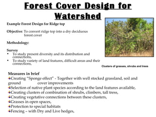
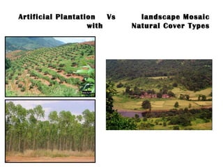
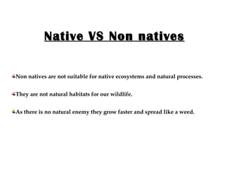
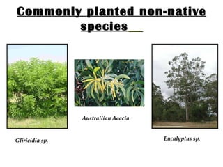
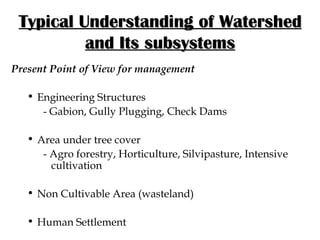
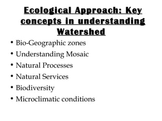
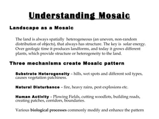
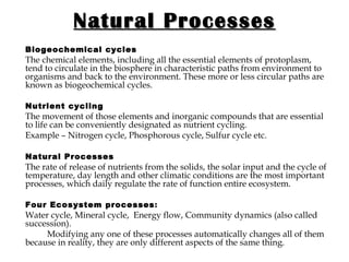
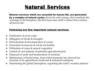
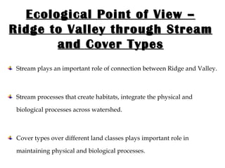
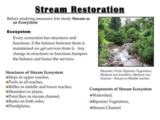
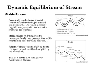
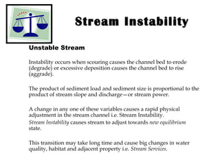
Integrating Ecological Approach in Watershed Management
About the Presentation The objective of this PPT is to explain the significance of ecological approach in present watershed development. It starts with discussing the salient features of the present watershed development model and explains the difference in ecological planning and management for the same. At the end two management alternatives are presented where detailed explanation of ecological restoration of streams and vegetation cover design is given.
Present Watershed Development   Salient Features Watershed and its subsystems Core Objectives Approach Soil Conservation Measures Measures for Water Harvesting in Stream
Typical Understanding of Watershed and Its subsystems Present Point of View for management Engineering Structures - Gabion, Gully Plugging, Check Dams Area under tree cover - Agro forestry, Horticulture, Silvipasture, Intensive    cultivation Non Cultivable Area (wasteland)  Human Settlement
Ecological Approach: Key concepts in understanding Watershed   Bio-Geographic zones Understanding Mosaic  Natural Processes Natural Services  Biodiversity  Microclimatic conditions
Understanding Mosaic Landscape as a Mosaic The land is always spatially  heterogeneous (an uneven, non-random distribution of objects), that always has structure. The key is  solar energy. Over geologic time it produces landforms, and today it grows different plants, which provide structure or heterogeneity to the land. Three mechanisms create Mosaic pattern Substrate Heterogeneity  – hills, wet spots and different soil types, causes vegetation patchiness.  Natural Disturbance  – fire, heavy rains, pest explosions etc. Human Activity  – Plowing Fields, cutting woodlots, building roads, creating patches, corridors, boundaries. Various  biological processes  commonly modify and enhance the pattern .
Natural Processes Biogeochemical cycles The chemical elements, including all the essential elements of protoplasm, tend to circulate in the biosphere in characteristic paths from environment to organisms and back to the environment. These more or less circular paths are known as biogeochemical cycles. Nutrient cycling The movement of those elements and inorganic compounds that are essential to life can be conveniently designated as nutrient cycling. Example – Nitrogen cycle, Phosphorous cycle, Sulfur cycle etc. Natural Processes   The rate of release of nutrients from the solids, the solar input and the cycle of temperature, day length and other climatic conditions are the most important processes, which daily regulate the rate of function entire ecosystem.  Four Ecosystem processes :  Water cycle, Mineral cycle,   Energy flow, Community dynamics (also called succession).   Modifying any one of these processes automatically changes all of them because in reality, they are only different aspects of the same thing.
Natural Services Natures services which are essential for human life, are generated by a complex of natural cycles   driven by solar energy, that constitute the workings of the biosphere, the thin layer near earth’s surface that contains all known life.   Following are few important natural services  Purification of air & water Mitigation of floods & droughts Detoxification & decomposition of wastes Generation & renewal of soil & soil fertility Pollination of crops & natural vegetation Control of vast majority of potential agricultural pests Dispersal of seeds and translocation of nutrients Maintenance of biodiversity, from which humanity has derived key elements of its agricultural, medicinal & industrial enterprise Maintaining the global atmosphere, regulating the earth’s weather patterns
Bio-Diversity Indian Biodiversity India covers about 2% the land area of the world but possesses more than 8% of world’s Bio-Diversity. High endemism is the character of the Indian Biodiversity. Hence Biodiversity loss is irreversible. Importance As explained earlier together with physical conditions, biodiversity also helps to  define characters of nature’s services . If an area atmosphere, soil and water are polluted, nature’s services will be affected. The existing biodiversity will be an indicator of disturbed condition. The variety of species provides a gigantic gene bank which becomes an unlimited source of food & fiber, medicines, antibiotics, pesticides and raw materials for different industries. Wild genes are much stronger in resisting diseases and can impart this strength to domesticated plants such as crops to make them pest resistant.
Present Threat  :  Ecological knowledge is inadequate  For Biodiversity it is not only the number and variety of species and sub-species of plants and animals, higher and lower but also, includes the variety of habitats & niches available in particular area. Habitat is the address & niches available is the profession of each species. It is extremely difficult to separate out and count each and every habitat and niche as they are connected to each other & to larger divisions like biomes in a maze of linkages.  Hence conservation of Biodiversity through protection and elimination of human impacts, which means a kind of relapse into conditions that existed sometimes in the past. The same can be called  Restoration  of natural processes.
Bio-Geographic zones Biogeography  The study of the patterns of distribution of organisms in space and time is called biogeography.  India – A Tropical Country Characteristics of the Tropics High Temperature Monsoon Acute Water Shortage Fragile Soils – poor moisture retention and organic content High Evaporation Rate High Decomposition Rate
Bio-Geographic zones of Maharashtra – A case study I   Konkan  – Narrow strip between Arabian Sea and Western Ghats (Sahyadri), II Crestline  of Western Ghats (Sahyadri), III Slopes, IV Dry Deciduous Zone  of Marathwada and Khandesh, V Dry evergreen Zone  of Vidarbha
Microclimatic conditions   Microclimates Areas of natural vegetation, such as forests or grasslands, have distinctive climate, which is a modification of the general climate typical of the geographical region in which they are situated. These modifications are the result both of small-scale geographical variation in terrain—slope, aspect, etc. – and of the shading and deflection of wind and rain by the community itself. Such local climates are called Microclimates.  Important factors in development of Microclimates are the extent of penetration into the vegetation of sunlight energy, of heat, and of wind and rain (which cause cooling and control humidity).
Few illustrations South facing slopes in Northern Hemisphere receive more sun than north facing ones, for instance, and thus are warmer and tend to be drier. They are also often more sheltered from the cold North-East winds, and these factors influence the biotic community that develops on them. The vegetation itself greatly influences the climate and community. Tall plants, for instance, provide smaller members of the community with shade and protection from wind and rain. The Microclimate of grassland is very much influenced by the height and density of the vegetation. When the height of the vegetation varies in different seasons, the microhabitats will also vary.  The activities of herbivorous insects such as caterpillars, grasshoppers are very much influenced by   the conditions of humidity and temperature among the grasses on which they feed.
Core Objectives in Present Management Soil Conservation Water Conservation
Present point of view - Ridge to Valley Protect the upper reaches to avoid erosion and reduce runoff Avoid siltation of structures in the middle and lower catchments Ensure the cost effectiveness of structures in the valley Improve over all efficiency of measures
Soil Conservation Present Measures Continuous Contour  Trenches Staggered Contour Trenches Continuous Contour Benches  Contour Farming Present Objectives Reduce Soil erosion Provide vegetation cover Trenches on slopes will accelerate erosion   sources from internet
Soil Conservation- Ecological Point of View   Every landscape has variety of vegetation cover spread all over the landscape through variety of land features right from upper reaches to bottom of any slope for example some where depressions, some where steep and medium slopes, rocky out crops etc.  These cover types have a specific character and role to play with that land feature for example reducing erosion, absorbing rain shocks etc. . Shola Forests in ravines
Cover Type Management- a Missing Component Objectives Maintain an  association between different land features and their vegetation cover over the landscape , so as to maintain the biological and physical processes (erosion etc.) over the landscape.  Significance Contour trenches or benches as a generalized and uniform approach all over the slopes from top to bottom is ecologically incorrect and consideration of physical as well as biological processes according to land classes is   important
Ecological Point of View – Ridge to Valley through Stream and Cover Types Stream plays an important role of connection between Ridge and Valley. Stream processes that create habitats, integrate the physical and biological processes across watershed. Cover types over different land classes plays important role in maintaining physical and biological processes.
Stream Restoration Before studying measures lets study  Stream as an Ecosystem Ecosystem Every ecosystem has structures and functions, if the balance between them is maintained we get services from it.  Any change in structures or functions hampers the balance and hence the services. Meander, Pools, Riparian Vegetation, Medium size boulders, Medium size channel – Stream in Middle reaches  Structures of Stream Ecosystem Steps in upper reaches, Pools in all reaches, Riffles in middle and lower reaches, Meanders in plains,  Point Bars in stream channel, Banks on both sides, Floodplains, Components of Stream Ecosystem Watershed, Riparian Vegetation, Stream Channel
Functions or Processes of Stream Ecosystem Transportation of water from land towards sea, Transportation of sediment load from land towards sea Services from Stream Ecosystem Purification of water, Ground water recharge, Rich soil in floodplains, Habitats and Corridors for aquatic as well as other fauna
Dynamic Equilibrium of Stream   Stable Stream A naturally stable stream channel maintains its dimension, pattern and profile such that the stream does not degrade or aggrades i.e. maintains its  structures and functions . Stable streams migrate across the landscape slowly over geologic time while maintaining their form and function. Naturally stable streams must be able to transport the sediment load supplied by the watershed.  This stable state is called  Dynamic Equilibrium  of Stream. sources from internet   sources from internet
Stream Instability Unstable Stream Instability occurs when scouring causes the channel bed to erode (degrade) or excessive deposition causes the channel bed to rise (aggrade).  The product of sediment load and sediment size is proportional to the product of stream slope and discharge—or stream power.  A change in any one of these variables causes a rapid physical adjustment in the stream channel i.e. Stream Instability. Stream Instability  causes stream to adjust towards  new equilibrium  state. This transition may take long time and cause big changes in water quality, habitat and adjacent property i.e.  Stream Services .
Water Harvesting in Streams Conventional Approach   Present Objectives Reduce velocity of flow Infiltration of water in soil  Present Measures Brushwood checkdam Gully plug Gabion structure Masonary checkdam RCC checkdam Earthen checkdam Underground Bandhara Ill effects Reduction in stream velocity results into stream instability, hence hampering the services . Permanent Dam obstructing the stream flow, Instream cultivation and Loss of riparian vegetation
Ecological Objective   Stream Restoration What is Stream Restoration? Stream restoration  is the  re-establishment  of the general structure, functions and self-sustaining behavior of the stream system that existed prior to disturbance.  It is a  holistic process  that requires an understanding of all physical and biological components of the stream system and its watershed.  Temporary Half moon shaped pool where flow is retained for a while Restoration includes a broad range of measures, including the  removal  of the watershed disturbances that are causing stream instability;  installation  of structures and planting of vegetation to protect streambanks and provide habitat; and then  reshaping  or replacement of unstable stream reaches into appropriately designed functional streams and associated floodplains.
Ecological Measures Methodology  Ecological Surveys, Restoration Measures and Monitoring in three important areas of stream ecosystem i.e. watershed, stream channel and riparian vegetation. Ecological Surveys Surveys are carried out to understand present conditions of stream (stable or unstable) by assessing physical and biological components of stream in above mentioned areas. Riparian Vegetation in good condition on one bank and disturbed on other bank Survey of Riparian Vegetation A survey of riparian vegetation is carried out to study condition of present vegetation over there, its association with the aquatic as well as terrestrial fauna over there. For example it can serve as a breeding habitat, feeding habitat or corridors for all types of faunas etc.
Survey in Watershed Study of variety of vegetation cover spread all over the watershed, through variety of land features right from upper reaches to bottom of any slope, some where depressions, some where steep and medium slopes, rocky out crops, wetlands etc. Survey of Stream Channel This survey is done in three reaches particularly upper (high slope), middle (medium slope), lower (plains)  Highly Eroded Stream Banks Purpose: To assess condition of Stream banks, check whether erosion is taking place and if yes at what rate. To assess condition of stream channel, check whether degradation or aggradations is taking place. To assess human Interferences on stream channel like dams, instream cultivation, degradation or aggradations, use of stream as for waste disposal, pathways for livestock etc.
Restoration Measures In Watershed Natural Cover Type Management, Maintaining Enclosures or protected areas Identifying anchoring places and introducing native species Creating and Maintaining Natural Cover Type over Gullies and Ravines, which plays important role of moisture retention and corridors for fauna. Live Hedges Building Half Moon Shaped Pools In Stream Channel  For Bank and Channel Protection from erosion:  Root wads, Rock Vanes (Single, Cross, J-shaped vanes), Point Bars, Rip-Rap etc. For Habitats creation and Pathways for aquatic fauna: Half moon shaped pools, fish ladders.
Restoration Measures In Riparian Vegetation Protection from cutting and grazing, Plantation of suitable riparian tree species decided from the survey, in areas where stream banks have lost their riparian vegetation, Stream banks where riparian vegetation is lost and sever erosion has taken place, initially plantation of grasses is required and later on plantation of trees,
Ecological Monitoring A naturally stable stream channel maintains its dimension, pattern and profile such that the stream does not degrade or aggrades.  Following are the methods used for measuring dimensions, pattern and profile of stream channel Stream Cross Sectional Profile, Pebble count, Pool to Pool distances,  Riffle to Pool distances,  Riffle to Riffle distances,  Over the years  changes in these measurements  helps in deciding whether the stream is heading toward stability or instability and whether any changes are required in measures taken. Cross Section of Stream
Forest Cover Design for Watershed Before starting the forest cover design lets have a quick look at   Ecological groups of Plants Hydrophytes – Water loving plants Mesophytes – Normal plants - Evergreen, Deciduous forests. Xerophytes –  Drought escaping - ephemerals Drought resisting - succulents Drought enduring - hardy, spiny, thorny.  Halophytes – Waterlogged conditions
Forest Cover Design for Watershed Every watershed is composed of various  land forms or features  from ridge to valley through stream.  We can divide watershed into two areas, Elevated Areas and Plain Areas where we get different land features. For  Elevated Areas  following are the land features Hills, Uplands, Slopes, Wetlands, Rocky Outcrops, Gullies and Ravines, Stream Channels, Difficult Areas Pioneer Plants on Rubble Heap Forest on slopes
Forest Cover Design for Watershed For  Plain Areas  following are the land features Hill base areas and pediments, Flood plain area, Wetlands, Grasslands, Stream course and river basin, Forest Cover Design An association between these land features and naturally occurring flora, resulting into relative fauna over there can be called as  forest cover design . Significance  of forest cover is that they play important role in keeping both the physical and biological processes over landscape intact. Grassland
Forest Cover Design for Watershed Trees –   Wind movement, Rains, cooling structures Tall Trees obstruct the wind movement which results into lesser evaporation loss of nearby water bodies. Tall Trees are also responsible for rains. Presence of good Riparian vegetation results into cooling of water in stream reducing evaporation loss. In Dry season leaf litter of these trees fallen into the stream channel also results into reducing the evaporation loss through soil. Riparian Vegetation Few  Cover Types  and their  Ecological roles Shrubs  –   Faunal diversity Insects  Shrubs provide habitats for lesser fauna like insects etc. Clusters   –  Gene bank Clusters as an association of shrubs, herbs, tall trees, climbers serve as a gene bank over any landscape.
Forest Cover Design for Watershed Example of  cover types in   Semi arid  regions and their  ecological successions  For Ridge top and slopes Dry deciduous type of forest as the climax ecosystem composition- Hardwickia  -  Terminalia – Ixora -  Miliusa Secondary regeneration -  Launnea – Boswellia - Anogeissus Third degree of degradation  Acacia  -  Zizyphus  - Thorny species Fourth degree - Scrub  Gymnosporia  -  Amonii  -  Cissus Lastly grasses like  Heteropogon - Aristida For Riparian  Climax compostion Pongam- Jamum –  Bauhinia semla   Degradation  Terminalia Arjuna  - Pongam –  Madhuca indica   Second degree of degradation  Fluggea - Ehretia
Forest Cover Design for Watershed Example Forest Design for Ridge top Objective : To convert ridge top into a dry deciduous    forest cover  Methodology:   Survey   To study present diversity and its distribution and connections, To study variety of land features, difficult areas and their connections, Clusters of grasses, shrubs and trees Measures in brief Creating “Sponge effect” - Together with well stocked grassland, soil and ground  cover improvements  Selection of native plant species according to the land features available,  Creating clusters of combination of shrubs, climbers, tall tress,  Creating vegetative connections between these clusters, Grasses in open spaces, Protection to special habitats Fencing – with Dry and Live hedges,
Artificial Plantation  Vs  landscape Mosaic with  Natural Cover Types
Native VS Non natives Non natives are not suitable for native ecosystems and natural processes. They are not natural habitats for our wildlife. As there is no natural enemy they grow faster and spread like a weed.
Commonly planted non-native species   Gliricidia sp. Eucalyptus sp. Austrailian Acacia
Thank You!

eco_restoration

  • 1.
    Integrating Ecological Approachin Watershed Management
  • 2.
    About the PresentationThe objective of this PPT is to explain the significance of ecological approach in present watershed development. It starts with discussing the salient features of the present watershed development model and explains the difference in ecological planning and management for the same. At the end two management alternatives are presented where detailed explanation of ecological restoration of streams and vegetation cover design is given.
  • 3.
    Present Watershed Development Salient Features Watershed and its subsystems Core Objectives Approach Soil Conservation Measures Measures for Water Harvesting in Stream
  • 4.
    Typical Understanding ofWatershed and Its subsystems Present Point of View for management Engineering Structures - Gabion, Gully Plugging, Check Dams Area under tree cover - Agro forestry, Horticulture, Silvipasture, Intensive cultivation Non Cultivable Area (wasteland) Human Settlement
  • 5.
    Ecological Approach: Keyconcepts in understanding Watershed Bio-Geographic zones Understanding Mosaic Natural Processes Natural Services Biodiversity Microclimatic conditions
  • 6.
    Understanding Mosaic Landscapeas a Mosaic The land is always spatially heterogeneous (an uneven, non-random distribution of objects), that always has structure. The key is solar energy. Over geologic time it produces landforms, and today it grows different plants, which provide structure or heterogeneity to the land. Three mechanisms create Mosaic pattern Substrate Heterogeneity – hills, wet spots and different soil types, causes vegetation patchiness. Natural Disturbance – fire, heavy rains, pest explosions etc. Human Activity – Plowing Fields, cutting woodlots, building roads, creating patches, corridors, boundaries. Various biological processes commonly modify and enhance the pattern .
  • 7.
    Natural Processes Biogeochemicalcycles The chemical elements, including all the essential elements of protoplasm, tend to circulate in the biosphere in characteristic paths from environment to organisms and back to the environment. These more or less circular paths are known as biogeochemical cycles. Nutrient cycling The movement of those elements and inorganic compounds that are essential to life can be conveniently designated as nutrient cycling. Example – Nitrogen cycle, Phosphorous cycle, Sulfur cycle etc. Natural Processes The rate of release of nutrients from the solids, the solar input and the cycle of temperature, day length and other climatic conditions are the most important processes, which daily regulate the rate of function entire ecosystem. Four Ecosystem processes : Water cycle, Mineral cycle, Energy flow, Community dynamics (also called succession). Modifying any one of these processes automatically changes all of them because in reality, they are only different aspects of the same thing.
  • 8.
    Natural Services Naturesservices which are essential for human life, are generated by a complex of natural cycles driven by solar energy, that constitute the workings of the biosphere, the thin layer near earth’s surface that contains all known life. Following are few important natural services Purification of air & water Mitigation of floods & droughts Detoxification & decomposition of wastes Generation & renewal of soil & soil fertility Pollination of crops & natural vegetation Control of vast majority of potential agricultural pests Dispersal of seeds and translocation of nutrients Maintenance of biodiversity, from which humanity has derived key elements of its agricultural, medicinal & industrial enterprise Maintaining the global atmosphere, regulating the earth’s weather patterns
  • 9.
    Bio-Diversity Indian BiodiversityIndia covers about 2% the land area of the world but possesses more than 8% of world’s Bio-Diversity. High endemism is the character of the Indian Biodiversity. Hence Biodiversity loss is irreversible. Importance As explained earlier together with physical conditions, biodiversity also helps to define characters of nature’s services . If an area atmosphere, soil and water are polluted, nature’s services will be affected. The existing biodiversity will be an indicator of disturbed condition. The variety of species provides a gigantic gene bank which becomes an unlimited source of food & fiber, medicines, antibiotics, pesticides and raw materials for different industries. Wild genes are much stronger in resisting diseases and can impart this strength to domesticated plants such as crops to make them pest resistant.
  • 10.
    Present Threat : Ecological knowledge is inadequate For Biodiversity it is not only the number and variety of species and sub-species of plants and animals, higher and lower but also, includes the variety of habitats & niches available in particular area. Habitat is the address & niches available is the profession of each species. It is extremely difficult to separate out and count each and every habitat and niche as they are connected to each other & to larger divisions like biomes in a maze of linkages. Hence conservation of Biodiversity through protection and elimination of human impacts, which means a kind of relapse into conditions that existed sometimes in the past. The same can be called Restoration of natural processes.
  • 11.
    Bio-Geographic zones Biogeography The study of the patterns of distribution of organisms in space and time is called biogeography. India – A Tropical Country Characteristics of the Tropics High Temperature Monsoon Acute Water Shortage Fragile Soils – poor moisture retention and organic content High Evaporation Rate High Decomposition Rate
  • 12.
    Bio-Geographic zones ofMaharashtra – A case study I Konkan – Narrow strip between Arabian Sea and Western Ghats (Sahyadri), II Crestline of Western Ghats (Sahyadri), III Slopes, IV Dry Deciduous Zone of Marathwada and Khandesh, V Dry evergreen Zone of Vidarbha
  • 13.
    Microclimatic conditions Microclimates Areas of natural vegetation, such as forests or grasslands, have distinctive climate, which is a modification of the general climate typical of the geographical region in which they are situated. These modifications are the result both of small-scale geographical variation in terrain—slope, aspect, etc. – and of the shading and deflection of wind and rain by the community itself. Such local climates are called Microclimates. Important factors in development of Microclimates are the extent of penetration into the vegetation of sunlight energy, of heat, and of wind and rain (which cause cooling and control humidity).
  • 14.
    Few illustrations Southfacing slopes in Northern Hemisphere receive more sun than north facing ones, for instance, and thus are warmer and tend to be drier. They are also often more sheltered from the cold North-East winds, and these factors influence the biotic community that develops on them. The vegetation itself greatly influences the climate and community. Tall plants, for instance, provide smaller members of the community with shade and protection from wind and rain. The Microclimate of grassland is very much influenced by the height and density of the vegetation. When the height of the vegetation varies in different seasons, the microhabitats will also vary. The activities of herbivorous insects such as caterpillars, grasshoppers are very much influenced by the conditions of humidity and temperature among the grasses on which they feed.
  • 15.
    Core Objectives inPresent Management Soil Conservation Water Conservation
  • 16.
    Present point ofview - Ridge to Valley Protect the upper reaches to avoid erosion and reduce runoff Avoid siltation of structures in the middle and lower catchments Ensure the cost effectiveness of structures in the valley Improve over all efficiency of measures
  • 17.
    Soil Conservation PresentMeasures Continuous Contour Trenches Staggered Contour Trenches Continuous Contour Benches Contour Farming Present Objectives Reduce Soil erosion Provide vegetation cover Trenches on slopes will accelerate erosion sources from internet
  • 18.
    Soil Conservation- EcologicalPoint of View Every landscape has variety of vegetation cover spread all over the landscape through variety of land features right from upper reaches to bottom of any slope for example some where depressions, some where steep and medium slopes, rocky out crops etc. These cover types have a specific character and role to play with that land feature for example reducing erosion, absorbing rain shocks etc. . Shola Forests in ravines
  • 19.
    Cover Type Management-a Missing Component Objectives Maintain an association between different land features and their vegetation cover over the landscape , so as to maintain the biological and physical processes (erosion etc.) over the landscape. Significance Contour trenches or benches as a generalized and uniform approach all over the slopes from top to bottom is ecologically incorrect and consideration of physical as well as biological processes according to land classes is important
  • 20.
    Ecological Point ofView – Ridge to Valley through Stream and Cover Types Stream plays an important role of connection between Ridge and Valley. Stream processes that create habitats, integrate the physical and biological processes across watershed. Cover types over different land classes plays important role in maintaining physical and biological processes.
  • 21.
    Stream Restoration Beforestudying measures lets study Stream as an Ecosystem Ecosystem Every ecosystem has structures and functions, if the balance between them is maintained we get services from it. Any change in structures or functions hampers the balance and hence the services. Meander, Pools, Riparian Vegetation, Medium size boulders, Medium size channel – Stream in Middle reaches Structures of Stream Ecosystem Steps in upper reaches, Pools in all reaches, Riffles in middle and lower reaches, Meanders in plains, Point Bars in stream channel, Banks on both sides, Floodplains, Components of Stream Ecosystem Watershed, Riparian Vegetation, Stream Channel
  • 22.
    Functions or Processesof Stream Ecosystem Transportation of water from land towards sea, Transportation of sediment load from land towards sea Services from Stream Ecosystem Purification of water, Ground water recharge, Rich soil in floodplains, Habitats and Corridors for aquatic as well as other fauna
  • 23.
    Dynamic Equilibrium ofStream Stable Stream A naturally stable stream channel maintains its dimension, pattern and profile such that the stream does not degrade or aggrades i.e. maintains its structures and functions . Stable streams migrate across the landscape slowly over geologic time while maintaining their form and function. Naturally stable streams must be able to transport the sediment load supplied by the watershed. This stable state is called Dynamic Equilibrium of Stream. sources from internet sources from internet
  • 24.
    Stream Instability UnstableStream Instability occurs when scouring causes the channel bed to erode (degrade) or excessive deposition causes the channel bed to rise (aggrade). The product of sediment load and sediment size is proportional to the product of stream slope and discharge—or stream power. A change in any one of these variables causes a rapid physical adjustment in the stream channel i.e. Stream Instability. Stream Instability causes stream to adjust towards new equilibrium state. This transition may take long time and cause big changes in water quality, habitat and adjacent property i.e. Stream Services .
  • 25.
    Water Harvesting inStreams Conventional Approach Present Objectives Reduce velocity of flow Infiltration of water in soil Present Measures Brushwood checkdam Gully plug Gabion structure Masonary checkdam RCC checkdam Earthen checkdam Underground Bandhara Ill effects Reduction in stream velocity results into stream instability, hence hampering the services . Permanent Dam obstructing the stream flow, Instream cultivation and Loss of riparian vegetation
  • 26.
    Ecological Objective Stream Restoration What is Stream Restoration? Stream restoration is the re-establishment of the general structure, functions and self-sustaining behavior of the stream system that existed prior to disturbance. It is a holistic process that requires an understanding of all physical and biological components of the stream system and its watershed. Temporary Half moon shaped pool where flow is retained for a while Restoration includes a broad range of measures, including the removal of the watershed disturbances that are causing stream instability; installation of structures and planting of vegetation to protect streambanks and provide habitat; and then reshaping or replacement of unstable stream reaches into appropriately designed functional streams and associated floodplains.
  • 27.
    Ecological Measures Methodology Ecological Surveys, Restoration Measures and Monitoring in three important areas of stream ecosystem i.e. watershed, stream channel and riparian vegetation. Ecological Surveys Surveys are carried out to understand present conditions of stream (stable or unstable) by assessing physical and biological components of stream in above mentioned areas. Riparian Vegetation in good condition on one bank and disturbed on other bank Survey of Riparian Vegetation A survey of riparian vegetation is carried out to study condition of present vegetation over there, its association with the aquatic as well as terrestrial fauna over there. For example it can serve as a breeding habitat, feeding habitat or corridors for all types of faunas etc.
  • 28.
    Survey in WatershedStudy of variety of vegetation cover spread all over the watershed, through variety of land features right from upper reaches to bottom of any slope, some where depressions, some where steep and medium slopes, rocky out crops, wetlands etc. Survey of Stream Channel This survey is done in three reaches particularly upper (high slope), middle (medium slope), lower (plains) Highly Eroded Stream Banks Purpose: To assess condition of Stream banks, check whether erosion is taking place and if yes at what rate. To assess condition of stream channel, check whether degradation or aggradations is taking place. To assess human Interferences on stream channel like dams, instream cultivation, degradation or aggradations, use of stream as for waste disposal, pathways for livestock etc.
  • 29.
    Restoration Measures InWatershed Natural Cover Type Management, Maintaining Enclosures or protected areas Identifying anchoring places and introducing native species Creating and Maintaining Natural Cover Type over Gullies and Ravines, which plays important role of moisture retention and corridors for fauna. Live Hedges Building Half Moon Shaped Pools In Stream Channel For Bank and Channel Protection from erosion: Root wads, Rock Vanes (Single, Cross, J-shaped vanes), Point Bars, Rip-Rap etc. For Habitats creation and Pathways for aquatic fauna: Half moon shaped pools, fish ladders.
  • 30.
    Restoration Measures InRiparian Vegetation Protection from cutting and grazing, Plantation of suitable riparian tree species decided from the survey, in areas where stream banks have lost their riparian vegetation, Stream banks where riparian vegetation is lost and sever erosion has taken place, initially plantation of grasses is required and later on plantation of trees,
  • 31.
    Ecological Monitoring Anaturally stable stream channel maintains its dimension, pattern and profile such that the stream does not degrade or aggrades. Following are the methods used for measuring dimensions, pattern and profile of stream channel Stream Cross Sectional Profile, Pebble count, Pool to Pool distances, Riffle to Pool distances, Riffle to Riffle distances, Over the years changes in these measurements helps in deciding whether the stream is heading toward stability or instability and whether any changes are required in measures taken. Cross Section of Stream
  • 32.
    Forest Cover Designfor Watershed Before starting the forest cover design lets have a quick look at Ecological groups of Plants Hydrophytes – Water loving plants Mesophytes – Normal plants - Evergreen, Deciduous forests. Xerophytes – Drought escaping - ephemerals Drought resisting - succulents Drought enduring - hardy, spiny, thorny. Halophytes – Waterlogged conditions
  • 33.
    Forest Cover Designfor Watershed Every watershed is composed of various land forms or features from ridge to valley through stream. We can divide watershed into two areas, Elevated Areas and Plain Areas where we get different land features. For Elevated Areas following are the land features Hills, Uplands, Slopes, Wetlands, Rocky Outcrops, Gullies and Ravines, Stream Channels, Difficult Areas Pioneer Plants on Rubble Heap Forest on slopes
  • 34.
    Forest Cover Designfor Watershed For Plain Areas following are the land features Hill base areas and pediments, Flood plain area, Wetlands, Grasslands, Stream course and river basin, Forest Cover Design An association between these land features and naturally occurring flora, resulting into relative fauna over there can be called as forest cover design . Significance of forest cover is that they play important role in keeping both the physical and biological processes over landscape intact. Grassland
  • 35.
    Forest Cover Designfor Watershed Trees – Wind movement, Rains, cooling structures Tall Trees obstruct the wind movement which results into lesser evaporation loss of nearby water bodies. Tall Trees are also responsible for rains. Presence of good Riparian vegetation results into cooling of water in stream reducing evaporation loss. In Dry season leaf litter of these trees fallen into the stream channel also results into reducing the evaporation loss through soil. Riparian Vegetation Few Cover Types and their Ecological roles Shrubs – Faunal diversity Insects Shrubs provide habitats for lesser fauna like insects etc. Clusters – Gene bank Clusters as an association of shrubs, herbs, tall trees, climbers serve as a gene bank over any landscape.
  • 36.
    Forest Cover Designfor Watershed Example of cover types in Semi arid regions and their ecological successions For Ridge top and slopes Dry deciduous type of forest as the climax ecosystem composition- Hardwickia - Terminalia – Ixora - Miliusa Secondary regeneration - Launnea – Boswellia - Anogeissus Third degree of degradation Acacia - Zizyphus - Thorny species Fourth degree - Scrub Gymnosporia - Amonii - Cissus Lastly grasses like Heteropogon - Aristida For Riparian Climax compostion Pongam- Jamum – Bauhinia semla Degradation Terminalia Arjuna - Pongam – Madhuca indica Second degree of degradation Fluggea - Ehretia
  • 37.
    Forest Cover Designfor Watershed Example Forest Design for Ridge top Objective : To convert ridge top into a dry deciduous forest cover Methodology: Survey To study present diversity and its distribution and connections, To study variety of land features, difficult areas and their connections, Clusters of grasses, shrubs and trees Measures in brief Creating “Sponge effect” - Together with well stocked grassland, soil and ground cover improvements Selection of native plant species according to the land features available, Creating clusters of combination of shrubs, climbers, tall tress, Creating vegetative connections between these clusters, Grasses in open spaces, Protection to special habitats Fencing – with Dry and Live hedges,
  • 38.
    Artificial Plantation Vs landscape Mosaic with Natural Cover Types
  • 39.
    Native VS Nonnatives Non natives are not suitable for native ecosystems and natural processes. They are not natural habitats for our wildlife. As there is no natural enemy they grow faster and spread like a weed.
  • 40.
    Commonly planted non-nativespecies Gliricidia sp. Eucalyptus sp. Austrailian Acacia
  • 41.