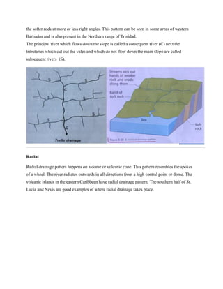
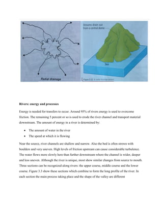
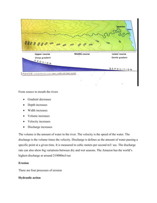
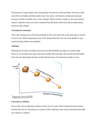
SlideShare a Scribd company logo
CSEC GEOGRAPHY
RIVERS/FLUVIAL MORPHOLOGY
Prepared by Oral Johnson
THE WATER CYCLE
Over 97% of the world’s water is stored in oceans and seas. These water bodies make up about
70% of the surface of the Earth. The remaining stores of water are:
 2.1% as ice and snow ( most of this is Antarctica and Greenland)
 0.6% as ground water (held in rocks)
 0.1% in rivers and lakes
 0.001% held in the atmosphere as water vapor and clouds (water droplets). This amounts
to about 10 days’ supply of average rainfall around the world. If evaporation and
transpiration from the Earth’s surface suddenly stopped the world would run short of
water very quickly!
The three main processes in the water cycle are evaporation, condensation and precipitation.
 Evaporation is the process in which liquid water is changed into water vapor which
is a gas. Evaporation takes place mainly from surface water. Energy is needed for it to
occur. The energy comes from the sun’s heat and from wind. Look how quickly water
evaporates from concrete or tarmac on a very hot day compared with a cooler day!
Evaporation is also faster on a windy day compared with a calm day. Evaporation
from water surfaces on land would not be enough to keep rivers and lakes full and
provide the human population with drinking water. Fortunately, large amounts of
water evaporated from the seas and oceans are carried by air masses onto land where
condensation and precipitation take place.
 Condensation is the process by which water vapour changes into water droplets. It
happens when water vapour is cooled to a level known as the dew point.
Condensation forms cloud and can also occur at the surface as fog.
 Precipitation occurs when water in any form falls from the atmosphere to the surface.
This is mainly as rain, snow, sleet, and hail. Thus, water is constantly recycled
between the sea, air and land.
The Drainage Basin System
When precipitation reaches the surface it can follow a number of different pathways.
A drainage basin is an area of land drained by a river and its tributaries. A drainage basin may
be described as an open system and it forms part of the hydrological or water cycle. If a drainage
basin is viewed as a system then its characteristics are:
 Inputs: how water is introduced into the drainage basin system. This is known as
precipitation.
 Stores: How water is stored or held for a period of time within the drainage basin system-
interception ( by vegetation), soil moisture, surface storage (lakes) and groundwater
 Transfers/flows : a process or flow of water from one place to another in the drainage
basin system- surface run-off/ overland flow, infiltration, percolation, through-flow,
throughfall and groundwater flow
 Outputs: How the water is released either back to the sea or back into the atmosphere-
evapotranspiration and river carrying water to the sea.
Elements of the drainage basin system
Precipitation forms the major input into the system. Precipitation occurs when water in any form
falls from the atmosphere to the surface. This is mainly as rain snow, sleet and hail. When
precipitation reaches the surface it can follow a number a different pathways. A small amount
falls directly into rivers as direct channel precipitation. The rest falls onto vegetation or the
ground. If heavy rain has fallen previously and all the air pockets in the soil (pore spaces) are full
of water, the soil is said to be saturated. Because the soil unable to take in any more water, the
rain flows on the surface under the influence of gravity. This is called surface runoff or
overland flow. Overland flow is common in urban areas where the surface is made up of
impermeable materials such as tarmac and concrete.
Rainwater can be intercepted by vegetation. Interception is the precipitation that is collected and
stored by vegetation. Interception is greatest in summer when trees and plants have most leaves.
Some rainwater is stored on leaves and then evaporated directly into the atmosphere. The
remaining intercepted water either drips to the ground from leaves and branches ( throughfall)
or trickles down tree trunks or plant stems (stemflow) to reach the ground.
The water that reaches the ground may then enter the soil as infiltration. Infiltration is the
passage of water into the soil. The maximum rate at which water can pass through the soil is
called its infiltration capacity and is expressed in mm/hr. Some of the water will flow laterally
through the soil (roughly parallel to the surface) as through flow.
If the soil is not saturated, rainwater will soak into it. If the rock below the soil is permeable
(allows water into it), the water continues to soak down deeper into the rock. This continuous
downward vertical movement of water into the rock is called percolation. The water eventually
comes to an impermeable rock (which does not allow water into it). The underground water level
builds up towards the surface from here to create a groundwater storage. Here all the pore spaces
are filled with water and is sometimes called a zone of saturation. The underground water does
not remain stationary but flows downslope under gravity (laterally). The upper boundary of
underground water or the upper level of the saturated material is known as the water table.
Water contained in rocks is known as ground water. The groundwater may then be slowly
transferred laterally as groundwater flow or base flow. The flow of groundwater is much slower
than runoff with speeds usually measured in centimeters per day, meters per year or centimeters
per year. Rock that holds ground water is known as an aquifer.
Water is lost from the system by evaporation and transpiration. Vegetation takes moisture
through its root system. It loses some of this into the air by transpiration. Surface water is also
lost by evaporation. The combination of the two is known as evapotranspiration. Once in the
river, water flows toward the sea and is lost from the drainage basin system.
Drainage basins
A drainage basin (or catchment area) is the area drained by a river and its tributaries. The
boundary of a drainage basin. The boundary of a drainage basin is called a watershed. This is a
ridge of high land that separates one drainage basin from another. The point where a river begins
is its source. A river reaches the sea at its mouth. A tributary joins the main river at a confluence.
A main river and all its tributaries form a river system. For example, the Mississippi and its
tributaries drain over one-third of the USA. Watershed in the Caribbean islands are typically
‘pear-shaped’: they are broad along the upstream divide and relatively narrow near the sea. In the
volcanic Windward Islands, watershed are steep and deeply dissected.
When small stream begin to flow they act under gravity, following the fastest route downslope.
Along the way water is added to them from tributaries, groundwater flow, throughflow and
overland flow.
The source of a river
The starting point of a river may be:
 An upland lake
 A melting glacier
 A spring in a boggyy upland area where the soil is saturated that recognizable surface
flow begins
 A spring at the boundary between permeable and impermeable rocks
Drainage Density
Some big rivers have a large number of tributaries so that no place in the drainage basin is very
far from a river or stream. Such an area is said to have a high drainage density. Where a main
river has few tributaries the drainage density is low. High drainage densities occur where:
 The bedrock is impermeable
 The soils are easily saturated
 Precipitation is high
 Slopes are steep
 Interception by vegetation is limited
Where drainage density is high, water reaches streams quickly. It moves rapidly through the
basin. Therefore the flood risk is high compared with basins with low drainage densities. In the
Windward Islands, for example, drainage density is relatively high due to the steep slopes and
the volcanic nature of the islands. However, in the coralline/limestone Leeward Islands, slopes
within watersheds tend to be gentle with relatively low drainage densities. In these watersheds on
limestone there is significant percolation into rocks which builds up groundwater reserves.
Drainage patterns
River systems often form a distinct pattern which is due to the structure of the rocks in the
drainage basin. The point at which one river or stream flows into another is known as the
confluence. Three distinctive patterns can be recognized, dendritic, trellis and radial.
Dendritic
This pattern looks like tree branches. This pattern develops in gently sloping basins with fairly
uniform rock type. The tributaries flow into the river at random forming a pattern like the veins
of a leaf. Examples of dendritic drainage are in the Caroni River in Trinidad and the Bruce Vale
river basin in Barbados. This type of drainage pattern is the most common in the Caribbean
region.
Trellis
This drainage pattern has an appearance of a rectangular grid. Rivers and their tributaries flows
almost perpendicular to each other with confluence of almost 90o. Trellis drainage takes place
where there is an alternate band of hard and soft rock at right angles to the main direction of the
slope. The main river has the power to cut though the hard rock while the tributaries cut though
the softer rock at more or less right angles. This pattern can be seen in some areas of western
Barbados and is also present in the Northern range of Trinidad.
The principal river which flows down the slope is called a consequent river (C) next the
tributaries which cut out the vales and which do not flow down the main slope are called
subsequent rivers (S).
Radial
Radial drainage patters happens on a dome or volcanic cone. This pattern resembles the spokes
of a wheel. The river radiates outwards in all directions from a high central point or dome. The
volcanic islands in the eastern Caribbean have radial drainage pattern. The southern half of St.
Lucia and Nevis are good examples of where radial drainage takes place.
Rivers: energy and processes
Energy is needed for transfers to occur. Around 95% of rivers energy is used to overcome
friction. The remaining 5 percent or so is used to erode the river channel and transport material
downstream. The amount of energy in a river is determined by:
 The amount of water in the river
 The speed at which it is flowing
Near the source, river channels are shallow and narrow. Also the bed is often strewn with
boulders and very uneven. High levels of friction upstream can cause considerable turbulence.
The water flows more slowly here than further downstream where the channel is wider, deeper
and less uneven. Although the river is unique, most show similar changes from source to mouth.
Three sections can be recognized along rivers: the upper course, middle course and the lower
course. Figure 3.3 show these sections which combine to form the long profile of the river. In
each section the main process taking place and the shape of the valley are different
From source to mouth the rivers
 Gradient decreases
 Depth increases
 Width increases
 Volume increases
 Velocity increases
 Discharge increases
The volume is the amount of water in the river. The velocity is the speed of the water. The
discharge is the volume times the velocity. Discharge is defines as the amount of water passing a
specific point at a given time. It is measured in cubic meters per second m3/ sec. The discharge
rate can also show big variations between dry and wet seasons. The Amazon has the world’s
highest discharge at around 219000m3/sec
Erosion
There are four processes of erosion
Hydraulic action
The pressure of water breaks away rock particles from the river bed and banks. The force of the
water hits river banks, and then pushes water into cracks. Air becomes compressed, pressure
increases and the riverbank may, in time collapse. Where velocity is high e.g. the outer bend of
meaner, hydraulic action can remove material from the banks which may lead to undercutting
and river bank collapse
Corrasion (or abrasion)
This is the wearing away of the bed and banks by the rivers load. This is the main type of erosion
in most rivers. Where depressions exist in the channel floor the river can cause pebbles to spin
around and turn hollows into potholes.
Attrition:
When pieces of rocks are broken away from the bed and banks the edges are usually sharp.
However, in swirling water rocks and stones collide with each other and with the bed and banks.
Over time the sharp edges become smooth and the pieces of rock become smaller in size.
Corrosion or Solution
Some rocks, such as limestone, dissolve slowly in river water which contains dissolved carbon
dioxide from the air. This process is common where carbonate rocks such as limestone and chalk
are evident in a channel
Most erosion occurs when discharge is high and rivers are said to be in flood. Erosion acts on the
landscape in three ways:
 Near its source a river cuts down into its bed, deepening the valley. This is vertical
erosion
 In the middle and lower courses sideward or lateral erosion is most important. This
widens the valley
 Headward erosion takes place at the source. it causes the valley to grow very slowly
upstream.
Transportation
The load is the total amount of material being carried by the river. There are four processes by
which a river can transport its load: traction, saltation, suspension and solution.
Traction
Traction occurs when the largest cobbles and boulders roll or slide along the bed of the river. The
largest of these may only be moved during times of extreme flood.
Saltation
Saltation occurs when pebbles, sand and gravel are temporarily lifted up by the current and
bounced along the bed in a hopping motion. They are too heavy to carry in suspension
Suspension
Suspension is when material made up of very fine particles such as clay and silt is lifted as the
result of turbulence and transported by the river. Faster-flowing, turbulent rivers carry more
suspended material. The material held in suspension usually forms the greatest part of the total
load; it increases in amount towards the river’s mouth, giving the water its brown or black color.
Solution
Solution is when dissolved material is carried by a river. Water flowing within a river channel
contains acids (e.g. carbonic acid from precipitation). If the bedrock is soluble, like limestone, it
is constantly dissolved in the running water and removed in solution.
Deposition
When the velocity of a river begins to fall, it has less energy and so no longer has the
competence or capacity to carry all its load.
Deposition occurs when:
 Discharge is reduced following a period of low precipitation
 Velocity is lessened on entering the sea or a lake (resulting in a delta)
 The gradient decreases significantly
 The current slows on the inside of a meander
 The river overflow its banks so that the velocity outside the channel is reduced.
When a river loses energy the first part of the load to be deposited is the large, heavy material
known as the bedload. Lighter material is carried further. The gravel, sand and silt deposited is
called alluvium. This is spread over the flood plain. The solution load- the lightest suspended
particles which include clay- is carried out to sea. Some rivers get their name from the colour of
the silt that they carry, for example the Yellow River in China.
THE UPPER COURSE
The many features/landforms in the upper course of a river are:
 V-Shaped Valleys
 Interlocking spurs
 Potholes
 Rapids
 Waterfalls and Gorges
Rapids
Sometimes very thin alternating bands of hard and soft rock cross the course of a river. The
softer rocks wear away/erodes faster than the harder rocks. This is known as differential erosion.
The softer rocks are then on a lower level compared to the harder rocks. This creates an uneven
river bed and the river falling in a series of steps along the bands of the hard rock to form a zone
of turbulent water known as rapids
Potholes
Where the bed is very uneven, pebbles carried by fast, swirling water can become temporarily
trapped by obstacles in the bed. The swirling currents cause the pebbles to rotate in a circular
movement, eroding circular depressions in the bed (abrasion). These are potholes. They general
increase in size only very slowly.
Interlocking Spurs
The river wind its way (meanders) around obstacles of hard rock. Erosion is concentrated on the
outside banks of these small meanders. This eventually creates spurs which alternate on each
side of the river, so they interlock. A spur is a ridge of high land which project towards a river at
right angles, decreasing in height towards the river.
Waterfalls
Waterfalls are the most spectacular feature of the upper course, but they can also be found in the
middle course. This occur when there is a sudden change in the course of the river. This may be
due differences in rock hardness along the valley or for several other reasons:
 A steep drop at the edge of a plateau has been formed by uplift of the land
 A lava flow crosses the path of the river which pours over its edge as a waterfall
Waterfalls can form when the rock is horizontal, vertical or dipping upstream. The lower softer
rock is eroded more quickly causing the hard rock to overhang. The undercutting is caused by
corrosion and hydraulic action, with water swirling around in the plunge pool and spray hitting
the soft rock as the water plunges over the waterfall. The overhang steadily becomes larger until
finally it collapses. The rocks that crash down into the plunge pool are swirled around by the
currents. This increases erosion and makes the plunge pool deeper. The rocks in the plunge pool
are eroded mainly by attrition.
This process, beginning with the collapse of a layer of hard rock, is repeated multiple times. As a
result the waterfall retreats upstream, leaving a steep-sided gorge.
V-shaped valleys
In the upper course much of the rivers energy is needed to overcome friction. The rest is used to
transport the load. The river in this section contains large boulders which can erode the bed
rapidly when the river is in flood. This results in the river cutting downwards into its bed, a
process known as vertical erosion. It forms steep V-shaped valley. Soil and loose rock on the
valley sides are washed down the steep slopes into the river. This adds to the load
THE MIDDLE AND LOWER COURSES
In the middle course of the river profile the gradient is much less than in the upper course. The
volume of the water increases, with more tributaries joining the main river. More water is added
by through flow and, if the rock is permeable, by groundwater flow. Lateral erosion takes over
from vertical erosion as the most important process. Channel is much wider.
The lower course is nearest to the sea. The gradient is gentler. This section is characterized by
an even greater volume of water and higher velocity. Deposition is now much more important
than erosion. Meanders are more pronounced. The valley has the shape of an Open V in cross
section.
River cliffs and Point bars
Meanders occur in the middle course and are the result of erosion and deposition processes
operating in the river. The current is fastest and most powerful on the outside of the meander.
Within the river the fastest current is on the outside of the bend and the slowest current on the
inside of the bend. The concave or outside bend is much deeper so less friction and a higher
velocity.
Erosion is relatively rapid and the outside bank (concave bank) is undercut. Eventually the bank
collapses and retreats, causing the meander to spread across the valley. If the meander has
already reached the side of the valley, erosion on the outside bend may create a very steep slope
or river cliff. The current on the inside (convex bank) of the meander is much slower. As the
river slows it drops some of its load and deposition occurs. This builds up to form a gently
sloping slip-off slope, or point bar. Thus the water is shallow on the inside of the meander and
deep on the outside.
Diagram showing processes operationg on the inside and outside banks of a meander
Diagram showing erosional and depositional actions of a river as it flows around a
meander
Diagram showing a cross section of a meander
Meander migration
Because of the power of lateral erosion in the middle course, meanders slowly change their shape
and position. As they push sideways they widen the valley. But they also move or migrate
downstream. This erodes the interlocking spurs, giving a much more open valley compared with
that in the upper course.
Diagram showing how meanders migrate downstream
Flood plain
A flood plain is the area of almost flat land on both sides of a river. It is formed by the movement
of meanders explained above. Meanders are more pronounced in the lower course. The
floodplain is constantly build up by flooded alluvial deposits. After each flood new layers of
alluvium are formed. This gradually builds up the height of the flood plain. The flood plain is
much more pronounced in the lower course as the river develops a very wide and flat valley
floor.
Diagram below show the flood plain
Levees
When discharge is high the river is able to transport a large amount of material in suspension. At
times of exceptionally high discharge the river will overflow its banks and flood the low-lying
land around it. The sudden increase in friction as the river water surges across the flood plain
reduces velocity and causes the material carried in suspension to be deposited on the flood plain.
The heaviest or coarsest material will be dropped nearest to the river. This can form natural
embankments alongside the river called Levees. Levees are sometimes strengthened by engineers
to control flooding.
The lightest material is carried towards the valley sides. Each time there is a flood a new layer of
alluvium is formed. This gradually builds up the height of the flood plain.
Diagram showing the development of a Levee
Meander necks and Ox-bow lakes
As a river flows from its middle course to its lower course, meanders become even more
pronounced and the valley becomes wider and flatter. Oxbow lakes are shallow, crescent shaped
lakes found on the flood plain and are the remains of a former course of a river.
An oxbow lake develops when a meander becomes so pronounced that only a narrow neck of
land separates the two ends of the meander. Erosion continues to cut into outside bends of the
meander and a meander neck is form. With continuous erosion the meander neck becomes
narrower and narrower. Eventually, when the river is in flood and discharge is high, it may cut
right across the meander neck following a more direct route and shortening its course. For a
while water will flow along both the old meander route and along the new straight course.
However, because the current slows down at the entry and exit points of the meander, deposition
will occur. After a time the meander will be cut off from the new straight course, leaving behind
an Ox-bow lake. When cut-off occurs the only sources of water for the ox-bow lake will be
precipitation and flooding from the river. If evaporation is greater than these additions of water
the ox-bow lake will eventually dry up
Diagram the development of an oxbow lake
Braiding or braided rivers
Braiding is when a river divides for various distances into two or more channels. The channels
are separated by islands of sediment. Braiding occurs when:
 A river carries a very large load, particularly of sand and gravels, in relation to its
velocity.
 The discharge changes rapidly from season to season.
During a dry period or by increase load the river may not be capable of carrying its full load, and
so a great deal of deposition takes place on the bed of the river and the river channels become
choked. This give rises to sandbanks and small islands in the bed. The river is forced to split up
into several channels (known as braided and its way through its own deposits. This is known as a
braided river.
Diagram showing a braided channel
Deltas
Deltas are formed by the deposition of sediments at the mouth of a river as it enters a sea or lake.
Deltas only form under certain conditions and most rivers do not end in a delta.
Large rivers in the lower course have the energy to transport a great deal of material in
suspension. As a river enters the sea its speed of flow is reduced, sometimes very suddenly,
causing deposition. The coarsest materials (like sand) is deposited first because of a greater
weight, while finer material (like clay) are carried out further into the sea. Thus layers of
different sediments are built up on the sea floor until they reach the surface. This happens first at
the landward end of a delta, extending gradually out to sea. This huge platform of river sediment
is called delta.
A delta is therefore an accumulation of sediments at the mouth of the river which has been
formed by deposition of successive layers of sediments. When a river flows into a delta it has to
flow over its own deposit. This causes the river to braid. Each channel in a delta is called a
distributary.
The two main conditions required for deltas to form are:
 The river must have a large amount of sediment
 Coastal currents and waves must not be so strong as to remove sediment faster than the
river can deposit it- if this happens the sediments are spread over a much wider area of
sea floor beyond the mouth of the river.
There are three main types of delta:
 Fan-shaped or arcuate: This is triangular in shape with a slightly rounded outer margin.
The Nile and Yallahs River in Jamaica are examples
 Bird’s foot or digitate: distributaries flanked by sediment extend out to sea like the
claws of a bird’s foot. The Mississippi delta is a good example.
 Estuarine or cuspate: the delta forms an islands in the river’s mouth. The Amazon, and
Essequibo river in Guiana are examples
Major deltas are not common in the Caribbean. This is because it usually takes a large river to
build out into the sea.
Diagram showing the structure of delta
Rivers- CSEC GEOGRAPHY

More Related Content

What's hot

CSEC Geography - Vegetation and Soils
CSEC Geography - Vegetation and SoilsCSEC Geography - Vegetation and Soils
CSEC Geography - Vegetation and Soils
Oral Johnson
 
Human geography- CSEC Geography
Human geography-  CSEC GeographyHuman geography-  CSEC Geography
Human geography- CSEC Geography
Oral Johnson
 
Rivers CSEC Geography
Rivers  CSEC GeographyRivers  CSEC Geography
Rivers CSEC Geography
ry_moore
 
Volcanoes- CSEC GEOGRAPHY
Volcanoes- CSEC GEOGRAPHYVolcanoes- CSEC GEOGRAPHY
Volcanoes- CSEC GEOGRAPHY
Oral Johnson
 
CSEC GEOGRAPHY- Types of rocks
CSEC GEOGRAPHY- Types of rocksCSEC GEOGRAPHY- Types of rocks
CSEC GEOGRAPHY- Types of rocks
Oral Johnson
 
Coral reefs and Mangroves
Coral reefs and MangrovesCoral reefs and Mangroves
Coral reefs and Mangroves
Oral Johnson
 
Simple explanations to CSEC Geography 2016 multiple choice
Simple explanations to CSEC Geography 2016 multiple choiceSimple explanations to CSEC Geography 2016 multiple choice
Simple explanations to CSEC Geography 2016 multiple choice
Oral Johnson
 
Physical and Chemical Weathering
Physical and Chemical WeatheringPhysical and Chemical Weathering
Physical and Chemical Weathering
Oral Johnson
 
Weather and climate- CSEC Geography
Weather and climate- CSEC Geography Weather and climate- CSEC Geography
Weather and climate- CSEC Geography
Oral Johnson
 
CSEC Geography - Global warming
CSEC Geography - Global warmingCSEC Geography - Global warming
CSEC Geography - Global warming
Oral Johnson
 
Simple explanations to CSEC Geography 2013 multiple choice
Simple explanations to CSEC Geography 2013 multiple choiceSimple explanations to CSEC Geography 2013 multiple choice
Simple explanations to CSEC Geography 2013 multiple choice
Oral Johnson
 
Geogaphy sba
Geogaphy sbaGeogaphy sba
Geogaphy sba
Shemar Cunningham
 
CAPE UNIT 1 (ONE) GEOGRAPHY- POPULATION NOTES/SLIDES
CAPE UNIT 1 (ONE) GEOGRAPHY- POPULATION NOTES/SLIDESCAPE UNIT 1 (ONE) GEOGRAPHY- POPULATION NOTES/SLIDES
CAPE UNIT 1 (ONE) GEOGRAPHY- POPULATION NOTES/SLIDES
Oral Johnson
 
Geography sba sample
Geography sba sampleGeography sba sample
Geography sba sample
waseem555
 
CSEC Geography 2015 question 6 sample answers
CSEC Geography 2015 question 6 sample answers CSEC Geography 2015 question 6 sample answers
CSEC Geography 2015 question 6 sample answers
AmandaJ2015
 
CSEC GEOGRAPHY PAPER 1- 2019
CSEC GEOGRAPHY PAPER 1- 2019CSEC GEOGRAPHY PAPER 1- 2019
CSEC GEOGRAPHY PAPER 1- 2019
Oral Johnson
 
Simple explanations with answers to CSEC Geography 2019 multiple choice
Simple explanations with answers to CSEC Geography  2019 multiple choiceSimple explanations with answers to CSEC Geography  2019 multiple choice
Simple explanations with answers to CSEC Geography 2019 multiple choice
Oral Johnson
 
Simple explanations to CSEC Geography 2018 multiple choice
Simple explanations to CSEC Geography 2018 multiple choiceSimple explanations to CSEC Geography 2018 multiple choice
Simple explanations to CSEC Geography 2018 multiple choice
Oral Johnson
 
Simple explanations to CSEC Geography 2010 multiple choice
Simple explanations to CSEC Geography 2010 multiple choiceSimple explanations to CSEC Geography 2010 multiple choice
Simple explanations to CSEC Geography 2010 multiple choice
Oral Johnson
 
Costal landforms
Costal landforms Costal landforms
Costal landforms
AvinashAvi110
 

What's hot (20)

CSEC Geography - Vegetation and Soils
CSEC Geography - Vegetation and SoilsCSEC Geography - Vegetation and Soils
CSEC Geography - Vegetation and Soils
 
Human geography- CSEC Geography
Human geography-  CSEC GeographyHuman geography-  CSEC Geography
Human geography- CSEC Geography
 
Rivers CSEC Geography
Rivers  CSEC GeographyRivers  CSEC Geography
Rivers CSEC Geography
 
Volcanoes- CSEC GEOGRAPHY
Volcanoes- CSEC GEOGRAPHYVolcanoes- CSEC GEOGRAPHY
Volcanoes- CSEC GEOGRAPHY
 
CSEC GEOGRAPHY- Types of rocks
CSEC GEOGRAPHY- Types of rocksCSEC GEOGRAPHY- Types of rocks
CSEC GEOGRAPHY- Types of rocks
 
Coral reefs and Mangroves
Coral reefs and MangrovesCoral reefs and Mangroves
Coral reefs and Mangroves
 
Simple explanations to CSEC Geography 2016 multiple choice
Simple explanations to CSEC Geography 2016 multiple choiceSimple explanations to CSEC Geography 2016 multiple choice
Simple explanations to CSEC Geography 2016 multiple choice
 
Physical and Chemical Weathering
Physical and Chemical WeatheringPhysical and Chemical Weathering
Physical and Chemical Weathering
 
Weather and climate- CSEC Geography
Weather and climate- CSEC Geography Weather and climate- CSEC Geography
Weather and climate- CSEC Geography
 
CSEC Geography - Global warming
CSEC Geography - Global warmingCSEC Geography - Global warming
CSEC Geography - Global warming
 
Simple explanations to CSEC Geography 2013 multiple choice
Simple explanations to CSEC Geography 2013 multiple choiceSimple explanations to CSEC Geography 2013 multiple choice
Simple explanations to CSEC Geography 2013 multiple choice
 
Geogaphy sba
Geogaphy sbaGeogaphy sba
Geogaphy sba
 
CAPE UNIT 1 (ONE) GEOGRAPHY- POPULATION NOTES/SLIDES
CAPE UNIT 1 (ONE) GEOGRAPHY- POPULATION NOTES/SLIDESCAPE UNIT 1 (ONE) GEOGRAPHY- POPULATION NOTES/SLIDES
CAPE UNIT 1 (ONE) GEOGRAPHY- POPULATION NOTES/SLIDES
 
Geography sba sample
Geography sba sampleGeography sba sample
Geography sba sample
 
CSEC Geography 2015 question 6 sample answers
CSEC Geography 2015 question 6 sample answers CSEC Geography 2015 question 6 sample answers
CSEC Geography 2015 question 6 sample answers
 
CSEC GEOGRAPHY PAPER 1- 2019
CSEC GEOGRAPHY PAPER 1- 2019CSEC GEOGRAPHY PAPER 1- 2019
CSEC GEOGRAPHY PAPER 1- 2019
 
Simple explanations with answers to CSEC Geography 2019 multiple choice
Simple explanations with answers to CSEC Geography  2019 multiple choiceSimple explanations with answers to CSEC Geography  2019 multiple choice
Simple explanations with answers to CSEC Geography 2019 multiple choice
 
Simple explanations to CSEC Geography 2018 multiple choice
Simple explanations to CSEC Geography 2018 multiple choiceSimple explanations to CSEC Geography 2018 multiple choice
Simple explanations to CSEC Geography 2018 multiple choice
 
Simple explanations to CSEC Geography 2010 multiple choice
Simple explanations to CSEC Geography 2010 multiple choiceSimple explanations to CSEC Geography 2010 multiple choice
Simple explanations to CSEC Geography 2010 multiple choice
 
Costal landforms
Costal landforms Costal landforms
Costal landforms
 

Similar to Rivers- CSEC GEOGRAPHY

The Hydrological Cycle
The Hydrological CycleThe Hydrological Cycle
The Hydrological Cycle
James Foster
 
6th Grade Chapter 16- water cycle
6th Grade  Chapter 16- water cycle6th Grade  Chapter 16- water cycle
6th Grade Chapter 16- water cycleSteven_iannuccilli
 
Fluvial Process And Related Land Forms
Fluvial Process And Related Land Forms Fluvial Process And Related Land Forms
Fluvial Process And Related Land Forms sileshi
 
Water cycle
Water cycle Water cycle
Water cycle
tishalizatomy
 
GEOGRAPHY YEAR 10: RIVER FEATURES
GEOGRAPHY YEAR 10: RIVER FEATURESGEOGRAPHY YEAR 10: RIVER FEATURES
GEOGRAPHY YEAR 10: RIVER FEATURES
George Dumitrache
 
Geography AS Level full revision notes
Geography AS Level full revision notesGeography AS Level full revision notes
Geography AS Level full revision notes
Brittany Farrant
 
Water Cycle Presentation
Water Cycle PresentationWater Cycle Presentation
Water Cycle Presentationkramerk7
 
What is the river discharge and what factors
What is the river discharge and what factorsWhat is the river discharge and what factors
What is the river discharge and what factors
Mischa Knight
 
Unit 7 ch 11 s1 water resources
Unit 7 ch 11 s1  water resourcesUnit 7 ch 11 s1  water resources
Unit 7 ch 11 s1 water resourceswja10255
 
Hydrosphere notes
Hydrosphere notesHydrosphere notes
Hydrosphere notes
NeilfieOrit2
 
Eath sci (compuesto, dimabayao)
Eath sci (compuesto, dimabayao)Eath sci (compuesto, dimabayao)
Eath sci (compuesto, dimabayao)
nicoledimabayao
 
Unsuccessfulwell Perchedwater table successful wellSpring.docx
Unsuccessfulwell Perchedwater table successful wellSpring.docxUnsuccessfulwell Perchedwater table successful wellSpring.docx
Unsuccessfulwell Perchedwater table successful wellSpring.docx
dickonsondorris
 
Ct 301 hydrology 5th
Ct 301 hydrology 5thCt 301 hydrology 5th
Ct 301 hydrology 5th
EngrHayatHussain
 
Processes of River
Processes of RiverProcesses of River
Processes of River
NavjeetSingh74
 

Similar to Rivers- CSEC GEOGRAPHY (20)

The Hydrological Cycle
The Hydrological CycleThe Hydrological Cycle
The Hydrological Cycle
 
Fresh water
Fresh waterFresh water
Fresh water
 
6th Grade Chapter 16- water cycle
6th Grade  Chapter 16- water cycle6th Grade  Chapter 16- water cycle
6th Grade Chapter 16- water cycle
 
Fluvial Process And Related Land Forms
Fluvial Process And Related Land Forms Fluvial Process And Related Land Forms
Fluvial Process And Related Land Forms
 
Water cycle
Water cycle Water cycle
Water cycle
 
GEOGRAPHY YEAR 10: RIVER FEATURES
GEOGRAPHY YEAR 10: RIVER FEATURESGEOGRAPHY YEAR 10: RIVER FEATURES
GEOGRAPHY YEAR 10: RIVER FEATURES
 
Geography AS Level full revision notes
Geography AS Level full revision notesGeography AS Level full revision notes
Geography AS Level full revision notes
 
Hydrology
HydrologyHydrology
Hydrology
 
Water Cycle Presentation
Water Cycle PresentationWater Cycle Presentation
Water Cycle Presentation
 
What is the river discharge and what factors
What is the river discharge and what factorsWhat is the river discharge and what factors
What is the river discharge and what factors
 
Unit 7 ch 11 s1 water resources
Unit 7 ch 11 s1  water resourcesUnit 7 ch 11 s1  water resources
Unit 7 ch 11 s1 water resources
 
Hydrosphere notes
Hydrosphere notesHydrosphere notes
Hydrosphere notes
 
Chapter nine
Chapter nineChapter nine
Chapter nine
 
Eath sci (compuesto, dimabayao)
Eath sci (compuesto, dimabayao)Eath sci (compuesto, dimabayao)
Eath sci (compuesto, dimabayao)
 
The Hydrologic Cycle
The Hydrologic CycleThe Hydrologic Cycle
The Hydrologic Cycle
 
Unsuccessfulwell Perchedwater table successful wellSpring.docx
Unsuccessfulwell Perchedwater table successful wellSpring.docxUnsuccessfulwell Perchedwater table successful wellSpring.docx
Unsuccessfulwell Perchedwater table successful wellSpring.docx
 
Rivers
RiversRivers
Rivers
 
Ct 301 hydrology 5th
Ct 301 hydrology 5thCt 301 hydrology 5th
Ct 301 hydrology 5th
 
Chapter 9- water erosion
Chapter 9- water erosionChapter 9- water erosion
Chapter 9- water erosion
 
Processes of River
Processes of RiverProcesses of River
Processes of River
 

More from Oral Johnson

Simple explanations to csec geography 2015 multiple choice
Simple explanations to csec geography 2015 multiple choiceSimple explanations to csec geography 2015 multiple choice
Simple explanations to csec geography 2015 multiple choice
Oral Johnson
 
Simple explanations to CSEC geography 2012 multiple choice
Simple explanations to CSEC geography 2012 multiple choiceSimple explanations to CSEC geography 2012 multiple choice
Simple explanations to CSEC geography 2012 multiple choice
Oral Johnson
 
CAPE GEOGRAPHY UNIT 1 PAST PAPER - 2018
CAPE GEOGRAPHY UNIT 1 PAST PAPER - 2018CAPE GEOGRAPHY UNIT 1 PAST PAPER - 2018
CAPE GEOGRAPHY UNIT 1 PAST PAPER - 2018
Oral Johnson
 
CAPE GEOGRAPHY UNIT 1 PAST PAPER - 2018
CAPE GEOGRAPHY UNIT 1 PAST PAPER - 2018CAPE GEOGRAPHY UNIT 1 PAST PAPER - 2018
CAPE GEOGRAPHY UNIT 1 PAST PAPER - 2018
Oral Johnson
 
CAPE GEOGRAPHY UNIT 1 PAST PAPER - 2017
CAPE GEOGRAPHY UNIT 1 PAST PAPER - 2017CAPE GEOGRAPHY UNIT 1 PAST PAPER - 2017
CAPE GEOGRAPHY UNIT 1 PAST PAPER - 2017
Oral Johnson
 
Simple explanations to CSEC Geography 2017 multiple choice
Simple explanations to CSEC Geography 2017 multiple choiceSimple explanations to CSEC Geography 2017 multiple choice
Simple explanations to CSEC Geography 2017 multiple choice
Oral Johnson
 
Simple explanations to Csec Geography 2014 multiple choice
Simple explanations to Csec Geography 2014 multiple choiceSimple explanations to Csec Geography 2014 multiple choice
Simple explanations to Csec Geography 2014 multiple choice
Oral Johnson
 
Simple explanations to CSEC geography 2011 multiple choice
Simple explanations to CSEC geography 2011 multiple choiceSimple explanations to CSEC geography 2011 multiple choice
Simple explanations to CSEC geography 2011 multiple choice
Oral Johnson
 
Cape GEOGRAPHY UNIT 2 - MODULE 2 - TOURISM
Cape GEOGRAPHY UNIT 2 - MODULE 2 - TOURISMCape GEOGRAPHY UNIT 2 - MODULE 2 - TOURISM
Cape GEOGRAPHY UNIT 2 - MODULE 2 - TOURISM
Oral Johnson
 
Practice multiple choice past paper for CAPE UNIT 1 Geography-2011
Practice multiple choice past paper for CAPE UNIT 1 Geography-2011Practice multiple choice past paper for CAPE UNIT 1 Geography-2011
Practice multiple choice past paper for CAPE UNIT 1 Geography-2011
Oral Johnson
 
Practice multiple choice past paper for CAPE UNIT 1 Geography-2010
Practice multiple choice past paper for CAPE UNIT 1 Geography-2010Practice multiple choice past paper for CAPE UNIT 1 Geography-2010
Practice multiple choice past paper for CAPE UNIT 1 Geography-2010
Oral Johnson
 
Practice multiple choice past paper for CAPE UNIT 1 Geography
Practice multiple choice past paper for CAPE UNIT 1 GeographyPractice multiple choice past paper for CAPE UNIT 1 Geography
Practice multiple choice past paper for CAPE UNIT 1 Geography
Oral Johnson
 
Practice multiple choice past paper for CAPE UNIT 1 Geography-2013
Practice multiple choice past paper for CAPE UNIT 1 Geography-2013Practice multiple choice past paper for CAPE UNIT 1 Geography-2013
Practice multiple choice past paper for CAPE UNIT 1 Geography-2013
Oral Johnson
 
CAPE UNIT 2 GEOGRAPHY PAST PAPER- PAPER 1-MULTIPLE CHOICE-2010
CAPE UNIT 2 GEOGRAPHY PAST PAPER- PAPER 1-MULTIPLE CHOICE-2010CAPE UNIT 2 GEOGRAPHY PAST PAPER- PAPER 1-MULTIPLE CHOICE-2010
CAPE UNIT 2 GEOGRAPHY PAST PAPER- PAPER 1-MULTIPLE CHOICE-2010
Oral Johnson
 
CAPE UNIT 2 GEOGRAPHY PAST PAPER- PAPER 1-MULTIPLE CHOICE-2009
CAPE UNIT 2 GEOGRAPHY PAST PAPER- PAPER 1-MULTIPLE CHOICE-2009CAPE UNIT 2 GEOGRAPHY PAST PAPER- PAPER 1-MULTIPLE CHOICE-2009
CAPE UNIT 2 GEOGRAPHY PAST PAPER- PAPER 1-MULTIPLE CHOICE-2009
Oral Johnson
 
CAPE UNIT 2 GEOGRAPHY PAST PAPER- PAPER 1-MULTIPLE CHOICE-2013
CAPE UNIT 2 GEOGRAPHY PAST PAPER- PAPER 1-MULTIPLE CHOICE-2013CAPE UNIT 2 GEOGRAPHY PAST PAPER- PAPER 1-MULTIPLE CHOICE-2013
CAPE UNIT 2 GEOGRAPHY PAST PAPER- PAPER 1-MULTIPLE CHOICE-2013
Oral Johnson
 
CAPE UNIT 2 GEOGRAPHY PAST PAPER- PAPER 1-MULTIPLE CHOICE-2011
CAPE UNIT 2 GEOGRAPHY PAST PAPER- PAPER 1-MULTIPLE CHOICE-2011CAPE UNIT 2 GEOGRAPHY PAST PAPER- PAPER 1-MULTIPLE CHOICE-2011
CAPE UNIT 2 GEOGRAPHY PAST PAPER- PAPER 1-MULTIPLE CHOICE-2011
Oral Johnson
 
CAPE GEOGRAPHY UNIT 1 PAST PAPER-PAPER 2- 2005
CAPE GEOGRAPHY UNIT 1 PAST PAPER-PAPER 2- 2005CAPE GEOGRAPHY UNIT 1 PAST PAPER-PAPER 2- 2005
CAPE GEOGRAPHY UNIT 1 PAST PAPER-PAPER 2- 2005
Oral Johnson
 
CAPE GEOGRAPHY UNIT 1 PAST PAPER-PAPER 2- 2006
CAPE GEOGRAPHY UNIT 1 PAST PAPER-PAPER 2- 2006CAPE GEOGRAPHY UNIT 1 PAST PAPER-PAPER 2- 2006
CAPE GEOGRAPHY UNIT 1 PAST PAPER-PAPER 2- 2006
Oral Johnson
 
CAPE GEOGRAPHY UNIT 1 PAST PAPER-PAPER 2- 2008
CAPE GEOGRAPHY UNIT 1 PAST PAPER-PAPER 2- 2008CAPE GEOGRAPHY UNIT 1 PAST PAPER-PAPER 2- 2008
CAPE GEOGRAPHY UNIT 1 PAST PAPER-PAPER 2- 2008
Oral Johnson
 

More from Oral Johnson (20)

Simple explanations to csec geography 2015 multiple choice
Simple explanations to csec geography 2015 multiple choiceSimple explanations to csec geography 2015 multiple choice
Simple explanations to csec geography 2015 multiple choice
 
Simple explanations to CSEC geography 2012 multiple choice
Simple explanations to CSEC geography 2012 multiple choiceSimple explanations to CSEC geography 2012 multiple choice
Simple explanations to CSEC geography 2012 multiple choice
 
CAPE GEOGRAPHY UNIT 1 PAST PAPER - 2018
CAPE GEOGRAPHY UNIT 1 PAST PAPER - 2018CAPE GEOGRAPHY UNIT 1 PAST PAPER - 2018
CAPE GEOGRAPHY UNIT 1 PAST PAPER - 2018
 
CAPE GEOGRAPHY UNIT 1 PAST PAPER - 2018
CAPE GEOGRAPHY UNIT 1 PAST PAPER - 2018CAPE GEOGRAPHY UNIT 1 PAST PAPER - 2018
CAPE GEOGRAPHY UNIT 1 PAST PAPER - 2018
 
CAPE GEOGRAPHY UNIT 1 PAST PAPER - 2017
CAPE GEOGRAPHY UNIT 1 PAST PAPER - 2017CAPE GEOGRAPHY UNIT 1 PAST PAPER - 2017
CAPE GEOGRAPHY UNIT 1 PAST PAPER - 2017
 
Simple explanations to CSEC Geography 2017 multiple choice
Simple explanations to CSEC Geography 2017 multiple choiceSimple explanations to CSEC Geography 2017 multiple choice
Simple explanations to CSEC Geography 2017 multiple choice
 
Simple explanations to Csec Geography 2014 multiple choice
Simple explanations to Csec Geography 2014 multiple choiceSimple explanations to Csec Geography 2014 multiple choice
Simple explanations to Csec Geography 2014 multiple choice
 
Simple explanations to CSEC geography 2011 multiple choice
Simple explanations to CSEC geography 2011 multiple choiceSimple explanations to CSEC geography 2011 multiple choice
Simple explanations to CSEC geography 2011 multiple choice
 
Cape GEOGRAPHY UNIT 2 - MODULE 2 - TOURISM
Cape GEOGRAPHY UNIT 2 - MODULE 2 - TOURISMCape GEOGRAPHY UNIT 2 - MODULE 2 - TOURISM
Cape GEOGRAPHY UNIT 2 - MODULE 2 - TOURISM
 
Practice multiple choice past paper for CAPE UNIT 1 Geography-2011
Practice multiple choice past paper for CAPE UNIT 1 Geography-2011Practice multiple choice past paper for CAPE UNIT 1 Geography-2011
Practice multiple choice past paper for CAPE UNIT 1 Geography-2011
 
Practice multiple choice past paper for CAPE UNIT 1 Geography-2010
Practice multiple choice past paper for CAPE UNIT 1 Geography-2010Practice multiple choice past paper for CAPE UNIT 1 Geography-2010
Practice multiple choice past paper for CAPE UNIT 1 Geography-2010
 
Practice multiple choice past paper for CAPE UNIT 1 Geography
Practice multiple choice past paper for CAPE UNIT 1 GeographyPractice multiple choice past paper for CAPE UNIT 1 Geography
Practice multiple choice past paper for CAPE UNIT 1 Geography
 
Practice multiple choice past paper for CAPE UNIT 1 Geography-2013
Practice multiple choice past paper for CAPE UNIT 1 Geography-2013Practice multiple choice past paper for CAPE UNIT 1 Geography-2013
Practice multiple choice past paper for CAPE UNIT 1 Geography-2013
 
CAPE UNIT 2 GEOGRAPHY PAST PAPER- PAPER 1-MULTIPLE CHOICE-2010
CAPE UNIT 2 GEOGRAPHY PAST PAPER- PAPER 1-MULTIPLE CHOICE-2010CAPE UNIT 2 GEOGRAPHY PAST PAPER- PAPER 1-MULTIPLE CHOICE-2010
CAPE UNIT 2 GEOGRAPHY PAST PAPER- PAPER 1-MULTIPLE CHOICE-2010
 
CAPE UNIT 2 GEOGRAPHY PAST PAPER- PAPER 1-MULTIPLE CHOICE-2009
CAPE UNIT 2 GEOGRAPHY PAST PAPER- PAPER 1-MULTIPLE CHOICE-2009CAPE UNIT 2 GEOGRAPHY PAST PAPER- PAPER 1-MULTIPLE CHOICE-2009
CAPE UNIT 2 GEOGRAPHY PAST PAPER- PAPER 1-MULTIPLE CHOICE-2009
 
CAPE UNIT 2 GEOGRAPHY PAST PAPER- PAPER 1-MULTIPLE CHOICE-2013
CAPE UNIT 2 GEOGRAPHY PAST PAPER- PAPER 1-MULTIPLE CHOICE-2013CAPE UNIT 2 GEOGRAPHY PAST PAPER- PAPER 1-MULTIPLE CHOICE-2013
CAPE UNIT 2 GEOGRAPHY PAST PAPER- PAPER 1-MULTIPLE CHOICE-2013
 
CAPE UNIT 2 GEOGRAPHY PAST PAPER- PAPER 1-MULTIPLE CHOICE-2011
CAPE UNIT 2 GEOGRAPHY PAST PAPER- PAPER 1-MULTIPLE CHOICE-2011CAPE UNIT 2 GEOGRAPHY PAST PAPER- PAPER 1-MULTIPLE CHOICE-2011
CAPE UNIT 2 GEOGRAPHY PAST PAPER- PAPER 1-MULTIPLE CHOICE-2011
 
CAPE GEOGRAPHY UNIT 1 PAST PAPER-PAPER 2- 2005
CAPE GEOGRAPHY UNIT 1 PAST PAPER-PAPER 2- 2005CAPE GEOGRAPHY UNIT 1 PAST PAPER-PAPER 2- 2005
CAPE GEOGRAPHY UNIT 1 PAST PAPER-PAPER 2- 2005
 
CAPE GEOGRAPHY UNIT 1 PAST PAPER-PAPER 2- 2006
CAPE GEOGRAPHY UNIT 1 PAST PAPER-PAPER 2- 2006CAPE GEOGRAPHY UNIT 1 PAST PAPER-PAPER 2- 2006
CAPE GEOGRAPHY UNIT 1 PAST PAPER-PAPER 2- 2006
 
CAPE GEOGRAPHY UNIT 1 PAST PAPER-PAPER 2- 2008
CAPE GEOGRAPHY UNIT 1 PAST PAPER-PAPER 2- 2008CAPE GEOGRAPHY UNIT 1 PAST PAPER-PAPER 2- 2008
CAPE GEOGRAPHY UNIT 1 PAST PAPER-PAPER 2- 2008
 

Recently uploaded

How to Add Chatter in the odoo 17 ERP Module
How to Add Chatter in the odoo 17 ERP ModuleHow to Add Chatter in the odoo 17 ERP Module
How to Add Chatter in the odoo 17 ERP Module
Celine George
 
The Diamonds of 2023-2024 in the IGRA collection
The Diamonds of 2023-2024 in the IGRA collectionThe Diamonds of 2023-2024 in the IGRA collection
The Diamonds of 2023-2024 in the IGRA collection
Israel Genealogy Research Association
 
BÀI TẬP BỔ TRỢ TIẾNG ANH GLOBAL SUCCESS LỚP 3 - CẢ NĂM (CÓ FILE NGHE VÀ ĐÁP Á...
BÀI TẬP BỔ TRỢ TIẾNG ANH GLOBAL SUCCESS LỚP 3 - CẢ NĂM (CÓ FILE NGHE VÀ ĐÁP Á...BÀI TẬP BỔ TRỢ TIẾNG ANH GLOBAL SUCCESS LỚP 3 - CẢ NĂM (CÓ FILE NGHE VÀ ĐÁP Á...
BÀI TẬP BỔ TRỢ TIẾNG ANH GLOBAL SUCCESS LỚP 3 - CẢ NĂM (CÓ FILE NGHE VÀ ĐÁP Á...
Nguyen Thanh Tu Collection
 
Chapter 4 - Islamic Financial Institutions in Malaysia.pptx
Chapter 4 - Islamic Financial Institutions in Malaysia.pptxChapter 4 - Islamic Financial Institutions in Malaysia.pptx
Chapter 4 - Islamic Financial Institutions in Malaysia.pptx
Mohd Adib Abd Muin, Senior Lecturer at Universiti Utara Malaysia
 
S1-Introduction-Biopesticides in ICM.pptx
S1-Introduction-Biopesticides in ICM.pptxS1-Introduction-Biopesticides in ICM.pptx
S1-Introduction-Biopesticides in ICM.pptx
tarandeep35
 
A Survey of Techniques for Maximizing LLM Performance.pptx
A Survey of Techniques for Maximizing LLM Performance.pptxA Survey of Techniques for Maximizing LLM Performance.pptx
A Survey of Techniques for Maximizing LLM Performance.pptx
thanhdowork
 
Azure Interview Questions and Answers PDF By ScholarHat
Azure Interview Questions and Answers PDF By ScholarHatAzure Interview Questions and Answers PDF By ScholarHat
Azure Interview Questions and Answers PDF By ScholarHat
Scholarhat
 
Group Presentation 2 Economics.Ariana Buscigliopptx
Group Presentation 2 Economics.Ariana BuscigliopptxGroup Presentation 2 Economics.Ariana Buscigliopptx
Group Presentation 2 Economics.Ariana Buscigliopptx
ArianaBusciglio
 
Natural birth techniques - Mrs.Akanksha Trivedi Rama University
Natural birth techniques - Mrs.Akanksha Trivedi Rama UniversityNatural birth techniques - Mrs.Akanksha Trivedi Rama University
Natural birth techniques - Mrs.Akanksha Trivedi Rama University
Akanksha trivedi rama nursing college kanpur.
 
Biological Screening of Herbal Drugs in detailed.
Biological Screening of Herbal Drugs in detailed.Biological Screening of Herbal Drugs in detailed.
Biological Screening of Herbal Drugs in detailed.
Ashokrao Mane college of Pharmacy Peth-Vadgaon
 
Introduction to AI for Nonprofits with Tapp Network
Introduction to AI for Nonprofits with Tapp NetworkIntroduction to AI for Nonprofits with Tapp Network
Introduction to AI for Nonprofits with Tapp Network
TechSoup
 
Lapbook sobre os Regimes Totalitários.pdf
Lapbook sobre os Regimes Totalitários.pdfLapbook sobre os Regimes Totalitários.pdf
Lapbook sobre os Regimes Totalitários.pdf
Jean Carlos Nunes Paixão
 
Top five deadliest dog breeds in America
Top five deadliest dog breeds in AmericaTop five deadliest dog breeds in America
Top five deadliest dog breeds in America
Bisnar Chase Personal Injury Attorneys
 
Best Digital Marketing Institute In NOIDA
Best Digital Marketing Institute In NOIDABest Digital Marketing Institute In NOIDA
Best Digital Marketing Institute In NOIDA
deeptiverma2406
 
MASS MEDIA STUDIES-835-CLASS XI Resource Material.pdf
MASS MEDIA STUDIES-835-CLASS XI Resource Material.pdfMASS MEDIA STUDIES-835-CLASS XI Resource Material.pdf
MASS MEDIA STUDIES-835-CLASS XI Resource Material.pdf
goswamiyash170123
 
Digital Artefact 1 - Tiny Home Environmental Design
Digital Artefact 1 - Tiny Home Environmental DesignDigital Artefact 1 - Tiny Home Environmental Design
Digital Artefact 1 - Tiny Home Environmental Design
amberjdewit93
 
Aficamten in HCM (SEQUOIA HCM TRIAL 2024)
Aficamten in HCM (SEQUOIA HCM TRIAL 2024)Aficamten in HCM (SEQUOIA HCM TRIAL 2024)
Aficamten in HCM (SEQUOIA HCM TRIAL 2024)
Ashish Kohli
 
2024.06.01 Introducing a competency framework for languag learning materials ...
2024.06.01 Introducing a competency framework for languag learning materials ...2024.06.01 Introducing a competency framework for languag learning materials ...
2024.06.01 Introducing a competency framework for languag learning materials ...
Sandy Millin
 
The basics of sentences session 5pptx.pptx
The basics of sentences session 5pptx.pptxThe basics of sentences session 5pptx.pptx
The basics of sentences session 5pptx.pptx
heathfieldcps1
 
RPMS TEMPLATE FOR SCHOOL YEAR 2023-2024 FOR TEACHER 1 TO TEACHER 3
RPMS TEMPLATE FOR SCHOOL YEAR 2023-2024 FOR TEACHER 1 TO TEACHER 3RPMS TEMPLATE FOR SCHOOL YEAR 2023-2024 FOR TEACHER 1 TO TEACHER 3
RPMS TEMPLATE FOR SCHOOL YEAR 2023-2024 FOR TEACHER 1 TO TEACHER 3
IreneSebastianRueco1
 

Recently uploaded (20)

How to Add Chatter in the odoo 17 ERP Module
How to Add Chatter in the odoo 17 ERP ModuleHow to Add Chatter in the odoo 17 ERP Module
How to Add Chatter in the odoo 17 ERP Module
 
The Diamonds of 2023-2024 in the IGRA collection
The Diamonds of 2023-2024 in the IGRA collectionThe Diamonds of 2023-2024 in the IGRA collection
The Diamonds of 2023-2024 in the IGRA collection
 
BÀI TẬP BỔ TRỢ TIẾNG ANH GLOBAL SUCCESS LỚP 3 - CẢ NĂM (CÓ FILE NGHE VÀ ĐÁP Á...
BÀI TẬP BỔ TRỢ TIẾNG ANH GLOBAL SUCCESS LỚP 3 - CẢ NĂM (CÓ FILE NGHE VÀ ĐÁP Á...BÀI TẬP BỔ TRỢ TIẾNG ANH GLOBAL SUCCESS LỚP 3 - CẢ NĂM (CÓ FILE NGHE VÀ ĐÁP Á...
BÀI TẬP BỔ TRỢ TIẾNG ANH GLOBAL SUCCESS LỚP 3 - CẢ NĂM (CÓ FILE NGHE VÀ ĐÁP Á...
 
Chapter 4 - Islamic Financial Institutions in Malaysia.pptx
Chapter 4 - Islamic Financial Institutions in Malaysia.pptxChapter 4 - Islamic Financial Institutions in Malaysia.pptx
Chapter 4 - Islamic Financial Institutions in Malaysia.pptx
 
S1-Introduction-Biopesticides in ICM.pptx
S1-Introduction-Biopesticides in ICM.pptxS1-Introduction-Biopesticides in ICM.pptx
S1-Introduction-Biopesticides in ICM.pptx
 
A Survey of Techniques for Maximizing LLM Performance.pptx
A Survey of Techniques for Maximizing LLM Performance.pptxA Survey of Techniques for Maximizing LLM Performance.pptx
A Survey of Techniques for Maximizing LLM Performance.pptx
 
Azure Interview Questions and Answers PDF By ScholarHat
Azure Interview Questions and Answers PDF By ScholarHatAzure Interview Questions and Answers PDF By ScholarHat
Azure Interview Questions and Answers PDF By ScholarHat
 
Group Presentation 2 Economics.Ariana Buscigliopptx
Group Presentation 2 Economics.Ariana BuscigliopptxGroup Presentation 2 Economics.Ariana Buscigliopptx
Group Presentation 2 Economics.Ariana Buscigliopptx
 
Natural birth techniques - Mrs.Akanksha Trivedi Rama University
Natural birth techniques - Mrs.Akanksha Trivedi Rama UniversityNatural birth techniques - Mrs.Akanksha Trivedi Rama University
Natural birth techniques - Mrs.Akanksha Trivedi Rama University
 
Biological Screening of Herbal Drugs in detailed.
Biological Screening of Herbal Drugs in detailed.Biological Screening of Herbal Drugs in detailed.
Biological Screening of Herbal Drugs in detailed.
 
Introduction to AI for Nonprofits with Tapp Network
Introduction to AI for Nonprofits with Tapp NetworkIntroduction to AI for Nonprofits with Tapp Network
Introduction to AI for Nonprofits with Tapp Network
 
Lapbook sobre os Regimes Totalitários.pdf
Lapbook sobre os Regimes Totalitários.pdfLapbook sobre os Regimes Totalitários.pdf
Lapbook sobre os Regimes Totalitários.pdf
 
Top five deadliest dog breeds in America
Top five deadliest dog breeds in AmericaTop five deadliest dog breeds in America
Top five deadliest dog breeds in America
 
Best Digital Marketing Institute In NOIDA
Best Digital Marketing Institute In NOIDABest Digital Marketing Institute In NOIDA
Best Digital Marketing Institute In NOIDA
 
MASS MEDIA STUDIES-835-CLASS XI Resource Material.pdf
MASS MEDIA STUDIES-835-CLASS XI Resource Material.pdfMASS MEDIA STUDIES-835-CLASS XI Resource Material.pdf
MASS MEDIA STUDIES-835-CLASS XI Resource Material.pdf
 
Digital Artefact 1 - Tiny Home Environmental Design
Digital Artefact 1 - Tiny Home Environmental DesignDigital Artefact 1 - Tiny Home Environmental Design
Digital Artefact 1 - Tiny Home Environmental Design
 
Aficamten in HCM (SEQUOIA HCM TRIAL 2024)
Aficamten in HCM (SEQUOIA HCM TRIAL 2024)Aficamten in HCM (SEQUOIA HCM TRIAL 2024)
Aficamten in HCM (SEQUOIA HCM TRIAL 2024)
 
2024.06.01 Introducing a competency framework for languag learning materials ...
2024.06.01 Introducing a competency framework for languag learning materials ...2024.06.01 Introducing a competency framework for languag learning materials ...
2024.06.01 Introducing a competency framework for languag learning materials ...
 
The basics of sentences session 5pptx.pptx
The basics of sentences session 5pptx.pptxThe basics of sentences session 5pptx.pptx
The basics of sentences session 5pptx.pptx
 
RPMS TEMPLATE FOR SCHOOL YEAR 2023-2024 FOR TEACHER 1 TO TEACHER 3
RPMS TEMPLATE FOR SCHOOL YEAR 2023-2024 FOR TEACHER 1 TO TEACHER 3RPMS TEMPLATE FOR SCHOOL YEAR 2023-2024 FOR TEACHER 1 TO TEACHER 3
RPMS TEMPLATE FOR SCHOOL YEAR 2023-2024 FOR TEACHER 1 TO TEACHER 3
 

Rivers- CSEC GEOGRAPHY

  • 1. CSEC GEOGRAPHY RIVERS/FLUVIAL MORPHOLOGY Prepared by Oral Johnson THE WATER CYCLE Over 97% of the world’s water is stored in oceans and seas. These water bodies make up about 70% of the surface of the Earth. The remaining stores of water are:  2.1% as ice and snow ( most of this is Antarctica and Greenland)  0.6% as ground water (held in rocks)  0.1% in rivers and lakes  0.001% held in the atmosphere as water vapor and clouds (water droplets). This amounts to about 10 days’ supply of average rainfall around the world. If evaporation and transpiration from the Earth’s surface suddenly stopped the world would run short of water very quickly! The three main processes in the water cycle are evaporation, condensation and precipitation.  Evaporation is the process in which liquid water is changed into water vapor which is a gas. Evaporation takes place mainly from surface water. Energy is needed for it to occur. The energy comes from the sun’s heat and from wind. Look how quickly water evaporates from concrete or tarmac on a very hot day compared with a cooler day! Evaporation is also faster on a windy day compared with a calm day. Evaporation from water surfaces on land would not be enough to keep rivers and lakes full and provide the human population with drinking water. Fortunately, large amounts of water evaporated from the seas and oceans are carried by air masses onto land where condensation and precipitation take place.  Condensation is the process by which water vapour changes into water droplets. It happens when water vapour is cooled to a level known as the dew point. Condensation forms cloud and can also occur at the surface as fog.
  • 2.  Precipitation occurs when water in any form falls from the atmosphere to the surface. This is mainly as rain, snow, sleet, and hail. Thus, water is constantly recycled between the sea, air and land. The Drainage Basin System When precipitation reaches the surface it can follow a number of different pathways.
  • 3. A drainage basin is an area of land drained by a river and its tributaries. A drainage basin may be described as an open system and it forms part of the hydrological or water cycle. If a drainage basin is viewed as a system then its characteristics are:  Inputs: how water is introduced into the drainage basin system. This is known as precipitation.  Stores: How water is stored or held for a period of time within the drainage basin system- interception ( by vegetation), soil moisture, surface storage (lakes) and groundwater  Transfers/flows : a process or flow of water from one place to another in the drainage basin system- surface run-off/ overland flow, infiltration, percolation, through-flow, throughfall and groundwater flow  Outputs: How the water is released either back to the sea or back into the atmosphere- evapotranspiration and river carrying water to the sea. Elements of the drainage basin system
  • 4. Precipitation forms the major input into the system. Precipitation occurs when water in any form falls from the atmosphere to the surface. This is mainly as rain snow, sleet and hail. When precipitation reaches the surface it can follow a number a different pathways. A small amount falls directly into rivers as direct channel precipitation. The rest falls onto vegetation or the ground. If heavy rain has fallen previously and all the air pockets in the soil (pore spaces) are full of water, the soil is said to be saturated. Because the soil unable to take in any more water, the rain flows on the surface under the influence of gravity. This is called surface runoff or overland flow. Overland flow is common in urban areas where the surface is made up of impermeable materials such as tarmac and concrete. Rainwater can be intercepted by vegetation. Interception is the precipitation that is collected and stored by vegetation. Interception is greatest in summer when trees and plants have most leaves. Some rainwater is stored on leaves and then evaporated directly into the atmosphere. The remaining intercepted water either drips to the ground from leaves and branches ( throughfall) or trickles down tree trunks or plant stems (stemflow) to reach the ground. The water that reaches the ground may then enter the soil as infiltration. Infiltration is the passage of water into the soil. The maximum rate at which water can pass through the soil is called its infiltration capacity and is expressed in mm/hr. Some of the water will flow laterally through the soil (roughly parallel to the surface) as through flow. If the soil is not saturated, rainwater will soak into it. If the rock below the soil is permeable (allows water into it), the water continues to soak down deeper into the rock. This continuous downward vertical movement of water into the rock is called percolation. The water eventually comes to an impermeable rock (which does not allow water into it). The underground water level builds up towards the surface from here to create a groundwater storage. Here all the pore spaces are filled with water and is sometimes called a zone of saturation. The underground water does not remain stationary but flows downslope under gravity (laterally). The upper boundary of underground water or the upper level of the saturated material is known as the water table. Water contained in rocks is known as ground water. The groundwater may then be slowly transferred laterally as groundwater flow or base flow. The flow of groundwater is much slower than runoff with speeds usually measured in centimeters per day, meters per year or centimeters per year. Rock that holds ground water is known as an aquifer.
  • 5. Water is lost from the system by evaporation and transpiration. Vegetation takes moisture through its root system. It loses some of this into the air by transpiration. Surface water is also lost by evaporation. The combination of the two is known as evapotranspiration. Once in the river, water flows toward the sea and is lost from the drainage basin system. Drainage basins A drainage basin (or catchment area) is the area drained by a river and its tributaries. The boundary of a drainage basin. The boundary of a drainage basin is called a watershed. This is a ridge of high land that separates one drainage basin from another. The point where a river begins is its source. A river reaches the sea at its mouth. A tributary joins the main river at a confluence. A main river and all its tributaries form a river system. For example, the Mississippi and its tributaries drain over one-third of the USA. Watershed in the Caribbean islands are typically ‘pear-shaped’: they are broad along the upstream divide and relatively narrow near the sea. In the volcanic Windward Islands, watershed are steep and deeply dissected. When small stream begin to flow they act under gravity, following the fastest route downslope. Along the way water is added to them from tributaries, groundwater flow, throughflow and overland flow.
  • 6. The source of a river The starting point of a river may be:  An upland lake
  • 7.  A melting glacier  A spring in a boggyy upland area where the soil is saturated that recognizable surface flow begins  A spring at the boundary between permeable and impermeable rocks Drainage Density Some big rivers have a large number of tributaries so that no place in the drainage basin is very far from a river or stream. Such an area is said to have a high drainage density. Where a main river has few tributaries the drainage density is low. High drainage densities occur where:  The bedrock is impermeable  The soils are easily saturated  Precipitation is high  Slopes are steep  Interception by vegetation is limited Where drainage density is high, water reaches streams quickly. It moves rapidly through the basin. Therefore the flood risk is high compared with basins with low drainage densities. In the Windward Islands, for example, drainage density is relatively high due to the steep slopes and the volcanic nature of the islands. However, in the coralline/limestone Leeward Islands, slopes within watersheds tend to be gentle with relatively low drainage densities. In these watersheds on limestone there is significant percolation into rocks which builds up groundwater reserves.
  • 8. Drainage patterns River systems often form a distinct pattern which is due to the structure of the rocks in the drainage basin. The point at which one river or stream flows into another is known as the confluence. Three distinctive patterns can be recognized, dendritic, trellis and radial. Dendritic This pattern looks like tree branches. This pattern develops in gently sloping basins with fairly uniform rock type. The tributaries flow into the river at random forming a pattern like the veins of a leaf. Examples of dendritic drainage are in the Caroni River in Trinidad and the Bruce Vale river basin in Barbados. This type of drainage pattern is the most common in the Caribbean region. Trellis This drainage pattern has an appearance of a rectangular grid. Rivers and their tributaries flows almost perpendicular to each other with confluence of almost 90o. Trellis drainage takes place where there is an alternate band of hard and soft rock at right angles to the main direction of the slope. The main river has the power to cut though the hard rock while the tributaries cut though
  • 9. the softer rock at more or less right angles. This pattern can be seen in some areas of western Barbados and is also present in the Northern range of Trinidad. The principal river which flows down the slope is called a consequent river (C) next the tributaries which cut out the vales and which do not flow down the main slope are called subsequent rivers (S). Radial Radial drainage patters happens on a dome or volcanic cone. This pattern resembles the spokes of a wheel. The river radiates outwards in all directions from a high central point or dome. The volcanic islands in the eastern Caribbean have radial drainage pattern. The southern half of St. Lucia and Nevis are good examples of where radial drainage takes place.
  • 10. Rivers: energy and processes Energy is needed for transfers to occur. Around 95% of rivers energy is used to overcome friction. The remaining 5 percent or so is used to erode the river channel and transport material downstream. The amount of energy in a river is determined by:  The amount of water in the river  The speed at which it is flowing Near the source, river channels are shallow and narrow. Also the bed is often strewn with boulders and very uneven. High levels of friction upstream can cause considerable turbulence. The water flows more slowly here than further downstream where the channel is wider, deeper and less uneven. Although the river is unique, most show similar changes from source to mouth. Three sections can be recognized along rivers: the upper course, middle course and the lower course. Figure 3.3 show these sections which combine to form the long profile of the river. In each section the main process taking place and the shape of the valley are different
  • 11. From source to mouth the rivers  Gradient decreases  Depth increases  Width increases  Volume increases  Velocity increases  Discharge increases The volume is the amount of water in the river. The velocity is the speed of the water. The discharge is the volume times the velocity. Discharge is defines as the amount of water passing a specific point at a given time. It is measured in cubic meters per second m3/ sec. The discharge rate can also show big variations between dry and wet seasons. The Amazon has the world’s highest discharge at around 219000m3/sec Erosion There are four processes of erosion Hydraulic action
  • 12. The pressure of water breaks away rock particles from the river bed and banks. The force of the water hits river banks, and then pushes water into cracks. Air becomes compressed, pressure increases and the riverbank may, in time collapse. Where velocity is high e.g. the outer bend of meaner, hydraulic action can remove material from the banks which may lead to undercutting and river bank collapse Corrasion (or abrasion) This is the wearing away of the bed and banks by the rivers load. This is the main type of erosion in most rivers. Where depressions exist in the channel floor the river can cause pebbles to spin around and turn hollows into potholes. Attrition: When pieces of rocks are broken away from the bed and banks the edges are usually sharp. However, in swirling water rocks and stones collide with each other and with the bed and banks. Over time the sharp edges become smooth and the pieces of rock become smaller in size. Corrosion or Solution Some rocks, such as limestone, dissolve slowly in river water which contains dissolved carbon dioxide from the air. This process is common where carbonate rocks such as limestone and chalk are evident in a channel
  • 13. Most erosion occurs when discharge is high and rivers are said to be in flood. Erosion acts on the landscape in three ways:  Near its source a river cuts down into its bed, deepening the valley. This is vertical erosion  In the middle and lower courses sideward or lateral erosion is most important. This widens the valley  Headward erosion takes place at the source. it causes the valley to grow very slowly upstream. Transportation The load is the total amount of material being carried by the river. There are four processes by which a river can transport its load: traction, saltation, suspension and solution. Traction Traction occurs when the largest cobbles and boulders roll or slide along the bed of the river. The largest of these may only be moved during times of extreme flood. Saltation Saltation occurs when pebbles, sand and gravel are temporarily lifted up by the current and bounced along the bed in a hopping motion. They are too heavy to carry in suspension Suspension Suspension is when material made up of very fine particles such as clay and silt is lifted as the result of turbulence and transported by the river. Faster-flowing, turbulent rivers carry more suspended material. The material held in suspension usually forms the greatest part of the total load; it increases in amount towards the river’s mouth, giving the water its brown or black color. Solution
  • 14. Solution is when dissolved material is carried by a river. Water flowing within a river channel contains acids (e.g. carbonic acid from precipitation). If the bedrock is soluble, like limestone, it is constantly dissolved in the running water and removed in solution. Deposition When the velocity of a river begins to fall, it has less energy and so no longer has the competence or capacity to carry all its load. Deposition occurs when:  Discharge is reduced following a period of low precipitation  Velocity is lessened on entering the sea or a lake (resulting in a delta)  The gradient decreases significantly  The current slows on the inside of a meander  The river overflow its banks so that the velocity outside the channel is reduced. When a river loses energy the first part of the load to be deposited is the large, heavy material known as the bedload. Lighter material is carried further. The gravel, sand and silt deposited is called alluvium. This is spread over the flood plain. The solution load- the lightest suspended particles which include clay- is carried out to sea. Some rivers get their name from the colour of the silt that they carry, for example the Yellow River in China. THE UPPER COURSE The many features/landforms in the upper course of a river are:
  • 15.  V-Shaped Valleys  Interlocking spurs  Potholes  Rapids  Waterfalls and Gorges Rapids Sometimes very thin alternating bands of hard and soft rock cross the course of a river. The softer rocks wear away/erodes faster than the harder rocks. This is known as differential erosion. The softer rocks are then on a lower level compared to the harder rocks. This creates an uneven river bed and the river falling in a series of steps along the bands of the hard rock to form a zone of turbulent water known as rapids
  • 16. Potholes Where the bed is very uneven, pebbles carried by fast, swirling water can become temporarily trapped by obstacles in the bed. The swirling currents cause the pebbles to rotate in a circular movement, eroding circular depressions in the bed (abrasion). These are potholes. They general increase in size only very slowly. Interlocking Spurs The river wind its way (meanders) around obstacles of hard rock. Erosion is concentrated on the outside banks of these small meanders. This eventually creates spurs which alternate on each side of the river, so they interlock. A spur is a ridge of high land which project towards a river at right angles, decreasing in height towards the river.
  • 17. Waterfalls Waterfalls are the most spectacular feature of the upper course, but they can also be found in the middle course. This occur when there is a sudden change in the course of the river. This may be due differences in rock hardness along the valley or for several other reasons:  A steep drop at the edge of a plateau has been formed by uplift of the land  A lava flow crosses the path of the river which pours over its edge as a waterfall Waterfalls can form when the rock is horizontal, vertical or dipping upstream. The lower softer rock is eroded more quickly causing the hard rock to overhang. The undercutting is caused by corrosion and hydraulic action, with water swirling around in the plunge pool and spray hitting the soft rock as the water plunges over the waterfall. The overhang steadily becomes larger until finally it collapses. The rocks that crash down into the plunge pool are swirled around by the
  • 18. currents. This increases erosion and makes the plunge pool deeper. The rocks in the plunge pool are eroded mainly by attrition.
  • 19. This process, beginning with the collapse of a layer of hard rock, is repeated multiple times. As a result the waterfall retreats upstream, leaving a steep-sided gorge.
  • 20.
  • 21. V-shaped valleys In the upper course much of the rivers energy is needed to overcome friction. The rest is used to transport the load. The river in this section contains large boulders which can erode the bed rapidly when the river is in flood. This results in the river cutting downwards into its bed, a process known as vertical erosion. It forms steep V-shaped valley. Soil and loose rock on the valley sides are washed down the steep slopes into the river. This adds to the load
  • 22. THE MIDDLE AND LOWER COURSES In the middle course of the river profile the gradient is much less than in the upper course. The volume of the water increases, with more tributaries joining the main river. More water is added by through flow and, if the rock is permeable, by groundwater flow. Lateral erosion takes over from vertical erosion as the most important process. Channel is much wider. The lower course is nearest to the sea. The gradient is gentler. This section is characterized by an even greater volume of water and higher velocity. Deposition is now much more important than erosion. Meanders are more pronounced. The valley has the shape of an Open V in cross section. River cliffs and Point bars Meanders occur in the middle course and are the result of erosion and deposition processes operating in the river. The current is fastest and most powerful on the outside of the meander. Within the river the fastest current is on the outside of the bend and the slowest current on the inside of the bend. The concave or outside bend is much deeper so less friction and a higher velocity. Erosion is relatively rapid and the outside bank (concave bank) is undercut. Eventually the bank collapses and retreats, causing the meander to spread across the valley. If the meander has already reached the side of the valley, erosion on the outside bend may create a very steep slope or river cliff. The current on the inside (convex bank) of the meander is much slower. As the river slows it drops some of its load and deposition occurs. This builds up to form a gently sloping slip-off slope, or point bar. Thus the water is shallow on the inside of the meander and deep on the outside. Diagram showing processes operationg on the inside and outside banks of a meander
  • 23. Diagram showing erosional and depositional actions of a river as it flows around a meander
  • 24. Diagram showing a cross section of a meander Meander migration Because of the power of lateral erosion in the middle course, meanders slowly change their shape and position. As they push sideways they widen the valley. But they also move or migrate downstream. This erodes the interlocking spurs, giving a much more open valley compared with that in the upper course. Diagram showing how meanders migrate downstream
  • 25. Flood plain A flood plain is the area of almost flat land on both sides of a river. It is formed by the movement of meanders explained above. Meanders are more pronounced in the lower course. The floodplain is constantly build up by flooded alluvial deposits. After each flood new layers of alluvium are formed. This gradually builds up the height of the flood plain. The flood plain is much more pronounced in the lower course as the river develops a very wide and flat valley floor. Diagram below show the flood plain
  • 26. Levees When discharge is high the river is able to transport a large amount of material in suspension. At times of exceptionally high discharge the river will overflow its banks and flood the low-lying land around it. The sudden increase in friction as the river water surges across the flood plain reduces velocity and causes the material carried in suspension to be deposited on the flood plain. The heaviest or coarsest material will be dropped nearest to the river. This can form natural embankments alongside the river called Levees. Levees are sometimes strengthened by engineers to control flooding. The lightest material is carried towards the valley sides. Each time there is a flood a new layer of alluvium is formed. This gradually builds up the height of the flood plain. Diagram showing the development of a Levee
  • 27. Meander necks and Ox-bow lakes As a river flows from its middle course to its lower course, meanders become even more pronounced and the valley becomes wider and flatter. Oxbow lakes are shallow, crescent shaped lakes found on the flood plain and are the remains of a former course of a river. An oxbow lake develops when a meander becomes so pronounced that only a narrow neck of land separates the two ends of the meander. Erosion continues to cut into outside bends of the meander and a meander neck is form. With continuous erosion the meander neck becomes narrower and narrower. Eventually, when the river is in flood and discharge is high, it may cut right across the meander neck following a more direct route and shortening its course. For a while water will flow along both the old meander route and along the new straight course. However, because the current slows down at the entry and exit points of the meander, deposition will occur. After a time the meander will be cut off from the new straight course, leaving behind an Ox-bow lake. When cut-off occurs the only sources of water for the ox-bow lake will be
  • 28. precipitation and flooding from the river. If evaporation is greater than these additions of water the ox-bow lake will eventually dry up Diagram the development of an oxbow lake Braiding or braided rivers Braiding is when a river divides for various distances into two or more channels. The channels are separated by islands of sediment. Braiding occurs when:  A river carries a very large load, particularly of sand and gravels, in relation to its velocity.  The discharge changes rapidly from season to season. During a dry period or by increase load the river may not be capable of carrying its full load, and so a great deal of deposition takes place on the bed of the river and the river channels become
  • 29. choked. This give rises to sandbanks and small islands in the bed. The river is forced to split up into several channels (known as braided and its way through its own deposits. This is known as a braided river. Diagram showing a braided channel Deltas Deltas are formed by the deposition of sediments at the mouth of a river as it enters a sea or lake. Deltas only form under certain conditions and most rivers do not end in a delta. Large rivers in the lower course have the energy to transport a great deal of material in suspension. As a river enters the sea its speed of flow is reduced, sometimes very suddenly, causing deposition. The coarsest materials (like sand) is deposited first because of a greater weight, while finer material (like clay) are carried out further into the sea. Thus layers of different sediments are built up on the sea floor until they reach the surface. This happens first at
  • 30. the landward end of a delta, extending gradually out to sea. This huge platform of river sediment is called delta. A delta is therefore an accumulation of sediments at the mouth of the river which has been formed by deposition of successive layers of sediments. When a river flows into a delta it has to flow over its own deposit. This causes the river to braid. Each channel in a delta is called a distributary. The two main conditions required for deltas to form are:  The river must have a large amount of sediment  Coastal currents and waves must not be so strong as to remove sediment faster than the river can deposit it- if this happens the sediments are spread over a much wider area of sea floor beyond the mouth of the river. There are three main types of delta:  Fan-shaped or arcuate: This is triangular in shape with a slightly rounded outer margin. The Nile and Yallahs River in Jamaica are examples  Bird’s foot or digitate: distributaries flanked by sediment extend out to sea like the claws of a bird’s foot. The Mississippi delta is a good example.  Estuarine or cuspate: the delta forms an islands in the river’s mouth. The Amazon, and Essequibo river in Guiana are examples Major deltas are not common in the Caribbean. This is because it usually takes a large river to build out into the sea. Diagram showing the structure of delta